Saturday, 29 August 2015

Magnitude 1.8 Earthquake in Derbyshire, England.

The British Geological Survey recorded a Magnitude 1.8 Earthquake at a depth of 1 km about 1 km to the east of the town of Chapel-en-le-Frith in the Peak District in Derbyshire, England slightly before 1.30 pm British Summertime (slightly before 12.30 pm GMT) on Wednesday 26 August 2015. There are no reports of any injuries associated with this event, though it may have been felt locally.

The approximate location of the 26 August 2015 Peak District Earthquake. Google Maps.

Earthquakes become more common as you travel north and west in Great Britain, with the west coast of Scotland being the most quake-prone part of the island and the northwest of Wales being more prone  to quakes than the rest of Wales or most of England. However, while quakes in southern England are less frequent, they are often larger than events in the north, as tectonic presures tend to build up for longer periods of time between events, so that when they occur more pressure is released.

The precise cause of Earthquakes in the UK can be hard to determine; the country is not close to any obvious single cause of such activity such as a plate margin, but is subject to tectonic pressures from several different sources, with most quakes probably being the result of the interplay between these forces.

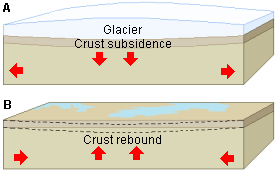
Britain is being pushed to the east by the expansion of the Atlantic Ocean and to the north by the impact of Africa into Europe from the south. It is also affected by lesser areas of tectonic spreading beneath the North Sea, Rhine Valley and Bay of Biscay. Finally the country is subject to glacial rebound; until about 10 000 years ago much of the north of the country was covered by a thick layer of glacial ice (this is believed to have been thickest on the west coast of Scotland), pushing the rocks of the British lithosphere down into the underlying mantle. This ice is now gone, and the rocks are springing (slowly) back into their original position, causing the occasional Earthquake in the process.

(Top) Simplified diagram showing principle of glacial rebound. Wikipedia. (Bottom) Map showing the rate of glacial rebound in various parts of the UK. Note that some parts of England and Wales show negative values, these areas are being pushed down slightly by uplift in Scotland, as the entire landmass is quite rigid and acts a bit like a see-saw. Climate North East.

Witness accounts of Earthquakes can help geologists to understand these events, and the structures that cause them. If you felt this quake, or were in the area but did not (which is also useful information) then you can report it to the British Geological Survey here.

See also...

The British Geological Survey recorded a Magnitude 1.1 Earthquake at a depth of 7 km between the villages of Sutton on the Hill and Marston on Dove in south...


A seven-year-old girl has escaped with cuts and bruises after falling into an 8 m sinkhole near her home in Shuttlewood, Derbyshire. Daisy-Mae Jones was playing with friends in a field near her home when she fell into the whole, which was about a meter across...

A sinkhole 50 m across and 40 m deep opened up near the village of Foolow in the Peak District, Derbyshire, England, early in the morning of Monday 30 December 2013. No buildings were damaged nor any...

Follow Sciency Thoughts on Facebook.

Tropical Storm Erika kills at least 25 in the Caribbean.

At least 36 people are known to have died and over 50 more are missing after Tropical Storm Erika swept across the islands of Dominica, Puerto Rico and Hispaniola this week. On Thursday 27 August the storm swept across the island of Dominica, bringing 38 cm of rain within 24 hours and causing widespread flooding and a number of landslides. Landslides are a common problem after severe weather events, as excess pore water pressure can overcome cohesion in soil and sediments, allowing them to flow like liquids. Approximately 90% of all landslides are caused by heavy rainfall. Twenty people have been confirmed dead on the island, and at least 31 more are known to be missing, with the death toll likely to rise as contact is made with remote parts of the mountainous country, where much of the transport infrastructure has been knocked out.

Flood damage in Roseau, Dominica on 28 August 2015. Robert Tonge/EPA.

After leaving Dominica the storm next passed over Puerto RIco, where power to around 200 000 households was cut, and crops with an estimated value of US$16 million, then the southern tip of Hispaniola, where it caused further flooding and at least five deaths. One person died in a landslide to the north of Port-au-Prince in Haiti, and four more were killed and another eleven injured after a truck carrying clairin (a form of raw liquor distilled from cane sugar) crashed into a bus shelter in heavy rain at Leogane and reportedly exploded.

The path to date of Tropical Storm Erika. Tropical Storm Risk.

Following its passage across southern Hispaniola the storm passed over the eastern part of Cuba, where it brought around two hours of heavy rain around the city of Santiago, prompting authorities to evacuate around 2000 people from low-lying areas.

Storm surge at Santo Domingo in the Dominican Republic on 28 August 2015. Erika Santelices/AFP.

Tropical storms are caused by the warming effect of the Sun over tropical seas. As the air warms it expands, causing a drop in air pressure, and rises, causing air from outside the area to rush in to replace it. If this happens over a sufficiently wide area then the inrushing winds will be affected by centrifugal forces caused by the Earth's rotation (the Coriolis effect). This means that winds will be deflected clockwise in the northern hemisphere and anti-clockwise in the southern hemisphere, eventually creating a large, rotating Tropical Storm. They have different names in different parts of the world, with those in the northwest Atlantic being referred to as hurricanes.

Damage to a home in Port-au-Prince, Haiti, on 29 August 2015. Dieu Nalio Chery/AP.

Despite the obvious danger of winds of this speed, which can physically blow people, and other large objects, away as well as damaging buildings and uprooting trees, the real danger from these storms comes from the flooding they bring. Each drop millibar drop in air-pressure leads to an approximate 1 cm rise in sea level, with big tropical storms capable of causing a storm serge of several meters. This is always accompanied by heavy rainfall, since warm air over the ocean leads to evaporation of sea water, which is then carried with the storm. These combined often lead to catastrophic flooding in areas hit by tropical storms.

See also...

Hurricane Arthur swept across the Outer Banks Islands of North Carolina on Friday 4 July 2014, causing flooding and disruption but with no reports of loss of life or serious damage. Maps of the...


Five members of of one family received minor injuries as part of a facade on the Brooklyn Bridge, New York, collapsed during...

Twelve people have died when a mudslide buried a bus in Altotonga in Veracruz State, Mexico, on Monday 16 September 2013. The...


Follow Sciency Thoughts on Facebook.

Cryptosporidium discovery at water treatment plant leaves around 300 000 without drinkable water in Lancashire, England.

Around 300 000 homes were left without drinkable water after the parasitic microorganism Cryptosporidium was discovered at the United Utilities operated Franklaw Water Treatment Plant near Preston in Lancashire, northwest England, on Thursday 6 August 2015. The parasite, which causes stomach cramps and diarrhea and which can cause severe and persistent infections in small children and people with immunological disorders, is notoriously hard to remove by the use of disinfectants and is best eradicated from water supplies with exposure to ultraviolet radiation. For this reason around 300 000 customers in the Blackpool, Chorley, Fylde, Preston, South Ribble and Wyre areas were advised to boil all water prior to use for consumption or cleaning from 7 August onwards. On Thursday 27 August United Utilities lifted the boil water on about 80 000 homes in the Preston, Blackpool and Chorley areas, and the company hopes to restore normal water supplies to all of its customers within a week.

Cryptosporidium: Mature schizont releasing merozoites. The spherical organisms releasing the crescent-shaped merozoites are seen attached to the microvillus brush border. RE Pugh/Deb Stenzel/Laurine Moreau.

Cryptosporidium is an Apicomplexan Protist (single celled Eukaryote, an organism having a cell nucleus) related to the pathogenic Toxoplasma and Malaria causing Plasmodium, though unlike these organisms it causes infections in Mammals and Birds without an intermediate invertebrate host. The organisms live and reproduce inside the small intestines of their hosts, producing large numbers of hardy cysts which are expelled in feces, and which can survive outside a host for long periods of time. It is these cysts which are resistant to disinfectants, making them problematic if they reach water treatment plants, swimming pools or similar man-made environments. Eventually the cysts reach a new host, typically via consumption of water, and mature to become reproductive schizonts, causing a new infection and repeating the infection cycle.

See also...

Water quality is a major issue in South Africa, where efforts to expand clean water supplies to the whole population in the post-Apartheid era have faced severe challenges due to a limited supply of potable...


Free-living Amoebae are unicellular protozoan’s common in aquatic ecosystems, which are also known to colonize Human created water systems such as water supply systems and swimming pools. Whilst in some ways these organisms can be helpful, consuming a range of Bacterial, Viral and Fungal pathogens...


Toxoplasma gondii is a protozoan parasite that affects humans, and many other animals, across the globe. While it causes disease in many organisms, it reproduces only in Felids, particularly in Domestic Cats, with oocysts (egg-like cysts) being shed in Cat faeces spreading the disease to many other organisms...


Follow Sciency Thoughts on Facebook.

Lonchophylla inexpectata: A new species of Nectar-feeding Bat from the Caatinga of Brazil.


Nectar-feeding Bats of the genus Lonchophylla are found tropical South and Central America, where they are important pollinators of some plant groups. There are currently twelve recognized species, with a cluster of smaller species having recently been transferred to another genus, Hsunycteris.

In a paper published in the journal ZooKeys on 22 July 2015, Ricardo Moratelli of the Fiocruz Mata Atlântica of the Fundação Oswaldo Cruz and the Division of Mammals at the National Museum of Natural History and Daniela Dias of the Laboratório de Biologia e Parasitologia de Mamíferos Silvestres Reservatórios at the Instituto Oswaldo Cruz, describe a new species of Nectar-feeding Bats of the genus Lonchophylla, from museum specimens collected in the arid Caatinga habitat (dry shrubland and thorn forest) of northeastern Brazil between 1908 and 1976.

The new species is named Lonchophylla inexpectata, where ‘inexpectata’ means ‘unexpected’. It is based entirely on museum specimens previously ascribed to the species Lonchophylla mordax, a species first described in 1903 from Brazil, and which formerly included populations from as far west as Colombia and Ecuador and as far north as Costa Rica, but which is now regarded as exclusively east-Brazilian in distribution. However, while previous taxonomists have removed distant populations from the species, it is currently considered to inhabit both the wet Atlantic Rainforests and arid Caatinga environment within this region, an improbable juxtaposition of habitats.

Moratelli and Dias examined museum specimens of ‘Lonchophylla mordax’ from both Atlantic Rainforest and Caatinga environments, and found that the Caatinga specimens were persistently paler than the Atlantic Forest specimens, many being described in museum records as ‘faded’. Further investigation revealed that these specimens also had smaller skulls, with narrower, more slender snouts, and slightly different dentition, with a well-developed lingual cusp (cusp on the inner, tongue, side of the tooth) on the fourth premolar, which was absent from the Atlantic Forest specimens.

Dorsal (A) and ventral (B) pelage of Lonchophylla inexpectata. Scale bar is 10 mm. Moratelli & Dias (2015).

Lonchophylla inexpectata has not yet been studied as a separate species in the wild, and its exact distribution is unclear, though museum specimens have been identified that were collected in both Pernambuco and Bahia States. However Moratelli and Dias note that expansion of agriculture in eastern Brazil has led to clearing of many areas of Atlantic Rainforest and its replacement with an artificial environment closer to the arid Caatinga, which may have led to Lonchophylla inexpectata expanding its range.

See also…

The diets of most Bats in the UK (and most other temperate countries) have been well studied in summer, but less so in winter. It was assumed for a long time that since such bats hibernate in winter, then they did not eat in winter months. However it is now known that most bat species cannot survive a whole winter...


Bats (Chiroptera) have long been considered to comprise about 25% of all Mammal species, but in recent years they have been shown to be considerably more diverse than previously thought, with a number of small, widespread Bat species being shown by genetic analysis to be made up of complexes of related but distinct cryptic species. Bats are morphologically...


Disk-winged Bats (Thyroptera) are small insectivorous foliage nesting Bats found in lowland moist forests from Mexico to southeastern Brazil. They are distinguished by small adhesive disks on their feet, an...


Follow Sciency Thoughts on Facebook.

Saturday, 22 August 2015

Magnitude 4.3 Earthquake beneath Escuintla Department, Guatemala.

The United States Geological Survey Recorded a Magnitude 4.3 Earthquake at a depth of 78 km in the west of Esculinta Department in southern Guatemala, slightly before 4.50 am local time (slightly 10.50 am GMT) on Friday 21 August 2015. This event was felt across in the municipality of Jocotenango, though there are no reports of any damage or casualties; which is roughly what would be expected from an Earthquake of this size at this depth; the quake is big enough to be felt over a wide area, but most of its energy has dissipated before the shock-waves reach the surface.

The approximate location of the 21 August 2015 Esculinta Earthquake. Google Maps.

Guatemala is located on the southern part of the Caribbean Plate, close to its boundary with the Cocos Plate, which underlies part of the east Pacific. The Cocos Plate is being pushed northwards by expansion of the crust along the East Pacific Rise, and is subducted beneath the Caribbean Plate along the Middle American Trench, which runs parallel to the south coast of Guatemala and neighboring countries, passing under Central America as it sinks into the Earth's interior. This is not a smooth process, the plates tend to stick together, breaking apart again once the pressure from the northward movement of the Cocos Plate builds up to much, triggering Earthquakes. 

Witness accounts of Earthquakes can help geologists to understand these events, and the structures that cause them. The international non-profit organization Earthquake Report is interested in hearing from people who may have felt this event; if you felt this quake then you can report it to Earthquake Report here.

See also...

The Instituto Nacional de Sismologia, Vulcanologia, Meteorologia, e Hidrologia in Guatemala has ordered an evacuation of communities close to Mount Fuego, an active volcano in the south of the country...


At least three people have died and several dozen more have been injured, following an Earthquake in the southeast of the Mexican state of Chiapas slightly after 6.20 am local time (slightly after 11.20 am GMT)...


The United States Geological Survey Recorded a Magnitude 5.0 Earthquake at a depth of 74.2 km in the east of Esculinta Department in southern Guatemala...


Follow Sciency Thoughts on Facebook.

Isolated Theropod teeth from the Middle Jurassic of Niger.


Unlike Mammals, Dinosaurs replaced their teeth throughout their lives, continuously growing new teeth and shedding older, worn ones. This, combined with the hard enamel coating found on all vertebrate teeth, makes isolated teeth the most commonly encountered Dinosaur specimens, so being able to accurately assign teeth to specific Dinosaur groups has great importance for understanding the origins and distributions of such groups. Within the Theropods, some groups have  very distinctive teeth which allow confident assignment of teeth by simple examination, for example Spinosaurid teeth have deeply veined enamel and fluted ridges, as well as tiny denticles (toothlets) on the carinae (cutting blades on the back of the tooth), however most groups lack such obvious characteristics and therefore palaeontologists have developed methods based upon morphometric analysis (mathematical comparison of different measurements and angles on a tooth, bone or shell), which allow isolated teeth to be compared to teeth found in situ on more complete fossil specimens.

In a paper published in the journal Acta Palaeontologica Polonca on 1 July 2015,  Alejandro Serrano-Martínez of the Grupo de Biología Evolutiva at the Universidad Nacional de Educación a Distancia, the Departamento de Biología at the Universidad Autónoma de Madrid and the Departamento de Paleobiología at the Museo Nacional de Ciencias Naturales, Daniel Vidal, also of the Departamento de Biología at the Universidad Autónoma de Madrid, Lara Scisio of the Department of Geological Sciences at the University of Cape Town, Francisco Ortega, also of the Grupo de Biología Evolutiva at the Universidad Nacional de Educación a Distancia, and Fabien Knoll of the Departamento de Paleobiología at the Museo Nacional de Ciencias Naturales, the School of Earth, Atmospheric and Environmental Sciences at the University of Manchester and the School of Earth Sciences at the University of Bristol describe four isolated Theropod Dinosaur teeth that were found in association with a fossil Sauropod, Spinophorosaurus nigerensis, from the late Middle Jurassic Tiourarén Formation of Aderbissinat in Niger.

The first tooth, MUPE HB-142 is also the best preserved, lacking only its tip, estimated to have been 31 mm in height, laterally compressed (flattened sideways) and curved towards the tip. It has an unserrated carina on its upper portion, and large, closely spaced denticles, with a density of roughly 2.25 denticles per mm. The crown of the tooth has undulations (wrinkles) close to the carina, and a slightly braded enamel texture.

MUPE HB-142 in close-up (A1), labial (A2), distal (A3), lingual (A4), and basal (A5) views. Scale bars (A1) 5 mm, all others 1 cm. Serrano-Martínez et al. (2015).

Morphometric analysis of MUPE HB-142 suggests that it probably derived from a Megalosaurid, as it shows affinities with Megalosaurus, Dubreuillosaurus and Afrovenator. However it also shows some affinities with the basal Tetanuran Torvosaurus, (the Tetanurans are a wider group which include the Megalosaurs, Allosaurs, Spinosaurs and other groups, basal Tetanurans are Tetanurans that predate the splitting of the Tetanurans into these groups) and falls within the morphospace (complete range of size and shapes) of both Megalosaurus and Allosaurus, though it is closer to average values for Megalosaurus, so the possibility that this tooth came from an Allosaurid cannot be ruled out.

The second tooth examined, MUPE HB-118, is the largest tooth in the collection, with a total height of 37.47 mm. This is similar in shape to MUPE HB-142, with denticles on the top third portion of the tooth and a similar braided texture to the enamel. The carina has chisel-like denticles, with a density of 3 per mm.

MUPE HB-118 in lateral (B1), close-up (B2), lateral (B3), distal (B4), and basal (B5) views. Scale bars, (B2) 2 mm, all others 1 cm. Serrano-Martínez et al. (2015).

This tooth also shows affinities to the Megalosaurids Megalosaurus, Dubreuillosaurus and Afrovenator, as well as with the early Neotheropod Dilophosaurus (related to but not included in the early Tetanurans) and the basal Tetanuran  Piatnitzkysaurus. Like MUPE HB-142 it falls within the morphospace of both Megalosarus and Allosaurus, but while MUPE HB-142 was closer to average values for Megalosaurus, MUPE HB-118 falls closer to average values for Allosaurus.  However the similarity of MUPE HB-118 to the teeth of Dubreuillosaurus and Afrovenator, combined with its proximity to another tooth assigned to a Magalosaurid and the absence of known Allosaurid teeth from the Southern Hemisphere in the Middle Jurassic leads Serrano-Martínez et al. to conclude that this is also a Magalosaurid tooth.

The third tooth examined, MUPE HB-125, is the smallest in the sample, and has a broken apex, and an estimated crown height of 20.26 mm. It is laterally flattened with a curved tip, though less so than MUPE HB-142 and MUPE HB-118. It has a carina occupying ¾ of the length of the tooth, with convex denticles on its bottom part and chisel-like denticles towards the top. The enamel of the tooth is unwrinkled, and shows only weak texturing.

MUPE HB-125 in lateral (C1, C3) and distal (C2) views. Scale bar 1 cm. Serrano-Martínez et al. (2015).

This tooth shows affinities to Allosaurus the Megalosaurids Dubreuillosaurus and Afrovenator,  and the basal Tetanuran Erectopus, but does not fall within the morphospace of any known Dinosaur group, lying between the values of Allosaurids, Megalosaurids and Dromaeosaurids. Again the close proximity of this tooth to other Megalosaurid teeth, and absence of known Allosaurid teeth from the Southern Hemisphere in the Middle Jurassic leads Serrano-Martínez et al. to conclude that this is more likely to be a Megalosaurid than an Allosaurid tooth.

The final tooth examined, MUPE HB-87, is less curved than the other specimens and 23.82 mm in height. It has a deeply veined enamel texture, and week undulations on the labial (inner) side of its carina. The carina itself has tightly packed chisel shaped denticles towards its tip, with smaller more convex denticles lower down.

MUPE HB-87, from the Middle Jurassic Tegama Group, Niger; in distal (A), lingual (B), mesial (C), and labial (D) views; close-up view of the labial side (E). Note the deeply veined enamel surface texture and the shape and size of the distal denticles. Scale bars (A−D), 1 cm; (E), 1 mm. Serrano-Martínez et al. (2015).

This tooth shows affinities to Allosaurus the basal Tetanuran Berberosaurus, but falls within the morphospace of the Spinosaurid group. It shows the deeply veined enamel texture typical of Spinosaurids (and never top date recorded in any non-Spinosaurid Dinosaur), but lacks the fluted ridges also typical of the group. It shows reduction in the size of denticles on the carina, but not to the extent seen in later Spinosaurids, and has other features intermediate between Spinosaurids and other Tetanuran groups, suggesting that it is an early member of the Spinosaur group, probably close to the split between this group and the related Megalosaurids.

The Spinosaurs are divided into two groups, the Baryonychines from Laurasia (North America, Europe and Asia) and the Spinosaurines in Gondwana (Africa, South America, India, Madagascar, Antarctica, Australia and New Zealand, though the group is not known from all these areas). However while the closely related Megalosaurs are well established in the Middle Jurassic, almost all known Spinosaur specimens come from the Cretaceous, making the origins of the group somewhat obscure. The Spinosaurines are generally considered to be more derived than the Baryonychines, which led palaeontologists to theorize that the group originated in Laurasia and spread to Gondwana, however recent discoveries of possible Spinosaurid teeth from the Middle Jurassic of Tanzania and Niger, combined with the presence of the group in Australia, which split away from the rest of Gondwana early in the break-up of the supercontinent, leads Serrano-Martínez et al. to suggest an alternative view, that the Spinosaurs originated in Africa in the Middle Jurassic and from there spread to other areas of Gondwana, as well as to Laurasia through Iberia and Europe.

Generalized palaeogeographic locations of spinosaurids (yellow) and the specimen of HB site (red), through time from Bajocian/Bathonian, Tithonian, Barremian−Aptian, and Albian−Cenomanian. Serrano-Martínez et al. (2015).

See also…

Large carnivorous Theropod Dinosaurs are considered to have been the top predators in Late Cretaceous...


Terrestrial faunas of the Triassic comprised a wide variety of large Vertebrates, including Synapsids and both Dinosaurian and non-Dinosaurian Archosaurs. At the end of the Triassic a major extinction event wiped out or greatly reduced most of these groups, with the...


A Megatheropod tooth from the Early Cretaceous of Guanxi Province, China.
In recent years China has become a focus for studies...


Follow Sciency Thoughts on Facebook.

Friday, 21 August 2015

Pearsonia lamphunensis: A new species of Cyclophorid Land Snail from Thailand.


Cyclophorid Land Snails are the most abundant group of terrestrial operculate Gastropods (Land Snails having an operculum, a lid which can be used to plug the shell opening) in Africa, Asia and Australia, and comprise 53 of the 234 known Land Snails in Thailand. Members of the genus Pearsonia are distinguished by a flattened, but not quite disk-shaped shell with a distinctive sutural tube that originates from the suture (join between two whorls of the shell) at the last part of the body whorl; they are known from India, Myanmar, South China, Laos and Malaysia, but have not previously been recorded from Thailand.

In a paper published in the Raffles Bulletin of Zoology on 1 July 2015, Sakboworn Tumpeesuwan of the Department of Biology and Palaeontological Research and Education Centre at Mahasarakham University and Chanidaporn Tumpeesuwan, also of the Department of Biology at Mahasarakham University describe a new species of Pearsonia from Lamphun Province in northern Thailand, the first member of the genus found in the country.

The new species is named Pearsonia lamphunensis, meaning ‘from Lamphun’. The species is described from four specimens, with shells measuring from 9 to 10 mm in height and 15 to 17 mm in width. All are dextral (curving to the right) and have 5¼–5½ whorls and a sutural tube which points backwards horizontally. The shells have a zig-zag patternation.

Pearsonia lamphunensis, aestivating living snail in natural habitat. Tumpeesuwan & Tumpeesuwan (2015).

See also…

Tryonia infernalis: A new species of Cochliopid Snail from a hot spring in the southern Nevada Desert.
The deserts of southeast California and southwest Nevada have been shown to host a distinctive fauna...

A new subspecies of Polygyrid Snail from West Virginia.
The Appalachian Mountain of eastern North America are considered to be a hotspot for Land Snail biodiversity. There are currently at least ten described species of Polygyrid Snails in the genus Triodopsis in West...


Dog Whelks, Nassariidae, are burrowing carnivorous Gastropods living in muddy or sandy sediments, from the intertidal zones to...

Follow Sciency Thoughts on Facebook.