Saturday, 28 April 2018

Thaumetopoea processionea: Warnings issued as Oak Processionary Moth invades London.

The public has been warned to be wary after colonies of Oak Processionary Moth caterpillars, Thaumetopoea processionea, have been sighted in several parts of London this month. The UK's Forestry Commission issued the warning about the caterpillars, which are native to southern Europe, after large colonies were spotted in several London boroughs as well as in the neighbouring counties of Berkshire and Surry. The caterpillars are covered in a dense coat of tiny hairs, which are covered in toxins that can cause skin complaints and respiratory problems, particulalrly in children, and which can achieve very high population densities in countries, such as the UK, where they have no natural predators.

Oak Processionary Moth caterpillars, Thaumetopoea processionea. Wikipedia.

Oak Processionary Moths are native to parts of Southern and Central Europe, where they have a number of natural predators. However a combination of a warming climate and accidental transplantation by Humans has led to the species becoming established in a number of countries in Northern Europe, where, in the absence of predators, they can form very large colonies, presenting problems for public health. 

As well as the obvious problems caused by detect contact with the caterpillars, the detached hairs, which can remain toxic for up to a decade, can present problems in themselves. Each individual hair has very little toxin, and does not present any danger to Humans, but they hairs can become concentrated in places such as the surfaces of still ponds, or in the hoppers of lawnmowers, resulting in unexpected contact with sufficient hairs to cause problems in places where the caterpillars are not present, which is particularly hasardous as the cause of the health problems triggered will not be clear, delaying appropriate treatment.

See also...

http://sciencythoughts.blogspot.co.uk/2018/04/ephysteris-kullbergi-ephysteris.htmlhttp://sciencythoughts.blogspot.co.uk/2018/03/phyllocnistis-indistincta-phyllocnistis.html
http://sciencythoughts.blogspot.co.uk/2018/03/dahlica-somae-dahlica-ochrostigma-two.htmlhttp://sciencythoughts.blogspot.co.uk/2018/01/elcysma-ziroensis-new-species-of-burnet.html
http://sciencythoughts.blogspot.co.uk/2017/12/lactura-rubritegula-new-species-of.htmlhttp://sciencythoughts.blogspot.co.uk/2017/08/pyrophleps-ellawi-new-species-of.html
Follow Sciency Thoughts on Facebook.

Landslide kills four in Murang'a County, Kenya.

Four people have died and another ten have been injured after a landslide swept through the village of Murarandia in Murang'a County, Kenya, on Friday 27 April 2018. All of the deceased are said to have been in the same house at the time of the incident, which swept away a kilometre long stretch of farmland as well as several homes. The incident happened after several hours of heavy rains in the area. Landslides are a common problem after severe weather events, as excess pore water pressure can overcome cohesion in soil and sediments, allowing them to flow like liquids. Approximately 90% of all landslides are caused by heavy rainfall.

 The aftermath of a landslide in Murang'a County, Kenya, on 27 April 2018. Grace Gitau/The Nation.

Several other villages in the area have also reported landslides, which have damaged homes and farmland, as well as killing some livestock. Flooding along the River Sagana has forced around 25 families to evacuate their homes and inundated a number of farms, while on the River Mathioya the Iyego Bridge has been reportedly been submerged. Flooding has also been reported in many other parts of the country.

Murang'a typically receives over 300 mm of rainfall in April, the county's wettest month, and falls within one of the area's two rainy seasons. This two rainy seasons per year pattern is typical in equatorial countries, with rainy seasons around the equinoxes and dry seasons around the solstices.

See also...

http://sciencythoughts.blogspot.co.uk/2018/03/dramatic-rifting-splits-roads-and-homes.htmlhttp://sciencythoughts.blogspot.co.uk/2018/03/ceratotherium-simum-cottoni-last_20.html
http://sciencythoughts.blogspot.co.uk/2018/03/ceratotherium-simum-cottoni-last.htmlhttp://sciencythoughts.blogspot.co.uk/2017/12/landslide-kills-three-illegal.html
http://sciencythoughts.blogspot.co.uk/2016/05/woman-confirmed-dead-following-kenyan.htmlhttp://sciencythoughts.blogspot.co.uk/2016/05/kenyan-artisanal-miner-killed-in.html
Follow Sciency Thoughts on Facebook.

Eruption on Piton de la Fournaise, Réunion Island.

The Observatoire Volcanologique du Piton de la Fournaise reported an eruption on Piton de la Fournaise, an active volcano on Réunion Island, an overseas department of France in the Indian Ocean, on Friday 27 April 2018. Seismic activity beneath the volcano began to increase sharply at about 8.15 pm local time, followed by an eruption that started at about 11.50 pm. This has been accompanied by the opening of an eruptive fissure on the southern flank of the volcano. Access to the summit of the volcano, which is home to several popular tourist trails, has been closed off due to concerns about the possibility of a collapse, and the Toulouse Volcanic Ash Advisory Centre has issued a warning to aviation in the area. 

Eruption on Piton de la Fournaise on 27 April 2018. Préfet de La Réunion/Twitter.

Piton de la Fournaise is believed to have been active for about 530 000 years, though its geology is complicated to unravel as lava flows are interbedded with those from Piton des Neiges, a larger, older and now extinct volcano to the northwest, which is responsible for the formation of about two thirds of the island. The island sits on the Réunion Hotspot, a deep mantle plume which is thought to have been active for about 66 million years, originally forming under what is now northeastern India, where it was responsible for the Deccan Traps flood basalts, then moving southward across the Indian Ocean (or more precisely sitting still while the continental plate upon which India and the Indian Ocean sit moves to the north), over time forming the Laccadive Islands, the Maldives, the Seychelles, Rodrigues Island, Mauritius and Réunion.

 The location of Piton de la Fornaise on Réunion Island.  Google Maps.

See also...

http://sciencythoughts.blogspot.co.uk/2018/04/volcanic-activity-on-reunion-island.htmlhttp://sciencythoughts.blogspot.co.uk/2017/01/magnitude-55-earthquake-in-central.html
http://sciencythoughts.blogspot.co.uk/2015/05/eruptions-on-piton-de-la-fournaise.htmlhttp://sciencythoughts.blogspot.co.uk/2015/02/eruptions-on-piton-de-la-fournaise.html
http://sciencythoughts.blogspot.co.uk/2014/01/fifteen-injured-as-cyclone-bejisa.htmlhttp://sciencythoughts.blogspot.co.uk/2012/05/eruption-on-mount-karthala.html
Follow Sciency Thoughts on Facebook.

Asteroid 2018 HC1 passes the Earth.

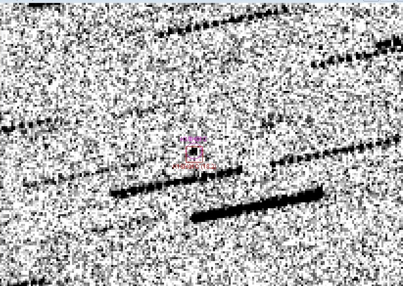
Asteroid 2018 HC1 passed by the Earth at a distance of about 471 700 km (1.23 times the average  distance between the Earth and the Moon, or 0.31% of the distance between the Earth and the Sun), slightly before 10.30 pm GMT on Thursday 19 April 2018. There was no danger of the asteroid hitting us, though were it to do so it would not have presented a significant threat. 2018 HC1 has an estimated equivalent diameter of 8-27 m (i.e. it is estimated that a spherical object with the same volume would be 8-27 m in diameter), and an object of this size would be expected to explode in an airburst (an explosion caused by superheating from friction with the Earth's atmosphere, which is greater than that caused by simply falling, due to the orbital momentum of the asteroid) in the atmosphere between 35 and 18 km above the ground, with only fragmentary material reaching the Earth's surface.

 Image of 2018 HC1 taken with the iTelescope T30 500 mm Reflector Deep Field Telescope at Siding Spring Observatory in New South Wales on 21 April 2018. The image is a composite of fifteen five second exposures, the dotted lines being stars which have moved over the course of the exposures and the asteroid the object circled in red at the centre of the image. Steven Tilley/iTelescope/Lagniappe Observing.

2018 HC1 was discovered on 21 April 2018 (two days after its closest approach to the Earth) by the University of Arizona's Catalina Sky Survey, which is located in the Catalina Mountains north of Tucson. The designation 2018 HC1 implies that it was the 28th asteroid (asteroid C1) discovered in the second half of April 2018 (period 2018 H).

The calculated orbit of 2018 HC1. Minor Planet Center.

2018 HC1 has an 879 day orbital period and an eccentric orbit tilted at an angle of 8.90° to the plane of the Solar System, which takes it from 0.75 AU from the Sun (i.e. 75% of he average distance at which the Earth orbits the Sun, slightly outside the orbit of the planet Venus) to 2.83 AU from the Sun (i.e. 283% of the average distance at which the Earth orbits the Sun, and almost twice as distant from the Sun as the planet Mars). It is therefore classed as an Apollo Group Asteroid (an asteroid that is on average further from the Sun than the Earth, but which does get closer). This means that close encounters between the asteroid and Earth are common, with the last having occurred in May 1941 and the next predicted in May 2117.

See also...

http://sciencythoughts.blogspot.co.uk/2018/04/asteroid-2018-hm-passes-earth.htmlhttp://sciencythoughts.blogspot.co.uk/2018/04/microtektites-from-transantarctic.html
http://sciencythoughts.blogspot.co.uk/2018/04/asteroid-2018-ge3-passes-earth.htmlhttp://sciencythoughts.blogspot.co.uk/2018/04/the-lyrid-meteor-shower.html
http://sciencythoughts.blogspot.co.uk/2018/04/asteroid-2018-gn-passes-earth.htmlhttp://sciencythoughts.blogspot.co.uk/2018/04/asteroid-2018-gu1-passes-earth.html
Follow Sciency Thoughts on Facebook.

Friday, 27 April 2018

Homonota marthae: A new cryptic species of Marked Gecko from northern Paraguay.

Marked Geckos of the genus Homonota are found across much of Central and South America, as well as on some Caribbean islands. These Lizards are generally nocturnal in nature, and favour dry rocky environments. There are currently twelve described species, though these are very similar in appearance, and the distributions of several species is poorly understood, so the group is likely to contain cryptic species (species which cannot be told apart easily by physical examination, but which are distinct genetically).

In a paper published in the journal Zoosystematics and Evolution on 28 February 2018, Pier Cacciali of the Senckenberg Forschungsinstitut und Naturmuseum, the Institute for Ecology, Evolution & Diversity at Johann Wolfgang Goethe-University, and the Instituto de Investigación Biológica del Paraguay, Mariana Morando and Luciano Avila of the Grupo de Herpetología Patagónica, and Gunther Köhler, also of the Senckenberg Forschungsinstitut und Naturmuseum, and the Institute for Ecology, Evolution & Diversity at Johann Wolfgang Goethe-University, describe a new species of Homonota from northern Paraguay.

The new species is named Homonota marthae, in honour of herpetologist Martha Motte of the Museo Nacional de Historia Natural del Paraguay. Homonota marthae closely resembles the previously described species Homonota septentrionalis, lacking only a white band above the eyes in adults (this is present in juveniles of both species and adults of Homonota septentrionalis); the two Geckos live alongside one another, and had been presumed to be colour variants of the same species, but were shown by genetic analysis to be distinct. 

Dorsal (A) and ventral (B) views of a female specimen of Homonota marthae. Cacciali et al (2018).

Adults of this species reach 36-59 mm in length, excluding the tail, and are sandy brown in colour with darker bands on their back and a line of keeled scales along their spine. The species lives in Dry Chaco Woodland (thornscrub) in the Department of Boquerón. It is apparently unbothered by Human disturbance of this environment, and will live in human dwellings quite happily, for which reason it is not considered to be endangered.

See also...

http://sciencythoughts.blogspot.co.uk/2016/12/gehyra-rohan-new-species-of-gecko-from.htmlhttp://sciencythoughts.blogspot.co.uk/2016/03/cyrtodactylus-petani-new-species-of.html
http://sciencythoughts.blogspot.co.uk/2015/08/calcified-lizard-eggs-with-preserved.htmlhttp://sciencythoughts.blogspot.co.uk/2014/11/a-new-species-of-velvet-gecko-from.html
http://sciencythoughts.blogspot.co.uk/2014/11/a-new-species-of-phasmid-gecko-from.htmlhttp://sciencythoughts.blogspot.co.uk/2014/09/four-new-species-of-forest-gecko-from.html
Follow Sciency Thoughts on Facebook.
Magnitude 4.7 Earthquake on the north coast of Venezuala.

The United States Geological Survey recorded a Magnitude 4.7 Earthquake at a depth of 10.0 km roughly 4 km northwest of the city of San Diego in Carabobo State, Venezuela, slightly before 4.45 am local time (slightly before 8.45 am GMT) on Friday 27 April 2018. There are no reports of any casualties associated with this event, though the quake was felt over a large area, with people reporting feeling it across much of northeast Venezuela, and some superficial damage to buildings has been reported.

Damage to a building in northern Venezuela following the 27 April 2018 Earthquake. La Patilla.

The southern margin of the Caribbean Plate lies just off the northern coast of Venezuela, this is moving eastward compared to the South American Plate, upon which most of Venezuela sits. This is not a smooth process, the two plates constantly stick together, then break apart as the pressure builds up, causing Earthquakes in the process.

The approximate location of the 27 April 2018 Carabobo Earthquake. Google Maps.

Witness accounts of Earthquakes can help geologists to understand these events, and the structures that cause them. The international non-profit organisation Earthquake Report is interested in hearing from people who may have felt this event; if you felt this quake then you can report it to Earthquake Report here.
 
See also...
 
http://sciencythoughts.blogspot.co.uk/2017/11/measles-outbreak-in-bolivar-state.htmlhttp://sciencythoughts.blogspot.co.uk/2015/11/magnitude-53-earthquake-in-northwest.html
http://sciencythoughts.blogspot.co.uk/2015/04/magnitude-52-earthquake-off-paria.htmlhttp://sciencythoughts.blogspot.co.uk/2015/02/the-role-of-gold-mining-in.html
http://sciencythoughts.blogspot.co.uk/2013/10/magnitude-61-earthquake-of-north-coast.html
Follow Sciency Thoughts on Facebook.

Thursday, 26 April 2018

Flash flood kills nine teenagers in southern Israel.

Nine teenagers have died after being caught in a flash flood in the Tzapit River Valley in southern Israel on Thursday 26 April 2018. The nine were on an exercise with a pre-military training course organised by the Bnei Zion Academy in Tel Aviv, when the bus they were in was carried away by a surge that swept down the valley. The nine were part of a group of 24, and have been described as eight boys and a girl, though they have not been named. Two other teenagers were injured in the incident. Concerns have been raised as to why the exercise was taking place, as storm warnings had been issued for the area.

Rescue teams recovering the bodies of a group of teenagers killed in a flash flood in southern Israel on 26 April 2018. Zaka.

Like many desert areas southern Israel, while generally arid, is prone to occasional severe flooding. This stems from two causes; firstly the arid climate prevents the development of a thick soil layer which would be expected in less dry areas, so that in much of the area (non-porous) bedrock is either exposed or close to the surface, and secondly the hot climate leads to heavy evaporation from nearby seas and oceans, so that if the wind changes direction and brings water-laden air to the area, it brings a lot of precipitation with it. This combination of heavy rainfall and low ground absorbency leads to large amounts of water at the surface, typically moving downhill at some speed. Wadis, dry channels or ravines through which these sudden floods are channelled, can be particularly dangerous at these times, particularly as they often appear to resemble natural pathways or even camp sites to people unfamiliar with the climate.

See also...

http://sciencythoughts.blogspot.co.uk/2016/12/fire-at-oil-refinery-in-haifa-israel.htmlhttp://sciencythoughts.blogspot.co.uk/2016/10/twenty-six-confirmed-deaths-in-egypt.html
http://sciencythoughts.blogspot.co.uk/2015/05/natural-gas-pipeline-blown-up-in-north.htmlhttp://sciencythoughts.blogspot.co.uk/2014/07/magnitude-41-earthquake-off-coast-of.html
Follow Sciency Thoughts on Facebook.