Tuesday, 31 December 2024

Major rockfall at West Bay on England's Jurassic Coast.

A major rockfall has occurred at West Bay on the coast of Dorset in southern England, blocking passage along the beach between Freshwater and West Bay. The rockfall was first noticed on the morning of Monday 30 December, with the event presumably happening at some time the night before. Dorset Council are warning people to keep away from the debris left by the rockfall, as there is a significant danger of further falls around the same point, and the height and steepness of the cliffs at West Bay mean that falling debris present a very serious threat to the lives of anybody in their way.

A rockfall observed on the Beach at West Bay, Dorset, on the morning of 30 December 2024. Stephen Beardshall/Dorset Echo.

The cliffs at West Bay form part of the Jurassic Coast World Heritage Site, a 150 km stretch of the coast of Dorset and Devon, noted for its geological splendour, and in particular the many sites where it is possible, and relatively easy, to collect fossils. Because rockfalls frequently expose new fossil material, they are often attractive to (sometimes over-intrepid) fossil-hunters, however, the rocks at West Bay seldom, if ever, produce any fossils, whilst rockfalls there present a serious danger of death.

See also...

Monday, 30 December 2024

Sinkhole closes Interstate 80 highway in New Jersey.

A section of the Interstate 80 highway in Morris County, New Jersey was closed to eastbound traffic after a sinkhole opened beneath it on Thursday 26 December 2024. The sinkhole, which was about 12 m across and about 12 m deep appeared close to the town of Wharton, and was first spotted at about 7.40 am local time. Engineers have excavated around the area and then backfilled the whole area with rock and concrete, and expect the highway to reopen on Monday 30 December.

A sinkhole which appeared beneath the Interstate 80 highway in Morris County, New Jersey, on 26 December 2024. WABC.

Sinkholes are generally caused by water eroding soft limestone or unconsolidated deposits from beneath, causing a hole that works its way upwards and eventually opening spectacularly at the surface. Where there are unconsolidated deposits at the surface they can infill from the sides, apparently swallowing objects at the surface, including people, without trace. 

Repairs being carried out to the Interstate 80 highway near Wharton, New Jersey, following the opening of a sinkhole on 26 December 2024. NorthJersey.com.

On this occasion the sinkhole is thought to have been caused by the collapse of an abandoned mineshaft beneath the highway. Morris County was once home to a hundred mine, principally targeting iron ore, many of which dated back to the eighteenth century, and therefore were poorly mapped by modern standards. The last of these mines closed in 1986, but abandoned mines still occasionally cause problems, including sinkholes, in the area. The Mount Pleasant Mine, which opened in 1786 and closed in 1896 is thought to have run beneath the modern Interstate 80 highway. The mine comprised a single inclined tunnel, which averaged 2 m in width and reached over a kilometre in length and more than 424 m beneath the surface.

See also...

Sunday, 29 December 2024

Late Pleistocene-Early Holocene faunal remains from the Waterfall Bluff Rock Shelter in the Mpondoland region of Eastern Cape Province, South Africa.

A number of coastal archaeological sites across Southern Africa provide an excellent record of faunal and Hominin interactions during Pleistocene interglacial periods and the Holocene, but a much poorer record of the same during glacial periods, when sealevels were lower, with the effect that most coastal settlements during these intervals would be below modern sealevels. The Waterfall Bluff Rock Shelter in the Mpondoland region of Eastern Cape Province, appears to be an exception to this, with an archaeological record which begins during Marine Isotope Stage 3 (roughly 39 000 to 29 000 years ago) to the Early Holocene (about 8000 years ago), and includes the Last Glacial Maximum, and the glacial/interglacial transition at the end of the Pleistocene. This site has yielded the remains of Fish, Shelfish, and Marine Mammals, which demonstrate that the hunter-gatherer populations using the rock shelter were utilizing coastal resources even during the Last Glacial Maximum.

In a paper published in the South African Journal of Science on 4 December 2024, Sandee Oster and Jerome Reynard of the School of Geography, Archaeology and Environmental Studies at the University of the Witwatersrand, Hayley Cawthra of the African Centre for Coastal Palaeoscience at Nelson Mandela University, and the Minerals and Energy Unit at the South African Council for GeoscienceIrene Esteban, also of the African Centre for Coastal Palaeoscience at Nelson Mandela University, and of the Archaeological and Archaeometric Research Unit and Institute of Archaeology at the University of Barcelona, Justin Pargeter of the Department of Anthropology at New York University, and the Rock Art Research Institute at the University of the Witwatersrand, and Erich Fisher, again of the African Centre for Coastal Palaeoscience at Nelson Mandela University, and of the Evolutionary Studies Institute at the University of the Witwatersrand, the Interdisciplinary Center for Archaeology and the Evolution of Human Behavior at the University of Algarve, and the Institute of Human Origins at Arizona State University, present a preliminary analysis of the fauna at the Waterfall Bluff Rock Shelter, and discuss the implications of this for the local palaeoenvironmental and palaeoecological conditions, and how this would have affected the subsistence activities of hunter-gatherer populations in the area.

Eastern Mpondoland, defined as the area between the mouths of the Mthatha and Umtamvuna rivers, has a diverse landscape with a number of deeply incised plateaus, and areas of sourveld grassland, forest vegetation and bushveld, with patches of Southern Coastal Forest, Southern Mistbelt Forest and Scarp Forest. This area has a diverse fauna including woodland species such as bushbuck, Tragelaphus scriptus, Blue Duiker, Philantomba monticola, and Grey Rhebok, Pelea capreolus, grassland species such as Southern Reedbuck, Redunca arundinum, Oribi, Ourebia ourebi, and Bontebok, Damaliscus pygargus,  as well as mixed environment species such as Eland, Tragelaphus oryx.

Waterfall Bluff Rock Shelter is located 24 m above sealevel, close to the Mlambomkulu River Waterfall. It has yielded an assemblage of lithic tools, predominantly made from hornfels (metamorphically altered sandstone), as well as Plant remains which have been used to demonstrate that all the vegatation types found in the area have been present since the End Pleistocene. More than 17 000 items have been recovered from the site to date, including tools, Plant, and Animal remains.

Two broad stratigraphic layers, termed Stratigraphic Aggregates, or 'StratAggs', have been determined from the rock shelter. These are somewhat homogenised internally, but apparently distinct from one-another. The oldest is the Light Brown Coarse Sands, which has been dated to between 37 600 and 12 500 years before the present. Overlying this is the Shell-Rich Clayey Sands, dated to between 11 000 and 10 500 years before the present, both of which can be sub-divided into a number of discrete sub-units, termed sub-Stratigraphic Aggregates, or 'SubAggs'.

The ages and locations of SubAggs at Waterfall Bluff. Oster et al. (2024).

The material used in Oster et al.'s study was excavated in 2016 under permit from the Eastern Cape Provincial Heritage Resources Authority, and with the support of King Zanozuko Tyelovuyo Sigcau, Nkosi Mthuthuzeli Mkwedini, and the Lambasi AmaMpondo community. Specimens were compared to reference material in the collection of the Ditsong National Museum. Where Bovid remains could not be identified they were split into four size classes, with (1) being the smallest, and including species such as Oribi, and (4) is the largest, including species such as Eland. Where the species could be determined, ungulates were categorised as grazers, browsers or mixed feeders.

The majority of the specimens came from the Early Holocene Shell-Rich Clayey Sands, with a smaller amount from the Late Pleistocene Light Brown Coarse Sands. The majority of the material was extremely fragmentary, typically less than 2 cm on the longest dimension. About 10% of the material showed signs of Human modification, such as cut or percussion marks, though only one of these modified bones could be assigned to species level, a charred astragalus with cut marks from the Early Holocene determined to come from a Blue Duiker.

The most common Animals in the sample were Bovids (the group that includes Antelopes), while the most easily identifiable remains were those of Rock Hyraxes, Procavia capensis. A single Seal-tooth was found in a Pleistocene layer dated to between 22 560 and 19 430 years before the present. This was determined to have come from a Leopard Seal, Hydrurga leptonyx, a species which today is found on Antarctic and sub-Antarctic islands, and the waters which surround these, although occasional visitors to South Africa are recorded. The presence of such a tooth in a Pleistocene layer at the Waterfall Bluff Rock Shelter could imply that during this period, when sea temperatures would have been about 3° lower that today, Leopard Seal colonies were found further north, on the South African coast, or simply that individuals occasionally visited the area, as they do today. Three Seal bone specimens were also found, a vertebra and two bone fragments, from both the Pleistocene and Holocene layers, although these could not be identified more precisely.

Leopard Seal tooth from Waterfall Bluff Rock Shelter (#CN47208, Lot 303). Oster et al. (2024).

Only two Bovid specimens could be identified from the Late Pleistocene deposits, a Common Duiker, which is an obligate woodland species, and an Eland, which is environmentally adaptable. No obligate grassland species could be identified, but with the very small sample size, it would be problematic to place much emphasis on this.

Both Fish and Seal remains were found in Late Pleistocene layers along with marine Shelfish and possible Barnacle fragments, suggesting that the area was within practical range of the coast even during periods of glaciation. This is not completely surprising as the coastal shelf is narrow on this part of the coast (i.e. at the edge of the continental shelf the seafloor is steep, so that the sealevel can drop a long way vertically without moving far horizontally), although even at this time it was probably about 8 km from the rock shelter.

In the Early Holocene, Bushbuck and Reedbuck were both common. Since these species favour riverine environments, suggesting that the Mlambomkulu River had continued to run at this time; this supports earlier findings of incisions on the (now submerged) continental shelf, which also support the presence of a river. Reedbuck also favour grassland environments, as do African Buffalo and Bontebok/Blesbok, which were also fairly common in the Holocene layers, suggesting a grassland environment was definitely present by this time. The presence of Blue Duiker and Vervet Monkeys, which are obligate woodland species, indicate that woodland was still present, hinting at an environment not much different from today.

See also...

Unkown disease in the Democratic Republic of Congo determined to be Acute Respiratory Infections complicated by Malaria and Malnutrition.

On 8 December 2024 the World Health Organization and Ministry of Health of the Democratic Republic of Congo reported an outbreak of an unknown disease in the Panzi Health Zone of Kwango Province, which had infected 406 people and killed 31 people (a case fatality rate of 7.8%) between 24 October and 5 December 2024. The symptoms of the disease include fever, headache, cough, runny nose, and body ache, and it was particularly hazardous to children, with 71% of fatalities in under-fifteen-year-olds. The remote nature of the area affected, which lacks both any form of diagnostic laboratory and good transport links to anywhere that does, were making it hard to determine the cause of the disease, although specialist teams were being dispatched to the area to try to resolve the situation at that time.

An updated report on the situation published by the World Health Organization on 27 December 2024 noted that since the initial report a further 485 cases of the disease had been reported in 25 of the 30 Health Areas which make up the Panzi Health Zone before 16 December, with an additional seventeen deaths. All the victims appeared to be suffering from a combination of febrile illness with acute respiratory symptoms and anaemia, all of which are common symptoms of infections around the onset of the rainy season in the Democratic Republic of Congo, but the number of deaths is far higher than would normally be expected.

In he absence of a clinical diagnosis of the disease, health workers adopted a surveillance-based case definition, which included people living in the Panzi Health Zone from September 2024 suffering from fever and/or a cough and/or body weakness and/or a runny nose, with or without any of chills, headache, difficulty breathing, malnutrition, or body aches.

From 24 October to 16 December 2024, 891 patients were treated for illnesses which matched these infections, with 48 recorded fatalities. Children were disproportionately impacted, with 47% of cases and 54% of fatalities among those under five years old (who make up about 18% of the population). Those who died were disproportionately likely to be suffering from difficulty breathing, anaemia, and acute malnutrition.

Four hundred and thirty blood samples, oropharyngeal and nasopharyngeal swabs, urine and breastmilk samples were collected from patients and transported to the Institut National de Recherche Biomédicale in Kinshasa. Eighty nine of these samples have been tested to date (further tests are ongoing), sixty four of which have proved to be positive for common respiratory infections, including the H1N1 Influenza Virus (25 cases), Rhinoviruses (18 cases), COVID-19 (15 cases), other Coronaviruses (3 cases), Parainfluenza Viruses (2 cases), and Human Adenovirus (1) case. In addition, 88 samples were subject to rapid diagnosis tests for Malaria in the field, with 56 (62%) being positive.

Based upon these findings, health workers in Panzi Health Zone have concluded that the 'epidemic' has been caused by a combination of common Viral respiratory infections combined with Malaria and acute malnutrition.

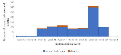
The number of both cases and deaths has remained steady since the onset of monitoring, with the exception of a spike in the number of reported cases in the week ending 15 December, which may relate to either the onset of the seasonal rains or the deployment of rapid response teams carrying out additional surveillance work; notably, this rise in the number of cases detected was not matched by a rise in the number of fatalities reported.

Weekly epidemiological curve showing suspected cases and deaths reported between 24 October to 16 December 2024, Panzi Health Zone in Kwango Province, Democratic Republic of the Congo. World Health Organization.

More cases of infection have been reported in females than males (58%), however, this is disproportionately true of adults (68% of adult infections), and may therefore reflect the role of women in looking after sick children, and therefore being more likely to become infected within households, rather than a greater biological vulnarability to any of the infections involved.

The affected area has been suffering from a deterioration in food security for some months, with a subsequent increase in the number of cases of acute malnutrition. Between July and December 2024, a period which should normally coincide with a drop in the number of cases of acute malnutrition, Kwango Province was deemed to be in Acute Malnutrition Phase 3 (Serious) under the Integrated Food Security Phase Classification system. Between January and June 2025, a period when the situation would be expected to get worse most years, it is probable that the province will move to Acute Malnutrition Phase 4 (Critical). It is predicted that between July 2025 and June 2024, 4.5 million children between the ages of six months and five years will face acute malnutrition in the Democratic Republic of Congo, with 1.4 million cases of severe acute malnutrition (defined as acute malnutrition which is immediately life-threatening without medical treatment) expected. During the same period 3.7 million pregnant and breastfeeding women will also face acute malnutrition in the country.

Geographic location of the affected health zone in Kwango Province, Democratic Republic of the Congo. World Health Organization.

The effects of disease and malnutrition combine and intensify one-another. Panzi Health Zone has poor vaccine coverage, poor access to diagnostic equipment, and little of the infrastructure needed for effective case management. The area has a shortage of health workers, lacks supplies of medical equipment, and is poorly connected to the outside world by transport networks. The onset of the rainy season is expected to bring a steep rise in the number of Malaria infections, and the combination of problems  is likely to make the population more vulnerable to both Malaria and common respiratory infections.

See also...

Saturday, 28 December 2024

Ichthyophis yangi: A new species of Caecilian from China.

Caecilians are limbless burrowing Amphibians found in tropical regions of Asia, Africa and South America. They resemble Earthworms, with circular folds on their skin which make them look segmented and skin covering their eyes (though they can see), though they are true Vertebrates with visible jawbones, which all Worms lack.. Unlike snakes they have greatly reduced or even absent tails with their anus close to or at the tips of their bodies. Caecilians are predatory with a well developed sense of smell. 

Members of the Family Ichthyophiidae are found in Asia from India east to the Philippines, and south through Myanmar to southern China, Thailand, and the Malayan Archipelago, ultimately reaching the Wallace Line. the Ichthyophiidae was formerly divided into three genera, CaudacaeciliaIchthyophis, and Uraeotyphlus, but molecular phylogenies have suggested that Caudacaecilia and Ichthyophis are not genetically distinct, and thus all species from both genera have been placed in the single genus Ichthyophis (this having been named first). Thus, Ichthyophis currently contains 49 species of Caecillians, in two distinct colour types, one having a pair of lateral stripes in a yellow or cream colour, and one lacking any such. All members of a species appear to always belong to a single colour type, but this is no guide to relationships between species.

In a paper published in the journal Asian Herpetological Research on 9 December 2024, Dingqi Rao and Hongxin Zhou of the Kunming Institute of Zoology, Mingzhong Mo of the Forestry and Grassland Administration of Honghe Prefecture, Zhiyong Yu of the Fenshuiling National Nature Reserve, and Xiuyan Li and Shou Liu, also of the Kunming Institute of Zoology, describe a new species of Ichthyophis from Yunnan Province, China.

In 1922 German zoologist Rudolph Mell reported observing a unmarked species of Ichthyophis on Luofu Mountain in Guangdong Province, but aside from this, all other records of the genus in China are of striped species. Then, in June 2023, a group of local residents in Jinping County of Yunnan Province found a dead and partially dried Caecilian beside a road near the village of Maandi, which they took to Mingzhong Mo. He in turn took it to the Kunming Institute of Zoology, where it was recognised as a stripeless Ichthyophis.

A subsequent search of the area by zoologists from the Kunming Institute of Zoology recovered another five specimens, including two sub-adults, all od which were lacking in stripes. A subsequent genetic analysis confirmed that these were a new species of Ichthyophis, forming a sister species to Ichthyophis chaloensisi, a stripeless species from Vietnam. The new species is named in honour of Datong Yang, the first herpetologist to describe a new species of Ichthyophis from China.

Holotype of Ichthyophis yangi in life. Rao et al. (2024).

The largest specimen of Ichthyophis yangi is 324 mm in length and 16 mm wide at its mid-body. All are grey in colour, without any markings. The head is flattened and widest behind the mouth, tapering towards the tip of the snout. The eyes are covered by skin. Teeth are small and hook-shaped. The species is only known from the area around Maandi Village, with most specimens found under stones on farmland close to a stream.

(A) Habitat of Ichthyophis yangi. (B) The place where holotype of Ichthyophis yangi was discovered. Jingchao Wang in Rao et al. (2024).

See also...