Showing posts with label Banda Sea Plate. Show all posts

Friday, 31 December 2021

Magnitude 7.3 Earthquake to the northeat of Timor Leste (East Timor).

The United States Geological Survey recorded a Magnitude 7.3 Earthquake at a depth of 166.9 km beneath the Banda Sea, roughly 121 km to the northeast of Timor Leste (formerly East Timor), at about 3.25 am local time on Thursday 30 December 2021 (about 9.25 pm on Wednesday 29 December GMT). Quakes at this depth are seldom dangerous, but are often felt over a wide area, and this one was felt across the island of Timor and in the Northern Territory of Australia in the area around Darwin.
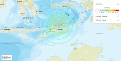
 
The approximate location of the 30 December 2021 Banda Sea Earthquake (USGS).

The Banda Sea is underlain by two tectonic plates, the Banda Sea Plate and the Timor Plate; two small plates caught between the colliding Eurasian, Pacific and Australian Plates. The Timor Plate is being subducted beneath the Banda Sea Plate. As it sinks into the Earth the subducting plate is being melted by the heat of the planets interior; some of the melted material then rises through the overlying Banda Sea Plate, fuelling volcanism on a number of islands in the region. This is not a smooth process, and the plates frequently stick together then break apart as the pressure builds up, leading to Earthquakes in the region.
See also...


Follow Sciency Thoughts on Facebook.

Follow Sciency Thoughts on Twitter


Monday, 30 November 2020

Thousands evacuated as Mount Lewotolo erupts in eastern Indonesia.

The Pusat Vulkanologi dan Mitigasi Bencana Geologi (Center for Vulcanology and Geological Disaster Mitigation) has ordered about 2800 people to evacuate their homes in 28 villages on Lembata Island in the Lesser Sunda Islands of Indonesia, following an eruption on Mount Lewotolo on Sunday 29 November 2020. The eruption produced an ash column about 4 km high, leading to ash falls in several areas, and leading to the closure of Wunopitu Airport. There are no reports of any casualties associated with this eruption, however the evacuations are still ongoing, and there are concerns about the whereabouts of five children from Waienga, who are believed to have fled into a forest in panic after the volcano erupted, and who have not yet been located.

 
An ash column over Mount Lewotolo on Lembata Island in the Lesser Sunda Islands on 29 November 2020. Muhammad Ilham/Reuters.

Lembata sits on the northern part of the Timor Microplate; a small fragment of crust caught between the Banda Sea Plate to the north and the Australian Plate to the south. Both these other plates are subducting beneath the Timor Plate, and as they sink into the Earth, melted by the friction and the heat of the planets interior. Some of this melted material then rises through the overlying plate, fuelling the volcanoes of Flores, Timor and the neighbouring islands.

 
The subduction zones beneath the Timor Microplate. Hamson (2004).

See also...


Follow Sciency Thoughts on Facebook.

Follow Sciency Thoughts on Twitter.


Sunday, 15 December 2019

Magnitude 6.9 Earthquake in Davao del Sur Province, the Philippines.

The Philippine Institute of Volcanology and Seismology recorded a Magnitude 6.9 Earthquake at a depth of 3 km about 5 km to the west of the town of Matanao in Davao del Sur Province on Mindanao Island, Philippines, slightly after 2.10 pm local time (slightly after 6.10 am GMT) on Sunday 15 December 2019. The Earthquake is known to have killed at least four people, including a six-year-old girl, and injured many more, mostly in building collapses with the event being felt across the southern Philippines. 

 Vicitms of the 15 December 2019 Davao del Sur Earthquake, trapped beneath a wall in the town of Padada. Korte Supremo/Twitter.

The geology of the central Philippines is Complex. The west of Mindanao Island is located on the Banda (or Sunda) Microplate, and the east on the Philippine Plate, which is being subducted beneath the Sunda (or Banda) Microplate along the central part of the island. Immediately to the east of the Island the Pacific Plate is being subducted along the Philippine Trench, and passes beneath eastern Mindanao as it sinks into the Earth. This is not a smooth process, an the plates constantly stick together then break apart again as the pressure builds up, resulting in Earthquakes.

 Subduction beneath the Philippines. Yves Descatoire/Singapore Earth Observatory.

Witness accounts of Earthquakes can help geologists to understand these events, and the structures that cause them. The international non-profit organisation Earthquake Report is interested in hearing from people who may have felt this event; if you felt this quake then you can report it to Earthquake Report here.

The location of the 15 December 2019 Davao del Sur Province Earthquake. Contour lines show rates of movement during the quake, the red line is a boundary between two tectonic plates, in this case the Pacific and Philippine plates. USGS.

See also...

https://sciencythoughts.blogspot.com/2019/12/typhoon-kammuri-causes-at-least.htmlhttps://sciencythoughts.blogspot.com/2019/11/magnitude-65-earthquake-in-cotabato.html
https://sciencythoughts.blogspot.com/2019/10/magnitude-66-earthquake-beneath.htmlhttps://sciencythoughts.blogspot.com/2019/10/magnitude-63-earthquake-beneath.html
https://sciencythoughts.blogspot.com/2019/09/magnitude-64-earthquake-to-southeast-of.htmlhttps://sciencythoughts.blogspot.com/2019/06/magnitude-62-earthquake-to-southeast-of.html
Follow Sciency Thoughts on Facebook.

Monday, 30 September 2019

Magnitude 6.4 Earthquake to the southeast of Mindanao Island, the Philippines.

The Philippine Institute of Volcanology and Seismology recorded a Magnitude 6.4 Earthquake at a depth of 63 km about 80 km off the southeast coast of Mindanao Island, Philippines, slightly 3.00 pm local time(slightly after 2.00 am GMT) on Sunday 29 September 2019. There are no reports of any damage or casualties associated with the event, but it was felt across the southern Philippines and central Indonesia.

 The approximate location of the 29 September 2019 Mindanao Earthquake. USGS.

The geology of the central Philippines is Complex. The west of Mindanao Island is located on the Banda (or Sunda) Microplate, and the east on the Philippine Plate, which is being subducted beneath the Sunda (or Banda) Microplate along the central part of the island. Immediately to the east of the Island the Pacific Plate is being subducted along the Philippine Trench, and passes beneath eastern Mindanao as it sinks into the Earth. This is not a smooth process, an the plates constantly stick together then break apart again as the pressure builds up, resulting in Earthquakes.

 Subduction beneath the Philippines. Yves Descatoire/Singapore Earth Observatory.

Witness accounts of Earthquakes can help geologists to understand these events, and the structures that cause them. The international non-profit organisation Earthquake Report is interested in hearing from people who may have felt this event; if you felt this quake then you can report it to Earthquake Report here.

See also...

https://sciencythoughts.blogspot.com/2019/06/magnitude-62-earthquake-to-southeast-of.htmlhttps://sciencythoughts.blogspot.com/2018/12/magnitude-70-earthquake-to-southeast-of.html

https://sciencythoughts.blogspot.com/2018/02/landslides-and-flooding-kill-five-as.htmlhttps://sciencythoughts.blogspot.com/2018/01/landslides-kill-six-in-philippines.html
https://sciencythoughts.blogspot.com/2017/12/flash-flood-destroys-village-on.htmlhttps://sciencythoughts.blogspot.com/2017/05/magnitude-69-earthquake-off-south-coast.html
Follow Sciency Thoughts on Facebook.

Saturday, 1 June 2019

Magnitude 6.2 Earthquake to the southeast of Mindanao Island, the Philippines.

The Philippine Institute of Volcanology and Seismology recorded a Magnitude 6.2 Earthquake at a depth of 78 km about 50 km off the southeast coast of Mindanao Island, Philippines, slightly 6.10 pm local time(slightly after 10.10 am GMT) on Friday 31 May 2019. There are no reports of any damage or casualties associated with the event, but it was felt across southeast Mindanao.

 The approximate location of the 29 December 2018 Mindanao Earthquake. USGS.

The geology of the central Philippines is Complex. The west of Mindanao Island is located on the Banda (or Sunda) Microplate, and the east on the Philippine Plate, which is being subducted beneath the Sunda (or Banda) Microplate along the central part of the island. Immediately to the east of the Island the Pacific Plate is being subducted along the Philippine Trench, and passes beneath eastern Mindanao as it sinks into the Earth. This is not a smooth process, an the plates constantly stick together then break apart again as the pressure builds up, resulting in Earthquakes.

Subduction beneath the Philippines. Yves Descatoire/Singapore Earth Observatory.

Witness accounts of Earthquakes can help geologists to understand these events, and the structures that cause them. The international non-profit organisation Earthquake Report is interested in hearing from people who may have felt this event; if you felt this quake then you can report it to Earthquake Report here.
 
See also...
 
https://sciencythoughts.blogspot.com/2018/12/magnitude-70-earthquake-to-southeast-of.htmlhttps://sciencythoughts.blogspot.com/2018/02/landslides-and-flooding-kill-five-as.html
https://sciencythoughts.blogspot.com/2018/01/landslides-kill-six-in-philippines.htmlhttps://sciencythoughts.blogspot.com/2017/12/flash-flood-destroys-village-on.html
https://sciencythoughts.blogspot.com/2017/05/magnitude-69-earthquake-off-south-coast.htmlhttps://sciencythoughts.blogspot.com/2017/04/magnitude-53-earthquake-off-northeast.html
Follow Sciency Thoughts on Facebook.

Saturday, 29 December 2018

Magnitude 7.0 Earthquake to the southeast of Mindanao Island, the Philippines.

The United States Geological Survey recorded a Magnitude 7.0 Earthquake at a depth of 60.1 km about 83 km off the southeast coast of Mindanao Island, Philippines, slightly before 3.40 am local time on Saturday 29 December 2018 (slightly after 7.40 pm on Friday 28 December GMT). There are no reports of any damage or casualties associated with the event, but it was felt across Mindanao, as well as on the Indonesian islands of Sangihe and Talaud, and a tsunami alarm was briefly put in place, as the region is prone to such events.

The approximate location of the 29 December 2018 Mindanao Earthquake. USGS.

The geology of the central Philippines is Complex. The west of Mindanao Island is located on the Banda (or Sunda) Microplate, and the east on the Philippine Plate, which is being subducted beneath the Sunda (or Banda) Microplate along the central part of the island. Immediately to the east of the Island the Pacific Plate is being subducted along the Philippine Trench, and passes beneath eastern Mindanao as it sinks into the Earth. This is not a smooth process, an the plates constantly stick together then break apart again as the pressure builds up, resulting in Earthquakes.

Subduction beneath the Philippines. Yves Descatoire/Singapore Earth Observatory.

Earthquakes along subductive margins are particularly prone to causing tsunamis, since these often occur when the overlying plate has stuck to the underlying plate, being pulled out of shape by its movement.. Eventually the pressure builds up to far and the overlying plate snaps back, causing an Earthquake and a tsunami. 

Simplified graphic showing tsunami generation along a convergent margin.NASA/JPL/CalTech.


Witness accounts of Earthquakes can help geologists to understand these events, and the structures that cause them. The international non-profit organisation Earthquake Report is interested in hearing from people who may have felt this event; if you felt this quake then you can report it to Earthquake Report here.
 
See also...
 
https://sciencythoughts.blogspot.com/2018/02/landslides-and-flooding-kill-five-as.htmlhttps://sciencythoughts.blogspot.com/2018/01/landslides-kill-six-in-philippines.html
https://sciencythoughts.blogspot.com/2017/12/flash-flood-destroys-village-on.htmlhttps://sciencythoughts.blogspot.com/2017/05/magnitude-69-earthquake-off-south-coast.html
https://sciencythoughts.blogspot.com/2017/04/magnitude-53-earthquake-off-northeast.htmlhttps://sciencythoughts.blogspot.com/2017/02/magnitude-65-earthquake-off-north-coast.html
Follow Sciency Thoughts on Facebook.

Monday, 3 December 2018

Magnitude 6.3 Earthquake beneath the Banda Sea.

The United States Geological Survey recorded a Magnitude 6.3 Earthquake at a depth of 141 km beneath the Banda Sea, slightly before 1.30 pm GMT on Saturday 1 December 2018. Quakes at this depth are seldom dangerous, but are often felt over a wide area, and this one was reportedly felt as far away as East Timor in the west and Darwin in the south.


The approximate location of the 1 December 2018 Banda Sea Earthquake (USGS).

The Banda Sea is underlain by two tectonic plates, the Banda Sea Plate and the Timor Plate; two small plates caught between the colliding Eurasian, Pacific and Australian Plates. The Timor Plate is being subducted beneath the Banda Sea Plate. As it sinks into the Earth the subducting plate is being melted by the heat of the planets interior; some of the melted material then rises through the overlying Banda Sea Plate, fueling volcanism on a number of islands in the region. This is not a smooth process, and the plates frequently stick together then break apart as the pressure builds up, fueling Earthquakes in the region.

Witness accounts of Earthquakes can help geologists to understand these events, and the structures that cause them. The international non-profit organisation Earthquake Report is interested in hearing from people who may have felt this event; if you felt this quake then you can report it to Earthquake Report here.

See also...

https://sciencythoughts.blogspot.com/2018/08/magnitude-69-earthquake-beneath-lombok.htmlhttps://sciencythoughts.blogspot.com/2018/07/magnitude-64-earthquake-beneath.html
https://sciencythoughts.blogspot.com/2018/05/magnitude-52-earthquake-to-south-of.htmlhttps://sciencythoughts.blogspot.com/2017/11/magnitude-54-earthquake-beneath-west.html
https://sciencythoughts.blogspot.com/2017/10/activity-on-mount-lewotolo-lesser-sunda.htmlhttps://sciencythoughts.blogspot.com/2017/07/magnitude-50-earthquake-to-northeast-of.html
Follow Sciency Thoughts on Facebook.