
The United States Geological Survey recorded a Magnitude 7.3 Earthquake at a depth of 166.9 km beneath the Banda Sea, roughly 121 km to the northeast of Timor Leste (formerly East Timor), at about 3.25 am local time on Thursday 30 December 2021 (about 9.25 pm on Wednesday 29 December GMT). Quakes at this depth are seldom dangerous, but are often felt over a wide area, and this one was felt across the island of Timor and in the Northern Territory of Australia in the area around Darwin.
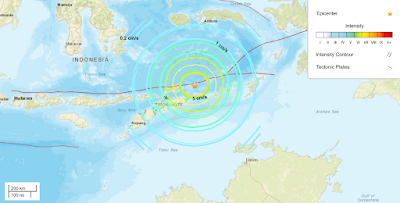
The Banda Sea is underlain by two tectonic plates, the Banda Sea Plate
and the Timor Plate; two small plates caught between the colliding
Eurasian, Pacific and Australian Plates. The Timor Plate is being
subducted beneath the Banda Sea Plate. As it sinks into the Earth the
subducting plate is being melted by the heat of the planets interior;
some of the melted material then rises through the overlying Banda Sea
Plate, fuelling volcanism on a number of islands in the region. This is
not a smooth process, and the plates frequently stick together then
break apart as the pressure builds up, leading to Earthquakes in the
region.

Follow Sciency Thoughts on Facebook.
Follow Sciency Thoughts on Twitter.