Showing posts with label Cyclones. Show all posts

Friday, 15 May 2026

At least 111 dead as high winds and dust storms sweep across Uttar Pradesh.

At least 111 people have died and another 59 have been injured as high winds and dust storms swept across Uttar Pradesh State in northern India on Wednesday 13 May 2026. The storms also damaged at least 227 homes and killed at least 200 head of livestock. Most of the injuries and fatalities have been attributed to falling trees, and in some cases walls. One man working on installing a metal roof on a warehouse building was thrown 15 m into the air when the winds tore the roof away, but miraculously survived. 

Roofing contractor Nanhe Miyan was thrown more than 15 m into the air when a section of roof he was working on came away amid high winds in Uttar Pradesh on 13 May 2026, but escaped with minor injuries. Firstpost.

High winds and dust storms are common in Uttar Pradesh in the summer months of April, May and June, when high temperatures over the arid areas to the southwest, which include the Thar Desert of Rajasthan, the Cholistan Desert of the Punjab, and the Kharan Desert of Baluchistan, can reach 45-50°C, resulting in a hot dry wind known as the 'loo' which blows over the North Indian Plain. This combination of heat and dry winds has a desiccating effect, causing trees to lose their leaves and much of the vegetation of the area to dry out and die (before blooming again with the onset of the monsoon season). It can also be very harmful to Humans, with deaths from heatstroke most common at this time of year.

However, this week's storm was a more exceptional event, bringing with it winds of over 160 km per hour, as well as heavy rainfall, something not usually associated with the loo winds. This appears to have been brought about by the interplay between a the loo wind and two cool cyclonic systems, one of which was located over northern Pakistan and Jammu and Kashmir, the other over Haryana and the northwestern part of Uttar Pradesh, according to the India Meteorological Department. The cyclonic systems had already been drawing in warm moist air from the Bay of Bengal, and when they encountered the loo winds, the moist air was forced upwards, rapidly forming cumulonimbus (thunderhead) clouds, while the dryer air wash pushed into a downdraught, leading to much higher wind speeds. 

See also...


Tuesday, 16 December 2025

Tapanuli Orangutans brought closer to extinction by Cyclone Senyar.

The Tapanuli Orangutan, Pongo tapanuliensis, is thought to have moved significantly closer to extinction after Cyclone Senyar passed across Sumatra on 25 November 2025. The species, which was only discovered in 2017, is considered to be the world's rarest Ape, with a population of about 800 all living within an area of less than 1000 km² in North Sumatra. It is considered to be Critically Endangered under the terms of the International Union for the Conservation of Nature's Red List of Threatened Species.

A male Tapanuli Orangutan, Pongo tapanuliensis. Maxime Aliaga/Sumatran Orangutan Conservation Program.

Cyclone Senyar caused more than 1000 mm of rain to fall in a day in parts of North Sumatra, triggering a series of catastrophic floods and landslides which killed over a thousand people on the island. The three districts where the species is found, North, Central, and South Tapanuli, have been particularly badly hit, with satellite images showing that between 48 and 72 km² of the forest inhabited by Tapanuli Orangutans has been destroyed, according to Erik Meijaard of Borneo Futures, who has been studying the storm's impact on the Apes. This could potentially equate to between 33 and 55 Orangutans, or between 6.2% and 10.5% of the total population.

So far, only a single dead Orangutan has been found, leading to the possibility that the Apes may have been able to escape the area before the worst of the event, although this is not typical Orangutan behaviour; they usually seek the nearest shelter and attempt to wait out large storms. Even should this have been the case, the storm appears to have destroyed large areas of their native habitat, including food sources, which makes it likely that more Orangutans will be lost in the near future. 

A dead Tapanuli Orangutan found amid storm debris in the village of Pulo Pakkat, North Sumatra, following the passage of Cyclone Senyar. Decky Chandra/The Guardian.

The population was already considered to be threatened by the expansion of mining, hydropower projects and palm oil plantations, within their habitat, as well as a rapidly changing environment, with global warning already having led to an increase in rainfall of between 28 and 160% across Sumatra. One possible benefit to the Orangutans is that the Indonesian government has ordered a halt to all new development projects in the Tapanuli area, pending a survey of the region, which may lead to their gaining some extra long-term protection. The government has also indicated its support for forest restoration projects in the region, which could lead to an increase in the available habitat for the Apes.

The storm is also reported to have completely destroyed the Ketambe Research Station, within the Gunung Leuser National Park in Aceh Province, which was the first specialist Orangutan research centre in the world, opened in 1971 by Dutch primatologist Herman Rijksen, and a leading centre for research into the Sumatran Orangutan, Pongo abelii, which is also considered to be Critically Endangered.

Damage caused to the Ketambe Research Station, within the Gunung Leuser National Park by Cyclone Senyar. American Association of Zookeepers

See also...

Tuesday, 2 December 2025

Over 1000 people thought to have died in Indonesia, Malaysia, and Thailand as a result of Cyclone Senyar.

At least 1000 people are thought to have died, with more than 2700 more known to have been injured and more than 500 still missing after Cyclone Senyar swept across Sumatra and Peninsula Malaysia on 26-28 November 2025. The storm formed as a tropical depression in the Strait of Malacca on 22 November 2025, intensifying to become a tropical cyclone before making landfall on the northern part of Sumatra at about midnight on 26 November 2025. The storm moved southwards along the coast of North Sumatra, before sweeping back across the Strait of Malacca to make landfall on Peninsula Malaysia on 27 November. On 28 November the storm swept out over the South China Sea, where it dissipated several days later without making landfall again.

Flooding in Padangsidimpuan, North Sumatra on 26 November 2025. Badan Nasional Penanggulangan Bencana/Wikimedia Commons.

The passage of Cyclone Senyar resulted in at least 753 deaths on Sumatra, with a further 2600 injured and 526 people still missing, largely as a result of flooding and landslides. Over 1.2 million people on the island have been displaced because of the storm with about 3.3 million affected in some way, across the provinces of North Sumatra, West Sumatra, and Aceh. The storm is reported to have destroyed 3600 homes, and damaged a further 5800, along with 344 bridges and 324 schools.

A woman clearing mud from a house in the town of Meureudu in Aceh Province, Sumatra, following the passage of Cyclone Senyer. Hotli Simanjuntak/EPA.

The storm caused less damage in Peninsula Malaysia, where people had more time to prepare, with three fatalities, and 34 000 people evacuated from high-risk areas ahead of the storm. However, in neighbouring part of southern Thailand, flooding associated with the storm killed at least 267 people, with most of the fatalities occurring in Songkhla Province, according to government figures; although some sources have accused the government of downplaying the size of the disaster, with suggestions that more than 1000 people may have died in Songkhla Province alone. In addition, at least 102 people were injured, with two homes destroyed and 1074 damaged, along with 228 roads, 12 bridges, 41 schools and 38 temples. The city of Hat Yai in Sonhkla Province received 372 mm of rain on 21 November, more than is typical for the entire month of November, and more rain than has fallen on the city in a single day in 300 years of records.

Flooding in Songkhla Province, southern Thailand, on 26 November 2025. AP.

Tropical storms, called Cyclones in the Indian Ocean and South Pacific, are caused by solar energy heating the air above the oceans, which causes the air to rise leading to an inrush of air. If this happens over a large enough area the inrushing air will start to circulate, as the rotation of the Earth causes the winds closer to the equator to move eastwards compared to those further away (the Coriolis Effect). This leads to tropical storms rotating clockwise in the southern hemisphere and anticlockwise in the northern hemisphere. These storms tend to grow in strength as they move across the ocean and lose it as they pass over land (this is not completely true: many tropical storms peter out without reaching land due to wider atmospheric patterns), since the land tends to absorb solar energy while the sea reflects it.

The formation of a tropical cyclone. Natural Disaster Management.

Despite the obvious danger of winds of this speed, which can physically blow people, and other large objects, away as well as damaging buildings and uprooting trees, the real danger from these storms comes from the flooding they bring. Each drop millibar drop in air-pressure leads to an approximate 1 cm rise in sea level, with big tropical storms capable of causing a storm surge of several meters. This is always accompanied by heavy rainfall, since warm air over the ocean leads to evaporation of sea water, which is then carried with the storm. These combined often lead to catastrophic flooding in areas hit by tropical storms. 

The formation and impact of a storm surge. eSchoolToday.

However, Cyclone Senyar is unusual in that it formed in a part of the world not usually prone to tropical storms; it is only the first such storm ever to form in the Strait of Malacca, and the second to cross these waters, after Typhoon Vamei, which formed in the South China Sea in 2001, and crossed Peninsula Malaysia from east to west. This is because the Strait of Malacca is close to the equator, an area where it was once thought that tropical storms could not form, as the Coriolis Force is not strong enough. However, warming global sea temperatures appear to be making this possible, as more heat is effectively more energy, and this is the fifth such near-equator storm of 2025. This means that communities in these areas are not as used to tropical storms as communities in areas where they are a long-standing problem, and infrastructure has not typically been built with large storms in mind, greatly increasing the damage and casualties caused when they appear.

See also...

Wednesday, 6 December 2023

Nine people dead after Cyclone Michuang makes landfall in Andhra Pradesh.

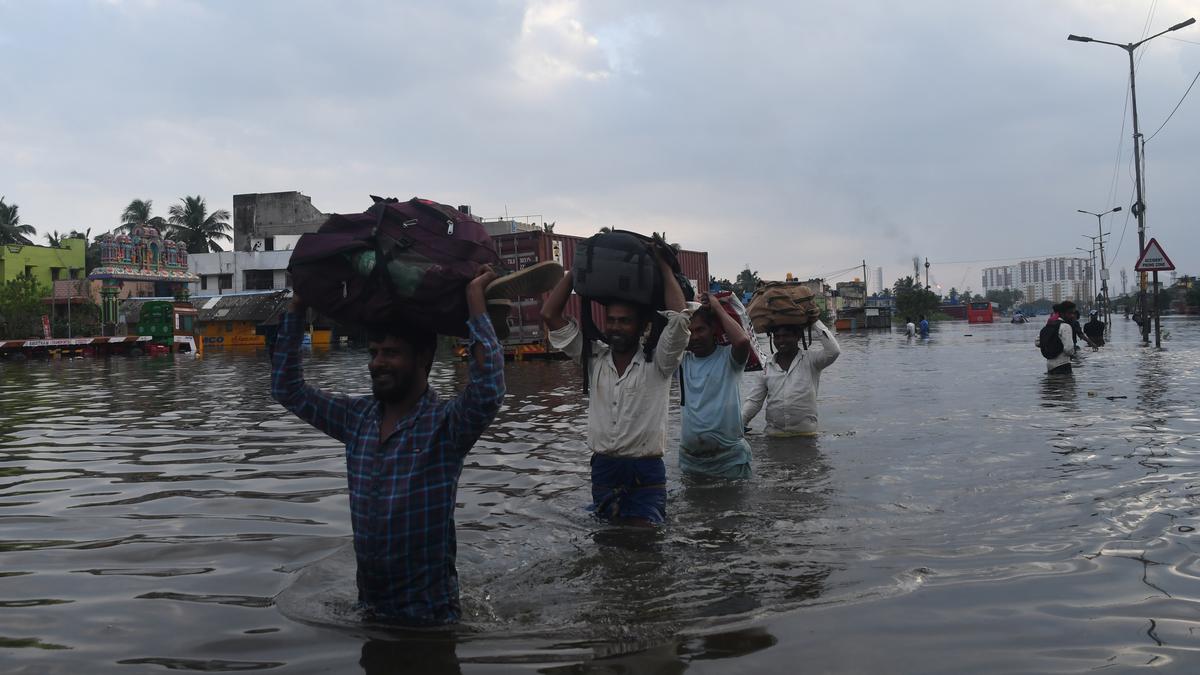
Nine people have been confirmed dead after Cyclone Michuang made landfall to the south of the city of Bapatla in southern Andhra Pradesh on Tuesday 5 December 2023. The storm made landfall at about 12.30 pm local time, bringing with it winds of up to 110 km per hour, and causing flooding along large parts of the coasts of Andhra Pradesh, Tamil Nadu, Telangana and Odisha. Around 9000 people were evacuated from coastal areas in Andhra Pradesh and 61 600 in Tamil Nadu. One person was killed in Andhra Pradesh, described as a four-year-old child crushed by a falling wall. In Tamil Nadu a further eight people died during the storm, including two people killed when a poultry unit collapsed in Eluru District and a police officer struck by a falling tree in the Siddavatam Forest.

Flooding in Chennai, Tamil Nadu, on Tuesday 5 December 2023.  Jothi Ramalingam/The Hindu.

Tropical storms, called Cyclones in the Indian Ocean and South Pacific, are caused by solar energy heating the air above the oceans, which causes the air to rise leading to an inrush of air. If this happens over a large enough area the inrushing air will start to circulate, as the rotation of the Earth causes the winds closer to the equator to move eastwards compared to those further away (the Coriolis Effect). This leads to tropical storms rotating clockwise in the southern hemisphere and anticlockwise in the northern hemisphere. These storms tend to grow in strength as they move across the ocean and lose it as they pass over land (this is not completely true: many tropical storms peter out without reaching land due to wider atmospheric patterns), since the land tends to absorb solar energy while the sea reflects it.

The formation of a tropical cyclone. Natural Disaster Management.

Despite the obvious danger of winds of this speed, which can physically blow people, and other large objects, away as well as damaging buildings and uprooting trees, the real danger from these storms comes from the flooding they bring. Each drop millibar drop in air-pressure leads to an approximate 1 cm rise in sea level, with big tropical storms capable of causing a storm surge of several meters. This is always accompanied by heavy rainfall, since warm air over the ocean leads to evaporation of sea water, which is then carried with the storm. These combined often lead to catastrophic flooding in areas hit by tropical storms. 

The formation and impact of a storm surge. eSchoolToday.

See also...

Follow Sciency Thoughts on Facebook.

Follow Sciency Thoughts on Twitter.


Saturday, 17 June 2023

Cyclone Biparjoy makes landfall in Gujarat State, India.

Cyclone Biparjoy made landfall in Gujarat State, close to the border with Pakistan, on the evening of Thursday 15 June 2023, bringing with it sustained wind speeds of 85 km per hour (a sustained wind speed is a wind speed maintained for a minute or longer) and gusts of up to 105 km per hour. Two people are known to have died following the event, described as a father and son who entered a flooded gully in an attempt to rescue some Goats, with 22 people reported injured in India and Pakistan. A much larger number of casualties was avoided by the evacuation of about 175 000 people from coastal areas in both countries, something made possible by satellite-tracking of tropical storms, which formerly killed thousands of people in South Asia every year. 

Flooding and storm damage in the Port of Jakhau, in the Kutch District of Gujarat State, following the passage of Cyclone Biparjoy. AP.

Tropical storms, called Cyclones in the Indian Ocean and South Pacific, are caused by solar energy heating the air above the oceans, which causes the air to rise leading to an inrush of air. If this happens over a large enough area the inrushing air will start to circulate, as the rotation of the Earth causes the winds closer to the equator to move eastwards compared to those further away (the Coriolis Effect). This leads to tropical storms rotating clockwise in the southern hemisphere and anticlockwise in the northern hemisphere. These storms tend to grow in strength as they move across the ocean and lose it as they pass over land (this is not completely true: many tropical storms peter out without reaching land due to wider atmospheric patterns), since the land tends to absorb solar energy while the sea reflects it.

The formation of a tropical cyclone. Natural Disaster Management.

Despite the obvious danger of winds of this speed, which can physically blow people, and other large objects, away as well as damaging buildings and uprooting trees, the real danger from these storms comes from the flooding they bring. Each drop millibar drop in air-pressure leads to an approximate 1 cm rise in sea level, with big tropical storms capable of causing a storm surge of several meters. This is always accompanied by heavy rainfall, since warm air over the ocean leads to evaporation of sea water, which is then carried with the storm. These combined often lead to catastrophic flooding in areas hit by tropical storms. 

The formation and impact of a storm surge. eSchoolToday.

See also...

Follow Sciency Thoughts on Facebook.

Follow Sciency Thoughts on Twitter