The appearance of Middle Palaeolithic stone tool industries is generally associated with the spread of Anatomically Modern Humans out of Africa and into areas of Eurasia previously occupied by other Hominins. Thus, these stone tools are considered important indicators for the spread of Anatomically Modern Humans in areas where actual fossil evidence is absent. A large number of Middle Palaeolithic sites are known from India, with age ranges dating from about 350 000 to about 40 000 years ago. Efforts have been made to subdivide this long time period into early, middle, and late phases based upon the technology used, but it is unclear if this represents an accurate reflection of cultural development in the region, or local variations in tool selection from a common cultural kit which persisted over the whole period.
While in many parts of India, Middle Palaeolithic sites have been known since the mid-nineteenth century, the first such localities in Odisha State were not discovered until the 1960s-70s, when a series of Middle Palaeolithic sites were uncovered in the Brahmani, Baitarani, and Sabarnarekha river drainage systems in the north of the state. Subsequent research uncovered several more sites in the 1980s, but since this time little archaeological work on Middle Palaeolithic sites has been carried out in this area.
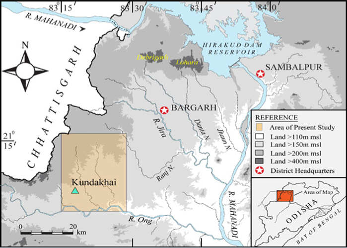
Over the last decade a series of archaeological investigations in the Bargarh Uplands have uncovered a series of Late Acheulian-Middle Palaeolithic sites, within the area 20-25 km to the south of the Debrigarh-Lohara Massif, with stone tools made primarily from quartzite, chert, and quartz derived from the massif. Subsequent investigations in the southwestern Bargarh Uplands uncovered a series of Middle-Late Palaeolithic and Microlithic (Mesolithic) sites, suggesting persistent inhabitancy of this region throughout the Middle-Late Pleistocene. One of the most important sites uncovered during these surveys is at Kundakhai, a site located on a inselberg (hill of volcanic rock), which appears to have served as a manufacturing site for Middle Palaeolithic tools.
The study area in the Southern part of Bargrh upland in the middle course of the River Ong. Behera & Barik (2022).
The site is located on a flank of the hill, at an altitude of 204 m above sealevel, about 1.5 km to the south of the village of Kundakhai. The hill itself rises to 217 m above sealevel, and is surrounded by agricultural land. Extensive investigations yielded no further archaeological material within the area, although the artefacts found come from an exposure where an Earth road joins a main road, and it is possible that further material was lost during the construction of the road.
Artefact scatters found on the foothill of the sampled area of the Kundakhai hill. Here some of the artefacts are found embedded in a deposit of coarse clast in a lateritic matrix. Behera & Barik (2022).
The hill is largely comprised of dykes of silicified rock which intruded into a (now largely eroded away) granite. The hill has only a sparse covering of vegetation, and several large boulders, with derived weathering products, are visible at the top. A dense scatter of Middle Palaeolithic tools was visible on the surface beside the junction between the roads, with subsequent investigations revealing the presence of more tools within a layer exposed by the road cut, which comprised angular cobbles within a laterite matrix.
An exposed section on the southern flank of the Kundakhai hill showing artefacts embedded in matrix of secondary
laterite with coarse clast/hill cobbles. Behera & Barik (2022).
A few artefacts were also found on the top of the hill, and the the flank beneath it, although the majority were found by the roadcut at the hill's base. Artefacts were collected from across the site by walking the surface and recording their position with a GPS unit.
A view of the top of the Kundakhai hill with exposed bedrocks of huge, silicified boulders. Behera & Barik (2022).
The most common lithic artefacts were wastage (waste material produced during tool manufacture), which formed 35.8% of the material present, and debitage (flake blades produced by the reduction of a core), which represented 32.67% of the total material. This was followed in abundance by cores (15.87% of the material), shaped tools (15.41%), and hammers with battering marks (0.23%).
Despite probably having been washed down the hill, and disturbed by the recent road-making process, most of the artefacts are intact, with broken tools largely represented by blades broken close to their tips. Only three of the 137 cores found were broken.
The majority of the artefacts found at Kundakhai are made from rock identical to the silicious boulders which outcrop on the top of the hill, and these boulders show marks made by hammering, strongly supporting the idea that the hill was a manufacturing site. A smaller number of tools (about 6%) are made from milky quartz, chert, or quartzite, apparently imported from the banks of the River Ong, 7-8 km away, and its tributaries the Ghensali and Utali, with all material originating less than 25 km from the site.
A closer view of some of the silicified bedrocks on the top of the hill showing removal of large flakes with hard hammer percussion. Behera & Barik (2022).
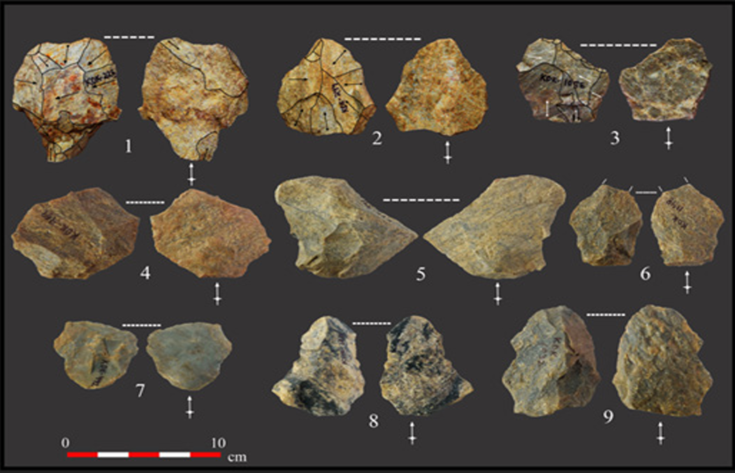
Eight different types of core were identified at the Kundakhai site, which Bahera and Barik identify as Levallois cores, discoidal cores, non-Levallois flake cores, flake-blade cores, flake-bladelet cores, blade-bladelet cores, blade cores, and bladelet cores. Although there are a few blade-bladelet cores which were probably used as tools in their own right, the majority of these cores would have been used to produce flakes for use as blades (it is possible to tell a core has been used in this way by the scars on the blank removal surface). The majority of the cores are oval in shape, but highly variable in size - with the exception of the Levallois cores, which are symmetrical in shape and consistent.
Different Levallois core from the sampled area-Recurrent Levallois Core (1)-(4), Preferential Levallois Core (5)-(6), Discoidal Core (7)-(8). Behera & Barik (2022).
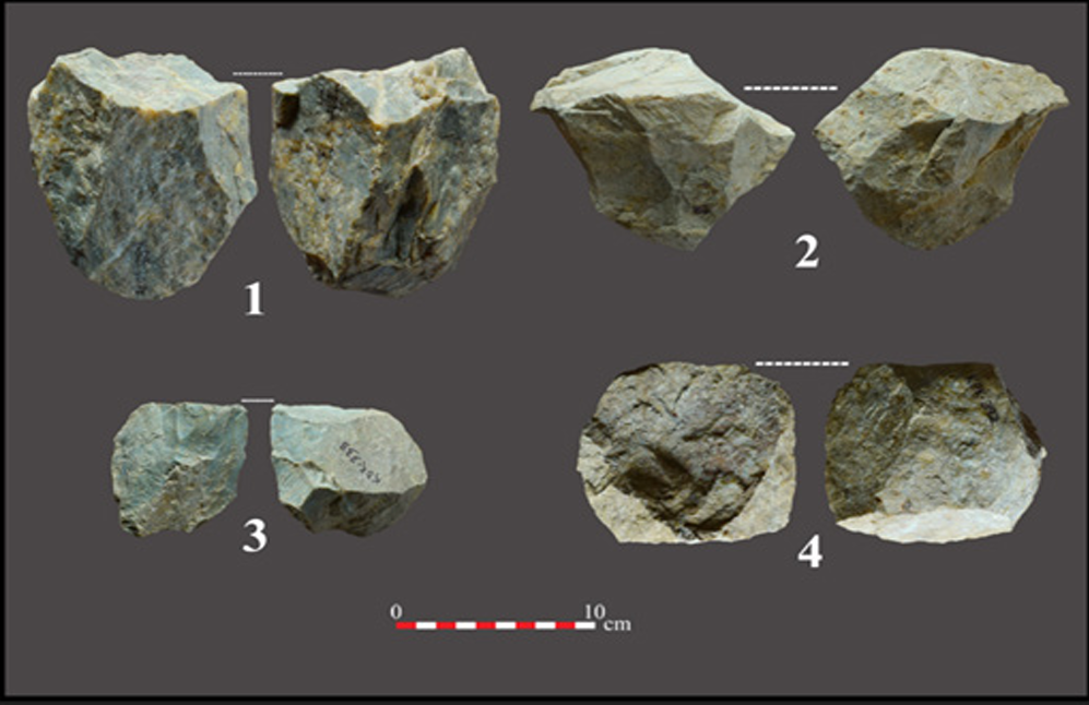
The site did not yield any cores with rounded cortical surfaces, which are formed by the working of large pebbles and cobbles from riverbeds, suggesting that such rocks were not used. The most abundant cores were the Levallois cores, followed by discoidal cores. Of the remainder, the most common type were single platformed cores, followed by opposed platform opposed face cores, then opposed platform same face cores.
Different non-Levallois core from the sampled area-Flake/Blade Core Single Platform (1), Opposed Platform Opposite Face Flake Core (2), Single Platform blade & Bladelet Core (3), Single platform Flake Core (4). Behera & Barik (2022).
The debitage material comprises 197 flakes, 20 blades, and two bladelets. About 30% of this material has been broken, mostly near the tip, and almost all of it apparently during manufacture rather than use. The commonest flake type are Toth's Type-VI (so named because the classification system was developed by American archaeologist Nicholas Toth), with the remainder being Toth's Type-II-IV. Levallois flakes mostly range from 40 to 60 mm in length, while non-Levallois flakes mostly range from 20 to 50 mm in length. No flakes measure longer than 90 mm.
The large thick flakes hammered from the rocks at the top of the hill appear to have been used to make cores for blank production; more than half of the cores present have been made from such flakes. These cores are most commonly unfaceted (44.79% of the time), followed by faceted (23.44%), dihedral (8.33%), and punctiform (2.6%).
Excluding the Levallois flakes, the approach to tool-making appears to have been quite flexible, resulting in a wide variety of flake and core shapes, and suggesting tools were probably being made specifically to the job in hand. Two Kombewa flakes and two possible Kombewa flakes were found among the assemblage, although no Kombewa cores were found.
The vast majority of finished tools present at the Kundakhai site are made from modified flakes, predominantly non-Levallois flakes, but with some tools made from Levallois flakes, as well as a small number of modified cores, and a single, unfinished handaxe. The majority (61%) of the modified flakes are scrapers, with some notched tools (thought to have been used in woodworking), a few of which are of the Clacktonian type.
 Different types of tools made on Silicified stone. (1) Side Scrapper, (2) Levallois Point, (3) Denticulate, (4) Concave Side Scrapper, (5)-(7) & (9)-(11) Blades, including (5) Offset Dihedral Burin, (7) Partially baked & Unilaterally Retouched on Ventral Side, (8) Bladelet, (9)-(11) Partially retouched Laterals. Behera & Barik (2022).
Awls and burins are both also present, sometimes in combination with scrapers or notched tools. Some points are present, mostly typical and atypical Levallois points, but with one retouched point and one tanged point also found; the tanged point is bilaterally prepared, but lacks the convergent distal end typical of the Indian Middle Palaeolithic.
(1) Pseudo Levallois Tanged point, (2) Levallois Point, (3) Transverse Scrapper. (4)-(8) Levallois Flakes, (9) Non Levallois Bidirectional Flake. Behera & Barik (2022).
The single handaxe present at the site is made from a piece of greyish-black chert, clearly not sources from Kundakhai hill, and probably sourced from the Ghensali or Utali streams, where similar clasts are present having been carried from the source of the streams in the Jhanj-Malaikhaman hills. The axe is 193.83 mm in length and 83.25 mm in width, and appears unfinnished, with the but being unmodified and the tip broken off, possibly suggesting that the attempt at tool-making was abandoned.
Hand Axe. Behera & Barik (2022).
A number of archaeological sites have previously been found in the Northern Bargarh Uplands, yielding Late Acheulian-Middle Palaeolithic tools. One of these, Torajunga, has produced a particularly extensive Middle Palaeolithic tool set, including medium sized handaxes and cleavers, scrapers, notched tools, denticulates, spheroids, and tanged points. The other sites contain smaller selections of tools from the same kit, and are often exposed at the surface, and in less than pristine condition.
 Hammer Stone with use marks. Behera & Barik (2022).
The Kundakhai site was discovered during a systematic survey of the Southern Bargarh Uplands, which aimed to find similar sites to those already known to the north. This survey yielded several sites with small surface scatterings of Middle Palaeolithic tools, and a few examples of Early Palaeolithic material, as well as mapping outcrops of rock likely to have been useful to Palaeolithic toolmakers.
The majority of the tools present at Kundakhai appear to have been made at the site from the silicious rock which outcrops here, with only a very small proportion made from imported chert or quartzite. The site lacks many of the tools present in the Northern Bargarh Uplands, including small to medium sized hand axes and cleavers, picks, polyhedrons, well-organised blade core technology, well-made tanged points, but shares other features, most notably Levallois tools, discoidal cores, scrapers and denticulate tools, all of which are also well known from Middle Palaeolithic sites elsewhere in India.
The apparently long length of the Indian Middle Palaeolithic has led to attempts to divide it into phases. Typically three phases are used, with the first still retaining many Acheulian tools, the second based around a core-reduction technology, and the third more focused on blades, although the evidence that this is an accurate reflection of change over time in the region is absent. If this scheme is used, then the assemblage at Kundakhai, dominated by cores and core-derived tools, belongs firmly in the second phase, although this assessment cannot be used to guess the age of the site.
See also...


%20(1)%20(1).png)