Showing posts with label Tamil Nadu. Show all posts

Sunday, 7 December 2025

Number of dead in Sri Lanka following Cyclone Ditwah has now reached 619.

The number of people known to have died after Cyclone Ditwah made landfall in Sri Lanka on 28 November 2025 has reached 219, making the storm the worst natural disaster to befall the nation since the Boxing Day Tsunami of 2004. A further 209 people are still recorded as missing since the storm, with 18 people listed as having been injured. About 2 million people (almost 10% of the population) are thought to have been affected in some way by the storm, with 4071 homes destroyed and 71 121 damaged by flooding and landslides, as has much of the island's infrastructure and agricultural land. Authorities in Sri Lanka are warning that there is still a high risk of landslides, as monsoon rains fall onto already soaked hillside soils. Landslides are a common problem after severe weather events, as excess pore water pressure can overcome cohesion in soil and sediments, allowing them to flow like liquids. Approximately 90% of all landslides are caused by heavy rainfall.

Flooding in the Gampaha District of Colombo, Sri Lanka, following the passage of Cyclone Ditwah. Incept Change/UNICEF

Cyclone Ditwah was first detected as a tropical depression off the south coast of Sri Lanka by the Indian Meteorological Department on 26 November 2025. This depression increased in strength, becoming first a deep depression and then a cyclonic storm of 27 November. It crossed over Sri Lanka on the night of 28-29 November, bringing catastrophic levels of rainfall, then moved out over the Bay of Bengal. The storm continued to move northwatds along the Coromandel Coast, in the process bringing more flooding to the states of Tamil Nadu and Puducherry, which led to three Human and 149 Cattle deaths, as well as flooding much farmland, and damaging or destroying 234 homes. The storm weakened as it moved northward, eventually making landfall in Tamil Nadu as a low pressure system on 3 December.

Flood damage beside the Mahaweli River in Kandy, Sri Lanka, following the passage of Cyclone Ditwah. Reuters.

Tropical storms are caused by the warming effect of the Sun over tropical seas. As the air warms it expands, causing a drop in air pressure, and rises, causing air from outside the area to rush in to replace it. If this happens over a sufficiently wide area, then the inrushing winds will be affected by centrifugal forces caused by the Earth's rotation (the Coriolis effect). This means that winds will be deflected clockwise in the northern hemisphere and anti-clockwise in the southern hemisphere, eventually creating a large, rotating Tropical Storm. They have different names in different parts of the world, with those in the Indian Ocean being referred to as cylcones.

The structure of a tropical cyclone. Wikimedia Commons.

Despite the obvious danger of winds of this speed, which can physically blow people, and other large objects, away as well as damaging buildings and uprooting trees, the real danger from these storms comes from the flooding they bring. Each drop millibar drop in air-pressure leads to an approximate 1 cm rise in sea level, with big tropical storms capable of causing a storm surge of several meters. This is always accompanied by heavy rainfall, since warm air over the ocean leads to evaporation of sea water, which is then carried with the storm. These combined often lead to catastrophic flooding in areas hit by tropical storms. 

The formation and impact of a storm surge. eSchoolToday.

Cyclone Ditwah is not considered to be a large storm, but has caused extensive damage due to the large volumes of water it dropped onto Sri Lanka. It has been estimated that the cost of repairing the infrastructure damage caused by the storm will be about US$7 billion, coupled with a loss of income from the destruction of the agricultural and tourism sectors. Sri Lanka had a gross domestic product of about US$99 billion in 2024, but suffers from high levels of government debt. In 2023 the country was obliged to borrow US$3 billion from the International Monetary Fund to help with debt servicing, after a period of economic contraction in 2022 which led inflation to reach 57%. 

Sri Lanka is considered to have met the first United Nations' Millennium Development Goal, halving extreme poverty between 1990 and 2015, but 12% of the country is still considered to be living below the extreme poverty line, and 53% below the poverty line. While the country has made progress on growing its economy and lifting its people out of poverty, climatic events such as Cyclone Ditwah can set progress back significantly, and are predicted to become more common as the climate warms. Countries in the Global South are predicted to be particularly badly impacted by effects of global warming, despite having done little to cause the crisis; Sri Lanka is considered to have produced about 0.03% of global greenhouse gas emissions since the onset of the Industrial Revolution.

See also...

Saturday, 2 March 2024

Skeleton of Neolithic child uncovered in Tamil Nadu, India.

Archaeologists from the Department of Ancient History and Archaeology at the University of Madras, have uncovered the skeleton of a child thought to be 9-11 years old, based upon the presence of a deciduous first molar in the mandible, at a Neolithic site in the village of Chettimedu near Chengalpattu in Tamil Nadu. The body was orientated north-south with the head to the north, and facing to the west, a practice which began in the Neolithic and persisted into the Early Historic Period.  It is thought to date to between 3000 BC and 2500 BC and was buried alongside a broken pot in the Burnished Grey Ware style, which is typical of the Late Neolithic in southern India. 

The pot beside the skeleton is typical of neolithic period. Many shreds of burnished red ware and burnished grey ware belonging to the same period were also found at the burial site. New Indian Express.

While typical of the southern Indian Neolithic, Burnished Grey Ware is actually rare in Tamil Nadu State, having been found only at the Chettimedu site and at Valasai in Vellore District, 370 km to the southwest. As well as the Burnished Grey Ware, examples of Burnished Red Ware, Black and Red Ware, All-black Ware, Red Slipped Ware, Red Ware and Coarse Red Ware have been found in different layers at the site, with pottert from the uppermost layers having some writing upon it, implying a sequence of occupation lasting through the Neolithic and Iron Age into the Early Historic Period. Some bricks also thought to date to the early historic period were also found. 

The site at Chettimedu was first identified in 2019, by construction workers digging foundations for a new project. The initial material uncovered included incised potsherds, earrings made of baked clay, and iron arrowheads, associated with the Iron Age-to-Early Historic Period Sangam Culture, which lasted from about 600 BC to about 300 AD. Subsequent excavations have uncovered material from a succession of earlier periods, including some pottery which may be associated with the Chalcolithic Malwa Culture of central India.

See also...

Wednesday, 17 January 2024

Cigaritis meghamalaiensis: A new species of Lycaenid Butterfly from the southern Western Ghats of India.

Lycaenid Butterflies or 'Blues' are a widespread and highly successful group of Lepidopteran Insects, noted for their blue or metallic colouring. With about 6000 known species, Lycaenids are found on all continents and comprise about 30% of all described Butterfly species. The group is particularly notable for its relationship with Ants, with the females of many species laying their eggs in or near to Ant nests, and the young of many species being able to induce the Ants to feed them while they mature within the nest. This relationship appears to have mutualistic roots, with some members of the group having larvae which are guarded by the Ants while they feed, and which produce a sugar-rich honeydew which the Ants consume. Silverlines, Cigaritis spp., are a genus of Lycaenid Butterflies found across Africa, South and Southeast Asia.

In a paper published in the journal Entomon on 31 December 2023,  Ramasamy Kamaya Naicker of  Saptur Palace and the Vanam Trust, Sujitha Prabhakaran Chandrika of the Department of Zoology at the University of Kerala, Baiju Kochunarayanan of Sreerangam, Jebine Jose of Kaduvathookil House, Manoj Kripakaran of Shyladhri, Rajkumar Chidambaram Palaniappan, also of the Vanam Trust, Vinayan Padmanabhan Nair of Nethaji Housing Colony, Kalesh Sadasivan of Greeshmam and the Travancore Nature History Society describe a new species of Cigaritis from the southern Western Ghats of India.

The new species is named Cigaritis meghamalaiensis, where 'meghamalaiensis' means 'from Meghamalai' , in reference to the region where it was discovered; the name 'Meghamalai' means 'cloud mountain', so the name also refers to the subtropical montane cloud forests where the species is found. The species was first observed at high elevations within the Periyar Tiger Reserve in Kerala State, and subsequently also found in the adjoining Meghamalai Mountain Range of Tamil Nadu.

Cigaritis meghamalaiensis Field images of males, females and seasonal forms. (A) Male, typical colouration; (B( female, typical colouration; (C) male upperside; (D) female upperside; (E) dry season male underside; (F) dry season female underside; (G) mating; (H) oviposition. Ramasamy Naicker in Naicker et al. (2023).

Males of Cigaritis meghamalaiensis have forewings that are black on the upper side with extensive metallic blue markings, and hindwings that are grey with blue markings. In females the forewings are grey with metallic blue markings and the hindwings are a lighter grey with blue markings. In both sexes the undersides of the wings in both sexes are a pale pinkish brown with pinkish orange markings.

Cigaritis meghamalaiensis. Early stages, larval pens, and attending Ants. (A) Freshly laid egg; (B) larvae being attended by Crematogaster Ants inside the larval pen; (C) intermediate instar larvae and its attending Ant; (D) larval pen under the bark of a shola tree opened to reveal the walls (white arrows), and two larvae inside it marked 1 and 2  (blue arrows). Kalesh Sadasivan & Jebin Jose in Naicker et al. (2023).

Butterflies were observed flying between December and June, although they were surprisingly reluctant to the wing, making them easy prey to Spiney Lizards and other predators. They were found only on the fringes of subtropical evergreen forests. Females were observed to fly around trees with populations of predatory Acrobat Ants, Crematogaster spp.. Mating was observed in April, and eggs were laid between April and December, on the bark of trees and shrubs such as Neolitsea spp. and  Clerodendrum infortunatum, always in the presence of Crematogaster wroughtonii Ants, either in dark crevices on the stems or directly in the Ants' nests.

Cigaritis meghamalaiensis, habitat and host plants. (A) Sub-tropical Evergreen forests of Meghamalais (1400m above sealevel); (B) Neolitsea cassia, a host tree; (C) typical climate inside the misty cloud forests; (D) female ovipositing inside Crematogaster nest on Clerodendrum infortunatum. Ramasamy Naicker, Kalesh Sadasivan, & Jebin Jose in Naicker et al. (2023).

Larvae were observed in 'pens' under the bark of the trees, where they were tended by Crematogaster wroughtonii Ants. These pens each contained 3-4 larvae, and appeared to be constructed specifically by the Ants, away from their own nests. This suggests that the relationship is mutual rather than parasitic, with the Ants gaining some benefit from the relationship, possibly consuming some product produced by the caterpillars. 

See also...


Wednesday, 6 December 2023

Nine people dead after Cyclone Michuang makes landfall in Andhra Pradesh.

Nine people have been confirmed dead after Cyclone Michuang made landfall to the south of the city of Bapatla in southern Andhra Pradesh on Tuesday 5 December 2023. The storm made landfall at about 12.30 pm local time, bringing with it winds of up to 110 km per hour, and causing flooding along large parts of the coasts of Andhra Pradesh, Tamil Nadu, Telangana and Odisha. Around 9000 people were evacuated from coastal areas in Andhra Pradesh and 61 600 in Tamil Nadu. One person was killed in Andhra Pradesh, described as a four-year-old child crushed by a falling wall. In Tamil Nadu a further eight people died during the storm, including two people killed when a poultry unit collapsed in Eluru District and a police officer struck by a falling tree in the Siddavatam Forest.

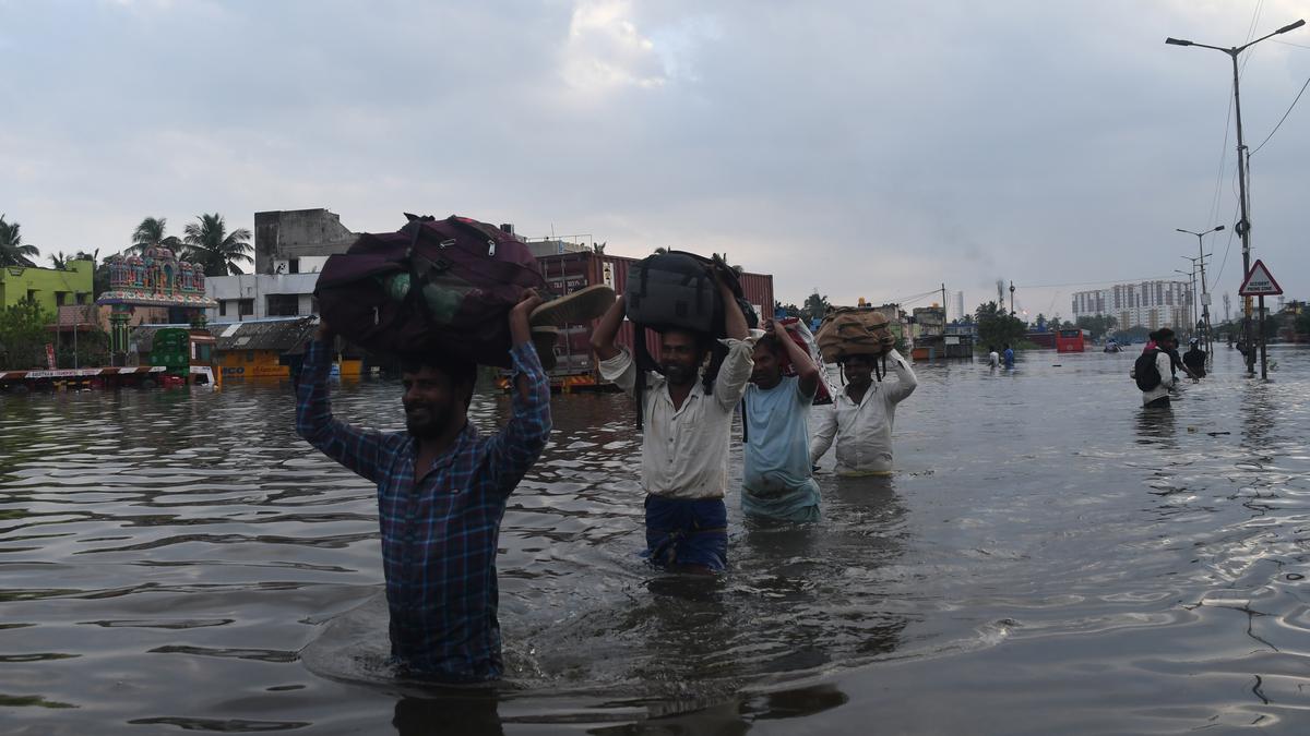
Flooding in Chennai, Tamil Nadu, on Tuesday 5 December 2023.  Jothi Ramalingam/The Hindu.

Tropical storms, called Cyclones in the Indian Ocean and South Pacific, are caused by solar energy heating the air above the oceans, which causes the air to rise leading to an inrush of air. If this happens over a large enough area the inrushing air will start to circulate, as the rotation of the Earth causes the winds closer to the equator to move eastwards compared to those further away (the Coriolis Effect). This leads to tropical storms rotating clockwise in the southern hemisphere and anticlockwise in the northern hemisphere. These storms tend to grow in strength as they move across the ocean and lose it as they pass over land (this is not completely true: many tropical storms peter out without reaching land due to wider atmospheric patterns), since the land tends to absorb solar energy while the sea reflects it.

The formation of a tropical cyclone. Natural Disaster Management.

Despite the obvious danger of winds of this speed, which can physically blow people, and other large objects, away as well as damaging buildings and uprooting trees, the real danger from these storms comes from the flooding they bring. Each drop millibar drop in air-pressure leads to an approximate 1 cm rise in sea level, with big tropical storms capable of causing a storm surge of several meters. This is always accompanied by heavy rainfall, since warm air over the ocean leads to evaporation of sea water, which is then carried with the storm. These combined often lead to catastrophic flooding in areas hit by tropical storms. 

The formation and impact of a storm surge. eSchoolToday.

See also...

Follow Sciency Thoughts on Facebook.

Follow Sciency Thoughts on Twitter.


Tuesday, 2 August 2022

First recording of a Light-mantled Albatross from Asia.

Albatrosses, Diomedeidae, are large-bodied Seabirds with an almost entirely Southern Hemisphere distribution. The Light-mantled Albatross, Phoebetria palpebrata, is generally restricted to Southern Ocean. This species is currently considered Near Threatened under the terms of the International Union for the Conservation of Nature's Red List of Threatened Species, largely due to their being caught as bycatch by longline fisheries. The global population of Light-mantled Albatrosses was last estimated at 21 600 breeding pairs in 1998.

In a paper published in the Journal of Threatened Taxa on 26 July 2022, Hameed Byju of the Centre of Advanced Study in Marine Biology at Annamalai University, and Natarajan Raveendram of the Iragukal Amritha Nature Trust record of a Light-mantled Albatross from Rameswaram Island, off the southeast coast of Tamil Nadu State, India, which is, to the best of their knowledge, the first recording of this Bird from anywhere in Asia.

The Albatross was first spotted on 8 September 2020, in on Anthoniyapuram Beach by local fishermen, who informed the Tamil Nadu Forest Department as the Bird appeared weak and unable to fly. The Albatross was collected and allowed to rest, before flying away. It would not take food.

A Light-mantled Albatross, Phoebetria palpebrata, on Anthoniyapuram Beach on Rameswaram Island, Tamil Nadu, on 8 September 2022. Francis Aravind in Byju & Raveendram (2022).

See also...

Follow Sciency Thoughts on Facebook.

Follow Sciency Thoughts on Twitter.


Sunday, 16 May 2021

Two dead in Kerala as Cyclone Tauktae moves up the west coast of India.

Two people have died in Kerala State, India, as Cyclone Tauktae moved up the western Indian coast over the past two days, bringing with it high winds, heavy rainfall, and storm surges. The storm has caused widespread disruption, flooding low lying areas, uprooting trees and downing power lines, but has so far caused relatively few casualties to the evacuation of thousands of people from areas expected to be the worst hit (before the introduction of this practice, tropical storms making landfall in India regularly killed thousands of people). So far the storm has passed along the shores of Tamil Nadu and Kerala states, and is expected to pass Goa and move on to Maharashtra today, eventually making landfall in Gujarat on Tuesday 18 May 2021.

 
A storm surge near Mangaluru, in Karnataka State, India, on Saturday 15 May 2021. Press Trust of India.

Tropical storms, called Cyclones in the Indian Ocean and South Pacific, are caused by solar energy heating the air above the oceans, which causes the air to rise leading to an inrush of air. If this happens over a large enough area the inrushing air will start to circulate, as the rotation of the Earth causes the winds closer to the equator to move eastwards compared to those further away (the Coriolis Effect). This leads to tropical storms rotating clockwise in the southern hemisphere and anticlockwise in the northern hemisphere. These storms tend to grow in strength as they move across the ocean and lose it as they pass over land (this is not completely true: many tropical storms peter out without reaching land due to wider atmospheric patterns), since the land tends to absorb solar energy while the sea reflects it.

 
A rescue team carries a woman from a flooded building in Kochi, Kerala, on Saturday 15 May 2021. NDTV.

Despite the obvious danger of winds of this speed, which can physically blow people, and other large objects, away as well as damaging buildings and uprooting trees, the real danger from these storms comes from the flooding they bring. Each drop millibar drop in air-pressure leads to an approximate 1 cm rise in sea level, with big tropical storms capable of causing a storm surge of several meters. This is always accompanied by heavy rainfall, since warm air over the ocean leads to evaporation of sea water, which is then carried with the storm. These combined often lead to catastrophic flooding in areas hit by tropical storms.

 
The path and strength of Cyclone Tauktae. Thick line indicates the past path of the storm (till 6.00 am GMT on Sunday 16 May 2021), while the thin line indicates the predicted future path of the storm, and the dotted circles the margin of error 12, 24, 36, 48 and 72 hours ahead. Colour indicated the severity of the storm. Tropical Storm Risk.

 
The formation and impact of a storm surge. eSchoolToday.

See also...


Follow Sciency Thoughts on Facebook.

Follow Sciency Thoughts on Twitter.