Showing posts with label Fortifications. Show all posts

Tuesday, 16 January 2024

Investigating the walled oasis at Khaybar, Northwest Arabia.

Walled oases appear to have been a key part of the development of early settled societies on the Arabian Peninsula. Unlike other defensive systems, such as isolated towers, fortresses, or even walled cities, walled oases comprised an extensive system of defences enclosing an entire agricultural system, and marking a boundary between this managed farmland and the surrounding desert. Two such walled oases, Tayma and Qurayyah, have been familiar to archaeologists for a long time, and been the subject of numerous studies. However, recent examination of satellite images of the region has exposed a series of previously unknown walls around other oases, including Khaybar, Huwayyit, Dumat al-Jandal, Hait, Al-Wadi, Al-Ayn, and al-Tibq. This process of urbanization and oasis protection appears to have begun during the Bronze Age and persisted into the Iron Age, paying a major role in the appearance of the  caravan kingdoms.

Khaybar has a pre-Islamic period fortress located on a mesa at the centre of the great wadis which dominate the site, but a wall enclosing the entire oasis had not previously been observed or even suspected. The walls are spread over a wide area, and for the most part have been dismantled to the point at which they are hard to recognise. The area is rugged, and made up largely of basalt rock with almost zero sedimentation, so that any and all archaeological remains sit on the surface. This has created a lunar landscape, dotted with archaeological remains from a wide range of periods, including desert kites, mustatils, funerary avenues and dense necropolises, encampments, forts, plot walls, a range of less identifiable structures. To date, about 16 000 such structures have been counted within the 56 km² of land which constitutes the oasis. Determining that dismantled and fragmentary walls scattered over a wide area formed part of a single original structure requires extensive fieldwork and careful examination of the components.

In a paper published in the Journal of Archaeological Science: Reports on 10 January 2024, Guillaume Charloux, Shadi Shabo, Guillaume Chung-To, and Bruno Depreux of the French National Centre for Scientific Research, independent researcher François Guermont, Kévin Guadagnini, also of the French National Centre for Scientific Research, Thomas Therasse and  Mylène Bussy, also independent researchers, Saifa Alshilali of the Royal Commission for AlUla, Diaa Albukaai and Rémy Crassard, again of the French National Centre for Scientific Research, and Munirah AlMushawh, another independent researcher, demonstrate the presence of a defence wall around the entire Khaybar Oasis, as well as providing dating information on its construction and use.

Location map of the Khaybar walled oasis (red and white circle) and other major sites in north-western Arabia. Guillaume Charloux in Charloux et al. (2024).

Six seasons of fieldwork were carried out between October 2020 and March 2023, as part of the Khaybar Longue Durée Archaeological Project. Khaybar is about 670 m above sealevel, and is located in the Hijaz Region of Saudi Arabia, between Medina and AlUla. It was an important agricultural centre in the Early Islamic Period, with the entire oasis measuring about 8 km by 7 km. The oasis is at the confluence of three alluvial valleys, Wadi al-Suwayr/Halhal, Wadi al-Zaidiyyah, and Wadi al-Sulamah, which merge on the western side of the oasis to form the Wadi Khaybar. The wadis are cut into the surrounding Neogene-Quaternary basalt plateau, and contain a series of perched sediment beds. The first (brief) archaeological survey of the oasis was carried out in 2015. This was followed by an aerial survey by the Aerial Archaeology in Kingdom of Saudi Arabia project in 2018, with the Khaybar Longue Durée Archaeological Project beginning in 2020.

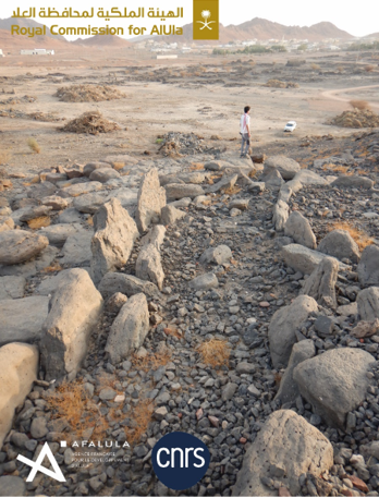
Aerial views of the dry-stone basement of the outer rampart: (A) Segment KH00911 facing south; (B) Segment KH01130 facing north; (C) Segments KH00904-KH00905 and KH00906 facing south; (D) segment KH00922. Guillaume Charloux in Charloux et al. (2024).

Charloux et al. used ArcGIS mapping software to combine aerial photography with high resolution geological maps and e architectural, archaeological and geomorphological surveys of the oasis to build up a map of the wall network. They also dug 19 test pits into sections of the remaining ramparts. 

Map of the main ramparts of Khaybar, with identification of main segment walls and location of bastions and soundings in 2021–2023. Guillaume Charloux in Charloux et al. (2024).

Charloux et al. discovered 5.9 km of previously unknown wall, 5.9 km of which are interpreted as being part of a network which once enclosed the entire oasis. There were 146 large wall segments remaining, ranging in length from a few metres to several hundred metres. The discovered walls were placed into five groups. Group A comprised aligned accretion walls 2.4-4.5 m thick, with both bastions and towers, and without any obvious discontinuity, which formed part of the enclosure surrounding the al-Natah Site. Group B walls comprised two exterior faces with a rubble in-fill, 1.4-2.4 m thick, with bastions, forming part of an inner enclosure wall. Group C walls were similar to Group B walls, but formed part of the outer perimeter enclosing the entire oasis. Group D walls are made from multiple types of masonry, are between 50 cm and 4 m thick, lack bastions, and again form part of an inner enclosure. Group E walls were smaller segments, similar in construction to Group D walls, which did not form part of any obvious larger structure.

View of the ramparts KH00905-KH00906 and a bastion KH00974 during excavation, looking west. Kévin Guadagnini in Charloux et al. (2024).

The remaining outer wall around the Khaybar oasis has a length of 5912.78 m, which is thought to represent 41% of an original wall which would have measured 14.5 km, enclosing an area of 11.8 km². The wall is interrupted by a variety of newer roads, buildings, gardens, etc., making it difficult to reconstruct the entire shape of the perimeter boundary, particularly on the southern side. 

Rampart KH00909, looking north. Charloux et al. (2024).

Seventy four bastions are still present on this outer wall, wall facing out towards the desert rather than in towards the oasis, which Charloux et al. consider to be strong evidence for the entire enclosure to have been built in a single phase of construction, albeit one which would have taken some time and been subject to subsequent additions and alterations.

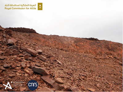
Rampart KH00911 situated on the crest (right on the picture), looking east. Guillaume Charloux in Charloux et al. (2024).

The walls of the outer perimeter are also very similar throughout their extent, most being rubble-filled, double-faced dry-stone walls, between 1.8 m and 2.4 m thick, which again supports a single interval of wall building. The walls appear to have been built in separate segments, with the thinnest section on the slopes and summits of Jabal Mushaqqar, where it is only 1.1 m thick and built of simple drystone masonry, which was apparently acceptable to the builders for this s high position along a ridge on the top of a rhyolite mountain. Earlier stone structures in the region appear to have been raided extensively for building stone.

View of the currently preserved masonry of the outer enclosure wall (rampart KH01130) facing north. Guillaume Charloux in Charloux et al. (2024).

The majority of the wall is made up of curvilinear sections which for the most part follow the contours of the plateau, with connections between these long sections crossing valleys at their narrowest points. Ramparts are between 120 m and 250 m from the cliff edge, apparently built at this distance to avoid the topological irregularities associated with the cliff. Building the wall in this way would have given good visibility over both the oasis and the surrounding desert, while enclosing the minimum amount without encroaching on the agricultural land.

Rampart KH00911 on top of the cliff, looking north. Guillaume Charloux in Charloux et al. (2024).

The height of the original walls is impossible to determine; only the stone bases of the walls remain, but there are traces of mud bricks in places, which suggests a brick superstructure existed on top of the stone wall. The highest remaining section of wall is 3 m tall, at Makidah on the southern section. Charloux et al. suggest another 2 m of brick wall may have existed on top of this, possibly with a walkway. The walls at the Tayma Oasis, have been estimated at 6 m high, with an inner enclosure which might have been 14 m high, while the walls at Dumat al-Jandal have been estimated at 6.5 m, and a section of walkway has been identified.

Rampart KH00919, with dismantled infilling, looking northeast. Guillaume Charloux in Charloux et al. (2024).

There are no contemporaneous structures attached to the outer wall, which is made of basalt and has been heavily eroded by the desert winds and runoff from the annual rains, as well as depletion due to raiding by later builders of other structures, all of which tend to make dating of any structure difficult. However, the wall is built over several older pendant tombs, some of which were also raided for stone by the wall builders. These tombs have been dated to the middle of the third millennium BC, which makes it impossible for the wall to have been built before about 2600-2200 BC. 

Rampart KH00918, looking northeast. Guillaume Charloux in Charloux et al. (2024).

Charloux et al. were able to obtain radiocarbon dates from eight charcoal samples obtained from five test pits sunk into the remaining wall segments. The oldest of these come from beneath the wall, providing a maximum age for the overlying wall segment. Other samples come from layers abutting the rampart or in the immediate vicinity of its foundation, suggesting they provide a time for the construction or first use of the wall, while other pieces come from the wall infill, which again makes it most likely they date from the time of wall construction. Finally, sone charcoal pieces come from beneath what appear to be gates in the wall, and could therefore have been deposited while the wall was in use.

Rampart KH00918, looking southwest. Guillaume Charloux in Charloux et al. (2024).

Based upon these radiocarbon dates, Charloux et al. suggest that the outer perimeter wall at Khaybar Oasis was built after 2279 BC, and probably after 2139 BC, but probably before 2201 BC and definitely before 1980 BC. The wall appears to have still been in use as late as 1741 BC and 1542 BC.

Location of dating samples on rampart KH00905 (plan on orthophotography and sections). Section 1: KH00906.002 and KH00906.004 are filling layers above ash area KH00906.005 on top of construction floor KH00906.006; Section 2: KH00905.002 is a collapse layer above a thin ash dump above fills KH00905.003 and KH00905.005 above possible construction floor KH00905.004. Guillaume Charloux, François Guermont & Kévin Guadagnini in Charloux et al. (2024).

This suggests that the Khaybar Oasis, one of the largest in Arabia, was enclosed by a perimeter wall in the Bronze Age, around 2000 BC. The appearance of such walled oases is thought to have been a key step in the evolution of urbanization in the region. The walls presumably offered protection against raids from the desert, a danger to settlements on the Arabian Peninsula in the pre-Islamic and Early Islamic Periods, but one for which evidence has been absent in the Bronze Age until now, despite the presence of Bronze Age 'Warrior Burials' in northern Arabia. Such walls may have also plaid a role in controlling the environment within the oasis, helping to prevent soils from blowing away and helping to prevent flash floods from reaching crops. The walls would also have made a symbolic statement about the ownership of the oasis, clearly delimiting a boundary between the territory inside the wall and the open desert. This would have been a powerful symbol to any desert groups seeing it, and presented a clear social identity to those within.

Dismantled bastion at the front of rampart KH00918, looking southwest. Guillaume Charloux in Charloux et al. (2024).

The size of the surrounding wall suggests that a reasonably large workforce was involved, and that local political leadership was sufficiently organized to co-ordinate such a project. It has previously been assumed that large building works like this in Bronze Age societies would have required very large numbers of workers, but recent evaluations of workloads has suggested that much smaller numbers of people might have been able to undertake large projects. Constructing the outer wall to a height of 5 m would have required the movement of 164 000 m³ of stone, and/or bricks, which Charloux et al. would have required 170 000 working days. Whilst this seems a lot, a community of 500 people, in which half of the population could spend six months of each year on the project, would have been able to construct the outer wall in four years. Had half the population been able to work on the project full time, then only two years would be needed to construct the wall. Furthermore, while some degree of planning would no doubt have been needed to complete the project, many of the choices which would have had to be made are not complicated, so a large bureaucracy was probably not needed, again suggesting the task was within the grasp of a relatively small community.

Test pit in gate KH09039 on rampart KH01130 (plan on orthophotography and section), with location of dated samples. Outside the gate, KH09039.004 is a small layer of brown gravel laying directly on the substratum below the stone collapse. Inside the gate, the collapse was underlain by KH09039.009, an occupation level consisting of grey, coarse sandy sediment with some charcoal and animal bones. Below, a layer of brown gravel (KH09039.010) was laying on the bedrock. Guillaume Charloux, François Guermont & Kévin Guadagnini in Charloux et al. (2024).

Pastoralists from northwest Arabia, where local communities were already building walled and fortified settlements on the fringes of the desert in what is now southern Lebanon and Syria, are thought to have settled at Khaybar Oasis during the Early Bronze Age, building avenues of monumental funerary structures, as at other oasis in the region, and on the trails between them. The skill set needed to build these large funerary structures is not greatly different from the one that would have been needed to construct fortified ramparts around an oasis, so the construction of avenues of funerary monuments hay have been the first stage in a transition from a pastoralist, nomadic existence to a more settled farming one where strategic territories with good water supplies were enclosed and defended. The nature of such projects would have favoured the development of a more hierarchical society, leading in time to the development of more formal urban centres. This settling and enclosing of the oases may have been linked to a drying climate, which would have made wandering pastoralism more precarious and reliable sources of water more precious, although the history of the climate in the region is not well enough understood to make firm assertions about this.

Rampart KH01130, looking north. Guillaume Charloux in Charloux et al. (2024).

Ramparts appear to have been erected around the entire oasis between about 2250 BC and 1950 BC, making these fortifications younger than the ones at Qurayyah, which were constructed in the first half of the third millennium BC, or and those at Tayma, built in the second half of the third millenium BC, but older than the Iron Age fortifications at Dûmat al-Jandal. This is interesting, as it shows a repeated process of oasis enclosure at different sites, over a lengthy period of time. Understanding why this happened would be a significant step in understanding the development of Bronze Age and Iron Age societies in Arabia, and the trajectory of urbanization followed there.

Reconstruction view of the northern part of walled oasis of Khaybar around 2000 BCE. Pending the results of definitive archaeobotanical analyses, the Plant cover at this stage is based on the identified species (Acacia, Tamarisk, Amaranth, cereals). Mylène Bussy & Guillaume Charloux in Charloux et al. (2024).

Charloux et al.'s field surveys and archaeological excavations have demonstrated that the Khaybar Oasis in Northwest Arabia was once enclosed by an immense surrounding wall, similar to that seen around other oases in the region. This dates from the late third millennium BC, and was probably constructed by a local pastoralist community settling and claiming the oasis as their territory. The walls appear to have remained in use for several centuries, before being partially dismantled and replaced with other structures. This marks out the oasis as an important stage in the development of urbanized communities in the region, and key part of the heritage of Arabia.

See also...

Saturday, 5 August 2023

Archaeologists uncover oldest English fort in Africa.

A team of archaeologists led by Christopher DeCorse of the Department of Anthropology at Syracuse University have uncovered what they believe to be the site of Fort Kormatine, the first English fort established on the coast of Africa. The remains were uncovered during excavations at a later Dutch settlement, Fort Amsterdam, close to town of Kormantse on the coast of Ghana, about 120 km to the west of Accra. The fort was built in 1631, during the reign of Charles I, and fell to the Dutch in 1665. The exact location of the fort was subsequently forgotten, with Fort Amsterdam eventually being traded back to the British in 1868 (during the intervening time, the England and Scotland had officially become unified as one nation).

Fort Amsterdam on the coast of Ghana, the site of the excavations which have uncovered the site of the older Fort Kormantine. BBC.

The first indications that an older site lay beneath Fort Amsterdam (now part of the UNESCO Forts and Castles, Volta, Greater Accra, Central and Western Regions World Heritage Site) came during an exploratory dig in 2019, which uncovered several seventeenth century European artefacts. The archaeologists returned to the site early in 2023, when excavations restarted. During these excavations, Omokolade Omigbule, a Nigerian graduate student at the University of Virginia uncovered the first stone of what has subsequently turned out to be a six metre long section of wall. 

Nigerian graduate student Omokolade Omigbule with a with a section of wall believed to have formed part of the seventeenth century English Fort Kormantine. BBC.

Subsequent excavations at the site have revealed part of the foundations of a building, as well as a doorpost, and a red brick-lined drainage system, as well as an early seventeenth century gunflint, a selection of clay pipe bowls and pottery items, and the jaw of a Goat (taken as evidence that locally sourced domestic Animals were being kept within the fort).

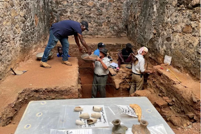
Excavations at Fort Kormantine, within the walls of the more recent Fort Amsterdam. BBC.

The English occupation of the area spans an important shift in European activities in West Africa. When the fort was built in the 1630s the builders were probably primarily interested in trading for gold and other precious materials, but by the time the English occupation ended, the Company of Royal Adventurers of England Trading into Africa had been granted a charter by King Charles II, giving it the exclusive right to trade slaves from Africa with English colonies in the new world, with the term 'Coromantee' being used by both the English and the Dutch to describe slaves from the coast of the area we call Ghana today.

See also...

Follow Sciency Thoughts on Facebook.

Follow Sciency Thoughts on Twitter.


Thursday, 1 September 2022

Understanding the Roman-style forts of Upper Nubia.

The term Upper Nubia is used to identify the area along the banks of the River Nile between the Third Cataract and the confluence of the White and Blue Niles, and the areas of desert and semi-desert that surrounds it. This area is covered by a huge array of defensive structures, mostly dating to the medieval and post-medieval periods; the exact number of these structures is unclear, although it is probably over 300. Some of these structures have been extensively explored by archaeologists, but most have been only briefly surveyed, if at all. As a result of this, the origin of most of these forts is unclear, with estimates based upon surface materials recovered from the sites or just the general shape of the fortifications. 

The largest of these structures, such as Old Dongola and Bakhit, are still the largest structures ever built in this region, but many are much smaller, representing little more than military towers or fortified houses. Among these varied structures, one group stands out for their similarity, a group of small forts with quadrilateral structures resembling Late Roman fortlets. 

In a paper published in the journal Azania: Archaeological Research in Africa on 2 February 2022, Mariusz Drzewiecki of the Polish Centre of Mediterranean Archaeology at the University of Warsaw, and Aneta Cedro of the Institute of Mediterranean and Oriental Cultures of the Polish Academy of Sciences, examine the origins of these forts and try to understand who built them and why.

Map of the Upper Nubia region of Sudan showing the locations of places mentioned in the text. Black squares mark quadrilateral forts, red squares potential forts. Mariusz Drzewiecki in Drzewieki & Cedro (2022).

Drzewieki and Cedro were able to identify nine Roman-style forts in Upper Nubia, spanning about 550 km of the Nile Valley. These are presumed to have been built during Late Antiquity (the second to seventh centuries AD), a time of significant political change in the region. By the second century AD the Kushite Kingdom of Meroe was beginning to break apart into smaller states. In the fourth century, when the Axumite King Ezana sent an army to conquer the region. By the fifth-to-sixth centuries the region was divided into three kingdoms, Makuria, with its capital at Dongala, Nobadia, with its capital at Faras, and Alwa, with its capital at Soba, which, by the late sixth century, were at war with one-another, having converted to different branches of Christianity; the Makurians having adopted Melkitism, and the other two kingdoms having converted to Monophysitism.

The quadrilateral fort at the top of Jebel Umm Marrahi. Mariusz Drzewiecki in Drzewieki & Cedro (2022).

Drzewieki and Cedro consider that three possible explanations for the forts are plausible. 

Firstly, the forts could have been built by the Kingdom of Meroe towards the end of its existence; this is supported by the locations of the forts, which span the final area which the Kingdom was able to hold onto before its eventual collapse. 

Secondly, the forts could have been built by one of the successor kingdoms which emerged in the fifth-to-sixth centuries. A number of forts between the Third and Fourth Cataracts (further downstream) are considered to have been built by the Kingdom of Makuria, though these are less regular in form than the Upper Nubian forts, being moulded to the local topography. All of the Roman-style forts lie within the boundaries of the historic Kingdom of Alwa, with the most southerly fort, Jebel Umm Marrahi, being only 50 km to the north of the city of Soba, which has led to the suggestion that the forts might have been built by the Alwans.

Finally, Drzewieki and Cedro hypothesise that the first of the forts could have been built by Meroe, but then integrated into the defence system of one of the later states and used as a template for the construction of more forts along the same lines.

The nine forts are remarkably similar in construction. The largest, Hosh el-Kab, is only four times the size of the smallest, Wad Mukhtar. The corners of the forts are reinforced by bastions, and most were built using a vertical masonry technique absent from other sites in the area, including the Makurian forts. 

The Middle Nile forts. Mariusz Drzewiecki in Drzewieki & Cedro (2022).

In order to establish who built the forts, Drzewieki and Cedro reason, it would first be necessary to establish precise dates for their construction. Such dates can be obtained from a range archaeological material, but, for the dating of the construction times, only material from the lowest layers within the forts, and the layers immediately beneath their foundations, should be used. Material obtained from the cores of curtain walls or from higher layers within the forts may also prove useful, but their context must be evaluated very carefully.

Vertical masonry in the fort at Mikeisir. Urszula Stępień in Drzewieki & Cedro (2022).

Examination of material from the lowest layers within the forts can also shed light on the lives of the original occupants of the forts, which in turn may help to understand why the forts were built. Items such as ceramics or organic material can reveal a lot about the daily lives of the people who deposited them, as can presence or absence of luxury items, combined with analysis of any food remains. Were the fortified structures intended to house garrisons, act as storehouses, or as fortified dwellings for whole communities? Were they used over a long period of time, or did their construction relate to some specific threat, after which they were abandoned?

Although the forts are very regular in construction, their distribution is very uneven. As mentioned previously, the southernmost fort, Umm Marrahi, lies only 50 km to the north of the Alwan capital Soba. Three kilometres to the north of this lies the fort of Hosh el-Kab, while 500 m to the east of Hosh el-Kab is the fort of Abu Nafisa. This clustering seems to make it unlikely that all three of these forts were in use at the same time, which prompted  a team from the Polish Academy of Sciences to investigate these sites directly.

The location of Abu Nafisa, Hosh el-Kab and Umm Marrahi. Włodzimierz Rączkowski & Mariusz Drzewiecki in Drzewieki & Cedro (2022).

The fort at Umm Marrahi was surveyed by the British archaeologist Osbert Crawford in the 1950s, and some test excavations were carried out there by a team from Khartoum University in the 1970s. The Khartoum team recovered pottery fragments from the fort and from a nearby cemetery, which were of similar manufacture. Based upon this, it was calculated that the fort was in use at some time between the Late Meroitic and Early Christian periods, between about 325 and 650 AD. A radiocarbon date was established for a piece of pottery, which placed it at between 675 and 975 AD, with a confidence level of 94%, but this cannot realistically be extrapolated to a construction time for the fort. Further investigations in the area in the 1980s shed no further light upon the age of the fort. Neither of the other forts has been formally investigated, though some speculation about their origin has appeared in research publications about the area, with suggestions including Meroitic, Makurian, and Early Medieval.

The Polish Academy of Sciences team carried out fieldwork at Hosh el-Kab and Abu Nafisa in 2018, and at Umm Marrahi in 2019. Initial surveys of the sites, combined with interviews with local residents established that many of the structures visible within the forts were of much later origin than their construction, often dating to the Islamic Period. Umm Marrahi contains a mosque, and several associated buildings, which was constructed by a local Sufi brotherhood, while Abu Nafisa contains the tomb of an Muslim Holy Man, Sheikh Abu Nafisa.

The only structures that could be confidently associated with the construction of the forts are their walls. With this in mind the Polish team dug two excavation trenches along the insides of walls at each fort, where possible doing so at the sites of gates or the corners of the forts. Before doing this a careful surface survey was carried out, and previous excavations left by looters, or where paths or irrigation channels had been cut, were inspected.

The fort at Umm Marrahi showing the location of archaeological trenches. Mariusz Drzewiecki in Drzewieki & Cedro (2022).

Before any excavation work was undertaken, a geophysical survey was carried out at each fort, in order to better understand the organisation and state of preservation of the buildings within them. At Abu Nasifa, an area of 7400 m² was surveyed, with the southeastern corner being excluded from the survey in order to avoid disturbing the tomb of the Holy Man. At Hosh el-Kab an area of 13 300 m² was surveyed, excluding only an area where the site had clearly been damaged beyond the usefulness of such surveys by modern irrigation work. At Umm Marrahi an area of only 1600 m² was surveyed, as the bedrock was exposed in many places at this fort.

The fort of Abu Nasifa is the closest of the three sites to the Nile, and has clearly been flooded on several occasions since it was in use. Both the excavations and the geophysical survey carried out here uncovered massive alluvial deposits, with little archaeological evidence from the time of the fort's use remaining. However, the remains of a settlement pre-dating the fort were uncovered, and a number of potentially datable fragments of charcoal collected, potentially providing a maximum age for the fort.

The fort at Abu Nafisa fort showing the location of the archaeological trenches. Mariusz Drzewiecki in Drzewieki & Cedro (2022).

The walls of Abu Nafisa were worn down to their foundation, although it was possible to confirm that these walls were made using a vertical masonry technique. Most of the material collected here came from the surface or upper layers within the trenches, and could be dated to the Funj period (1504-1821 AD). However, a few fragments of older pottery and some beads were recovered from the lowest layers of the fort settlement, these being referable to the post-Merotic/Christian transition period (fifth-to-sixth centuries).

Samples of pottery associated with the beginning of the forts at Abu Nafisa (a)–(c) and Hosh el-Kab (d)–(f). Aneta Cedro in Drzewieki & Cedro (2022).

The largest of the forts surveyed was Hosh el-Kab, which is also distinctive in having thirteen bastions strengthening its corners and curtain walls. It is close to Abu Nafisa, but further from the river, towards the edge of the desert. The site was badly damaged in 2013-4, when a 10 m wide irrigation trench was cut through it. The walls remain to a height of about 70 cm, and are made of irregular stones, bound with mortar, with no signs of vertical masonry ever having been present. 

The fort at Hosh el-Kab with the remains of a church shown by an arrow. Mariusz Drzewiecki in Drzewieki & Cedro (2022).

Geophysical surveys within Hosh el-Kab suggested that most of the buildings that had stood there were made from mud bricks. As with Abu Nafisa, most of the material found within the fort was close to the surface, and dates from the Funj period or later. Some pottery fragments dating to the post-Merotic/Christian transition period were found in the deeper layers of the trenches, and in the area around a former church within the fort.

The fort at Hosh el-Kab in 2018. Mariusz Drzewiecki in Drzewieki & Cedro (2022).

Unlike Abu Nafisa and Hosh el-Kab, the fort at Umm Marrahi is located on top of a hill, and contains numerous stone-built buildings, although investigation of these suggests that all are quite recent in origin. The fort is built directly onto the bedrock, which is still very close to the surface at the centre of the fort. Around the walls, however, a sediment layer was present, up to 1.4 m in depth. Excavations produced material dating to the early Holocene, post-Meroitic, early Christian, Funj and modern eras, with the earliest layers within the walls yielding fragments of cooking and storage vessels, as well as pieces of thin, black-burnished handmade bowls of post-Meroitic origin. No pottery of Merotic origin was found anywhere within the fort, which Drzewieki and Cedro take as evidence that the fort post dates the Kingdom of Meroe.

A total of 22 organic samples were recovered during the excavations, of which 19 yielded radiocarbon dates. The earliest of these dates are from the first half of the fifth century AD, roughly 70 years after the Axumite King Ezana's invasion of the area. Based upon the dates recovered, the most likely origin of all the forts was in the late sixth or early seventh century AD.

The best dated site is Abu Nafisa, the construction of which can be placed between 561 and 574 AD, based upon both material from below the fort and material from the lowest level within the fort. Hosh al-Kab is probably slightly younger, with the lowest layers here dated to between 571 and 604 AD. Umm Marrahi is the least well constrained, but was probably built between 536 and 564 AD. All of these dates are around 200 years after the fall of Meroe, ruling out a Meroitic origin of the forts.

At Hosh el-Kab and Umm Marrahi, the forts appear to have remained in use into the Early Christian era, but then to have been abandoned until the Funj period, with no material dating from the Classic and Late Christian periods present. Abu Nafisa appears to have been abandoned earlier, with no Early Christian material present. 

This suggests that all the forts were only in use for a short period of time, and that Abu Nafisa was abandoned quite soon after its construction. This may relate to the site's vulnerability to flooding; considerable amounts of alluvial sediment were found within the walls of the fort, and the site was inundated during the floods which hit Sudan in 2019. If this was also the case in the sixth century, then it is quite possible that the fort was abandoned in favour of the dryer site at Hosh el-Kab, which would also explain why the two sites were so close together. This larger fort was at the edge of the water in 2019, suggesting that its builders had taken the likely extent of flooding into account when building it.

Google Earth images of Abu Nafisa and Hosh el-Kab during the flood of 2019. Drzewieki & Cedro (2022).

While vertical masonry was used at Abu Nafisa, it is absent at Hosh el-Kab and Umm Marrahi. If Abu Nafissa does predate Hosh el-Kab, this may indicate that Umm Marrahi was built at roughly the same time as the latter; since it was only half the side of Hosh el-Kab it may have been an auxiliary post intended to work in conjunction with the main fort in some way. Whatever the precise relationship between the forts, they clearly point towards the area being a site of strategic importance in the second half of the sixth century AD.

The material recovered from the lower layers within the forts was remarkably uniform across all three sites, with the smallest civil sites in the Middle Nile Valley producing a much more varied range of material, including luxury items and goods brought in from long distances away, all of which were missing from the forts.

The geophysical survey carried out at Hosh el-Kab found traces of mud-brick buildings along the southern and parts of the northern walls of the city, as well as free-standing buildings, including a church, throughout the enclosed area. This was confirmed by a small trench on the northern wall, which uncovered the remnants of a mud-brick structure. Early Christian pottery and other material were found in the area around the church. 

Most of the original structures within Umm Marrahi appear to have been demolished in the nineteenth, twentieth, and twenty first centuries, to make way for newer construction. The buildings of Abu Nafisa appear to have been almost totally eroded away by the action of repeated flooding, although a few places may show the remains of stone floors of buildings.

Pottery is the most common material at all three sites, with a total of 1554 fragments collected in total. The distribution of this pottery was not even; Abu Nafisa, having apparently been used only briefly and then subjected to repeated flooding events, unsurprisingly yielded little pottery. Hosh el-Kab had apparently been the subject of numerous excavations in the post-medieval and modern periods, during which much material had been removed, probably for construction purposes in local villages. Umm Marrahi became a centre of religious activity in more recent times, and as such had been relatively undisturbed by local villagers. Excavations here yielded a range of pottery from different periods. However, none of the sites was completely excavated, and it is likely that the discovered pottery represents only a fraction of the total amount present.

The most distinctive feature of the pottery from the lowest layers at Umm Marrahi is that none of it is wheel-made. All of the pottery is hand made, and though it can be divided into coarse ware with thick walls and crude outer surfaces, and finer ware with smoother surfaces, the difference between the two appears to be purely functional. The finer ware, which is usually covered by a slip, generally black in colour, and burnished or polished, and occasionally decorated, is used exclusively for the production of small bowls or dishes. The cruder pottery, which lacked any slip or burnishing, and often preserved the fingerprints of its makers, was used for making larger bowls.

Black-polished bowls from the earliest phase of the Umm Marrahi fort. Aneta Cedro in Drzewieki & Cedro (2022).

One distinctive group of larger bowls have a shallow, open shape with vertical or steeply sloping walls. The upper parts of these walls are typically thicker, and have a pattern of fingerprints or diagonal cuts along their rims. Fragments of these bowls were found at Umm Marrahi, Abu Nafisa, and Hosh el-Kab, and are also known from Soba. Some of these bowls have soot on their outsides, suggesting that they may have been used for cooking. Fragments of a type of bowl known as a doka, used for the baking of flatbread, were also found, as were pieces of what appear to be storage vessels, including short, wide-mouthed bottles, plain neckless jars, and 'beer jars' which have globular bodies and slender necks.

Examples of coarse ware pottery from the earliest phase of the Umm Marrahi fort. Aneta Cedro in Drzewieki & Cedro (2022).

A lot of the pottery from the lowest layers at Umm Marrahi is very similar to pottery previously recovered from the city of Soba. Notable example of this are the presence the black slip-ware and of a type of thin-walled bowl with carinated (ridged) walls and either a black or red slip. Examples of this sort of bowl, with both black and red slips, have also been recovered from Soba.

Examples of bowls from the Umm Marrahi fort (left) and their parallels from Soba (right). Aneta Cedro and Ewa Czyżewska-Zalewska in Drzewieki & Cedro (2022).

While the lowest layers at Umm Marrahi produced only hand-made pottery, the higher layers did produce wheel-made pottery. All of this could be dated to the Early Christian period, although some of it was clearly inspired by Late Roman patterns. Again, this was similar to material found at Soba, and likely to have been made in the same workshops.

Some of the pottery items found at Umm Marrahi showed signs of repair, including items which would normally have been considered to have been of low value, such as course bowls and storage jars, but which were apparently worth having their lives extended here. Also found were two potsherds which had been polished and cut into circular shapes, which Drzewieki and Cedro take as evidence that they had been used as spindles, thus providing evidence of yarn production.

The excavations carried out at Umm Marrahi by a team from Khartoum University in the 1970s also uncovered ceramics, including two complete vessels, a small bowl and a cooking pot. All of this pottery conformed to the same types recorded by the Polish team. Evidence of the repair of pottery was also present in this sample.

The pottery from Umm Marrahi is remarkably functional, with no examples of 'luxury' items, or anything else that might be used to denote social status. Even the best made bowls, while well executed, are strictly functional in form, and were probably made at local workshops. No amphorae, or other objects which might be associated with long-distance trade were found.

After pottery, the most common finds at the sites were Animal remains, comprising a collection of 562 bones, teeth, and fragments. The majority of the material from the lowest layers can be assigned to Sheep and/or Goats, with a smaller amount of Cattle remains. Also present were pieces of bone from a Rodent and a Hippopotamus. Notably absent were the remains of any non-consumed domestic Animals (such as Dogs, Cats, Donkeys, or Camels), or bones from parts of Animals not typically consumed (such as the phalanges), suggesting that all the Animal remains originally came to the site as meat for consumption, not live Animals.

The preponderance of Sheep/Goat remains, particularly in comparison to the number of Cattle remains, is puzzling, as at other sites in the area, including Soba and Makurian sites, the reverse is true, with Cattle remains being the most abundant. At Soba, the remains of Pigs are also quite common, but these are absent at the forts.

A very small number of other items were uncovered at the forts, including nine beads, eleven stone tools (grinding stones and pestles), and a piece of copper. The complete lack of luxury goods at the sites suggests that the inhabitants were not members of a ruling or wealthy class. The uniform nature of the pottery implies that everyone present was using essentially the same utensils, storage spaces, and goods, while the preserved remains of the original buildings at Hosh el-Kab reveals that living spaces were arranged according to a regular plan.

This does not necessarily imply that all of the residents were of equal status. The fortified nature of the buildings makes it likely that these were military outposts, where rank would probably be clearly recognised, even if the materials used by all ranks were strictly functional. The one problem with this interpretation is that no weapons have been found at the site, which would normally be expected from a garrison fort, although most weapons known from post-Meroitic Nubia are known from burial sites, so this is perhaps not as remarkable as it would be elsewhere in the world.

Part of the problem with interpreting the purpose of the forts is that the political situation in Upper Nubia in the sixth century is poorly understood. The Byzantine scholar and historian John of Ephesus (c.507-c.588 AD) records that in the latter part of the sixth century the kingdoms of the Middle Nile were starting to convert to Christianity, as well as frequently fighting amongst themselves. Little is directly recorded about Alwa or its neighbouring states, but a line of forts between Alwa and Makuria probably implies that the two states were at least close to conflict with one-another. There was also a potential for conflict with Beja nomads inhabiting the Eastern Desert, as well as various nomadic groups crossing the Bayuda Desert.

The King of Alwa is known to have been baptised into the Monophysite branch of Christianity in 580, by the Byzantine missionary Bishop Longinus, who had travelled from Nobadia for the event. Some correspondence between the two monarchs survives, and suggests that the conversion was part of the forging of an alliance against the Makurians, although what this dispute was about, when it started, and how long it lasted, are all unclear.

The Kingdom of Alwa may have reached as far as the Fourth Cataract in the sixth century, with the last of the nine forts being at El-Ar, just upriver of that cataract. This is a huge area, including all of the central part of the former state of Meroe. However, by the end of the sixth century the Kingdom of Makuria is known to have reached to the Fifth Cataract, presumably at the the expense of the Alwans. Some of the forts in this region, such as Mikeisir, were abandoned at this time, while others, such as El-Ar, were modified and used for other purposes, while forts in the Makurian style, such as Karmel and Ras el Gezira, were erected. 

How long this conflict lasted is unclear, though the forts at  Hosh el-Kab and Umm Marrahi clearly remained in use into the Early Christian period. By the middle of the seventh century the Kingdom od Nobadia had fallen to an Islamic Arab army under Abdallāh ibn Sa΄d ibn Abī Sar, which had marched up the Nile and was now threatening Makuria, possibly lessening that state's enthusiasm for war with Alwa.

See also...

Follow Sciency Thoughts on Facebook.

Follow Sciency Thoughts on Twitter.