Showing posts with label Pastoralism. Show all posts

Saturday, 9 August 2025

Officials from the Libyan Tourist Police and Antiquities Protection Agency protecting newly discovered rock art in the Jabal al-Hasawna mountains.

Officials from the Libyan Tourist Police and Antiquities Protection Agency are protecting a series of newly discovered rock engravings in the Jabal al-Hasawna mountains. The rock art was discovered by a Libyan citizen who notified the offices of the agency in Sabha, the nearest city. They are currently under investigation by experts from the Fezzan Antiquities Authority, the Archaeology Department at Sabha University, and the Brak Al-Shati Security Directorate, with a view to determining their historical significance, and how they can best be protected.

Newly discovered rock art in the Jabal al-Hasawna mountains of Libya. Libyan Tourist Police and Antiquities Protection Agency.

The new discoveries include artworks in a number of styles previously described from elsewhere in the Sahara, including art attributed to the Buffalo or Large Wild Fauna Period (so called because the art often features Giant Buffalo, Syncerus antiquus, and other extinct African megafauna). This artwork was created between 12 000 and 8000 BC by hunter gatherer populations living in a still green Sahara, and comprises geometric shapes and images of Animals such as Antelope, Aurochs, Buffalo, Fish, Giraffe, Hippopotamus, Ostrich, and Rhinoceros, painted onto wall panels with clay, manganese, iron oxide, and organic dyes. Examples of Buffalo Period rock art are found across Morocco, Algeria, and Tunisia, and are particularly abundant in the Fezzan Region of southwestern Libya, and around Oued Djerat in the northern part of the Tassili N'Ajjer, Algeria.

Also present is art from the Round Head Period, which was produced by Epipalaeolithic and Mesolithic hunter gatherers from about 7550 to about 5050 BC. Round Head art is painted onto or pecked into rock panel surfaces, and depicts Animals such as Antelope and Barbary Sheep alongside stylised Human figures with rounded heads, often engaged in dancing or other ritual activities. The best known examples of Round Head art come from the Tassili Plateau of southern Algeria, over a thousand kilometres to the southwest of the Jabal al-Hasawna, but examples are also known from the Tadrat Akakas of Libya, and the Djado Plateau of Niger. 

Art from the younger Bovidian, or Pastoral Period, has also been reported. This art style first appears around 6000 BC, and persist to about 700 BC (although most dates to between 5200 and 3800 BC), and contains the first examples of Animal-herding (pastoralism), and depicts Human figures with domestic Animals such as Cattle, Sheep, and Goats, as well as wild Animals such as Antelope, Barbary Sheep, Elephant, and Ostrich. Pastoral Period art contains the oldest known examples of domestic scenes, including women and children, in the Sahara, and is thought to have been made by Neolithic pastoralists migrating seasonally with their herds. The first Pastoral Period art was created while the Sahara was still green, while the latest was made in a desert environment. Over the period the wild Animals depicted in this art reflect this changing climate, as do the locations where it was placed, reflecting changing migration routes as the landscape dried. Examples of Pastoral Period art are common in southwestern Libya and the neighbouring Tassili n'Ajjer area of Algeria.

Younger Horse Period art has also been reported in the Jabal al-Hasawna. This style, dated to between 1200 BC and about 1000 AD, depicts people on Horses and in Chariots, and as well as the first people wearing cloths in Saharan rock art. This style is known from the Tassili n'Ajjer area of Algeria.

Camel Period art appears around 1000 BC and continues to the end of the first millennium BC. This style of art depicts the first Camels in the Sahara, but also domestic Animals such as Cattle and Goats. Men in Camel Period art are often armed with swords, spears, and shields. Examples of Camel Period art are known from Libya, Algeria, and Chad.

See also...

Sunday, 27 October 2024

What abandoned grinding stones can tell us about the medieval town of Handoga in Djibouti.

The abandoned town of Handoga in southern Djibouti covers an area of about 600 m north-to-south and 300 m east-to-west, and is located about 13 km from the border with Ethiopia. Archaeological investigations have suggested that the site was initially used in the twelfth century as an occasional campsite by nomadic herders passing through the region, becoming a permanent settlement in the thirteenth century, from when it evolved into a town, with buildings with stone-built lower portions and wattle-and-daub upper portions coming to replace earlier temporary structures. The town was abruptly abandoned in the sixteenth century, with no sign of any violent upheaval preceding this event. As well as dwellings, the town had a range of open spaces which may have been squares, junctions of streets, or other public spaces, as well as two mosques, both at the northern end of the settlement, and a cemetery, at its southern end.

In a paper published in the journal World Archaeology on 30 September 2024, Jorge de Torres Rodríguez of the Instituto de Ciencias del Patrimonio in Santiago de Compostela, Spain;, and Valeria Franco Salvi of the Instituto de Humanidades at the Universidad Nacional de Córdoba in Argentina present the results of an analysis of grinding stones recovered from C-6000, the first structure at the northern end of Handoga to be the subject of archaeological investigations.

Location of Handoga in the Horn of Africa. De Torres Rodríguez & Salvi (2024).

The C-6000 site comprises two circular stone structures, linked by a series of walls enclosing a central open area, interpreted as having been used for food preparation and other domestic activities. The remains unearthed within this area resemble those found within courtyards excavated towards the southern end of the settlement, with two notable exceptions. Firstly, the site has yielded a quantity of well-preserved charred fruits, seeds, and wood fragments, which are currently under study, and which it is hoped will yield radiocarbon dates which will enable a chronology of the site to be built up. Secondly, excavations at the site have produced 88 fragments of grinding stone stones of different types, the largest collection of such stones not just from Handoga, but from any medieval Islamic site excavated to date, providing a rare opportunity to analyse how these objects were made and used, and any changes in their use over time.

Compound C-600 with main rooms and areas. De Torres Rodríguez & Salvi (2024).

Grinding stones were found across the site, with roughly two thirds coming from collapse layers, while about one third were found on original occupation layers. Grinding stones were found in all areas, with 47% coming from Room A, identified as the principal occupation site, 11% from Room B, identified as a storage area, and 34% from the central area. The stones can be split into two types, passive grinding stones, upon which grains would have been ground, and handstones, which would have been used to grind grains upon the grinding stones. Of the two, passive grinding stones are more common (55, compared to 33 handstones).

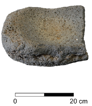
Handstones (upper rows) and one of the passive grinding stones (bottom) found at C-6000. De Torres Rodríguez & Salvi (2024).

Many of the passive grinding stones were highly fragmented, with 17 deemed intact enough for study. All were made from a vesicular-textured basalt, which probably came from an outcrop about 500 m from the settlement. Such a rock would have been ideal for grinding dehydrated or floury products, as it would be relatively easy to clean, and would have maintained a rough surface through use. These grinding stones appear to have been made from nodules or similar, with most made from approximately spherical or approximately cylindrical pieces of rock, with minimal shaping to achieve the desired shape. Despite the fragmentary nature of the grinding stones. about 60% still weighed between 2 kg and 5 kg, with the remaining 40% weighing under 2 kg. Twelve of the grinding stones are thought to have been portable, while the remaining five would have been large objects, presumably immobile during their working lives. The average grinding surface of these stones is 373 cm², with the largest having a surface area of 495 cm².

(1) Outcrop where the material for grinding stones was likely collected. (2) Compound C-6000. De Torres Rodríguez & Salvi (2024).

A much lower number of handstones (32) were recovered, these being largely fragmented, and scattered about with no sign of having been stored. They were apparently left where they lay between uses, and then abandoned once they became to worn for use.  Few showed any signs of maintenance during use, and none of any attempts to prolong their lives. Many of the handstones had been worn-down to the point of uselessness. The often had two wear-facets, showing their users had attempted to gain the maximum utility from them. All the handstones weighed less than 1 kg, with about 40% weighing less than 500 g. The handstones were made from rock which could be collected from within less than a kilometre, with the majority being made from basalt, although granite examples were also present, and one was made from quartzite.

While there appears to have been some variation in the way in which grinding stones were made and used at Handoga, the defining feature that appears to link all of them is an apparent lack of care. Only a minimal amount of work appears to have been put into modifying stones from their natural state to make them into tools, and little investment in their upkeep has been made during their lifetimes. There was no apparent standardized way to make these tools, which suggests that they were not manufactured by specialist craftspeople.

One consistent pattern which can be seen throughout the sample is the division into handstones and passive grinding stones, with grinding stones being larger and made from a single material, vesicular basalt, while handstones are smaller and made from denser and smoother material, with more variation in the selection of that material. A similar pattern has been seen at sites in Cameroon and Mali. There was also a difference in the distribution of these two elements, although the significance of this is unclear.

Large passive grinding stone found during a survey in Handoga. De Torres Rodríguez & Salvi (2024).

De Torres Rodríguez and Salvi suggest that this apparent lack of importance placed upon the manufacture and conservation of grinding stones suggests that these objects were not particularly valued by the people of Handoga. They further suggest that this lack of importance has implications for how we understand the settlement itself. Handoga was initially interpreted as an agricultural settlement, likely deriving water from the nearby Wadi Chekheiti, and trading Sorghum and Millet with the surrounding nomadic groups. However, no archaeobotanical studies have been carried out at Handoga, so there has been no evidence to date to either support or counter this hypothesis. 

In agricultural societies, grinding stones are typically high value items, of considerable economic significance, whereas at Handoga they appear to have been poorly valued, and used within domestic settings. This leads de Torres Rodríguez and Salvi to conclude that while agriculture was probably caried out at Handoga, it was likely a low-status activity, not having the same prestige as traditional nomadic activities such as herding and trade.

This in turn has implications for the history of Handoga. The settlement appears to have been initially used on a temporary camp by nomads in the twelfth century, gradually becoming more permanent, and transitioning to a town with stone buildings sometime in the fourteenth century. De Torres Rodríguez and Salvi reason that the low importance given to the processing of agricultural products suggests that despite becoming a permanent settlement, Handoga never really lost it's nomadic emphasis, something which is also reflected in the design of its buildings.

This in turn helps to explain why Handoga was abandoned so easily in the mid-sixteenth century. During the sixteenth century the Sultanate of Barr Saʿd al-Dīn, which ruled over much of the Red Sea coast of the Horn of Africa, collapsed following a series of disastrous wars with Abyssinia, severely disrupting trade routes, and causing many settlements to be abandoned. For peoples who had become truly sedentary in nature, this would have been a difficult process, either abandoning practices such as agriculture and having to relearn nomadic ways or relocate to other settlements, possibly some distance away. However, if the inhabitants of Handoga had retained an essentially nomadic nature with their main income deriving from pastoralism, the abandonment of the town may have been a less painful process than for more settled communities.

See also...

Tuesday, 16 January 2024

Investigating the walled oasis at Khaybar, Northwest Arabia.

Walled oases appear to have been a key part of the development of early settled societies on the Arabian Peninsula. Unlike other defensive systems, such as isolated towers, fortresses, or even walled cities, walled oases comprised an extensive system of defences enclosing an entire agricultural system, and marking a boundary between this managed farmland and the surrounding desert. Two such walled oases, Tayma and Qurayyah, have been familiar to archaeologists for a long time, and been the subject of numerous studies. However, recent examination of satellite images of the region has exposed a series of previously unknown walls around other oases, including Khaybar, Huwayyit, Dumat al-Jandal, Hait, Al-Wadi, Al-Ayn, and al-Tibq. This process of urbanization and oasis protection appears to have begun during the Bronze Age and persisted into the Iron Age, paying a major role in the appearance of the  caravan kingdoms.

Khaybar has a pre-Islamic period fortress located on a mesa at the centre of the great wadis which dominate the site, but a wall enclosing the entire oasis had not previously been observed or even suspected. The walls are spread over a wide area, and for the most part have been dismantled to the point at which they are hard to recognise. The area is rugged, and made up largely of basalt rock with almost zero sedimentation, so that any and all archaeological remains sit on the surface. This has created a lunar landscape, dotted with archaeological remains from a wide range of periods, including desert kites, mustatils, funerary avenues and dense necropolises, encampments, forts, plot walls, a range of less identifiable structures. To date, about 16 000 such structures have been counted within the 56 km² of land which constitutes the oasis. Determining that dismantled and fragmentary walls scattered over a wide area formed part of a single original structure requires extensive fieldwork and careful examination of the components.

In a paper published in the Journal of Archaeological Science: Reports on 10 January 2024, Guillaume Charloux, Shadi Shabo, Guillaume Chung-To, and Bruno Depreux of the French National Centre for Scientific Research, independent researcher François Guermont, Kévin Guadagnini, also of the French National Centre for Scientific Research, Thomas Therasse and  Mylène Bussy, also independent researchers, Saifa Alshilali of the Royal Commission for AlUla, Diaa Albukaai and Rémy Crassard, again of the French National Centre for Scientific Research, and Munirah AlMushawh, another independent researcher, demonstrate the presence of a defence wall around the entire Khaybar Oasis, as well as providing dating information on its construction and use.

Location map of the Khaybar walled oasis (red and white circle) and other major sites in north-western Arabia. Guillaume Charloux in Charloux et al. (2024).

Six seasons of fieldwork were carried out between October 2020 and March 2023, as part of the Khaybar Longue Durée Archaeological Project. Khaybar is about 670 m above sealevel, and is located in the Hijaz Region of Saudi Arabia, between Medina and AlUla. It was an important agricultural centre in the Early Islamic Period, with the entire oasis measuring about 8 km by 7 km. The oasis is at the confluence of three alluvial valleys, Wadi al-Suwayr/Halhal, Wadi al-Zaidiyyah, and Wadi al-Sulamah, which merge on the western side of the oasis to form the Wadi Khaybar. The wadis are cut into the surrounding Neogene-Quaternary basalt plateau, and contain a series of perched sediment beds. The first (brief) archaeological survey of the oasis was carried out in 2015. This was followed by an aerial survey by the Aerial Archaeology in Kingdom of Saudi Arabia project in 2018, with the Khaybar Longue Durée Archaeological Project beginning in 2020.

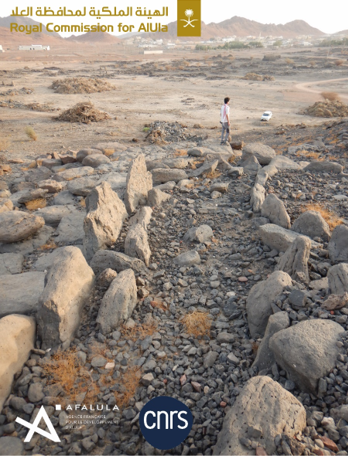
Aerial views of the dry-stone basement of the outer rampart: (A) Segment KH00911 facing south; (B) Segment KH01130 facing north; (C) Segments KH00904-KH00905 and KH00906 facing south; (D) segment KH00922. Guillaume Charloux in Charloux et al. (2024).

Charloux et al. used ArcGIS mapping software to combine aerial photography with high resolution geological maps and e architectural, archaeological and geomorphological surveys of the oasis to build up a map of the wall network. They also dug 19 test pits into sections of the remaining ramparts. 

Map of the main ramparts of Khaybar, with identification of main segment walls and location of bastions and soundings in 2021–2023. Guillaume Charloux in Charloux et al. (2024).

Charloux et al. discovered 5.9 km of previously unknown wall, 5.9 km of which are interpreted as being part of a network which once enclosed the entire oasis. There were 146 large wall segments remaining, ranging in length from a few metres to several hundred metres. The discovered walls were placed into five groups. Group A comprised aligned accretion walls 2.4-4.5 m thick, with both bastions and towers, and without any obvious discontinuity, which formed part of the enclosure surrounding the al-Natah Site. Group B walls comprised two exterior faces with a rubble in-fill, 1.4-2.4 m thick, with bastions, forming part of an inner enclosure wall. Group C walls were similar to Group B walls, but formed part of the outer perimeter enclosing the entire oasis. Group D walls are made from multiple types of masonry, are between 50 cm and 4 m thick, lack bastions, and again form part of an inner enclosure. Group E walls were smaller segments, similar in construction to Group D walls, which did not form part of any obvious larger structure.

View of the ramparts KH00905-KH00906 and a bastion KH00974 during excavation, looking west. Kévin Guadagnini in Charloux et al. (2024).

The remaining outer wall around the Khaybar oasis has a length of 5912.78 m, which is thought to represent 41% of an original wall which would have measured 14.5 km, enclosing an area of 11.8 km². The wall is interrupted by a variety of newer roads, buildings, gardens, etc., making it difficult to reconstruct the entire shape of the perimeter boundary, particularly on the southern side. 

Rampart KH00909, looking north. Charloux et al. (2024).

Seventy four bastions are still present on this outer wall, wall facing out towards the desert rather than in towards the oasis, which Charloux et al. consider to be strong evidence for the entire enclosure to have been built in a single phase of construction, albeit one which would have taken some time and been subject to subsequent additions and alterations.

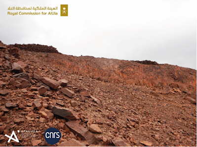
Rampart KH00911 situated on the crest (right on the picture), looking east. Guillaume Charloux in Charloux et al. (2024).

The walls of the outer perimeter are also very similar throughout their extent, most being rubble-filled, double-faced dry-stone walls, between 1.8 m and 2.4 m thick, which again supports a single interval of wall building. The walls appear to have been built in separate segments, with the thinnest section on the slopes and summits of Jabal Mushaqqar, where it is only 1.1 m thick and built of simple drystone masonry, which was apparently acceptable to the builders for this s high position along a ridge on the top of a rhyolite mountain. Earlier stone structures in the region appear to have been raided extensively for building stone.

View of the currently preserved masonry of the outer enclosure wall (rampart KH01130) facing north. Guillaume Charloux in Charloux et al. (2024).

The majority of the wall is made up of curvilinear sections which for the most part follow the contours of the plateau, with connections between these long sections crossing valleys at their narrowest points. Ramparts are between 120 m and 250 m from the cliff edge, apparently built at this distance to avoid the topological irregularities associated with the cliff. Building the wall in this way would have given good visibility over both the oasis and the surrounding desert, while enclosing the minimum amount without encroaching on the agricultural land.

Rampart KH00911 on top of the cliff, looking north. Guillaume Charloux in Charloux et al. (2024).

The height of the original walls is impossible to determine; only the stone bases of the walls remain, but there are traces of mud bricks in places, which suggests a brick superstructure existed on top of the stone wall. The highest remaining section of wall is 3 m tall, at Makidah on the southern section. Charloux et al. suggest another 2 m of brick wall may have existed on top of this, possibly with a walkway. The walls at the Tayma Oasis, have been estimated at 6 m high, with an inner enclosure which might have been 14 m high, while the walls at Dumat al-Jandal have been estimated at 6.5 m, and a section of walkway has been identified.

Rampart KH00919, with dismantled infilling, looking northeast. Guillaume Charloux in Charloux et al. (2024).

There are no contemporaneous structures attached to the outer wall, which is made of basalt and has been heavily eroded by the desert winds and runoff from the annual rains, as well as depletion due to raiding by later builders of other structures, all of which tend to make dating of any structure difficult. However, the wall is built over several older pendant tombs, some of which were also raided for stone by the wall builders. These tombs have been dated to the middle of the third millennium BC, which makes it impossible for the wall to have been built before about 2600-2200 BC. 

Rampart KH00918, looking northeast. Guillaume Charloux in Charloux et al. (2024).

Charloux et al. were able to obtain radiocarbon dates from eight charcoal samples obtained from five test pits sunk into the remaining wall segments. The oldest of these come from beneath the wall, providing a maximum age for the overlying wall segment. Other samples come from layers abutting the rampart or in the immediate vicinity of its foundation, suggesting they provide a time for the construction or first use of the wall, while other pieces come from the wall infill, which again makes it most likely they date from the time of wall construction. Finally, sone charcoal pieces come from beneath what appear to be gates in the wall, and could therefore have been deposited while the wall was in use.

Rampart KH00918, looking southwest. Guillaume Charloux in Charloux et al. (2024).

Based upon these radiocarbon dates, Charloux et al. suggest that the outer perimeter wall at Khaybar Oasis was built after 2279 BC, and probably after 2139 BC, but probably before 2201 BC and definitely before 1980 BC. The wall appears to have still been in use as late as 1741 BC and 1542 BC.

Location of dating samples on rampart KH00905 (plan on orthophotography and sections). Section 1: KH00906.002 and KH00906.004 are filling layers above ash area KH00906.005 on top of construction floor KH00906.006; Section 2: KH00905.002 is a collapse layer above a thin ash dump above fills KH00905.003 and KH00905.005 above possible construction floor KH00905.004. Guillaume Charloux, François Guermont & Kévin Guadagnini in Charloux et al. (2024).

This suggests that the Khaybar Oasis, one of the largest in Arabia, was enclosed by a perimeter wall in the Bronze Age, around 2000 BC. The appearance of such walled oases is thought to have been a key step in the evolution of urbanization in the region. The walls presumably offered protection against raids from the desert, a danger to settlements on the Arabian Peninsula in the pre-Islamic and Early Islamic Periods, but one for which evidence has been absent in the Bronze Age until now, despite the presence of Bronze Age 'Warrior Burials' in northern Arabia. Such walls may have also plaid a role in controlling the environment within the oasis, helping to prevent soils from blowing away and helping to prevent flash floods from reaching crops. The walls would also have made a symbolic statement about the ownership of the oasis, clearly delimiting a boundary between the territory inside the wall and the open desert. This would have been a powerful symbol to any desert groups seeing it, and presented a clear social identity to those within.

Dismantled bastion at the front of rampart KH00918, looking southwest. Guillaume Charloux in Charloux et al. (2024).

The size of the surrounding wall suggests that a reasonably large workforce was involved, and that local political leadership was sufficiently organized to co-ordinate such a project. It has previously been assumed that large building works like this in Bronze Age societies would have required very large numbers of workers, but recent evaluations of workloads has suggested that much smaller numbers of people might have been able to undertake large projects. Constructing the outer wall to a height of 5 m would have required the movement of 164 000 m³ of stone, and/or bricks, which Charloux et al. would have required 170 000 working days. Whilst this seems a lot, a community of 500 people, in which half of the population could spend six months of each year on the project, would have been able to construct the outer wall in four years. Had half the population been able to work on the project full time, then only two years would be needed to construct the wall. Furthermore, while some degree of planning would no doubt have been needed to complete the project, many of the choices which would have had to be made are not complicated, so a large bureaucracy was probably not needed, again suggesting the task was within the grasp of a relatively small community.

Test pit in gate KH09039 on rampart KH01130 (plan on orthophotography and section), with location of dated samples. Outside the gate, KH09039.004 is a small layer of brown gravel laying directly on the substratum below the stone collapse. Inside the gate, the collapse was underlain by KH09039.009, an occupation level consisting of grey, coarse sandy sediment with some charcoal and animal bones. Below, a layer of brown gravel (KH09039.010) was laying on the bedrock. Guillaume Charloux, François Guermont & Kévin Guadagnini in Charloux et al. (2024).

Pastoralists from northwest Arabia, where local communities were already building walled and fortified settlements on the fringes of the desert in what is now southern Lebanon and Syria, are thought to have settled at Khaybar Oasis during the Early Bronze Age, building avenues of monumental funerary structures, as at other oasis in the region, and on the trails between them. The skill set needed to build these large funerary structures is not greatly different from the one that would have been needed to construct fortified ramparts around an oasis, so the construction of avenues of funerary monuments hay have been the first stage in a transition from a pastoralist, nomadic existence to a more settled farming one where strategic territories with good water supplies were enclosed and defended. The nature of such projects would have favoured the development of a more hierarchical society, leading in time to the development of more formal urban centres. This settling and enclosing of the oases may have been linked to a drying climate, which would have made wandering pastoralism more precarious and reliable sources of water more precious, although the history of the climate in the region is not well enough understood to make firm assertions about this.

Rampart KH01130, looking north. Guillaume Charloux in Charloux et al. (2024).

Ramparts appear to have been erected around the entire oasis between about 2250 BC and 1950 BC, making these fortifications younger than the ones at Qurayyah, which were constructed in the first half of the third millennium BC, or and those at Tayma, built in the second half of the third millenium BC, but older than the Iron Age fortifications at Dûmat al-Jandal. This is interesting, as it shows a repeated process of oasis enclosure at different sites, over a lengthy period of time. Understanding why this happened would be a significant step in understanding the development of Bronze Age and Iron Age societies in Arabia, and the trajectory of urbanization followed there.

Reconstruction view of the northern part of walled oasis of Khaybar around 2000 BCE. Pending the results of definitive archaeobotanical analyses, the Plant cover at this stage is based on the identified species (Acacia, Tamarisk, Amaranth, cereals). Mylène Bussy & Guillaume Charloux in Charloux et al. (2024).

Charloux et al.'s field surveys and archaeological excavations have demonstrated that the Khaybar Oasis in Northwest Arabia was once enclosed by an immense surrounding wall, similar to that seen around other oases in the region. This dates from the late third millennium BC, and was probably constructed by a local pastoralist community settling and claiming the oasis as their territory. The walls appear to have remained in use for several centuries, before being partially dismantled and replaced with other structures. This marks out the oasis as an important stage in the development of urbanized communities in the region, and key part of the heritage of Arabia.

See also...

Monday, 31 July 2023

Cattle in the rock art of Wadi Bajdha, Saudi Arabia.

Saudi Arabia covers an area of about 2 million km² with rock art known from every area of the country. A comprehensive survey of the rock art of Saudi Arabia begun in 1981 took over 15 years to complete, and recorded over 2000 sites with pre-Arabic and early Arabic inscriptions, as well as thousands of petroglyphs (images made by inscribing into a rock surface).

In a paper published in the Journal of Historical Archaeology and Anthropological Sciences on 3 July 2023, Majeed Khan and Faisal Al-Jabrin of the Antiquities Sector of the Saudi Ministry of Culture, describe a newly discovered rock art site at Wadi Bajdha in the Tabuk Region of Saudi Arabia, and discuss the implications of the images discovered there.

The art is located in a deep valley surrounded by mountains to the northwest of the city of Tabuk, where water collected during the rainy season. The site has historically been visited seasonally by Bedouin herders, and may have, at times, hosted permanent settlements.

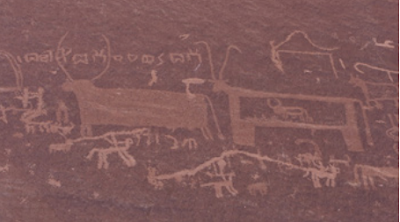
The rock art is located on a vertical rock face on the side of a hill, which appears to contain images from different periods. The oldest figures on this panel appear to be a group of Cattle with short horns and flat humps. These Cows appear to be different from both the long-horned Oxen depicted at the Neolithic sites of Jubbah and Shuwaymis, and the high-humped Indian Zebu-like Cattle depicted in the Najran area of southern Saudi Arabia. Khan and Al-Jabrin suggest that this art represents the second phase of Cattle domestication in Saudi Arabia, following the Neolithic long-horned Oxen phase.

The rock art gallery at Wadi Bajdha in the Tabuk Region, in north of Saudi Arabia. Khan & Al-Jabrin (2023).

The rock art of Saudi Arabia is highly diverse, and appears to have been produced in a range of contexts with different purposes and meanings. Neolithic images appear to show Oxen as both Animals hunted as prey, and as sacred or possibly Divine Animals. Chalcolithic images have been interpreted to show Oxen as mythical creatures, deities, and sacrificial Animals. With this in mind, Khan and Al-Jabrin are careful to compare the Wadi Bajdha rock art to rock art from other locations, before drawing any conclusions about its meaning.

An open air temple, where Cows are depicted with idoliform images possibly deities or gods, located in Wadi Damm northwest of Tabuk. Believed to be evidence of Cow worship in Arabia. Khan & Al-Jabrin (2023).

Archaeological evidence and rock art depictions both suggest that Wild Cattle, Bos primigenius, were present in Arabia as both wild and domestic Animals during the Neolithic. At sites such as Shuwaymis, Jubbah, Hanakiya, large numbers of Oxen are depicted, with flat backs and exaggerated horns. These resemble European Wild Cattle, Bos primigenius, an Animal not known after the Neolithic climate shift, which occurred about 7900 years ago in northern Arabia, and led to a shift from a cool, humid climate to a hot, arid one.

Long-horned flat-back Oxen from the  Neolithic Shuwaymis site in the north of Saudi Arabia. Evidence of the presence of Wild Oxen in Arabia. Khan & Al-Jabrin (2023).

Petroglyphs of Cattle in Saudi Arabia represent at least three separate climatic phases, which each phase associated with images of different sizes, styles, and execution techniques, which has enabled the development of a chronology for such art, which links Animal type to climate shifts.

Earliest known image of Long-horned Cow, Bos primigenius, from Saudi Arabia dated to about 9000 BC. This image located at the Neolithic Jubbah, site in the north of the country. Superimposed on the Cow is a Camel figure of much later period. There is a difference of several thousand years between the two Animals; representing two climatic phases; cool and humid (Cow) and hot and dry conditions (Camel). Khan & Al-Jabrin (2023).

The style of the rock petroglyphs at Wadi Bajdha suggests that the art dates from the Chalcolithic Period, about 3500 BC. At this time people in the area had domesticated Cows and Goats, and engaged in small-scale hunting along with the hunting of Ibex. Camels did not appear in Arabia until the Bronze Age (along with Date Palms), and are absent from the Wadi Bajdha art. 

A pregnant Cow. A small baby can be seen inside the mother Cow, a firm indication of a domesticated Cow. Domesticated small horned and flat back Cattle are found on several sites in northern and southern Arabia representing the middle phase of Chalcolithic domesticated Cows, around 3500 BC. Khan & Al-Jabrin (2023).

The left corner of the Wadi Bajdha panel depicts a number of large, Chalcolithic-style Cows, as well as several Ibex, and some Horse riders with lances. These appear to have been made by artists from different periods, who took care not to overlap the art, as well as some tribal symbols. Battles between riders armed with lances was common among Bedouin tribes into the recent past.

The third phase in the art gallery represented by Camel and pre-Arabic Thamudic inscriptions in addition to Horse riders with long lances in fighting attitude drawn by the people representing the last phase of rock art in this gallery. Khan & Al-Jabrin (2023).

The Wadi Bajdha art shows apparently domesticated Cattle, including a pregnant female with a baby inside, but no images of Camels, suggesting that this art is Chalcolithic in origin. The site is likely to have has good living conditions during this interval, supporting a permanent or semi-permanent population, who presumably left as the climate continued to get hotter and drier. Many other rock art sites in Saudi Arabia show similar combinations of Human and Animal figures, and appear to have been abandoned after short periods of occupation. This suggests that the population of Saudi Arabia has been largely nomadic for much of its history, inhabited by groups who moved regularly depending on the availability of water. 

See also...

Follow Sciency Thoughts on Facebook.

Follow Sciency Thoughts on Twitter.