Showing posts with label Slavery. Show all posts

Saturday, 7 June 2025

The landscape of the Zanj Rebellion?

The Shaṭṭ al-ᶜArab floodplain in the Basra Governorate of southern Iraq is covered by a vast network of linear earthwork ridges, covering an area of more than 800km², far more extensive than the area under conservation today. These are thought to have been built between 630 AD, when the city of Old Basra was founded, and the late ninth century AD, when the city was engulphed in a period of political turmoil. 

These earthworks are thought to have been built by a workforce of slaves known as 'the Zanj'. The term 'Zanj', in Medieval Arabic refers to the Swahili Coast of East Africa, and it has been suggested that the slaves of Medieval Basra may have been sourced from that area, however, 'Zanj' is also sometimes used for slaves from other origins (possibly making the East Coast of Africa the 'Slave Coast'). 

Thus the Zanj of Basra have been thought by various authors to have been either East African slaves, a mixture of East African and locally enslaved peoples, or possibly slaves from other parts of Africa (it is unclear if slave routes from East Africa had been established by the period when the earthworks were built, but slave routes from West and West Central Africa via North Africa are known to have been well established.

In 869 AD the slaves of Old Basra rose up in what is now known as the Zanj Rebellion. This destbalized the region leading to over a decade of civil strife before the Abbasid rulers of Iraq managed to regain control of the area. Two earlier, and smaller Zanj rebellions were also recorded in 689-90 AN and 694-695 AD, although these were apparently local affairs put down quickly, whereas the rebellion of 869 had a wider and more long-lasting political impact.

At the time of the rebellion of 869, the Zanj are recorded to have been spread out in a series of work camps in the agricultural zone to the east of Old Basra, on both sides of the Shaṭṭ al-ᶜArab River. This coincides with the area covered by the system of Earthworks, so presumably key events of the rebellion took place within this system. The Zanj are recorded to have established their headquarters at a location called al-Muḫtāra within the agricultural area where they once toiled, although the precise location of this is unknown today.

The Zanj Rebellion has been attributed to the harsh conditions under which the Zanj were forced to live, although details of this are lacking in records. If the earthworks of Shaṭṭ al-ᶜArab are the result of Zanj labour, as is generally assumed, then this could have been the exploitative labour which triggered the rebellion. However, the Earthworks have never been accurately dated, making the relationship between the earthworks and the rebellion essentially a matter of guesswork.

In a paper published in the journal Antiquity on 2 June 2025, Peter Brown of the Department of History, Art History and Classics at Radboud University, and the Department of Archaeology at Durham UniversityJaafar Jotheri, also of the Department of Archaeology at Durham University, and of the Department of Archaeology at the University of Al-QadisiyahLouise Rayne of the School of History, Classics & Archaeology at Newcastle UniversityNawrast Abdalwahab of the Department of Geology at the University of Basrah, and Eric Andrieux, again of the Department of Archaeology at Durham University, present the results of a study of the Shaṭṭ al-ᶜArab earthworks, including the first chronology of their creation and use.

Location and distribution of the ridge/earthwork system, showing the extent covered by the project study area in southern Iraq. Brown et al. (2025).

The ridges which make up the Shaṭṭ al-ᶜArab earthworks are typically between 400 and 1200 m in length, 20-50 m wide, and rise up to 2 m above the surrounding ground level. The Earthenworks comprise a series of blocks of parallel ridges separated by 100-250 m of flat land. The ridges abut large canal features at right angles, with smaller irrigation canals running along the centre of the flat areas between the ridges. Ultimately, these canal systems connect to the Shaṭṭ al-ᶜArab river, with some still carrying water up to 5 km from the banks of the river.

Drone photograph looking west showing several linear ridge features within the study area. Brown et al. (2025).

Both modern satellite imgery and satellite photography from the 1960s suggest that there are about 7000 ridges across the Shaṭṭ al-ᶜArab floodplain, ranging from about 15 km south of the town of Al Qurnah in the north to the town of Abadan in Iran in the south. The total length of the ridges is about 3000 km, implying a significant amount of labour by a large number of workers was needed to create the systm.

CORONA satellite photograph of a typical area of ridge/earthwork features within the study area. Photograph number DS1035-1040DF019 captured 23 September 1966. US Geological Survey in Brown et al. (2025).

There are several potential explanations as to how the ridge-and-canal system was created and used. The ridges could either have been formed as part of a process of clearing the land for agricultural use, or formed over time as canals were repeatedly cleared of sediment. In 1962 the American archaeologist H.S. Nelson published a study of the ridge system, in which he established that the soil of the ridges was twice as saline as the surrounding soil, which led him to hypothesise that the irrigation practices used led to the soil becoming saline over time, and the ridges were built up as this saline soil was repeatedly cleared. However, it is unclear how many soil samples Nelson took, nor from where in the system, making it difficult to assess how applicable his findings are to the whole system.

Drone photograph looking north-west showing ridge features with parallel relict canal channels in the interspersing flat areas. Brown et al. (2025).

The ridge system clearly has a relationship with the Shaṭṭ al-ᶜArab river, and it appears that the canal-system once allowed the cultivation of large areas of the Shaṭṭ al-ᶜArab floodplain through tidal irrigation. This area is above the saline estuary of the river, but twice a day tides in the Persian Gulf push freshwater to flow upstream within the river, and this can be utilized to feed an irrigation system. Similar systems are utilised elsewhere in the world, including West Africa, where it has been practiced for at least a thousand years, and Spain, where the practice can be traced back to at least the sixteenth century.

CORONA satellite photograph showing active canals and agriculture among the ridges in the 1960s. Photograph number DS1045-1040DA041 captured 27 January 1968. US Geological Survey in Brown et al. (2025).

A number of medieval authors mentioned a tidal irrigation system in use arround Basra. The tenth century Arab geographer al-Muqaddasī described a system of canals with mills at their mouths, which were driven by the ebbing tide as the water withdrew following each tidal flood. Two centuries later the writer al-Idrīsī described a canal system around Basra, driven by rising tides and used to irrigate crops. The fourteenth century writer Abū al-Fidāʾ described ships using the tide on the Shaṭṭ al-ᶜArab to reach Basra and its canal systems. However, in the early seventeenth century, the Portuguese traveller Pedro Teixeira described the area as infertile and covered with salt, although with evidence of former agricultural activity still visible.

The most northerly of the ridges are close to the town of Al Qurnah, which is also approximately the northernmost extent of tidal flow on the Shaṭṭ al-ᶜArab, which supports the idea that these are connected. The uniformity of the ridge-and-canal system throughout the Shaṭṭ al-ᶜArab floodplain also indicates that this system was intended for a single form of agriculrure. 

However, what sort of crops were grown there is less clear today. H.S. Nelson thought that the spaces between the ridges would have been suitable for the cultivation of Winter Barley, whereas medieval authors associated the Basra area with Date production, and dates are still farmed along the Shaṭṭ al-ᶜArab today. Ceramic vessels from southern Iraq, which are believed to have been used to transport Dates, are common finds at archaeological sites as far away as China. Dates also form an important part of al-Ṭabarī.’s account of the Zanj rebellion, with the rebels described as hiding in Palm-groves on the salt flats to ambush Abbasid troops, and Abbasid cavalry being impeded by the densely packed Date trees. The famous fourteenth century travelled Ibn Baṭṭūṭa noted that '“no place on earth exceeds [Basra] in quantity of Palm-groves', and Pedro Teixeira also considered the area to be notable for date production. 

Dates are a relatively salt-tolerant crop, although the levels of salt recorded by H.S. Nelson would be a serious problem, reducing crop-yields by about 50% in the least affected areas between the ridges. Furthermore, Dates are seldom, in traditional agriculture, grown on their own. Rather they tend to be intercropped with other produce, such as fruits, vegetables, Rice or Barley, which benefit from the shade provided by the Date trees. If crops require more light, the Dates can be planted further apart. 

Medieval literature does not provide any direct descriptions of the system used on the Shaṭṭ al-ᶜArab floodplain. However, a number of sources may provide glimpses of how this worked. Al-Ṭabarī.’s description of the Zanj Rebellion makes several references to hills on the floodplains, including one hilltop which overlooked a Date Palm grove. Since there are no natural hills on the Shaṭṭ al-ᶜArab floodplain, it seems likely that this refers to the artificial ridge structures. An anonymous eleventh-century chronicle, the Kitab al-‘Uyun, refers to the Zanj creating hills to make the area cultivatable, but provides no further details.

Brown et al. first built up a map of the entire area, using a combination of modern sateellite imagary and CORONA satellite images from the 1960s. Based upon this they then chose sites for sample collection across the area. The samples collected were then subjected to radiocarbon and optically stimulated luminescence dating, with the later being particularly useful, since it can date how long mineral grains have been exposed on the surface (the technique was developed for use on samples returned to Earth by the Apollo Lunar Program) and does not therefor require the finding of organic objects, which can be difficult in environments such as the Shaṭṭ al-ᶜArab floodplain. 

Many of the ridge structures show signs of recent damage, due to the construction of infrastructure for oil fields, and the First Gulf War of 1990-91. Brown et al. wished to collect samples from areas undisturbed since the abandonment of the system, and therefore avoided areas with clear signs of recent disturbance. They also wished to take samples from different parts of the system, to determine whether the whole network had been in use at once, or whether different parts date from different periods. Fieldwork was carried out in January 2022, with exploratory trenches dug into four ridge tops and one relict canal-bed.

Locations of sampling sites within the system of ridges. Brown et al. (2025).

No real stratigraphication was found on any of the ridges; each had an upper layer of topsoil with gypcrete crystals, between 50 and 200 mm thick, beneath which the ridges were composed of unstratified silty clay. The trench excavated in a canal bed was dug to 95 cm, and encountered five distinct layers of clay and/or silty clay. Two of the ridge-top trenches produced fragments of shell which were retained for carbon dating. Samples were collected from all sites for optically stimulated luminescence dating.

Drone photograph looking down on the excavation into the ridge crest at sampling site 2. Brown et al. (2025).

The first of the shells subjected to radiocarbon dating yielded a date of between 58 and 215 with a probability of 92.6%, while the second produced a date between 326 and 433 AD with a probability of 81.7%. 

The optically stimulated luminescence dating results all yielded dates between the late ninth century and the mid thirteenth century AD, though a clear chronology could not be established as uncertainty intervals between samples overlapped and samples taken from deeper within the ridges were often younger than those found on the surface. The wide uncertainty values produced by the samples mean that each ridge could have been formed in a single episode, or built up over about a century. The oldest samples post-date the Zanj Rebellion.

Samples being taken for optically stimulated luminescence dating. Left to right: site 1, site 3, site 5 and site 4. Brown et al. (2025).

Both shell samples yielded radiocarbon ages significantly greater than the optically stimulated luminescence dates from the surrounding sediment. This is not particularly surprising, as the process of excavating sediments and incorporating them into the ridges is likely to also excavate older shells and incorporate those. 

Brown et al.'s excavations were limited, and all the samples come from within the homogeneous ridge-cores rather than reaching the undrlying sediments. This only establishes that the ridges were in existance in the century after the Zanj Rebellion (working on the basis that the ridges were a gradual accumulation, as sediments were continuously removed from the canals over time, a process without which the canals would have become blocked).

The sediments collected from the canal yielded slightly older dates than those from the ridges, with the oldest dates (between the eighth and the mid-eleventh centuries). Above this layer is a dark green layer about 10 cm thick, with the layer above this yielding a date of 1423-1503 AD. The dates above and below this green layer are before and after the dates obtained from the surrounding ridges, while th green layer itself appears to represent a period of low sediment deposition, consistent with the removal of sediment by Human activity. 

Brown et al.'s results demonstrate that the ridges of the Shaṭṭ al-ᶜArab floodplain are of medieval origin, and that material was being deposited onto them between the ninth and thirteenth centuries. This is contrary to expectations for the region, where it is generally assumed peak agricultural activity occurred prior to the Zanj Rebellion, and that this was followed by a period of reduced economic activity. It is, however, in keeping with the accounts of visitors to the area at the time, who record that Basra was smaller and less populous than before, but still prosperous and well kept. These visitors also continued to record an active canal system in the area, suggesting the assumption that agricultural practices had been curtailed is probably erroneous.

Optically stimulated luminescence dating results compared against major and local historical events. Samples 3.1, 3.2, 3.3, and 3.4 come from the canal bed, with sample 3.1 from above the green clay layer, and samples 3.2, 3.3, and 3.4 coming from below. All other samples are from ridges. Brown et al. (2025).

Brown et al.'s work does not identify who built the earthworks of the Basra hinterland, but it does demonstrate that large-scale, labour intensive agriculture was still happening in the area after the Zanj Rebellion. It has been claimed that the rebellion led to a reduction in the number of slaves being used by the Abbasids, although this is not universally accepted, and the writer Nāsir Khusraw records large numbers of African slaves being used in agriculture at al-Ahsa in eastern Arabia (also under Abbasid rule) in AD 1050. If the Zanj Rebellion did not lead to the abandonment of large-scale agriculture on the Shaṭṭ al-ᶜArab floodplain, then some other event must have been responsible. Brown et al. suggest that this may have been the Mongol invasions of the mid-thirteenth century, which are known to have damaged the economic importance of Baghdad and the Gulf region, potentially also reducing the need for large scale economic production in southern Iraq.

It is also possible that climate change played a role in the abandonment of this system. The climate of the Gulf region, and in particular the Tigris catchment have been aridifying steadily since the mid tenth century. Since the Tigris flows into the Shaṭṭ al-ᶜArab, it is quite possible that a point was reached where water levels in the river were too low to sustain a large scale irrigation system on that river's floodplain.

Another possibility is that the agricultural system of the Shaṭṭ al-ᶜArab floodplain collapsed as a result of the plague outbreaks of the fourteenth century. These are estimated to have killed about 42% of the population of the Middle East, with Baghdad's rural hinterland known to have been particularly badly hit. If this was also the case in the Basra hinterland, then it would have been almost impossible to keep a large-scale, labour intensive agricultural system going, particularly one dependent on the constant maintenance of irrigation systems.

It cannot be determined, at this time, if any of these factors, or some combination of them, was responsible for the abandonment of the Shaṭṭ al-ᶜArab earthwork system. There was clearly a major shift in habitation in the area between the mid-fourteenth and early sixteenth centuries, with the decline and then abandonment of the city of Old Basra, in favour of the new city at the current location, on the banks of the Shaṭṭ al-ᶜArab, as well as a great reduction in the area under cultivation on the banks of the river.

Brown et al.'s work runs contrary to the traditional narative of the history of Basra, which is seen as having had its heyday in the Ummayad (661-750 AD) and early Abbasid (750-about 900 AD) periods, followed by a long period of decline. Instead it demonstrates that large-scale agriculture was still occurring in the ninth to thirteenth centuries, suggesting that the Zanj Rebellion did not have the long term economic significance it is sometimes ascribed.

However, Brown et al. only looked at four of the 7000 plus ridge systems which cover the Shaṭṭ al-ᶜArab floodplain, making it difficult to assert the extent to which the dates obtained reflect the chronology of the wider area. All of the ridges studied are on the west bank of the Shaṭṭ al-ᶜArab, and fairly close to the location of Old Basra. Potentially, this might have been the last part of the system as it was abandoned across the floodplain, being closest to the city dependent on it.

See also...

Friday, 3 January 2025

Using strontium isotope ratios to try to determine the origin of victims of the transAtlantic slave trade.

Between the fifteenth to nineteenth centuries, at least 12.5 million people were abducted from sub-Saharan Africa and taken as slaves to the Americas, and to a lesser extent Europe, the largest forced migration in Human history. This has had a profound impact on the demographics, economics, and politics of both Africa and the Americas, and while is some ways the process was well-documented (we have, for example, documented records of the voyages of at least 30 079 vessels which were involved in the slave trade, including records of ports they visited and the number of captives they transported), we know very little about the identities of the individuals involved and their actual points of origin.

Recent studies have used genetic information from archaeological remains from the Caribbean, Brazil, North America, St Helena, and South Africa, have had some success in determining the populations from which individuals descended, this cannot tell us where they a person was born or brought up.

Strontium isotopes (specifically the ratio between the isotopes strontium⁸⁷ and strontium⁸⁶) in water are largely determined by bedrock, as well as rainfall and geomorphology, and is taken up and incorporated into biomineralized tissues, such as tooth and bone. Importantly, these ratios remain stable over archaeological timescales, enabling archaeologists to use them to determine the origin of Human and Animal remains, as long as a geological reference map, with the isotope ratios present in appropriate locations, is available. 

In sub-Saharan Africa, strontium isotope ratios have been used to trace the migration routes of large Mammals, and to determine the origin of ivory seized from smugglers, as well as to analyse landscape use by early Hominins, but has been under-used in other spheres, such as historical archaeology, largely because data on strontium isotope ratios are not available for large areas of the continent, and in particular much of West and West-Central Africa, the areas from which the overwhelming majority of slaves were taken to the New World. This is in part due to the high cost associated with carrying out strontium isotope testing over large areas, with the added complication that some parts of the continent are plagued by ongoing conflicts and political instability, making the necessary fieldwork difficult and dangerous.

In a paper published in the journal Nature Communications on 30 December 2024, a team of scientists led by Xueye Wang of the Center for Archaeological Science at Sichuan University and the Anthropology Department at the University of California Santa Cruz, present strontium isotope ratios from 778 new environmental studies from 24 African countries, mostly in West and West-Central Africa, which they combine with 1488 previously published strontium isotope ratios from other studies, to build a more detailed map of strontium isotope ratios across sub-Saharan Africa. These are then compared to ratios obtained from Human remains at two cemeteries in the Americas associated with African slaves, the Anson Street African Burial Ground in Charleston, South Carolina, and the Pretos Novos Cemetery in Rio de Janeiro, Brazil.

Strontium⁸⁷/strontium⁸⁶ ratios in Africa range from 0.70381 to 0.87810, a far higher range than is known from any other continent studied. Some areas have a high proportion of radiogenic strontium⁸⁷, notably those areas with an underlying Archaean bedrock, such as Angola, Zimbabwe, Zambia, western Tanzania, northern South Africa, Côte d'Ivoire, Liberia, Sierra Leone, and southwestern Mali. Other areas have a very low level of strontium⁸⁷, particularly areas of East Africa covered by Mesozoic-Cainozoic volcanic rocks, and areas of South Africa covered by flood basalts, as these tend to generate soils with a high cation exchange capacity and clay content. Strontium ratios are also affected by precipitation levels and elevation, both of which impact the weathering rate of silicate rocks.

Geological map and sampling locations. (a) Simplified geological map. (b) Map showing the environmental sampling locations from this study and previously published work. The sampling locations focused on filling gaps in West Africa, West-Central Africa, and parts of South Africa, covering all major geological units across the African continent south of the Sahara. Wang et al. (2024).

Strontium isotope ratios were analysed for five individuals from the Anson Street African Burial Ground for which genetic analysis had been used to determine a population-of-origin, and five individuals from the Pretos Novos Cemetery, for which this data was not available, but oxygen isotope ratios, which can be used to determine diet, were.

Two of the Anson Street African Burial Ground individuals had previously been determined to be of West-Central African origin, both of which produced strontium isotope ratios consistent with an origin in eastern-central Angola. The remaining three individuals were all determined to be from West Africa by genetic analysis. The first of these produced a strontium isotope ratio which indicates that they could have originated from a wide area, including large regions of Liberia, Côte d’Ivoire, Guinea, Sierra Leone, and Mali. The remaining two individuals showed much higher levels of radiogenic strontium, consistent with having come from either a 100 km stretch of the coast of southern Côte d’Ivoire and Ghana, or from the eastern part of Guinea.

Four of the five individuals from the Pretos Novos Cemetery produced strontium isotope ratios consistent with having come from different regions of Angola or South-East Africa, while the fifth produced a result consistent with having come from parts of Guinea, Nigeria, Cameroon, or South Africa. 

Oxygen isotope ratios suggest that this individual grew up in a region where the main crops were C₄ Plants. This would exclude the 'Rice Coast' of West Africa, which runs from Guinea Bissau through Guinea into western Côte d’Ivoire, or the vegecultural zone of southern West Africa, where the predominant crops are Manioc, Yams, and other C₃ root vegetables, but would include parts of central Nigeria where the main crops are Sorghum and Millet, and parts of northern Cameroon where different areas would have grown Sorghum and Millet or Maize (itself introduced from the Americas by European traders). Potentially, a South African could have also had a diet dominated by C₄ Plants, which are easily grown in many places there, but Wang et al. consider this less likely, given the much larger number of slaves taken from West Africa to Brazil.

The four other individuals from Pretos Novos Cemetery are hypothesized to have come from different parts of Angola based upon strontium isotope ratios. This was supported by the oxygen isotope analysis, which suggests they did not share common dietary habits in early life. This is consistent with the known agricultural practices in Angola at the time, with different regions emphasizing the cultivation of manioc and other root crops, or maize and millet.

Wang et al. are confident that improved groundwater sampling from a wider area of Africa would have the potential to greatly improve our ability to determine the origin of African remains from the New World. With the limited sampling available, they were able to provide approximate locations of origin for ten individuals from two well-studied burial grounds, one in the United States and the other in Brazil, and while their answers cannot be taken as 100% reliable at this stage, none of them contradict data from previous studies, nor do they suggest improbable points of origin for the individuals examined.

There are still some notable gaps in the strontium ratio maps used by Wang et al. most notably Namibia and the Sahel Region. Wang et al. identify these regions as being sparsely populated, and therefore unlikely to have been heavily targeted by slavers. This is probably true for Namibia, where the most habitable areas are separated from the coat be large areas of desert, but certainly isn't true for the Sahel Region, which was home to powerful states such as the Mali Empire, and where travellers such as Mungo Park recorded extensive activity by slavers. Sampling is also limited for Mozambique, from where historical records show that at least half a million people were taken as slaves in the first half of the nineteenth century. The method is further limited in that it can only trace the origins of people born and raised in Africa, anyone raised in the Americas will have a strontium isotope signal from there, no matter where their parents came from.

Wang et al. also note that an improved isotope map for Africa, particularly if it includes other elements, such as oxygen, hydrogen, sulphur, and carbon, has the potential to improve not just our ability to identify the origins of Human remains from archaeological contexts, but also items such as smuggled wildlife and timber. It also has the ability to improve our understanding of wildlife migrations, or historic dispersals, including those of species extinct today. Moreover, it also has the ability to help identify the thousands of African migrants who perish in the Mediterranean Sea during their passage to southern Europe, something which has been described as potentially the greatest humanitarian disaster in Europe since the Second World War.

See also...

Sunday, 29 October 2023

A project to preserve Praia Melão, the largest Sugar mill and estate in São Tomé.

In the sixteenth century the island of São Tomé became a major hub in Portuguese trade between Europe and the Americas. However, the island was seen as dangerous and remote, with few people volunteering to go there. Instead, the island was forcibly settled with convicts, Jews expelled from Portugal, and slaves taken from the African coast. The island is thought to have played a key role in the development of the plantation slavery system which then spread to the Caribbean and North and South America, but has, to date, been the subject of little direct study.

In a paper published in the journal Antiquity on 14 August 2023, Dores Cruz of the University of Cologne, Larissa Thomas of Environmental Resources Management, and Nazaré Ceita of the University of São Tomé e Príncipe, discuss a project to preserve t the site of Praia Melão, the largest sugar mill and estate on the island, which was active from the sixteenth to the nineteenth centuries, and the first site to be investigated by archaeologists on São Tomé. 

The islands of São Tomé and Príncipe lie in the Gulf of Guinea off the west coast of Africa, and were claimed by Portugal in the late fifteenth century, with São Tomé. quickly becoming one of the first European-controlled ports in Africa, specialising in the extractive trade in slaves and gold, along with Elmina on the coast of what is now Ghana. The island has a tropical climate and an abundant supply of both fresh water and timber, and was recognised as a potential location for Sugarcane plantations as early as 1485, with the first cultivation of the crop recorded in 1506. By 1517 Sugar cultivation was growing and successful industry, with two Sugar mills in operation and plans to build ten more. Sugar cultivation is a labour intensive process, and the industry quickly became dependant on the importation of large numbers of slaves from Africa, principally from Benin in modern Nigeria and Kongo, which incorporated parts of the modern coasts of Angola, Democratic Republic of Congo, Republic of Congo, and Gabon. By the 1530s São Tomé had become the world's largest producer of Sugar, surpassing the island of Madeira where a more traditional style of cultivation was practiced, and becoming the first economy to be based upon the slavery and monoculture model, which was then exported to the new world. However, this economic dominance was short-lived, and by the beginning of the seventeenth century São Tomé had been surpassed as the largest producer of Sugar by Brazil. Many of the successful plantation owners from São Tomé relocated to the New World, and the island's economy became dependant on the export of slaves for plantations elsewhere.

Praia Melão: location maps (Gulf of Guinea) and site location. Cruz et al. (2023).

The interior of São Tomé is mountainous and heavily forested, which restricted early settlement to the coastal plains on the north and northeast of the island, where elevations are typically below 200 m. On these plains, the forests were largely cleared, to form large estates for the growing of Sugarcane, with mills being established by rivers and streams. The only known surviving estate house and mill from this period is at Praia Melão, which dates back to at least the sixteenth century, when it was recognises as the estate on the island. An archaeological survey of the site in 2020 established the importance of the site, and a heritage program has been developed by the University of São Tomé e Príncipe, which aims to include a field school, survey and excavation.

Estate house and sugar mill (view from southeast corner). Dores Cruz in Cruz et al. (2023).

The mill and estate house form a single large stone building, south of the village of Praia Melão by the Ribeiro Manuel Jorge, which flows eastwards to the Gulf of Guinea. The building appears to have been altered and probably expanded more than once during its long usage. Its general style is typical of Portuguese buildings of the period, including clay roof styles. The mill was powered by a mill race which channelled water from the river. Preliminary excavation work at the side has yielded s fragments of sugar moulds and the stone base of a press.

The building is a two-storey structure measuring 23 m x 16 m, subdivided into three large rooms on both floors. The largest room measures 17 m v 8.5 m and is adjacent to the retaining wall that supported the mill race, and housed the hydraulic mill or mills. The room next to this appears to have been used for sugar-boiling, and has scorched walls, presumably from the fires upon which the sugar was boiled. The upper story of the building has partially collapsed, but appears to have held living quarters for the mill owners, with stuccoed walls and wall cabinets, balconies, and windows that allowed surveillance of the working areas. The walls of the lower story are roughly finished and graffitied in places, largely with religious symbols and lettering. No kitchen has been identified, but an outside cooking area would not have been unusual for a Portuguese structure of the period.

Plan of the two floors (A) & (B) and elevation of southwest wall (C). Anna Krahl in Cruz et al. (2023).

Preliminary investigations at the site recovered numerous ceramic objects littering the site, mostly Sugar moulds, which have also been embedded in refurbished walls. X-ray fluorescence analysis of fragments of three moulds showed that they appear to have had a common origin to similar moulds from Madeira, which are known to have been produced in Aveiro, Portugal, which was a major centre for the exportation of ceramics for both domestic and industrial purposes.

Access to upper floor and graffiti. Lower level shows evidence of scorching. Dores Cruz in Cruz et al. (2023).

The building is thought to have been used for about 400 years after the decline of the Sugar industry on São Tomé, with Sugar production being surplanted by that of alcohol and then Cassava flower. Praia Melão is well documented in written histories of São Tomé, as well as the oral traditions of the island. Despite this, local communities seemed unaware of the significance of the site, even though it is located on a well-used footpath. This lack of awareness, combined with the tropical climate and encroaching forest vegetation, makes it likely that the site would disappear soon without active preservation.

Architectonic reconstruction. Luís Branco in Cruz et al. (2023).

See also...

Follow Sciency Thoughts on Facebook.

Follow Sciency Thoughts on Twitter.


Saturday, 5 August 2023

Archaeologists uncover oldest English fort in Africa.

A team of archaeologists led by Christopher DeCorse of the Department of Anthropology at Syracuse University have uncovered what they believe to be the site of Fort Kormatine, the first English fort established on the coast of Africa. The remains were uncovered during excavations at a later Dutch settlement, Fort Amsterdam, close to town of Kormantse on the coast of Ghana, about 120 km to the west of Accra. The fort was built in 1631, during the reign of Charles I, and fell to the Dutch in 1665. The exact location of the fort was subsequently forgotten, with Fort Amsterdam eventually being traded back to the British in 1868 (during the intervening time, the England and Scotland had officially become unified as one nation).

Fort Amsterdam on the coast of Ghana, the site of the excavations which have uncovered the site of the older Fort Kormantine. BBC.

The first indications that an older site lay beneath Fort Amsterdam (now part of the UNESCO Forts and Castles, Volta, Greater Accra, Central and Western Regions World Heritage Site) came during an exploratory dig in 2019, which uncovered several seventeenth century European artefacts. The archaeologists returned to the site early in 2023, when excavations restarted. During these excavations, Omokolade Omigbule, a Nigerian graduate student at the University of Virginia uncovered the first stone of what has subsequently turned out to be a six metre long section of wall. 

Nigerian graduate student Omokolade Omigbule with a with a section of wall believed to have formed part of the seventeenth century English Fort Kormantine. BBC.

Subsequent excavations at the site have revealed part of the foundations of a building, as well as a doorpost, and a red brick-lined drainage system, as well as an early seventeenth century gunflint, a selection of clay pipe bowls and pottery items, and the jaw of a Goat (taken as evidence that locally sourced domestic Animals were being kept within the fort).

Excavations at Fort Kormantine, within the walls of the more recent Fort Amsterdam. BBC.

The English occupation of the area spans an important shift in European activities in West Africa. When the fort was built in the 1630s the builders were probably primarily interested in trading for gold and other precious materials, but by the time the English occupation ended, the Company of Royal Adventurers of England Trading into Africa had been granted a charter by King Charles II, giving it the exclusive right to trade slaves from Africa with English colonies in the new world, with the term 'Coromantee' being used by both the English and the Dutch to describe slaves from the coast of the area we call Ghana today.

See also...

Follow Sciency Thoughts on Facebook.

Follow Sciency Thoughts on Twitter.


Friday, 8 April 2022

The Cabeço da Amoreira burial: An Early Modern Era West African buried in a Mesolithic shell midden in Portugal.

The Tagus and Sado valleys of central Portugal contain numerous shell middens, dating back to the Late Mesolithic, roughly 6500 to 5000 years ago. As well as depositories for waste shells, these sites were used as burial grounds by the people who made them. A number of these sites were excavated by archaeologists in the 1930s, producing a series of sets of Human remains, buried within the middens without grave goods. One site, Cabeço da Amoreira at Muge in the Tagus Valley yielded an individual noted at the time as being both notably taller and better preserved than others recovered from such sites. More recently, scientists working on a database of Mesolithic European genomes have begun to sequence individuals from these Mesolithic Portuguese sites, including the Cabeço da Amoreira individual, in the process of which they found that this individual was not closely related to other individuals from Mesolithic burials in Portugal, or elsewhere in Europe, but rather appeared to be of African descent.

In a paper published in the Journal of Archaeological Science: Reports on 21 February 2022, Rita Peyroteo-Stjerna of Human Evolution at Uppsala University and the Centro de Arqueologia da Universidade de Lisboa, Luciana Simões, also of Human Evolution at Uppsala University, Ricardo Fernandes of the Department of Archaeology at the Max Planck Institute for the Science of Human History, the School of Archaeology at the University of Oxford, and the Faculty of Arts at Masaryk University, independent researcher Gonçalo Lopes, and Torsten Günther and Mattias Jakobsson, again of Human Evolution at Uppsala University, present the results of the follow up study which used multiple lines of enquiry to determine the origin of the Cabeço da Amoreira individual.

 
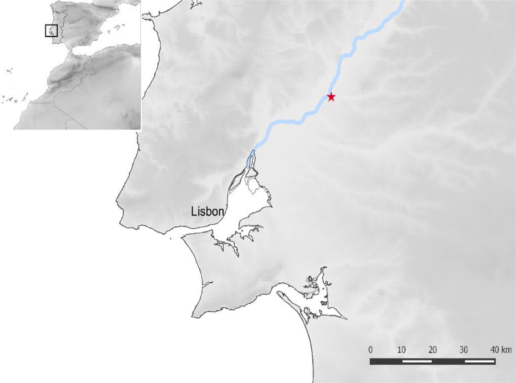
Location of Cabeço da Amoreira shell midden (indicated by the star), Muge, Tagus valley, Portugal. Peyroteo-Stjerna et al. (2022).

Radiocarbon dating of material from the Cabeço da Amoreira site, including bone, charcoal and shells, have produced dates of between 6500 and 5000 BC, consistent with a Mesolithic origin for the site, however, radiocarbon dating of collagen from the individual buried at the site yielded dates between 1529 and 1763 AD, and probably between 1631 and 1793, consistent with an Early Modern origin. 

Relationships between Early Modern Europe and Africa were dominated by the trans-Atlantic slave trade, which saw millions of people taken from Africa and shipped to European colonies in the New World, and to a lesser extent Europe itself. Portugal is estimated to have directly imported 2-3000 African slaves per year between the fifteenth and nineteenth centuries. Most of these remained enslaved their whole lives, though some were freed and able to live relatively independent lives, albeit very much at the bottom of the social scale. 

Because mitochondrial DNA is found in the mitochondria, organelles outside the cell nucleus, it is passed directly from mother to child without being sexually recombined each generation, enabling precise estimations of when individuals shared common ancestors, at least through the female line; this is known as the female haplogroup. It is also possible to trace direct ancestry through the male line, using DNA from the Y chromosome, which is passed directly from father to son without sexual recombination; this is known as the male haplogroup. Since everyone has mitochondria, it is possible to determine the female haplogroup of all Humans, but generally only males have a Y chromosome and can be assigned to a male haplogroup.

Genetic analysis of the Cabeço da Amoreira individual established that he had a Y chromosome, indicating that he was male. It was also possible to determine both his male haplogroup. He was found to belong to the E1b1a male haplogroup, which is the most widespread in sub-Saharan Africa, being commonly found in Nigeria, Congo, Cameroon, Gabon, Guinea-Bissau, and among Bantu-speakers in Southern Africa.

A principle component analysis based upon his entire recoverable genome revealed that Cabeço da Amoreira man showed a greater genomic similarity to West Africans than to other populations, and in particular, to people of Gambian or Mandinka origin. 

 
(A) Principal component analysis. Worldwide modern populations (circles coloured according to continent) and Cabeço da Amoreira man projected as a yellow, red outlined diamond. (B) Geographic distribution of the genetic affinity of the studied individual with modern African populations, measured by outgroup-f₃. The two highest f₃ scores are depicted with diamonds. Peyroteo-Stjerna et al. (2022).

Peyroteo-Stjerna et al. next looked for alleles (gene variants) associated with sub-Saharan populations, finding that Cabeço da Amoreira man had a number of alleles which would further support an African origin, notably the FY*B allele, which is associated with resilience to Malaria, and a number of skin pigmentation alleles, namely MFSD12 rs10424065; DDB1 rs11230664; OCA2 rs1800404; SLC45A2 rs16891982; and HERC2 rs6497271, which are more commonly associated with sub-Saharan African populations than with Europeans (skin pigmentation is complicated, genetically speaking, and it is not possible to directly determine someone's exact skin tone from their genome at the current time, but it is possible to associate allele abundances with specific populations). Cabeço da Amoreira man also lacked the alleles for lactase persistence (i.e. retaining the ability to digest milk into adult life), sugesting that he was lactose intolerant, something more common in Africans than Europeans.

A stable isotope analysis for carbon and oxygen isotopes, based upon bone collagen from Cabeço da Amoreira man, suggested that when he was growing up his diet comprised largely C₄ Plants, supplemented with seafood. A diet of C₄ Plants is not at all typical for Portugal (or elsewhere in Europe) in the Early Modern period, although it would have been common in parts of West Africa, notably the Sahel Region (which reaches the coast in the Senegambia region and southern Mauritania), where the principal crops for the time would have been Sorghum and Millet, both of which are C₄ Plants. Further south, in the West African forest zone, the principal crops were Rice (a C₄ Plant) in the west and a more mixed vegecultural diet (also based around C₄ Plants) in the east. Therefore, the C₄ Plant component of Cabeço da Amoreira man's diet makes it likely that he came from the Sahel region, and the seafood component further ties him to the Senegambia and Mauritania region.

 
Estimated area of origin of Cabeço da Amoreira man (mug019) in West Africa and place of burial in Portugal. Traditional plant food-producing systems in West Africa. Peyroteo-Stjerna et al. (2022).

Around 35 000 slaves were brought to Portugal from Africa between 1514 and 1866. Records of these movements are fairly complete after 1750, but older records are somewhat patchy, making the origin of Cabeço da Amoreira man difficult to reconstruct in this way. However, it is known that slaves were brought to Portugal from predominantly from Guinea-Bissau and The Gambia, with smaller numbers arriving from the Cape Verde islands, Princes Island and São Tomé, Bance Island (Sierra Leone), the Gold Coast (Ghana), Senegal and Whydah (on the coast of modern Benin). 

Most slaves in Portugal during this period would have been baptised as Christians, and buried in Christian burial grounds. However, there are records of slaves being buried in other ways, including by roadsides, in wastelands or in Olive groves. The Church generally kept good records of births, deaths, marriages, and baptisms during this period, for all social classes including slaves, which offered some hope of discovering the identity of Cabeço da Amoreira man. Peyroteo-Stjerna et al. were able to identify two deaths of interest in the Cabeço da Amoreira area in the seventeenth century, the first of an unnamed slave on 5 May 1633, for whom no burial location is listed, and the second of the murder of a man named João at Arneiro da Amoreira on 1 November 1676; João is described as being brown skinned, which may indicate that he was of mixed origins, but he was buried in a churchyard, so presumably was not Cabeço da Amoreira man.

One notable feature of the Cabeço da Amoreira burial is that the body does not appear to have been buried hastily, but rather laying upon a bed of sand which had been used to line the grave, something not seen in Mesolithic shell midden burials (the difference was noted at the time of excavation, but the significance of this, understandably, was not realised).This implies that the burial at this location was planned and carefully executed, rather than being the hurried disposal of the body of a slave or murder victim.

Shell midden burials, both ancient and modern, are known from the Senegambia region, and are still sometimes practiced among Serer fishermen in the Saloum Delta. Here, some families maintain temporary settlements on islands deep within the delta, which are used for four-to-five months each year, when shellfish are harvested. Since these sites are essentially located on shifting sandbanks, the shell middens that build up their form stable hardgrounds, which can be used for purposed such as supporting structures and burying anyone who dies while the temporary villages are in use.

 
Modern cemetery on a shell midden, at Fadiouth in the Saloum Delta, Senegal. Hardy et al. (2015).

This does not unequivocally tie the Cabeço da Amoreira burial to the Senegambia region, but does create a plausible scenario in which members of a community transplanted to Portugal, who had practiced shell midden burials in their homeland, might have chosen to recreate the practice in their new environment.

See also...


Follow Sciency Thoughts on Facebook.

Follow Sciency Thoughts on Twitter.