Showing posts with label Gorda Plate. Show all posts

Sunday, 8 December 2024

Magnitude 7.0 Earthquake off the coast of Northern California.

The United States Geological Survey recorded a Magnitude 7.0 Earthquake at a depth of about 10.0 km a little  over 50 km off Cape Mendocino in Humboldt County, California, slightly before 10.45 am local time (slightly before 6.45 pm GMT) on Thursday 5 December 2024. There are no reports of any casualties associated with this event, but the size and location of the Earthquake led to a tsunami being issued, advising about half a million people in California to seek high ground (in the event no tsunami was recorded), and minor damage to highways and buildings were recorded in several places, as well as disruption to power networks which left about 10 000 people in Humbolt County without power. The initial Earthquake has been followed by a large number of aftershocks, with the USGS estimating there is a 5% chance of another quake with a Magnitude of 6.0 or greater occurring in the same area within a week, and a 34% chance of a quake with a Magnitude of 5.0 or greater occurring.

The approximate location of the 5 December 2024 California Earthquake. USGS.

California is extremely prone to Earthquakes due to the presence of the San Andreas Fault, a tectonic plate margin that effectively bisects the state. The west of California, including Santa Barbara and Los Angeles, is located on the Pacific Plate, and is moving to the northwest. The east of California, including Fresno and Bakersfield is on the North American Plate, and is moving to the southeast. The plates do not move smoothly past one-another, but constantly stick together then break apart as the pressure builds up. This has led to a network of smaller faults that criss-cross the state, so that Earthquakes can effectively occur anywhere.

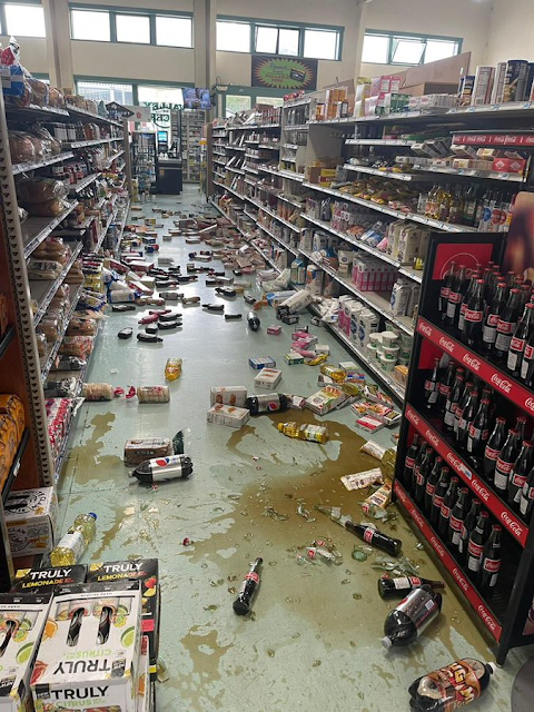
Goods knocked from shelves in Hoby's Market & Deli in Scotia, California, following a Magnitude 7.0 Earthquake on 5 December 2024. Dylan McNeil/The Times Standard/AP.

However, the 5 December 2024 Earthquake happened close to the southern part of the Mendocino Fracture Zone, a westward extension of the San Andreas Fault, where the Gorda Plate to the north is moving westward relative to the Pacific Plate to the south. Along this boundary the rocks of the two plates continuously stick together, then become stressed as the motion of the two plates draws them apart. This stress builds up until the rocks are forcibly snapped apart, which we experience as Earthquakes.

A crack is seen on Blue Slide Road in Rio Dell, California, following a Magnitude 7.0 Earthquake on 5 December 2024. City of Rio Dell/ABC News.

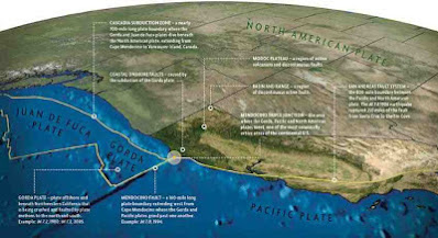
The Gorda Plate, along with the Explorer and Juan de Fuca Plates are remnants of an ancient oceanic plate, the Fallaron Plate which has almost completely disappeared beneath North America. The Fallaron Plate formerly diverged from the Pacific Plate along the Fallaron Ridge, but as the plate has been subducted both it and the ridge have broken up. The remnants of the plate are now the Explorer Plate in the north, then the Juan de Fuca Plate, then the Gorda Plate in the south. This borders onto the Pacific Plate along the Mendocino Fracture Zone, which extends on land as the San Andreas Fault.

North of California the San Andreas Fault becomes the Mendocino Fracture Zone. USGS.

Witness accounts of quakes can help geologists to understand these events and the rock structures that cause them. If you felt this quake (or if you were in the area but did not, which is also useful information) you can report it to the USGS here. 

See also...

Sunday, 1 January 2023

Magnitude 5.4 Earthquake beneath Humboldt County, California.

The United States Geological Survey recorded a Magnitude 5.4 Earthquake at a depth of about 27.8 km roughly 15 km to the southeast of the city of Rio Dell in Humboldt County, California, at about 10.35 am local time (about 6.35 pm GMT) on Sunday 1 January 2023. There are no reports of any damage or casualties associated with this event, but some transport routes were temporarily closed while safety inspections were carried out.

The approximate location of the 1 January 2023 California Earthquake. USGS.

California is extremely prone to Earthquakes due to the presence of the San Andreas Fault, a tectonic plate margin that effectively bisects the state. The west of California, including Santa Barbara and Los Angeles, is located on the Pacific Plate, and is moving to the northwest. The east of California, including Fresno and Bakersfield is on the North American Plate, and is moving to the southeast. The plates do not move smoothly past one-another, but constantly stick together then break apart as the pressure builds up. This has led to a network of smaller faults that criss-cross the state, so that Earthquakes can effectively occur anywhere.

However, the 1 January 2023 Earthquake happened close to the southern part of the Mendocino Fracture Zone, a westward extension of the San Andreas Fault, where the Gorda Plate to the north is moving westward relative to the Pacific Plate to the south. Along this boundary the rocks of the two plates continuously stick together, then become stressed as the motion of the two plates draws them apart. This stress builds up until the rocks are forcibly snapped apart, which we experience as Earthquakes.

Map showing the progress of the San Andreas Fault to the north, where it becomes the Gorda Plate subduction zone. Humboldt State University.

The Gorda Plate, along with the Explorer and Juan de Fuca Plates are remnants of an ancient oceanic plate, the Fallaron Plate which has almost completely disappeared beneath North America. The Fallaron Plate formerly diverged from the Pacific Plate along the Fallaron Ridge, but as the plate has been subducted both it and the ridge have broken up. The remnants of the plate are now the Explorer Plate in the north, then the Juan de Fuca Plate, then the Gorda Plate in the south. This borders onto the Pacific Plate along the Mendocino Fracture Zone, which extends on land as the San Andreas Fault.

North of California the San Andreas Fault becomes the Mendocino Fracture Zone. USGS.

Witness accounts of quakes can help geologists to understand these events and the rock structures that cause them. If you felt this quake (or if you were in the area but did not, which is also useful information) you can report it to the USGS here. 

See also...

Follow Sciency Thoughts on Facebook.

Follow Sciency Thoughts on Twitter.


Friday, 23 December 2022

Two confirmed fatalities following Magnitude 6.4 Earthquake off the coast of northern California.

The United States Geological Survey recorded a Magnitude 6.4 Earthquake at a depth of about 17.9 km roughly 5 km off the coast of the city of Humboldt County, California, slightly before 2.35 am local time (slightly before 10.35 am GMT) on Tuesday 20 December 2022. Two people are now known to have died following this event, although both are described as having been elderly, and to have had pre-existing medical conditions exasperated by the event. Another 17 people were injured during the Earthquake, with a number of properties damaged. About 70 000 households and businesses in Humboldt County were left without power following the event. The Earthquake was felt across most of California and Oregon, as well as in parts of Washington State, Idaho, Nevada, and Arizona.

Damage to a home in the city of Rio Dell in Humboldt County, California, following an Earthquake on 20 December 2022. Godofredo Vásquez/AP.

California is extremely prone to Earthquakes due to the presence of the San Andreas Fault, a tectonic plate margin that effectively bisects the state. The west of California, including Santa Barbara and Los Angeles, is located on the Pacific Plate, and is moving to the northwest. The east of California, including Fresno and Bakersfield is on the North American Plate, and is moving to the southeast. The plates do not move smoothly past one-another, but constantly stick together then break apart as the pressure builds up. This has led to a network of smaller faults that criss-cross the state, so that Earthquakes can effectively occur anywhere.

The approximate location of the 20 December 2022 California Earthquake. USGS.

However, the 20 December 2022 Earthquake happened close to the southern part of the Mendocino Fracture Zone, a westward extension of the San Andreas Fault, where the Gorda Plate to the north is moving westward relative to the Pacific Plate to the south. Along this boundary the rocks of the two plates continuously stick together, then become stressed as the motion of the two plates draws them apart. This stress builds up until the rocks are forcibly snapped apart, which we experience as Earthquakes.

Map showing the progress of the San Andreas Fault to the north, where it becomes the Gorda Plate subduction zone. Humboldt State University.

The Gorda Plate, along with the Explorer and Juan de Fuca Plates are remnants of an ancient oceanic plate, the Fallaron Plate which has almost completely disappeared beneath North America. The Fallaron Plate formerly diverged from the Pacific Plate along the Fallaron Ridge, but as the plate has been subducted both it and the ridge have broken up. The remnants of the plate are now the Explorer Plate in the north, then the Juan de Fuca Plate, then the Gorda Plate in the south. This borders onto the Pacific Plate along the Mendocino Fracture Zone, which extends on land as the San Andreas Fault.

North of California the San Andreas Fault becomes the Mendocino Fracture Zone. USGS.

Witness accounts of quakes can help geologists to understand these events and the rock structures that cause them. If you felt this quake (or if you were in the area but did not, which is also useful information) you can report it to the USGS here. 

See also...


Follow Sciency Thoughts on Facebook.

Follow Sciency Thoughts on Twitter. 


Monday, 20 December 2021

Magnitude 6.2 Earthquake off the coast of northern California.

The United States Geological Survey recorded a Magnitude 7.2 Earthquake at a depth of about 15.2 km roughly 35 km off the coast of the city of Humboldt County, California, at about 12.10 pm local time (about 8.10 pm GMT) on Monday 20 December 2021. The Earthquake is reported to have caused some minor damage to buildings and some small landslips, but there are no reports of any casualties at this time.

 
Goods knocked from shelves in a grocery store in Ferndale, California, following an Earthquake on 20 December 2021. Caroline Titus/Twitter.

California is extremely prone to Earthquakes due to the presence of the San Andreas Fault, a tectonic plate margin that effectively bisects the state. The west of California, including Santa Barbara and Los Angeles, is located on the Pacific Plate, and is moving to the northwest. The east of California, including Fresno and Bakersfield is on the North American Plate, and is moving to the southeast. The plates do not move smoothly past one-another, but constantly stick together then break apart as the pressure builds up. This has led to a network of smaller faults that criss-cross the state, so that Earthquakes can effectively occur anywhere.

 
The approximate location of the 20 December 2021 California Earthquake. USGS.

However the 20 December 2021 Earthquake happened on the southern part of the Mendocino Fracture Zone, a westward extension of the San Andreas Fault, where the Gorda Plate to the north is movingw westward relative to the Pacific Plate to the south. Along this boundary the rocks of the two plates continuously stick together, then become stressed as the motion of the two plates draws them apart. This stress builds up until the rocks are forcibly snapped apart, which we experience as Earthquakes.
 
 
Map showing the progress of the San Andreas Fault to the north, where it becomes the Gorda Plate subduction zone. Humboldt State University.
 
The Gorda Plate, along with the Explorer and Juan de Fuca Plates are remnants of an ancient oceanic plate, the Fallaron Plate which has almost completely disappeared beneath North America. The Fallaron Plate formerly diverged from the Pacific Plate along the Fallaron Ridge, but as the plate has been subducted both it and the ridge have broken up. The remnants of the plate are now the Explorer Plate in the north, then the Juan de Fuca Plate, then the Gorda Plate in the south. This borders onto the Pacific Plate along the Mendocino Fracture Zone, which extends on land as the San Andreas Fault. 
 
North of California the San Andreas Fault becomes the Mendocino Fracture Zone. USGS.
  
Witness accounts of quakes can help geologists to understand these events and the rock structures that cause them. If you felt this quake (or if you were in the area but did not, which is also useful information) you can report it to the USGS here. 
 
See also...


Follow Sciency Thoughts on Facebook.

Follow Sciency Thoughts on Twitter.


Wednesday, 11 March 2020

Magnitude 5.8 Earthquake off the coast of northern California.

The United States Geological Survey recorded a Magnitude 5.8 Earthquake at a depth of about 3.2 km roughly 69 km off the coast of the city of Eureka in Humboldt County, California, slightly before 8.00 pm local time on Sunday 8 March 2020 (slightly before 3.00 am on Monday 9 March GMT). There are no reports of any damage or injuries relating to this quake, but people have reported feeling it across much of northern California and southern Oregon.

The approximate location of the 8 March 2020 Eureka Earthquake. USGS.

California is extremely prone to Earthquakes due to the presence of the San Andreas Fault, a tectonic plate margin that effectively bisects the state. The west of California, including Santa Barbara and Los Angeles, is located on the Pacific Plate, and is moving to the northwest. The east of California, including Fresno and Bakersfield is on the North American Plate, and is moving to the southeast. The plates do not move smoothly past one-another, but constantly stick together then break apart as the pressure builds up. This has led to a network of smaller faults that criss-cross the state, so that Earthquakes can effectively occur anywhere.

However the  8 March 2020 Earthquake happened on the southern part of the Mendocino Fracture Zone, a westward extension of the San Andreas Fault, where the Gorda Plate to the north is movingw westward relative to the Pacific Plate to the south. Along this boundary the rocks of the two plates continuously stick together, then become stressed as the motion of the two plates draws them apart. This stress builds up until the rocks are forcibly snapped apart, which we experience as Earthquakes.

 Map showing the progress of the San Andreas Fault to the north, where it becomes the Gorda Plate subduction zone. Humboldt State University.

The Gorda Plate, along with the Explorer and Juan de Fuca Plates are remnants of an ancient oceanic plate, the Fallaron Plate which has almost completely disappeared beneath North America. The Fallaron Plate formerly diverged from the Pacific Plate along the Fallaron Ridge, but as the plate has been subducted both it and the ridge have broken up. The remnants of the plate are now the Explorer Plate in the north, then the Juan de Fuca Plate, then the Gorda Plate in the south. This borders onto the Pacific Plate along the Mendocino Fracture Zone, which extends on land as the San Andreas Fault.  

 North of California the San Andreas Fault becomes the Mendocino Fracture Zone. USGS.
 
Witness accounts of quakes can help geologists to understand these events and the rock structures that cause them. If you felt this quake (or if you were in the area but did not, which is also useful information) you can report it to the USGS here.

See also...

https://sciencythoughts.blogspot.com/2019/12/urechis-caupo-thousands-of-fat.htmlhttps://sciencythoughts.blogspot.com/2019/11/rockfall-kills-two-climbers-in-sierra.html
https://sciencythoughts.blogspot.com/2019/08/magnitude-590-earthquake-in-inyo-county.htmlhttps://sciencythoughts.blogspot.com/2019/08/rockfall-kills-three-on-californian.html
https://sciencythoughts.blogspot.com/2019/07/second-major-earthquake-hits-kern.htmlhttps://sciencythoughts.blogspot.com/2019/07/magnitude-64-earthquake-in-kern-county.html
Follow Sciency Thoughts on Facebook.