Showing posts with label California. Show all posts

Thursday, 9 January 2025

At least five dead and more than 2000 homes destroyed as a series of wildfires sweep across Los Angeles County.

Five people have been confirmed dead and others may have lost their lives as more than 2000 homes have been destroyed in a series of wildfires which have swept across Los Angeles County in Southern California since Tuesday 7 January 2025. Around 180 000 further people have been ordered to evacuate their homes, with another 200 000 warned this may be necessary, amid concerns that these will also be lost, many of them in Los Angeles's wealthiest suburbs. Around 400 000 people have had their electricity supplies either disrupted or cut off completely.

A fire at the intersection of Temescal Canyon and Pacific Coast Highway in the Pacific Palisades neighbourhood of Los Angeles on 7 January 2025. Robyn Beck/AFP/Getty Images.

The second fire reported, now named the Palisades Fire, was reported at about 10.30 am on 7 January in the Palisades Hills to the northwest of Santa Monica. This has subsequently spread to cover an area of about 55 km², affecting the communities of Santa Monica, Malibu, and Calabasas, with initial efforts to contain it hampered by high winds, which both helped the fire to spread quickly and prevented fire fighting aircraft from approaching the area. The problems faced by firefighters worsened as the area's fire hydrant system became exhausted by the demand being placed upon it, causing pressure to fall and fire hoses to run dry.

Firefighters attempting to control the Palisades Fire in western Los Angeles County on 7 January 2025. Kyle Grillot/Bloomberg.

At about 6.20 pm the Eaton Fire was reported in the Eaton Canyon Falls area to the northeast of Pasadena. This fire has now spread to cover an area of about 40 km², again with high winds and an over-used fire hydrant system severely hampering efforts to contain the fire. All five known fatalities have been caused by the Eaton Fire in the Altadena neighbourhood, although local officials are warning that there are probably many more dead around the county.

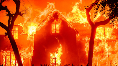
A burning home in the Altadena neighbourhood of Pasadena on 8 January 2024. Josh Edelson/AFP/Getty Images.

At about the 10.30 the Hurst Fire was reported in the San Fernando Valley to the north of Los Angeles. This has spread to cover almost 3 km² of land and is only partially controlled, leading to a large area being evacuated. Some witnesses have reported seeing an explosion at an electrical distribution centre, possibly caused by high winds blowing power cables loose, but this is still under investigation,

Westward view of the Hurst Fire as seen from the Oakridge Manufactured Home Park. P Rivas/Wikimedia Commons.

The Lidia Fire was reported slightly after 6.00 am on Wednesday 8 January, close to the town of Ravenna to the north of the Angeles National Forest. This fire has spread to cover about 1.5 km² of land,  and is only partially under control, provoking some evacuations. The Woodley Fire was reported at 6.15 am on Wednesday 8 January in the Woodley Recreation Area,  to the north of Encino. This eventually burned about 121 400 m² of wood-  and parkland before being brought under control. The Sunset Fire was reported slightly before 6.00 pm on Wednesday 8 January, and has spread to cover 170 m² of land, provoking further evacuations and threatening some of Holywood's  most iconic landmarks. 

The fires affecting Los Angeles (and other parts of California) are largely a result of several years of unusually hot and dry weather, which in turn have been driven by rising global temperatures. However, they have also been driven by extremely strong Santa Ana winds, a form of katabaric (downhill) wind driven by the Californian landscape. The interior of California is elevated, and has a dry climate compared to coastal areas. During periods of cool weather high pressure zones can form in these dry highlands, and if these coincide with a low pressure system in coastal areas, then the winds flow downhill, gaining heat (and, typically, quite a bit of dust) before reaching lowland coastal areas.

Air from areas of high pressure inland flows toward sea level in Southern California. Paul Duginski/Los Angeles Times.

See also...

Sunday, 8 December 2024

Magnitude 7.0 Earthquake off the coast of Northern California.

The United States Geological Survey recorded a Magnitude 7.0 Earthquake at a depth of about 10.0 km a little  over 50 km off Cape Mendocino in Humboldt County, California, slightly before 10.45 am local time (slightly before 6.45 pm GMT) on Thursday 5 December 2024. There are no reports of any casualties associated with this event, but the size and location of the Earthquake led to a tsunami being issued, advising about half a million people in California to seek high ground (in the event no tsunami was recorded), and minor damage to highways and buildings were recorded in several places, as well as disruption to power networks which left about 10 000 people in Humbolt County without power. The initial Earthquake has been followed by a large number of aftershocks, with the USGS estimating there is a 5% chance of another quake with a Magnitude of 6.0 or greater occurring in the same area within a week, and a 34% chance of a quake with a Magnitude of 5.0 or greater occurring.

The approximate location of the 5 December 2024 California Earthquake. USGS.

California is extremely prone to Earthquakes due to the presence of the San Andreas Fault, a tectonic plate margin that effectively bisects the state. The west of California, including Santa Barbara and Los Angeles, is located on the Pacific Plate, and is moving to the northwest. The east of California, including Fresno and Bakersfield is on the North American Plate, and is moving to the southeast. The plates do not move smoothly past one-another, but constantly stick together then break apart as the pressure builds up. This has led to a network of smaller faults that criss-cross the state, so that Earthquakes can effectively occur anywhere.

Goods knocked from shelves in Hoby's Market & Deli in Scotia, California, following a Magnitude 7.0 Earthquake on 5 December 2024. Dylan McNeil/The Times Standard/AP.

However, the 5 December 2024 Earthquake happened close to the southern part of the Mendocino Fracture Zone, a westward extension of the San Andreas Fault, where the Gorda Plate to the north is moving westward relative to the Pacific Plate to the south. Along this boundary the rocks of the two plates continuously stick together, then become stressed as the motion of the two plates draws them apart. This stress builds up until the rocks are forcibly snapped apart, which we experience as Earthquakes.

A crack is seen on Blue Slide Road in Rio Dell, California, following a Magnitude 7.0 Earthquake on 5 December 2024. City of Rio Dell/ABC News.

The Gorda Plate, along with the Explorer and Juan de Fuca Plates are remnants of an ancient oceanic plate, the Fallaron Plate which has almost completely disappeared beneath North America. The Fallaron Plate formerly diverged from the Pacific Plate along the Fallaron Ridge, but as the plate has been subducted both it and the ridge have broken up. The remnants of the plate are now the Explorer Plate in the north, then the Juan de Fuca Plate, then the Gorda Plate in the south. This borders onto the Pacific Plate along the Mendocino Fracture Zone, which extends on land as the San Andreas Fault.

North of California the San Andreas Fault becomes the Mendocino Fracture Zone. USGS.

Witness accounts of quakes can help geologists to understand these events and the rock structures that cause them. If you felt this quake (or if you were in the area but did not, which is also useful information) you can report it to the USGS here

See also...

Wednesday, 7 August 2024

Magnitude 5.2 Earthquake in Kern County, California.

The United States Geological Survey recorded a Magnitude 5.2 Earthquake at a depth of about 11.7 km roughly 23 km to the southwest of Lamont in Kern County, California, slightly before 9.10 pm local time on Tuesday 6 August 2024 (slightly before 4.10 am on Wednesday 7 August, GMT). There are no reports of any damage or injuries relating to this quake, but people have reported feeling it across much of southern California.

The approximate location of the 6 August 2024 County Earthquake. USGS.

California is extremely prone to Earthquakes due to the presence of the San Andreas Fault, a tectonic plate margin that effectively bisects the state. The west of California, including Santa Barbara and Los Angeles, is located on the Pacific Plate, and is moving to the northwest. The east of California, including Fresno and Bakersfield is on the North American Plate, and is moving to the southeast. The plates do not move smoothly past one-another, but constantly stick together then break apart as the pressure builds up. This has led to a network of smaller faults that criss-cross the state, so that Earthquakes can effectively occur anywhere.

Tectonic boundaries and faults in California and the surrounding area. USGS.

Witness accounts of Earthquakes can help geologists to understand these events and the underlying structures that cause them. If you felt this quake (or if you were in the area but did not, which is also useful information) then you can report it to the United States Geological Survey here.

See also...

Wednesday, 3 April 2024

Fireball over California thought to have been caused by part of Chinese spacecraft re-entering atmosphere.

Witnesses across California between San Diego and Sacramento, as well as the Las Vegas in Nevada, have reported observing a bright fireball meteor at about 1.40 am local time (8.40 am GMT) on Tuesday 2 April 2024. The fireball is described as having moved from southwest to northeast, over the central part of the state. A fireball is defined as a meteor (shooting star) brighter than the planet Venus. These are typically caused by pieces of rock burning up in the atmosphere, but can be the result of man-made space-junk burning up on re-entry, as is believed to have been the case on this occasion.

The 2 April 2024 Fireball seen from Ontario, California. American Meteor Society.

The fireball is thought to have been caused by a part of a Chinese spacecraft which launched on 29 November 2022 re-entering the atmosphere. The Shenzhou 15 spacecraft caried three taikonauts (the Chinese equivalent of astronauts) to the Tiangong Space Station. The taikonauts returned to Earth on 3 June 2023 aboard the Shenzhou 15 re-entry module, the only portion of the craft designed to re-enter the atmosphere safely. The remaining portion of the spacecraft has been on a decaying orbit since this time, finally re-entering the atmosphere this week.

The portions of a Shenzhou spacecraft. Ilya Kharlamov/Wikimedia Commons.

See also... 

Monday, 4 March 2024

Promyrmekiaphila korematsui: A new species of Trapdoor Spider from California.

Cryptic species are species which resemble one-another physically yet are reproductively isolated from each other. While such species clusters can come about due to convergent evolution, the vast majority are closely related species which have become reproductively isolated, but which have not diverged morphologically, usually as a result of a physical barrier splitting a population, followed by genetic drift. This is particularly common among morphologically conservative groups with low distribution rates, such as Mygalomorphs (Tarantulas, Trapdoor Spiders etc.), which are large Spiders occupying silk-lined burrows, typically remaining at a single site for their entire lives. 

In a paper published in the journal Ecology and Evolution on 1 March 2024, James StarrettEmma JochimIris QuayleXavier Zahnle, and Jason Bond of the University of California, Davis, present the results of a genetic study of the Trapdoor Spider genus Promyrmekiaphila, which is known only from California, and describe a new species, the third within the genus.

The genus Promyrmekiaphila was first described in 1950 by the Swiss arachnologist and herpetologist Ehrenfried Schenkel to describe a morphotype of Trapdoor Spider found across California, which he named Promyrmekiaphila gertschi. This was later found to have previously been described by the French naturalist Eugène Simon as Aptostichus clathratus in 1891, though it was later recognised that the assignation of the species to the genus Aptostichus was wrong, and Schenkel's name Promyrmekiaphila was adopted, leading to the combination Promyrmekiaphila clathratus.

In 2007 and 2008 Amy Stockman and Jason Bond, then both at the Department of Biology at East Carolina University, carried out a study of the population of Promyrmekiaphila clathratus using mitochondrial DNA (mtDNA), coming to the conclusion that there were in fact two species within the genus, Promyrmekiaphila clathratus found throughout the coastal ranges in central and northern California, and a new species, which they named Promyrmekiaphila winnemem, which was found at the northern end of the Central Valley. 

However, Stockman and Bond recognised that a study based upon mtDNA alone had its limitations, and that there still remained the possibility of other, cryptic, species of Promyrmekiaphila being found in California. 

Starrett et al.'s new study is based upon a wider gene set. This identified a number of deeply separated lineages within the Promyrmekiaphila clathratus  population, although Starrett et al. decline to name these as new species at this time, reasoning that they are not yet sufficiently genetically different to be reproductively isolated. However, a small group of Spiders found close to the San Andreas Fault line, from mid-San Francisco Peninsula to the Diablo Range, east of Paicines, were found to comprise a sister group to the Promyrmekiaphila clathratus and Promyrmekiaphila winnemem pair, therefore clearly representing a new species.

This new species is named Promyrmekiaphila korematsui, in honour of Fred Toyosaburo Korematsu, who  was awarded the United States Presidential Medal of Freedom in 1998 in recognition of his lifelong dedication as a civil rights activist and his resistance to the  incarceration of Japanese Americans in concentration camps during World War II.

Promyrmekiaphila korematsui, male live habitus photographs, side and dorsal views. Starrett et al. (2024).

Promyrmekiaphila korematsui is found d in shaded ravines and along roadcuts in Oak woodland habitat. Its distribution overlaps with that of Promyrmekiaphila clathratus, which may have implications for evolution of the genus, although the small sample size available for the genus so far prevents any detailed  analysis at this time.

See also...