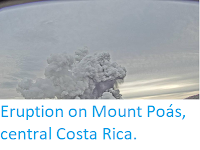
The Observatorio Vulcanológico y Sismológico de Costa Rica-Universidad Nacional reported
a small eruption on Rincón de la Vieja, an active volcano in Guanacaste Province.in the
northwest of the country, at about 12.15 pm local time on Friday 30 January 2020. This is the first eruption from the volcano since January 2019, and produced an ash column about 2 km high, and is the latest in a series of small eruptions on the volcano that started in September 2014

Ash column above Rincón de la Vieja on 30 January 2020. Observatorio Vulcanológico y Sismológico de Costa Rica-Universidad Nacional.
Rincón de la Vieja is a complex volcano (volcano with multiple eruptive
vents rather than a single crater at the top of a cone-shaped mountain)
rising to 1916 m above sea-level in Guanacaste Province in the northwest
of Costa Rica. It is located within the Rincón de la Vieja National Park,
where along with an associated hot spring system it forms an important
part of the local economy. Prior to the onset of activity in September
2014 the volcano had been inactive since September 2011, and the last
major eruption occurred in 1966. A small geothermal energy project, the
Las Pailas Geothermal Power Plant, runs on heat from underground rocks
associated with the volcanic complex.
Rincón de la Vieja forms part of the Cordillera de Guanacaste, a range of volcanic mountains
running through northern Costa Rica close to the border with Nicaragua and forming part of the Central
American Arc. These volcanoes are fuelled by the subduction of the Cocos
Plate, which underlies part of the east Pacific Ocean, beneath the
Caribbean Plate, on which Central America lies, along the Middle
American Trench, which lies off the south coast of the country. As the
Cocos Plate is subducted it is gradually melted by the heat and pressure
of the Earth's interior, with some more volatile minerals rising
through the overlying Caribbean Plate as volcanic magma.

Diagram showing the passage of the Cocos Plate beneath Costa Rica (not to scale). Carleton College.
See also...


Follow Sciency Thoughts on Facebook.