Showing posts with label Lombok. Show all posts

Sunday, 17 March 2019

Magnitude 5.5 Earthquake on Lombok triggers deadly landslide.

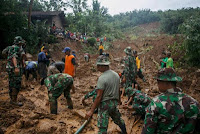
Two Malaysian tourists have been confirmed dead and at least 20 more have been injured, and several more are still missing, following a landslide at a waterfall on Lombok Island, Indonesia, popular with tourists, triggered by an Earthquake on Sunday 17 March 2019. The Earthquake was recorded by the United States Geological Survey as having a Magnitude of 5.5 and having occurred at a depth of 23.6 km, slightly before 2.10 pm local time (slightly before 7.10 am GMT), and was felt across the islands of Lombok and Bali. One of the dead has been named as Datin Tai Siew, the deputy executive editor-in-chief of Malaysian newspaper Sin Chew Daily.

Datin Tai Siew, the deputy executive editor-in-chief of the Chinese language Malasian newspaper Sin Chew daily, killed by an Earthquake-triggered landslide on Lombok on 17 March 2019. Bernama.

The Indo-Australian Plate, which underlies the Indian Ocean to the south of Java, Bali and Lombok, is being subducted beneath the Sunda Plate, a breakaway part of the Eurasian Plate which underlies the islands and neighbouring Sumatra, along the Sunda Trench, passing under the islands, where friction between the two plates can cause Earthquakes. As the Indo-Australian Plate sinks further into the Earth it is partially melted and some of the melted material rises through the overlying Sunda Plate as magma, fuelling the volcanoes of Java and neighbouring islands.

 Subduction along the Sunda Trench beneath Java, Bali and Lombok. Earth Observatory of Singapore.

Meanwhile, to the north of Lombok and eastwards through the Lesser Sunda Islands, the Eurasian Plate is also being subducted beneath the islands, creating a separate microplate. the Timor Plate, with subduction beneath it to both the south and the north.

The subduction zones beneath the Timor Microplate. Hamson (2004).
  
Witness accounts of Earthquakes can help geologists to understand these events, and the structures that cause them. The international non-profit organisation Earthquake Report is interested in hearing from people who may have felt this event; if you felt this quake then you can report it to Earthquake Report here.

 The approximate location of the 17 March 2019 Lombok Earthquake. USGS,

See also...

https://sciencythoughts.blogspot.com/2018/08/magnitude-69-earthquake-beneath-lombok.htmlhttps://sciencythoughts.blogspot.com/2018/07/magnitude-64-earthquake-beneath.html
https://sciencythoughts.blogspot.com/2018/01/landslide-kills-man-on-lombok-island.htmlhttps://sciencythoughts.blogspot.com/2017/02/magnitude-46-earthquake-to-south-of.html
https://sciencythoughts.blogspot.com/2016/09/thousands-evacuated-following-eruption.htmlhttps://sciencythoughts.blogspot.com/2015/11/flights-cancelled-to-and-from-lombok.html
Follow Sciency Thoughts on Facebook.

Tuesday, 7 August 2018

Magnitude 6.9 Earthquake beneath Lombok Island kills over a hundred people.

The United States Geological Survey recorded a Magnitude 6.9 Earthquake at a depth of 31 km beneath the northern part of Lombok Island in Indonesia slightly after 7.45 pm local time (slightly after 11.45 am GMT) on Sunday 5 August 2018. The event triggered a number of landslides and building collapses on Lombok and neighbouring islands, and is known to have killed at least 105 people, and injured more than 200 more, many of them seriously, as well as making over twenty thousand homeless. The event also destroyed a hotel in the volcanic Gili Islands, leaving over 2000 tourists without accommodation until they could be rescued, which is likely to have a lasting influence on the area's tourist industry.

Search and rescue teams in the remains of a collapsed mosque in Pemenang, North Lombok. AFP/Getty Images.

The Indo-Australian Plate, which underlies the Indian Ocean to the south of Java, Bali and Lombok, is being subducted beneath the Sunda Plate, a breakaway part of the Eurasian Plate which underlies the islands and neighbouring Sumatra, along the Sunda Trench, passing under the islands, where friction between the two plates can cause Earthquakes. As the Indo-Australian Plate sinks further into the Earth it is partially melted and some of the melted material rises through the overlying Sunda Plate as magma, fuelling the volcanoes of Java and neighbouring islands.

Subduction along the Sunda Trench beneath Java, Bali and Lombok. Earth Observatory of Singapore.
 
Meanwhile, to the north of Lombok and eastwards through the Lesser Sunda Islands, the Eurasian Plate is also being subducted beneath the islands, creating a separate microplate. the Timor Plate, with subduction beneath it to both the south and the north.
 
The subduction zones beneath the Timor Microplate. Hamson (2004).
 
Witness accounts of Earthquakes can help geologists to understand these events, and the structures that cause them. The international non-profit organisation Earthquake Report is interested in hearing from people who may have felt this event; if you felt this quake then you can report it to Earthquake Report here.

See also...

https://sciencythoughts.blogspot.com/2018/07/magnitude-64-earthquake-beneath.htmlhttps://sciencythoughts.blogspot.com/2018/01/landslide-kills-man-on-lombok-island.html
https://sciencythoughts.blogspot.com/2017/02/magnitude-46-earthquake-to-south-of.htmlhttps://sciencythoughts.blogspot.com/2016/09/thousands-evacuated-following-eruption.html
https://sciencythoughts.blogspot.com/2015/11/flights-cancelled-to-and-from-lombok.html
Follow Sciency Thoughts on Facebook.

Sunday, 29 July 2018

Magnitude 6.4 Earthquake beneath northern Lombok Island kills at least fourteen.

The United States Geological Survey recorded a Magnitude 6.4 Earthquake at a depth of 6.4 km benrath the northern part of Lombok Island in Indonesia slightly after 6.45 am  local time on Sunday 29 July 2018 (slightly after 10.45 pm on Saturday 28 July GMT) on Sunday 12 February 2017. The event was felt across most of Bali and Lombok islands, and eastern parts of Java, and there are fourteen  reported fatalities associated with this event, including at east one freign tourist, a Malasian National, at the time of writing, as well as over a hundred people injured and more than a thousand made homeless.

Buildings destroyed by an Earthquake beneath northern Lombok Island on 29 July 2018. AFP.

The Indo-Australian Plate, which underlies the Indian Ocean to the south of Java, Bali and Lombok, is being subducted beneath the Sunda Plate, a breakaway part of the Eurasian Plate which underlies the islands and neighbouring Sumatra, along the Sunda Trench, passing under the islands, where friction between the two plates can cause Earthquakes. As the Indo-Australian Plate sinks further into the Earth it is partially melted and some of the melted material rises through the overlying Sunda Plate as magma, fuelling the volcanoes of Java and neighbouring islands.

 Subduction along the Sunda Trench beneath Java, Bali and Lombok. Earth Observatory of Singapore.

Meanwhile, to the north of Lombok and eastwards through the Lesser Sunda Islands, the Eurasian Plate is also being subducted beneath tje islands, creating a separate microplate. the Timor Plate, with subduction beneath it to both the south and the north.

 The subduction zones beneath the Timor Microplate. Hamson (2004).

Witness accounts of Earthquakes can help geologists to understand these events, and the structures that cause them. The international non-profit organization Earthquake Report is interested in hearing from people who may have felt this event; if you felt this quake then you can report it to Earthquake Report here.
 
The approximate location of the 29 July 2018 Lombok Earthquake. USGS,
 
See also...
 
https://sciencythoughts.blogspot.com/2018/01/landslide-kills-man-on-lombok-island.htmlhttps://sciencythoughts.blogspot.com/2017/02/magnitude-46-earthquake-to-south-of.html
https://sciencythoughts.blogspot.com/2016/09/thousands-evacuated-following-eruption.htmlhttps://sciencythoughts.blogspot.com/2015/11/flights-cancelled-to-and-from-lombok.html
Follow Sciency Thoughts on Facebook.

Wednesday, 10 January 2018

Landslide kills man on Lombok Island, Indonesia.

A man has died after being caught in a landslide on Lombok Island in Indonesia on Wednesday 10 January 2017. Amaq Riki, 35, was travelling in a car with two friends near Pelawangan in the Sembalun Subdistrict at about 6.30 am, when they encountered a previous landslip. They were stopped at the site when they were hit by a second event.

A team clearing a road after a landslide near Pelawangan, Lombok, on 10 January 2017. NTB Disaster Mitigation.

The event happened after heavy rainfall in the area. Landslides are a common problem after severe weather events, as excess pore water pressure can overcome cohesion in soil and sediments, allowing them to flow like liquids. Approximately 90% of all landslides are caused by heavy rainfall. Lombok has a tropical climate with rainy and dry seasons. The rainy season lasts from October to April with November being the wettest month, but January still often receiving around a 100 mm of rainfall.

See also...

http://sciencythoughts.blogspot.co.uk/2017/12/magnitude-65-earthquake-beneath-west.htmlhttp://sciencythoughts.blogspot.co.uk/2017/11/flights-to-and-from-bali-cancelled.html
http://sciencythoughts.blogspot.co.uk/2017/11/magnitude-54-earthquake-beneath-west.htmlhttp://sciencythoughts.blogspot.co.uk/2017/10/landslide-kills-four-in-west-java.html
http://sciencythoughts.blogspot.co.uk/2017/09/thousands-evacuated-from-area-around.htmlhttp://sciencythoughts.blogspot.co.uk/2017/03/magnitude-55-earthquake-beneath.html
Follow Sciency Thoughts on Facebook.

Monday, 13 February 2017

Magnitude 4.6 Earthquake to the south of Bali and Lombok islands.

The United States Geological Survey recorded a Magnitude 4.6 Earthquake at a depth of72.9 km about 68 km to the southwest of Lombok Island in Indonesia at about 12.25  pm local time (about 4.25 am GMT) on Sunday 12 February 2017. The event was felt across most of Bali and Lombok islands, but there are no reports of any damage or injuries.

The approximate location of the12 February 2017 Indonesia Earthquake. USGS.

The Indo-Australian Plate, which underlies the Indian Ocean to the south of Java, Bali and Lombok, is being subducted beneath the Sunda Plate, a breakaway part of the Eurasian Plate which underlies the islands and neighbouring Sumatra, along the Sunda Trench, passing under the islands, where friction between the two plates can cause Earthquakes. As the Indo-Australian Plate sinks further into the Earth it is partially melted and some of the melted material rises through the overlying Sunda Plate as magma, fuelling the volcanoes of Java and neighbouring islands.

 Subduction along the Sunda Trench beneath Java, Bali and Lombok. Earth Observatory of Singapore.

Witness accounts of Earthquakes can help geologists to understand these events, and the structures that cause them. The international non-profit organisation Earthquake Report is interested in hearing from people who may have felt this event; if you felt this quake then you can report it to Earthquake Report here.

 See also...

http://sciencythoughts.blogspot.co.uk/2016/09/thousands-evacuated-following-eruption.html
http://sciencythoughts.blogspot.co.uk/2017/02/landslides-kill-twelve-on-northern-bali.html
 
http://sciencythoughts.blogspot.co.uk/2015/07/indonesian-airports-closed-by-volcanic.html
http://sciencythoughts.blogspot.co.uk/2015/11/flights-cancelled-to-and-from-lombok.html
http://sciencythoughts.blogspot.co.uk/2014/05/flights-across-australia-disrupted.html

Follow Sciency Thoughts on Facebook.

Thursday, 29 September 2016

Thousands evacuated following eruption on Mount Rinjani, Lombok.

The Pusat Vulkanologi dan Mitigasi Bencana Geologi (which monitors volcanoes and other geohazards in Indonesia) has set up a three kilometer exclusion zone around Mount Rinjani,  an active volcano on northern Lombok island, on Tuesday 27 September 2016. The eruption came without warning, and produced an ash column two kilometers in height from the Gunung Barujari crater, which first erupted in 1994. At the time of the eruption over a thousand tourists were in the Mount Rinjani National Park, which surrounds the volcano, including 639 foreign nationals. Initial reports suggested that some of these were missing and may have been trapped by the eruption, but all have now been found and evacuated, including some who reportedly initially sought to avoid local authorities in order to observe and document the eruption.

The 27 September 2016 eruption on Mount Rinjani. Antara Foto/Reuters.

The Indo-Australian Plate, which underlies the Indian Ocean to the south of Java, Bali and Lombok, is being subducted beneath the Sunda Plate, a breakaway part of the Eurasian Plate which underlies the islands and neighbouring Sumatra, along the Sunda Trench, passing under the islands, where friction between the two plates can cause Earthquakes. As the Indo-Australian Plate sinks further into the Earth it is partially melted and some of the melted material rises through the overlying Sunda Plate as magma, fuelling the volcanoes of Java and neighbouring islands.

The approximate location of Mount Rinjani. Google Maps.

Subduction along the Sunda Trench beneath Java, Bali and Lombok. Earth Observatory of Singapore.

See also...
 
http://sciencythoughts.blogspot.co.uk/2016/06/flooding-and-landslides-kill-forty.htmlFlooding and landslides kill forty seven in Central Java.                                               Forty seven people have been confirmed dead and another fifteen are missing after a series of landslides and flash floods in Central Java, Indonesia, this week. Landslides are a common problem after severe...
http://sciencythoughts.blogspot.co.uk/2016/02/magnitude-63-earthquake-beneath-palau.htmlMagnitude 6.3 Earthquake beneath Palau Sumba, Indonesia.                               The United States Geological Survey recorded a Magnitude 6.3 Earthquake at a depth of 28 km...
http://sciencythoughts.blogspot.co.uk/2015/11/landslide-believed-to-have-killed-one.htmlLandslide believed to have killed one person in West Java, Indonesia.                              One person is missing and believed to be dead following a landslide that hit the Karangmukti...
Follow Sciency Thoughts on Facebook.

Tuesday, 3 November 2015

Flights cancelled to and from Lombok and Bali following eruption on Mount Rinjani.

Authorities in Indonesia have been forced to close airports in Lombok and Bali following a series of eruptions on Mount Rinjani, an active volcano on Lombok. There are no reports of any damage or casualties associated with the eruptions, however volcanic ash is extremely hazardous to aircraft in a number of ways. At its most obvious it is opaque, both visually and to radar. Then it is abrasive, ash particles physically scour aircraft, damaging components and frosting windows. However the ash is most dangerous when it is sucked into jet engines, here the high temperatures can melt the tiny silica particles, forming volcanic glass which then clogs engine. When this happens the only hope the aircraft has is to dive sharply, in the hope that cold air passing through the engine during the descent will cause the glass to shatter, allowing the engine to be restarted.
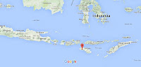

Mount Rinjani has been inactive since 2010, but on Sunday 25 October 2015 the Pusat Vulkanologi dan Mitigasi Bencana Geologi (which monitors volcanoes and other geohazards in Indonesia) reported a small eruption that produced a plume rising 200 m above the summit of the volcano and ashfalls on the southwestern flank. This was followed by much larger eruptions on 26, 28 and 31 October, which the Darwin Volcanic Ash Advisory Centre recorded as producing plumes 3-4 km high and drifting 45-75 km to the southwest. All flights from Lombok are currently cancelled until at least Tuesday 3 November, access to the volcano, a popular tourist attraction, has been suspended and local authorities are making contingency plans for an evacuation of nearby communities if the situation grows worse.

The approximate location of Mount Rinjani. Google Maps.

The Indo-Australian Plate, which underlies the Indian Ocean to the south of Java, Bali and Lombok, is being subducted beneath the Sunda Plate, a breakaway part of the Eurasian Plate which underlies the islands and neighbouring Sumatra, along the Sunda Trench, passing under the islands, where friction between the two plates can cause Earthquakes. As the Indo-Australian Plate sinks further into the Earth it is partially melted and some of the melted material rises through the overlying Sunda Plate as magma, fuelling the volcanoes of Java and neighbouring islands.

Subduction along the Sunda Trench beneath Java, Bali and Lombok. Earth Observatory of Singapore.

See also...

Authorities in Indonesia have been forced to close several airports in East Java and Bali following a series of eruptions on Mount Raung, an active volcano in...


Four people have been confirmed dead and another nine are missing following an explosion on a...


On 7 April 2015 the Darwin Volcanic Ash Advisory Centre reported an ash cloud rising 7 km above the island, which then drifted to the northwest. This is the first eruptive activity on the volcano reported since...

Follow Sciency Thoughts on Facebook.