Showing posts with label Philippine Sea Plate. Show all posts

Friday, 26 December 2025

Magnitude 6.1 Earthquake on the east coast of Taiwan.

The Taiwan Central Weather Bureau has reported a Magnitude 6.1 Earthquake at a depth of 11.9 km, 10.1 km to the north of the city of Taitung on the east coast of Taiwan, slightly after 5.45 pm local time (slightly after 9.45 am GMT on Wednesday 24 December 2025. There are no reports of any damage or casualties following this event, but it was felt across much of the island.

The approximate location of the 24 December 2025 Taiwan Earthquake. USGS.

Taiwan has a complex tectonic setting, lying on the boundary between the Eurasian and Philippine Plates, with the Eurasian Plate being subducted beneath the Philippine Plate in the South and the Philippine Plate being subducted beneath the Eurasian in the East. Subduction is not a smooth process even in simple settings, with plates typically sticking together as pressure from tectonic expansion elsewhere builds up, then suddenly breaking apart and shifting abruptly, causing Earthquakes.

The motion of the tectonic plates beneath Taiwan. The University of Memphis.

See also...

Friday, 10 May 2019

Magnitude 6.3 Earthquake off the coast of Kyūshū Island, Japan.

The Japan Meteorological Agency recorded a Magnitude 6.3 Earthquake at a depth of about 20 km, off the east coast of the Miyazaki Prefecture on Kyūshū Island, slightly before 8.50 am Japan Standard Time on Friday 10 May 2019 (slightly before 11.50 pm on Friday 9 May GMT). The event was felt across much of western Japan, with the jolt being quite severe in the cities of Miyazaki and Miyakonojo, though only minor damage has been reported, with one person suffering non-life-threatening injuries.

A water suply pipe damaged by the 10 May 2019 Miyazaki Earthquake. Miyazaki City Waterworks and Sewerage Bureau/Kyodo News.

Japan has a complex tectonic environment with four plates underlying parts of the Islands; in addition to the Pacific in the east and the Othorsk in the North, there are the Philipine Plate to the south and the Eurasian Plate to the West. Kyūshū Island lies at the northeast end of the Ryukyu Island Arc, which sits on top of the boundary between the Eurasian and Philippine Plates. The Philippine Plate is being subducted beneath the Eurasian Plate, in the Ryukyo Trench, to the Southeast of the Islands. This is not a smooth process, with the two plates continuously sticking together then breaking apart as the pressure builds up, leading to frequent Earthquakes in the region.

The movement of the Pacific and Philippine Plates beneath eastern Honshū. Laurent Jolivet/Institut des Sciences de la Terre d'Orléans/Sciences de la Terre et de l'Environnement.

See also...

https://sciencythoughts.blogspot.com/2018/06/shinmoedake-volcano-eruption-on-friday.htmlhttps://sciencythoughts.blogspot.com/2018/04/eruption-on-io-yama-volcano-japan.html
https://sciencythoughts.blogspot.com/2018/04/ongoing-eruptions-on-mount-shinmoedake.htmlhttps://sciencythoughts.blogspot.com/2018/03/further-eruptions-on-mount-shinmoedake.html
https://sciencythoughts.blogspot.com/2018/03/eruption-on-mount-shinmoedake.htmlhttps://sciencythoughts.blogspot.com/2017/10/eruption-on-mount-shinmoedake-kyushu.html
Follow Sciency Thoughts on Facebook.

Thursday, 6 July 2017

Magnitude 6.5 Earthquake under Layte Island, The Philippines, killsat least two.

The United States Geological Survey recorded a Magnitude 6.5 Earthquake at a depth of 6.5 km,eight kilometers to the west of the town of Jaro on Leyte Island, The Philippines, slightly after 4.00 pm local time (slightly after 4.00 pm GMT), on Thursday 6 July 2017. At least two people have died following this event, one in a landslide triggered by the Earthquake in Ormoc, and another in a shopping center that collapsed in Kananga; a number of other people are believed to be trapped within the building, and it is feared that the death tole may rise.

Cars trapped beneath a collapsed shopping centre in Kananga, Leyte, on 6 July 2017. ABS.CBN.

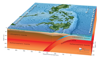
The geology of the Philippines is complex, with the majority of the islands located on the east of the Sunda Plate. To the east of this lies the Philippine Sea plate, which is being subducted beneath the Sunda Plate (a breakaway part of the Eurasian Plate); further east, in the Mariana Islands, the Pacific Plate is being subducted beneath the Philippine Sea Plate. This is not a smooth process, and the rocks of the tectonic plates frequently stick together before eventually being broken apart by the rising pressure, leading to Earthquakes in the process. Material from the subducting Philippine Plate is heated by the temperature of the Earth's interior, causing lighter minerals to melt and the resultant magma to rise through the overlying Sunda Plate, fueling the volcanoes of the Philippines.
 
 Subduction beneath the Philippines. Yves Descatoire/Singapore Earth Observatory.
 
Witness accounts of Earthquakes can help geologists to understand these events, and the structures that cause them. The international non-profit organisation Earthquake Report is interested in hearing from people who may have felt this event; if you felt this quake then you can report it to Earthquake Report here.
 
The approximate location of the 6 July 2017 Leyte Earthquake. USGS.
 
See also...
 
http://sciencythoughts.blogspot.co.uk/2017/05/magnitude-69-earthquake-off-south-coast.htmlhttp://sciencythoughts.blogspot.co.uk/2017/04/magnitude-53-earthquake-off-northeast.html
http://sciencythoughts.blogspot.co.uk/2017/04/student-killed-in-landslide-on-luzon.htmlhttp://sciencythoughts.blogspot.co.uk/2017/02/magnitude-65-earthquake-off-north-coast.html
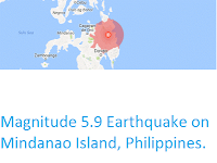
http://sciencythoughts.blogspot.co.uk/2017/01/landslide-kills-78-year-old-man-on-cebu.htmlhttp://sciencythoughts.blogspot.co.uk/2016/09/magnitude-59-earthquake-on-mindanao.html
Follow Sciency Thoughts on Facebook.

Saturday, 3 November 2012

Earthquake off Mindanao Island in the Philippines.

On Saturday 3 November 2012, slightly after 2.15 am local time (slightly after 6.15 pm on Friday 2 November, GMT) the The Philippine Institute of Volcanology and Seismology recorded a Magnitude 6.5 Earthquake at a depth of 78 km, off the northeast coast of Mindanao Island. No damage or casualties have been reported, but the United States Geological Survey, which measured the quake as a magnitude 6.1 event at a depth of 38.1 km, estimate that a quake on this scale in this area would have a 35% chance of leading to fatalities.

Map showing the area where the quake could be felt  (black circle) and where damage to buildings was likely (red circle). Geoscience Australia/Google Maps.

The geology of the central Philippines is Complex. The west of Mindanao Island is located on the Banda (or Sunda) Microplate, and the east on the Philippine Sea Plate, which is being subducted beneath the Sunda (or Banda) Microplate along the central part of the island. Immediately to the east of the Island the Pacific Plate is being subducted along the Philippine Trench, and passes beneath eastern Mindanao as it sinks into the Earth; this is the margin along which the 3 November quake took place.

Diagram showing the relationship between the Banda (or Sunda), Philippine Sea, and Pacific Plates beneath Mindanoa. Pubellier & Meresse (2012).

As the plates pass under one another they constantly stick together until the pressure from the westward movement of the Pacific Plate builds up sufficiently to force them to break apart and shift relative to one-another, causing Earthquakes. In addition, as the plates sink beneath each-other, they are heated by the friction and the heat of the planet's interior, causing them to partially melt. Some of the melted material then rises through the overlying plates, fueling volcanism.


Follow Sciency Thoughts on Facebook.

Thursday, 20 September 2012

Eruption on Gamalama.

Gamalama is a largely submerged volcano to the west of Halmahera in Indonesia. It's tip forms the island of Ternate, home to 145 000 people, and formerly the home of the Sultanate of Ternate, which at its height ruled much of what is now eastern Indonesia and the southern part of the Philippines. The island covers 76 km², and the summit of the volcano rises 1715 m above the sea. Gamalama is an active volcano, typically erupting several times a decade, it's last eruptive episode, in December 2011-January 2012, killed at least three people and produced a number of destructive lahars (mudflows triggered by volcanic activity) which destroyed several villages.

A lahar sweeps through a village on Ternate. Pusat Penanggulangan Krisis Kesehatan.

For the first two weeks of September 2012 the summit of Gamalama was obscured by cloud and fog, although what appeared to be a small plume could frequently be seen over the volcano. Then on the evening of 15 September an explosive eruption lead to ashfalls in the capitol (also Ternate). The next day rumbling was audible from the volcano, before a second eruption at about 2.15 pm, which produces a plume roughly 1 km high which drifted to the south and southeast, producing further ashfalls. The alert status on the island remains high, with people recommended to avoid going within 2.5 km of the summit.

Aerial photograph of a plume over Gamalama taken on Sunday 16 September 2012. Jakarta Post.

Halamahera and Ternate lie on the eastern edge of the Molluca Sea, which is underlain by the Molluca Sea Plate, a remnant plate being subducted from both sides. In the west the Molluca Sea Plate is being subducted beneath the Sangihe Plate, which underlies the northern part of Sulawesi, to the east it is being subducted beneath the Philippine Sea Plate, which underlies Halamahera and its surrounding islands. As it is subducted the Molluca Sea Plate is heated by friction with the overlying Sangihe and Philippine Sea Plates, and by the heat of the Earth's interior. Some of the melted material rises through the overlying plates, fueling the volcanoes of Halamahera and Sulawesi.

Map showing the location of Ternate at the eastern edge of the Molucca Sea. Google Maps.
Diagram showing the Molucca Sea Plate beneath the Molucca Sea. Hall & Wilson (2000).

See also Earthquake hits SulawesiEruptions from the Tompaluan Crater, Lokon-Empung, SulawesiVolcanic activity in the Halmahera Islands and Volcanoes on Sciency Thoughts YouTube.

Follow Sciency Thoughts on Facebook.

Friday, 31 August 2012

Massive Earthquake to the east of the Philippines.

On Friday 31 August 2012, slightly after 8.45 pm local time (slightly after 12.45 pm, GMT), the United States Geological Survey recorded an Earthquake roughly 100 km east of Samar Island in the Philippines as measuring 7.6 on the Richter Scale, at a depth of 34.9 km. This is an extremely large quake and is likely to cause considerable problems throughout the Philippines, and potentially neighbouring countries. No reports of any damage or casualties have emerged yet, but the USGS estimate such a quake in this location will have a 35% chance of causing at least one fatality. The NOAA Tsunami Centre issued a tsunami alert for the Philippines, Japan, Indonesia, Taiwan, Papua New Guinea, Hawaii,Guam, Yap and the Northern Mariana Islands, though this has now been lifted for some of these areas.

Map showing the areas that suffered the worst shaking. Areas within the greenish circle are likely to have suffered damage to buildings. USGS.

The geology of the Philippines is complex, with the majority of the islands located on the east of the Sunda Plate. To the east of this lies the Philippine Sea plate, which is being subducted beneath the Sunda Plate; further east, in the Mariana Islands, the Pacific  Plate is being subducted beneath the Philippine Sea Plate. 

The 31 August 2012 quake appears to have happened on the Philippine Trench, where the Philippine Sea Plate is being subducted beneath the Sunda Plate. Quakes on such margins are not uncommon, as tectonic plates do not sink smoothly past one-another, but rather stick then break apart. This presents a high risk of tsunami generation on subductive margins, as the overlying plate can stick to the underlying plate and be drawn back like a bow-string, until the pressure causes the rocks to rift sharply, and the plate margin snaps back suddenly.

Cartoon animation showing how a tsunami can be genrated on a subduction zone. EarthScope.

Follow Sciency Thoughts on Facebook.
 

Friday, 15 June 2012

Earthquake in eastern Taiwan.

About 15 minutes after midnight on Friday 15 June 2012, local time (4.15 pm on Thursday 14 June, GMT), an Earthquake struck eastern Taiwan. This was recorded by the United States Geological Survey as occurring at a depth of 5.9 km, 28 km to the south of the city of Hualien, and as measuring 5.2 on the Richter Scale. The quake was apparently felt across much of the island, but there are no reports of any damage or casualties; Taiwan is an extremely Earthquake prone country, and consequently well prepared for such events.

Map showing the location of the 15 June Earthquake. USGS.

Taiwan lies on the boundary between the Eurasian and Philippine Sea tectonic plates. This is a somewhat complex affair, with the two plates subducting beneath one-anther on different parts of the island. From the center of the island to the south coast, and onwards towards the Philippines, the Eurasian Plate is subducting beneath the Philippine Sea Plate. From the center of the island to the east coast and on towards Japan the Philippine Sea Plate is being subducted beneath the Eurasian Plate. This  tectonic folding places a great deal of stress on the rocks of the island, making it extremely Earthquake-prone.

Rough diagram of the tectonic margins beneath Taiwan. Angelier (1986).

See also Japan shaken by pair of major EarthquakesEarthquake shakes south TaiwanMapping the subductioin zone beneath TaiwanMassive Earthquake shakes Cebu & Negros Islands in the Philippines and Earthquakes on Sciency Thoughts YouTube.

Follow Sciency Thoughts on Facebook.

Sunday, 26 February 2012

Earthquake shakes south Taiwan.

Slightly before 10.35 am local time (slightly before 2.35 am GMT) on Sunday 26 December 2012, an Earthquake measured as 5.9 on the Richter Scale at a depth of 22.4 km by the United States Geological Survey struck a mountainous region of southern Taiwan, causing shaking that was felt across much of the island. The shaking was apparently particularly severe in the southern city of Kaohsiung, where it caused buildings to sway severely for about 7 seconds, leading to widespread panic, though their does not appear to have been any significant damage or casualties.

Map of southern Taiwan, showing the epicenter of the quake, and the areas most severely shaken. United States Geological Survey.

Taiwan lies on the borders of two tectonic plates, the Philippine Sea Plate and the Eurasian Plate. The relationship between the two is quite complex, with the Eurasian plate being subducted under the Philippine Sea Plate in the south of the island, and along the Luzon trench, which extends south from the island to the Philippines, and the Philippine Sea Plate being subducted under the Eurasian Plate in the north of the Island, and along the Ryuku Trench which extends northeast from the island to Japan.

This leads to a large number of quakes on the island, though most do not do serious damage. The worst quake in recent times was in 1999, when an Earthquake in the center of the island killed over 2300 people.

Sunday, 19 February 2012

Mapping the subductioin zone beneath Taiwan.

The island of Taiwan (Formosa) sits on the boundary between two tectonic plates the Eurasian and the Philippine Sea. To the south of the Island the Manila Trench, in which the Eurasian Plate is being subducted beneath the Philippine Sea Plate, extends southward to the Philippines. To the east the Ryuku Trench, in which the Philippine Sea Plate is being subducted beneath the Eurasian, extends northeast to Japan. Taiwan forms part of two island-arcs, the Ryukyu Arc, which is formed volcanically from material which is subducted in the Ryuku Trench, melted by the heat of the Earth's interior, then rises through the overlying Eurasian plate to form volcanic islands, and the Luzon Arc on which melted material from the subducting Eurasian Plate is rising through the overlying Philippine Sea Plate.

In a forthcoming paper in the journal Tectonophysics, a team of scientists lead by Kamil Ustaszewski of the Lithosphere Dynamics Section at the Helmholtz Centre Potsdam German Research Centre for Geosciences describe how they built up a map of the geological structure underneath Taiwan, using Earthquake tomography, a technique that uses vibrational waves created by natural earthquakes (of which there are quite a lot in Taiwan) to create a three dimensional picture in the same way that a sonar uses artificially generated sound waves.

Three dimensional map of the structure beneath Taiwan; the Moho is the Mohorovičić Discontinuity, which forms the boundary between the Crust and the Upper Mantle. Scale bar is in kilometers. From Ustaszewski et al. (2012).

This revealed that the Eurasian Plate is folded sharply beneath the Island along a north-south line bisecting the island and sinking into the Earth at close to 90°. The Philippine Sea Plate is moving past this, being pushed northwards by an extension centre (ocean ridge) to the south. Towards the north end of the island the Philippine Sea Plate is itself being subducted, at a less steep angle, beneath an accretionary prism made up of material that is not easily subducted, such as old volcanic islands that have been dragged along by the moving plate. This prism has become annealed to the Eurasian plate, forming an new section of continental lithosphere, complete with an emerging Mohorovičić Discontinuity, the upper part of this being covered by sediment, is indistinguishable from the older Eurasian crust, leading to the illusion of two tectonic plates being subducted beneath one-another in the same place.

Tuesday, 7 February 2012

Massive Earthquake shakes Cebu & Negros Islands in the Philippines.

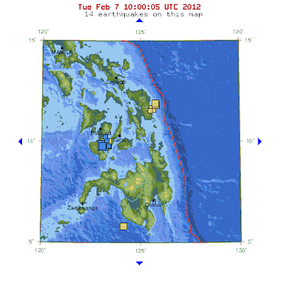
Slightly before 11.50 am, local time (slightly before 3.50 am, GMT), on Monday 6 February 2012, the Philippine Islands of Cebu and Negros were shaken by an Earthquake measured by the United States Geological Survey as a 6.7 on the Richter Scale at a depth of 20 km, midway between the islands. Local press have widely reported this as a magnitude 6.9 quake, which may come from the Philippine Institute of Volcanology and Seismology, though their website is down at the time of writing, making this hard to check. The quake has been followed by a number of severe aftershocks, one at 6.10 pm, local time (10.10 am, GMT), measuring 6.0 on the Richter Scale according to the United States Geological Survey.

Map showing the location of the quakes, cluster of blue squares. The first quake is the yellow square behind the blue squares, other yellow squares represent other quakes within the last week. The red line is the Philippine Trench, where the Philippine Sea Plate to the east is being subducted beneath the Philippine Mobile Belt, on which most of the Philippine Islands sit. From the United States Geological Survey.

At the time of writing the official death toll from the quake is 15, with unofficial sources giving numbers as high as 52. Official figures also give 71 missing, 52 hospitalized and many hundreds more injured. The majority of the deaths are likely to have been caused by landslides, though there is apparently also widespread damage to buildings and bridges. The full extent of the destruction will probably not be known for several days. At the time of the initial quake there was widespread fear that it would be followed by a dangerous tsunami, but this did not occur.


Sudden inrush of water in Cebu, following the quake; technically this is a tsunami, but not life-threatening. Irene Nipaya, Balamban, Cebu.

The geology of the Philippines is complex, with the Philippine Sea Plate to the east and the Sunda Plate to the west both being subducted beneath the Philippine Mobile Belt, on which most of the islands sit. The Mobile Belt is slowly being pulled in several different directions by this, and geologists have mapped hundreds of faults in the islands - often by measuring quakes. On this occasion the quake may have revealed a previously unknown fault, according to Ishmael Narag of the Philippine Institute of Volcanology and Seismology's Seismological Observation and Earthquake Prediction Division.

Map of the Philippines showing Subductive Margins (Trenches) and known faults. From the Philippine Institute of Volcanology and Seismology.

Saturday, 28 January 2012

Earthquake shakes Yamanashi Prefecture, Japan.

Slightly before 7.45 am on 28 January 2012 local time (slightly before 10.45 pm on 27 January, GMT) an Earthquake shook the Yamanashi Prefecture in Japan, and was felt in surrounding areas. The quake was recorded as measuring 5.5 on the Richter Scale by the Japan Meteorological Agency, and as occurring at a depth of about 20 km. The quake was followed after a few minutes by an aftershock measuring 4.1 on the Richter Scale, also at a depth of 20 km. There are no immediate reports of any casualties or serious damage.

Map of the effected area from the Japan Meteorological Agency (red cross). The colours refer to the intensity of shaking, higher numbers indicate more severe shaking.

Japan lies on the boundary between four tectonic plates, the Eurasian, Philippine Sea, Pacific and North American. Yamanashi Prefecture is in the Yatsugatake Mountains, which lie over the border between the Eurasian and Philippine Sea Plates. The Philippine Sea Plate is being subducted beneath the Eurasian Plate in the Nankai Trench to the south of Honshu Island. As it passes under the island it sticks to the underside of the Eurasian Plate, causing the overlying plate to crumple, and forming fold mountains. This causes periodic build ups of pressure, which are released in Earthquakes. In addition as the Philippine Sea Plate sinks into the Earth, it is melted by the heat of the planet's interior. When this happens some of the melted rock rises up through the overlying Eurasian Plate, leading to the formation of volcanoes in the Yatsugatake Mountains.

Map of Japan showing the plate boundaries. The Yatsugatake Mountains are part of the SW Japan Arc.

Friday, 20 January 2012

Explosion on Suwanosejima.

Suwanosejima is a volcanic island in the Tokara Archipelago, part of the Ryukyu Islands, a volcanic arc that run southward from the southeastern tip of Kyushu towards Taiwan. The island is essentially a single giant stratovolcano, with four craters arranged in a line from the centre of the island, nine kilometers southwest to within a kilometer of the sea. The northeasternmost of these craters is the highest, at 799 m, and the most active, though there are occasional eruptions from the other craters. The island is about 200 km south of Kagoshima, mainland Japan's most southerly city, and has a population of about 50, including a commune run by the Buzuko counter-culture group.

Simplified map of Suwanosejima. From the Smithsonian Global Volcanism Program.

An explosion was reported in the O-take crater on 12 January 2012, by the Tokyo Volcanic Ash Advisory Centre, though no further activity has been reported. The Japan Meteorological Agency has issued a Level 2 warning for the volcano, recommending that people do not approach the crater. The volcano is one of Japan's most active, and has caused the island to be abandoned on a number of occasions.

Map from the Japan Meteorological Agency, showing the location of Suwanosejima (bottom of the map). The large island in the top half of the map is Kyushu.

The volcano most recently erupted in October 2011, when an ash plume was seen rising 1.2 km above the island. Plumes were also reported above the island in January, February, April, July and September 2011, and explosions heard from the crater in January, February, March, April, May and September. This is a part of an ongoing eruptive cycle than began in December 2000, with the emergence of two small subsidiary craters within the main O-take crater, and a series of Earthquakes in 2001-02.

Photograph of an eruption from O-take crater on Suwanosejima taken from a helicopter on 12 May 2001. From the Japan Meteorological Agency.

Prior to this Suwanosejima had been quiet since 1996, when a cycle of eruptions that began in 1949 ended. Prior to this the island had seen major eruptions in 1884-85, when lava reached the East coast, and 1813-14, when lava from the Southwest crater reached the West coast, the Northeast (O-take) crater collapsed in an avalanche that reached the East coast, most of the island was covered in ash and tephra, and the island was abandoned for 70 years. The Island was also abandoned for several centuries after an eruption in the fifteenth century, and archaeological evidence suggests this has happened several more times in the last few thousand years.

The island is part of the Ryukyu Island Arc, which sits on top of the boundary between the Eurasian and Philippine Sea Plates. The Philippine Sea Plate is being subducted beneath the Eurasian Plate, in the Ryukyo Trench, to the Southeast of the Islands. As it is drawn into the interior of the Earth, the tectonic plate is partially melted by the heat of the Earth's interior, and liquid magma rises up through the overlying Eurasian Plate to form the volcanos of the Ryukyu Islands and Kyushu.

Simplified section through the Ryukyu Islands.

There are nine other volcanoes in the Ryukyu Ilsands, and nine more on Kyushu which lie on the same subduction zone.

Iriomotejima is a submarine volcano at the southern end of the Ryukyu Islands, 25 km to the north of Iriomotejima Ilsand. It last erupted in 1924, but occasionally has bouts of Earthquake activity, most recently in 1992-3.

Iwo-tori-shima (or Okinawa-tori-shima) is a twin volcano to the north of Okinawa. It comprises two islands derived from a single volcano. Tori-Jima (which means Bird Island, and is a common name for offshore islands in Japan) is to the southeast and comprises a pair of concentric craters with a lava dome in the middle. Iwo-dake has a small lake, and sulphur deposits that have been worked commercially in the past. The last eruption was a small explosion on 18 July 1968.

Yokoatajima is a volcanic island with two summits, Higashimine to the east and Nishimine to the west. The island may be part of a larger, submerged, caldera. The most recent possible (i.e. unconfirmed) eruption was in 1835.

Akusekijima is a stratovolcano in the southern Ryukus, rising 584 m above the sea. It probably has not erupted for about 80 000 years.

Nakanoshima is a stratovolcano in the Tokara Islands, about 30 km north of Suwanosejima. The last (small) eruption was in 1914, though a cloud of smoke was reported over the island in 1949. The island was mined for sulphur until 1944.

Kogajiima is a small volcanic island to northwest of Nakanoshima. It is not thought to have erupted since the Pleistocene.

Kuchinoshima is a larger island north of Nakanoshima. It comprises two stratovolcanoes and a string of lava-domes. The last eruption on Kuchinoshima is thought to have taken place in about 1190 AD.

Kuchineorabujoma is another larger island north of Nakanoshima. It has three summits along a north-south line, Furutake to the south, Shintake (the youngest) in the middle and Nioke (the oldest) to the north. All historical eruptions have been from Shintake, the most recent in March 2009; the last major eruption was in 1933.

Satellite image of Kuchineorabujoma, from Google Earth.

Kikai is a largely submerged caldera at the northern end of the Ryukyu chain. It was the source of a major eruption about 6300 years ago (before which it was probably not submerged) that saw pyroclastic flows (avalanches of hot gas and ash) reach across the sea to Kyushu, 100 km away, and ash-falls as far away as Hokkaido. The eruption devastated Kyushu, remained uninhabited for centuries. The caldera is still active, having last erupted in 2004.

The Ibusuki Volcanic Field is at the southern tip of Kyushu. The only active volcano in the field is Kaimondake, which last erupted in 1615, and last had a major eruption in about 885 AD.

View of Kaimondake.

Sakurujima is a highly active volcano at the northern end of Kagoshima Bay. It is formed on the older Aira Caldera which was active till about 22 000 years ago. Sakurujima has been active for about 13 000 years, with recorded eruptions since the eighth century, the largest of which took place in 1471-76. The volcano is still active, with an ash plume recorded on 14 January 2012.

Sumiyoshiike and Yonemaru are maars (craters without summits) north of the Aira Caldera, and possibly associated with it. Both have were formed about 8000 years ago, but have been inactive since.

Kirishima is a shield volcano north of Kagoshima Bay. It has about 20 summits, of which Karakunidake is the highest, at about 1700 m. The volcanic complex produces frequent small eruptions, the most recent of which was in August 2011.

Eruption on Kirishima, 26 January 2011.

Fukuejima is a cluster of shield volcanoes forming an island off the west coast of Kyushu. They were active from about 900 000 years ago until about 2000 years ago, and is still monitored by the Japan Meteorological Agency, who consider there is a risk of future eruptions.

Unzen is a volcanic complex on the Shimabara Peninsula, east of Nagasaki. In 1792 a pyroclastic flow in the Unzen field caused a devastating tsunami. The most recent eruption was in 1996, when a partial dome collapse caused another pyroclastic flow.

The Aso Caldera is in central Kyushu. It is 24 km wide and was the source of four major eruptions between 300 000 and 90 000 years ago, which covered the island in pyroclastic flows. Since then 17 smaller volcanoes have grown up inside the caldera. One of these, Nakadake, remains extremely active, having last erupted in June 2011.

View of Nakadake, foreground, smoking, with Ohachi (right), Takachihonomine (centre & highest) and Futasuishi (left) in the background. From the Smithsonian Volcano Program.

The Kuju complex lies to the northeast of Aso, and comprises a complex of 16 lava domes and 6 volcanic cones. The complex has been active for about 150 000 years; the last eruption was in 1996, with a series of Earthquakes in 1997.

The Tsurumi Lava Dome Complex lies above the thermal spring resort of Beppu, on the northeast coast of Kyushu. It comprises two large lava domes, Tsurumi and Yufu, and three smaller ones. The domes are less than 6300 years old, with the most recent eruption taking place in 847 AD.