Wednesday, 10 October 2012

Earthquake under the English Channel.

On Monday 8 August 2012, slightly after 4.10 am, British Summertime (slightly after 3.10 am, GMT), the British Geological Survey recorded a Magnitude 2.2 Earthquake 7 km beneath the English Channel, roughly 30 km northwest of Guernsey. An Earthquake this small and this far offshore is highly unlikely to have been felt, much less to have caused any damage or casualties.

Map showing the location of the 8 August Earthquake. Google Maps.

The cause of quakes in the Channel area is not always immediately obvious. Events at the seabed surface are most likely to be submarine landslips, but this event is far too deep for this to be a possibility. The Channel is on the Eurasian Plate, and is being pushed to the east by the expansion of the Atlantic Ocean and to the north by the impact of Africa into Europe from the south, though neither of these are immediate causes of stress. Closer to the Channel there are lesser areas of extension beneath the North Sea, the Rhine Valley and the Bay of Biscay, all of which excerpt tectonic stress on the Channel area to some extent. Finally there is glacial uplift; much of Europe was covered by a thick layer of glacial ice until about 10 000 years ago, including most of the north of the UK, and upland areas of France, such as the Alps and the Pyrenees. This ice pushed the rocks of the lithosphere down into the underlying mantle, and now that it is gone these rocks are springing back up, albeit at geological speeds, causing the occasional Earthquake in the process.

Witness accounts are a valuable resource for scientists trying to understand Earthquakes and the rock processes that cause them. If you felt this quake (or if you were in the area but did not feel the quake, which is also useful information) you can report it to the BGS here.


Follow Sciency Thoughts on Facebook.

Earthquake near Dumfries, southwest Scotland.

On Saturday 6 October 2012 at 1.30 pm, British Summertime (12.30 pm, GMT), the British Geological Survey recorded a Magnitude 1.1 Earthquake 2 km beneath the Scottish village of Johnstonebridge, roughly 20 km northeast of Dumfries, or 40 km northwest of Carlisle. Earthquakes of this magnitude are highly unlikely to cause any damage or casualties, and quite often go unnoticed by the local population, as seems to have been the case with this event.

The location of the 6 October 2012 Earthquake. Google Maps.

The UK is not noted for its Earthquake activity, but small quakes of this kind are not uncommon, and tend to become more frequent as you move north and west, making the west of Scotland the most quake-prone part of the country.

There is no single cause to which Scottish Earthquakes can easily be attributed, but rather the country is subject to tectonic stresses from a variety of sources, with most quakes being the result of tectonic stresses from a variety of sources. Scotland, along with the rest of Eurasia, is being pushed to the east by the expansion of the Atlantic Ocean and to the north by the impact of Africa into Europe from the south. There are also lesser areas of tectonic spreading beneath the Rhine Valley, the North Sea and the Bay of Biscay, all of which will excerpt stress upon British rocks. In addition there is glacial rebound; until about 10 000 years ago much of northern Europe, including most of Scotland, was covered by a thick layer of glacial ice, which pushed the rocks of the Scottish lithosphere down into the underlying mantle. This ice is now gone, and the rocks are still slowly rebounding, causing the occasional Earthquake in the process.

Witness statements can help geologists to understand the movements during Earthquakes and therefore the structures that cause them. If you felt this quake (or if you were in the area but did not, which is also useful information), then you can report it to the British Geological Survey here. 


Follow Sciency Thoughts on Facebook.

Sunday, 7 October 2012

A new species of Cichlid Fish from Lake Tanganyika.

Cichlid fish of the genus Lepidiolamprologus are restricted to Lake Tanganyika in east Africa. There are at least six species, and possibly over ten, though taxonomists differ about classification schemes for the genus.

In a paper published in the journal Zootaxa on 20 September 2012, Sven Kullander of the Department of Vertebrate Zoology at the Swedish Museum of Natural History and  Magnus and Mikael Karlsson, of African Diving Ltd. in Dar es Salaam propose a new species of fish in the genus, from the waters around Kamamba Island near the east shore of the lake.

Kamamba Island. Kullender et al. (2012).

The new Fish is named Lepidiolamprologus kamambae, meaning from Kamamba. It is a 118-135 mm mottled brown fish, with a protruding lower jaw, known only from male specimens.

Lepidiolamprologus kamambae in the wild. Kullender et al. (2012).

Map showing the distribution of Lepidiolamprologus kamambae, and closely related species within the same genus (top). Members of the genus Lepidiolamprologus (bottom). (A) L. kamambae. (B) L. kendalli. (C) L. elongatus. (D) L. profundicola. Kullender et al. (2012).

See also A new species of Cichlid Fish from Lake MalaĆ”i, Two new species of Sandperch from the South China Sea, A new species of Toothcarp from Iran, New species of Grenadier from Japan and Boney Fish on Sciency Thoughts YouTube.

Follow Sciency Thoughts on Facebook.

Thursday, 4 October 2012

Two new species of Ant from northwest India.

Ants of the genus Tetramorium are one of the most successful and and numerous groups of Ants, with nearly 500 species described globally. They are at their most abundant in tropical Africa, where there are at least 230 described species, but are common throughout the Old World. Only 13 species have been described from the Americas. The common European Pavement Ant (Tetramorium caespitum) is a member of the genus.

In a paper published in the journal ZooKeys on 11 July 2012, Himender Bharti and Rakesh Kumar of the Department of Zoology & Environmental Sciences at Punjabi University announce the discovery of two new species within the genus Tetramorium from India, and in addition the discovery of three species in northwest India not previously recorded within that part of the country.

The first new species described is named Tetramorium shivalikense, after the Shivalik Mountains where the Ants were discovered. The Ants were found in Himachal Pradesh, Punjab and Uttarakhand States, living in soil and leaf litter. The species is described on the basis of 101 worker Ants, found at altitudes of between 420 and 1140 m. Neither the queen nor the male Ants were discovered.

Worker of Tetramorium shivalikense in lateral view. Bharti & Kumar (2012).

The second new species described is named Tetramorium triangulatum, a name which refers to the triangular propodeal spines (spines on the back of the thorax) of the Ants. This species is also from the Shivalik Mountains, and was collected from soil samples in Himachal Pradesh, Punjab and Uttarakhand States, at altitudes of between 250 and 940 m. The species is described from 48 workers, 25 queens and 32 male Ants.

Tetramorium triangulatum worker (top), male (middle) and queen (bottom). Bharti & Kumar (2012).

The first species described from northwest India for the first time is Tetramorium caldarium, a tramp species (species spread widely around the world by human behavior) previously known from Germany, Kenya, the Democratic Republic of Congo, Norfolk Island, Rajastan, Jaipur, Mauritius, Madeira, Cape Verde, Great Britain, New Caledonia, Egypt, Sudan, Ivory Coast, Nigeria, St Helena, USA, Mexico, Puerto Rica, Haiti, Dominican Republic, Columbia, Brazil and Peru. The species is reported in Punjab State from a single worker Ant found on disturbed ground in Patiala.

Tetramorium caldarium worker. Bharti & Kumar (2012).

The second species found in the area for the first time is Tetramorium tonganum, which was found to be fairly widespread in the Shivalik Mountains, being collected from a number of sites in Himachal Pradesh and Uttarakhand. Worker, queen and male ants were all discovered, and the male of the species described for the first time. The species has previously been described from Tonga, Sri Lanka, Malaysia, Japan, The Philippines and a number of Pacific islands.

 Tetramorium tonganum worker (top), queen (middle) and male (bottom). Bharti & Kumar (2012).

The final species recorded is Tetramorium urbanii, previously described from Bhutan and now described in India for the first time, from two workers found in Shillong in Meghalaya State in the northwest of India.

Tetramorium urbanii worker. Bharti & Kumar (2012).

See also Ants in the diet of a Cambodian Pitcher Plant, New species of Ghost Ant named after Edward O. Wilson and Evidence of fungal parasites modifying the behavior of ants from the Eocene Messel Shale.

Follow Sciency Thoughts on Facebook.

Eruption on Mount Marapi, Sumatra.

Mount Marapi in, western Sumatra, is generally considered to be the island's most active volcano. It rises 2891 m above the sea, and has a broad summit with numerous, overlapping, craters inside a 1.4 km caldera. There have been over 50 eruptions since 1900, often with more than one in a year, though these generally only comprise small explosions and volcanic plumes; no lava flow outside the caldera has been recorded in historic times. Despite this the volcano can be dangerous, an unexpected eruption in 1992 killed a climber and injured a number of tourists.

A tourist inspecting a small eruption on Mount Marapi in August 2011. The localized nature of these events has occasionally lead people to become over-confident around them, leading to fatalities. Johann Angerler/Picasa.

The volcano produced a 600 m plume in May 2012, then was quiet until August, when it began to produce thick ash and smoke. By Tuesday 18 September this was reaching 200 m above the summit, although this was often hidden by mist and cloud. On 26 September this eruptive activity increased sharply, throwing up an ash plume that rose 1.5 km above the summit; the first plume of Marapi to exceed 1 km since August 2011. The alert level on the volcano remains high, but there are no plans for an evacuation since there are no permanent settlements inside what is considered to be the volcano's danger zone.

Maps showing the topography of Mount Marapi (top) and its location on Sumatra (bottom). Google Maps.

Sumatra lies on the Sunda Plate, immediately to the east of the Sunda Trench, along which the Indian Plate is being subducted. The subducting plate passes under Sumatra as it sinks into the Earth, leading to Earthquakes and volcanism. The quakes are caused by the plates (which are not smooth) constantly sticking together and then breaking apart as the pressure builds up. Volcanism is caused by the partial melting of the Indian Plate, due to the friction, pressure, and the heat of the Earth's interior. This leads to the formation of liquid magma, which then rises through the overlying Sunda Plate, feeding the volcanoes of Sumatra.

Diagrammatic representation of the subduction of the Indian Plate beneath Sumatra. Virtual Upper Mantle of the Earth.


Follow Sciency Thoughts on Facebook.

Wednesday, 3 October 2012

A Tyrannosaurid metatarsal from the 'El Gallo' Formation of Baja California, México.

Tyrannosaurids were large, predatory Dinosaurs from the Late Cretaceous of North America and Eurasia. They are among the best known of all Dinosaurs, since they were the biggest carnivores in their ecosystems, making them (particularly the eponymous Tyrannosaurus rex at 13 m and up to 6.8 tonnes) a must have for any Hollywood movie featuring Dinosaurs. The group has been extensively studied, with a fairly large number of well preserved specimens known, making it possible to assign fragmentary remains and even individual bones to the group with some confidence.

Movie depictions of Tyrannosaurids like this one have made them one of the best known (and best loved) groups of Dinosaurs. King Kong/Peter Jackson/Universal Pictures.

In a paper published in the journal Acta Palaeontologica Polonica on 22 August 2012, a team of scientists led by Brandon Peecook of the Department of Biology and Burke Museum of Natural History and Culture at the University of Washington discus the discovery of a metatarsal (foot bone) of a Tyrannosaurid Dinosaur in the Late Cretaceous 'El Gallo' Formation of Baja California.

The left fourth metatarsal (red) on a human. Modified from The Florida Center for Instructional Technology.

The specimen is a left fourth metatarsal 391 mm in length. It has a deep notch on its articular surface and a concave posterior surface, features that were used to diagnose the bone as having come from a Tyrannosaur. This is not, however, enough information to make any more specific diagnosis, though the bone is small for a Tyrannosaur metatarsal, suggesting it may have come from a juvenile animal.

The 'El Gallo' Tyrannosaurid metatarsal. Peecook et al. (2012).

The bone comes from the El Disecado Member of the ‘El Gallo’ Formation, making it between 75.21 and 74.55 million years old (the 'El Gallo' Formation is placed in inverted commas because the name is not official, it derives from an unpublished Ph.D dissertation from 1963, and has entered popular usage, but the formation has never been formally described). 

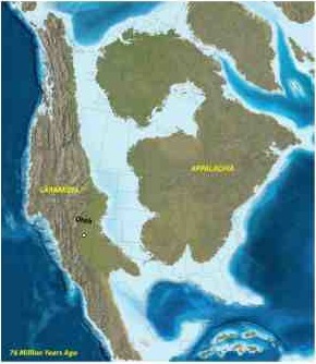
This is the first Tyrannosaurid described from Baja California. During the Cretaceous North America was divided in two by a vast inland sea, the Western Interior Seaway. The landmass to the east of this is called Appalachia, that from the west (of which Baja California forms a part) is called Laramidia. Tyrannosaurs are known from Laramidia, but only from the east and northeast of the island. Baja California, on the southern Pacific Coast of Laramidia, therefore represents an extension of the known range of Tyranosaurid Dinosaurs.

Map of North America during the Late Cretaceous. US Bureau of Land Management.


Follow Sciency Thoughts on Facebook.

Monday, 1 October 2012

Comet C/2012 S1 (ISON) to pass within 60 000 000 km of the Earth.

Comet 2012/S1 (ISON) was discovered by Vitali Nevski and Artyom Novichonok at the International Scientific Optical Network near Kislovodsk, Russia on 21 September, and its discovery rapidly confirmed by follow-up observations from the Remanzacco Observatory in Italy, and detection of the (previously unnoticed) comet in images from other telescopes dating back as far as December 2011. 

Photograph of 2012/S1 (ISON). RAS Observatory.

The comet is currently approaching the Inner Solar System on a parabolic orbit that suggests that it might have recently been disturbed from an orbit which kept it entirely within the Oort Cloud. If this is the case, and 2012/S1 (ISON) has not previouly visited the Inner Solar System, then the commet is likely to produce a substantial icy tail (each time a comet visits comes close to the Sun then some of its ice is lost, so that 'fresher' comets that have not made to many visits, will have more ice to shed), and consequently appear brighter to observers.

2012/S1 (ISON) will pass within 0.07 AU of Mars on 1 October 2013 (0.07 Au = 7% of the distance between the Earth and the Sun, or about 10 000 000 km). It will reach its perihelion (closest point to the Sun) on 28 November, coming within 0.00735 AU (1 100 000 km) of the surface of the Sun, and pass by the Earth on 26 December 2012, at a distance of 0.4 AU (60 000 000 km).

The position of Comet 2012/S1 (ISON) on 1 October 2012, and it's orbit relative to the plane of the Solar System. NASA/JPL Small-Body Database Browser.

It has been widely reported that 2012/S1 may outshine the full Moon when at its closest to the Sun, though predictions about the brightness of comets should be made with caution, and it may be difficult to see the comet when it is this close to the Sun. It is quite likely it will be easier to observe as it passes the Earth, even if it is not as bright in the sky.

See also The Perseid Meteors, Asteroid 2002 AM₃₁ flies past the Earth, 2012 LZ1; bigger than we thought, Asteroid 2012 LZ1 flies by the Earth and The origin of Comet P/2006 VW₁₃₉.

Follow Sciency Thoughts on Facebook.