Tuesday, 5 May 2015

Groundwater systems beneath the McMurdo Dry Valleys of Antarctica.


The McMurdo Dry Valleys are a largely ice-free region of Antarctica on the Ross Sea coast, discovered by Robert Scott in the early twentieth century. The valleys contain a series of lakes, lacking surface connections and often separated by glaciers. Most of the ground in the valleys is frozen, though near-surface groundwater seeps and tracks are present in the upper 70 cm of soil, which are typically extremely saline, enabling them to remain liquid at temperatures below zero degrees centigrade. Deeper saline waterways are also predicted in the Valleys, but several attempts at finding them with boreholes by the Antarctic Dry Valley Drilling Project in the 1970s were unsuccessful.

The most famous feature of the Valleys is Blood Falls, an intermittent outpouring of highly saline, iron-rich water from Taylor Glacier into Lake Bonney, which stains the surface of the glacier a deep crimson. This is thought to be caused to by the weight of the glacier pressing down on deepsubsurface waters and forcing them to migrate upwards. The waters of Blood Falls are known to host a rich microbial community, which probably help to weather iron from the bedrock metabolically. The water of blood falls is sufficiently saline to remain a liquid a -6˚C at surface pressures, and therefore at cooler temperatures in the higher pressure conditions beneath the glacier.

Blood Falls, McMurdo Dry Valleys, Antarctica. Peter Rejcek/National Science Foundation/Wikipedia.

In a paper published in the journal Nature Communications on 28 April 2015, Jill Mikucki of the Department of Microbiology at the University ofTennessee, Knoxville, Esben Auken of the Department of Geosciences at AarhusUniversity, Slawek Tulaczyk of the Department of Earth and Planetary Sciences at the University of California, Santa Cruz, Ross Virginia of the Environmental StudiesProgram at Dartmouth College, Cyril Schamper of Sorbonne Universités, Kurt Sørensen, also of the Department of Geosciences at Aarhus University, Peter Doran of the Departmentof Geology and Geophysics at Louisiana State University, Hilary Dugan of the Departmentof Earth and Environmental Sciences at the University of Illinois at Chicago and Neil Foley, also of the Department of Earth and Planetary Sciences at the University of California, Santa Cruz describe the results of a study of deep groundwater in the McMurdo Dry Valleys using airborne electromagnetic systems to measure the resistivity of deep sediment layers.

Mikuckiet al. used a system called SkyTEM, which uses a high-powered transmitter loop carried by helicopter to induce subsurface electromagnetic currants. Similar systems have previously been used to map permafrost and buried ice features in the Alaskan Arctic and on Livingstone Island off the coast of Anartica.

Map of Taylor Valley in Antarctica. (a) Map of major lakes, glaciers and Antarctic Dry Valley Drilling Project (DVDP) boreholes in Taylor Valley, Antarctica. Dotted red line indicates the location of the Lake Fryxell DVDP geophysical survey. (b) Airborne electromagnetic flight lines in green with survey lines for which data were processed shown in yellow. Terrain surveyed in this paper is highlighted in red. Dashed line indicates regions where higher-resolution surveys were conducted in the Bonney and Fryxell Basins. Red circle indicates the location of the example SkyTEM sounding. Mikucki et al.(2015).

Mikucki et al. were able to differentiate buried brine systems, which have very low resistivities, in the order of 10–100 Ωm, from buried ice, which has a very high resistivity, in the order of 500–20,000Ωm. This enabled them to detect two extensive brine systems in the McMurdo Dry Valleys, one beneath Taylor Glacier and the upper Lake Bonney Basin and one beneath Lower Taylor Valley and the Lake Fryxell Basin.

Resistivity cross-section for the length of the Taylor Valley. Resistivity profile along the length of the Taylor Valley. Low resistivities near McMurdo Sound to Lake Hoare interpreted as hydrological connectivity of brine in sediments extending from the coastal margin inland and beneath the Canada Glacier. To the west, resistivities increase below Suess Glacier and again towards Lake Bonney. In the Bonney Basin, low-resistivity patterns suggest connectivity of brine-rich sediments below the Taylor Glacier with proglacial Lake Bonney at the glacier terminus and near the location of Blood Falls. Mikucki et al.(2015).

The McMurdo Dry Valleys are thought to have formed as a fjord system in the Miocene, when a wetter climate led to a more extensive Taylor Glacier (glaciers are ultimately formed from snowfall, so a warmer wetter climate will often produce a more extensive glacier than a cooler dryer one, as long as temperatures at the glacier itself remain below freezing point for most of the time) which extended during cooler periods and was intruded by seawater in warmer spells. During this cycle seawater would have become trapped in the valleys then turned to dense brines through cryoconcentation, a process in which the majority of the water freezes but the dissolved salt, which does not freeze, is concentrated in the remaining liquid. This would have led to a build-up of salts in the sediments beneath the valleys.

In the 1980s it was theorized that during the Pleistocene glacial episodes much of the McMurdo Dry Valleys would have been occupied by a glacial lake (lake trapped behind a glacier), Lake Washburn. However more recent studies have suggested that this may only have occupied the western part of the Valleys, with the lower eastern part alternatively occupied by a raised and intruding Ross Ice Shelf (sea ice floating on water) and a series of smaller glacial lakes. The repeated forming of such lakes from trapped seawater would have served to further raise the salinity of sediments in the lower Valleys by cryoconcentation.

Prior to this study the lakes of the McMurdo Dry Valleys were assumed to all be separate bodies, however Mikuckiet al.’s results suggest that the lakes of the lower Valleys are in fact connected by an extensive subsurface brine system which enables movement of water from one lake to another down the Valleys, beneath the separating glaciers.

Conceptual diagram depicting predicted hydrological connectivity. Two distinct regions of subsurface brine were identified in the MDV. The ‘?’ indicates the zone between Lake Bonney and Lake Hoare where no connectivity was identified with the survey. Mikucki et al. (2015).

The waters of Lake Hoare are known to be less saline than those of the other lakes in the Valleys. Previous studies of the system have postulated that the lake dried up completely about 12 000 years ago, leaving extensive evaporate salt deposits, which were then removed by aeolian transportation (blown away by the wind). However Mikuckiet al.’s findings suggest an alternative (and simpler) explanation; the waters of Lake Hoare are less saline because it the headwater lake in an extensive groundwater system, and water is continuously flowing from the Lake Hoare into Lake Fryxell, and subsequently into the McMurdo Sound, carrying with it some of the dissolved salt from the lake. Lake Fryxellis more saline than Lake Hoare as it is receiving salt from it, but is in turn losing salt into the McMurdo Sound. Lake Bonney is the most saline lake in the Valleys, as it is receiving brine input from beneath Taylor Glacier, but has no outlet.

The weight of Canada Glacier may be causing enhanced discharge of brine into Lake Fryxell in the same way that the weight of Taylor Glacier is into Lake Bonney. However there is no visible surface discharge as seen at Blood Falls, so if this is occurring it is entirely beneath the lake.

The waters of Blood Falls are known to host a substantial microbial community, and similar communities have previously been identified from subglacial waters and groundwater elsewhere in Antarctica. Mikuckiet al. therefore theorize that the groundwaters of the lower Valleys are also likely to host such microbial communities, as may other buried hypersaline groundwater systems elsewhere on the continent.

It has also been theorized that Mars may host such buried brine systems, the remnants of ancient oceans once present on the planet’s surface, and that such brine systems could also be host to microbial life. While Mikucki et al.’s study cannot shed any direct light upon this idea; it does produce further evidence that such systems might at least be possible, and presents a viable method for searching for such buried briny waters on Mars.

See also…

The Eocene palaeoflora of the Antarctic Peninsula and neighbouring islands has been studied  since the early twentieth century, with fossil sites on the Peninsula itself as well as on Seymour, Alexander and King George islands yielding a large number of wood fossils...
 
 
Lake Vostok is a subglacial lake under the East Antarctic Ice Shelf. It is about 500 m below sea-level, but is buried under 4 km of ice. The lake is approximately 250 km long, by 50 km wide and has an average depth of 344 m. Lake Vostok was covered by the ice between 14 and 25 million years ago...
 
Lake Ellsworth is a sub-glacial lake in West Antarctica, it is about 70 km west of the Ellsworth Mountains, and approximately 3.4 km beneath the West Antarctic Ice Shelf. The lake has a long narrow throat and is...
    
 
Follow Sciency Thoughts on Facebook.

Chionolaena barclayae, a new species of Gnaphalid Aster from Colombia.


In 1959 botanists Harriet Barclay and Pedro Juajibioy collected some samples of a woody shrub from the Páramo de Macotama above the valley of Río Ancho in the Sierra Nevada de Santa Marta in northern Colombia and sent them to the South American mountain plant specialist José Cuatrecasas for identification. This was identified as a member of the Aster tribe Gnaphalieae, but at the time the taxonomy of this group was poorly understood, and he was not able to make any more detailed designation.

In a paper published in the journal PhytoKeys on 5 February 2015, Harold Robinson of the Department of Botany at the National Museum of Natural History formally describes Barclay and Juajibioy’s material as new species in the genus Chionolaena.

The new species is named Chionolaena barclayae, presumably in honour of Harriet Barclay, though no explanation is given. It is a small woody shrub reaching about 20 cm high, producing pinkish or reddish flowers. It is known only from Barclay and Juajibioy’s material, collected on high rocky outcrops in the Sierra Nevada de Santa Marta.

Chionolaena barclayae, material collected by Barclay and Juajibioy in 1959. Robinson (2015).

See also…

The Austral Islands are a group of eight volcanic islands to the south of the Society Islands in the southern Pacific Ocean. Rapa is the second largest of...

Living in limestone habitats requires special adaptations from plants; as such areas tend to have thin layers of alkaline soil over porous bedrock, leading to frequent periods of aridity. Since exposed limestones are most frequently found in upland areas surrounded by areas of lowlands with different environmental conditions, the...

Hawkweeds (Hieracium spp.) are herbaceous flowering plants in the Aster Family (Asteraceae), closely related to Dandelions. There are numerous species in Europe, Africa, Asia, and North and South America, though the precise number of species is open to dispute, as most Hawkweeds are triploid (have three sets of chromosomes, which means that they cannot reproduce sexually (which requires an even number of chromosomes sets, which can then...

Follow Sciency Thoughts on Facebook.

Friday, 1 May 2015

2015's Eta Aquarid Meteors.

The Eta Aquarid Meteor Shower will be at a peak on Tuesday 5/Wednesday 6 May 2014, with up to 45 meteors per hour at it's peak, radiating from the constellation of Aquarius. This does not spend long above the horizon in the Northern Hemisphere at this time of year, but is often a good display in the Southern Hemisphere. The Eta Aquarids are potentially visible between 19 April and 28 May, but are extremely hard to spot away from the peak of activity, which this year falls directly after the full Moon on 4 May, though the shower is generally best just before dawn, when the Moon will have set.

The radiant point (point from which the meteors appear to radiate) for the Eta Aquarid Meteor Shower. The Leisurely Scientist.

The meteor shower is caused by the Earth passing through the trail of Halley's Comet, where it encounters thousands of tiny dust particles shed from the comet as its icy surface is melted (strictly sublimated) by the heat of the Sun. Halley's Comet only visits the inner Solar System every 75 years (most recently in 1986 and next in 2061), but the trail of particles shed by it forms a constant flow, which the Earth crosses twice each year; in May when it causes the Eta Aquarid Meteor Shower and in October when it causes the Orionid Meteor Shower.

The orbit and current position of Halley's Comet. JPL Small Body Database Browser.

See also...

The Lyrid Meteors will be at peak visibility between 22 and 23 April this year, shortly after the New Moon on 19 April, which should ensure a good display in areas with clear skies. The meteors, which appear to radiate...


Witnesses reported a series of bright meteors over much of Scotland, as well as parts of Northern Ireland, Cumbria and the Irish and North Seas slightly after 9.00 pm GMT on Sunday 15 March 2015. Meteors were...


The Quadratid Meteor Shower is one of the brightest meteor showers of the year, often producing over 100 meteors per hour at its peak, which falls on the night of 3-4 January each year, and is predicted to peak at 2.00 am GMT on Sunday 4 January 2015. The...


Follow Sciency Thoughts on Facebook.

Kepler-432: a Red Giant Star with at least two giant planets.


Stars form from when vast clouds of gas and dust condense under their own gravity and contract into a single body. As this body contracts it eventually becomes so hot and dense that hydrogen atoms begin to fuse to form helium atoms in its core. This produces massive amounts of energy in the form of heat and light, that push against the gravity of the collapsing star, sweeping away any remaining material in the surrounding gas cloud that has yet to accrete onto the star and holding the star itself in a form of stasis; prevented from exploding by its gravity and from collapsing by the energy released by the fusion of hydrogen. Stars can (and do) remain in this state for billions of years, though larger stars, where the gravity is higher and therefore the pressure in the core greater, burn their fuel more quickly. Eventually stars run out of hydrogen and gravity begins to win the battle, and the star begins to collapse again. However this is not the end of the story, since as the hydrogen-depleted star collapses it eventually becomes so dense that it can fuse helium in its core. This releases more energy than the fusion of hydrogen, pushing harder against the gravity and causing the star to swell into a much larger (in terms of volume) body; a Red Giant Star. Such a star will eventually run out of helium as well, and begin to collapse again, though the largest stars can go through successive stages of fusing a whole series of elements before they eventually die.

These giant stars are of interest to planetary scientists because they offer the potential to study planets further out in the stellar system. Most exoplanets are detected by either the gravitational pull they exert upon their parent star, or the light they block when they pass in front of it. However planets further out in a stellar system are unable to produce enough of a gravitational pull to enable detection, and are much less likely to pass in front of their host star when seen from Earth. With giant stars the second of these is less of a problem, since the star itself is a bigger target, so there is more chance of a planet moving in front of it.

In a paper published on the arXiv database at Cornell University Library on 20 April 2015, and accepted for publication in the AstrophysicsJournal, a team of scientists led by Samuel Quinn of the Department of Physicsand Astronomy at Georgia State University describe the discovery of planets around the Red Giant Star Kepler-432.

Kepler-432 was originally designated as an ‘object of interest’ in 2013, and given the designation KOI-1299 (‘Kepler Object of Interest 1299’). It is 870 parsecs (convert to light years) from Earth within the Kepler Field (the field of stars in the sky to which the Kepler Space Telescope permanently pointed), and is calculated to have a mass of 1.32 times that of the Sun but a radius 4.06 times the Sun’s and an effective surface temperature of 4995 K (compared to 5778 K for the Sun). From which it is calculated to be an early-stage Red Giant, about 3.5 billion years old (younger than our Sun, but more massive, giving it a shorter life). This star was observed to be the subject of regular occulations (periods of dimming assumed to be caused by something passing in front of it) occurring every 52.5 days.

As well as the initial observations with the Kepler Space Telescope, Kepler-432 was the subject of follow-up observations with the 3.5 m WIYNtelescope on Kitt Peak in Arizona, the Near InfraRed Camera 2 on the Keck II 10 m telescope at Keck Observatory on Mauna Kea and the TillinghastReflector Echelle Spectrograph on the 1.5-m Tillinghast Reflector at the FredL. Whipple Observatory, also in Arizona.

The first discovery made from these observations was that a close by faint star originally thought to be a background star is in fact a bound companion, calculated to be an M-class Red Dwarf star with a mass 52% of that of the Sun and an effective surface temperature of 3660 K, which orbits the primary star at a distance of about 750 AU (i.e. about 750 times the distance at which the Earth orbits the Sun), completing one orbit in about 15 000 years. Since this is now known to be a two-star system the primary star is designated Kepler-432A and the companion Kepler-432B (when naming bodies in other stellar systems stars are designated with upper case letters and planets lower case letters).

Near InfraRed Camera 2 image of Kepler-432 showing a faint companion star. Image is four arcseconds square (the sky is a sphere comprising 360 degrees, with each degree divided into 60 arcminutes and each arcminute into 60 arcseconds). North is up and east is left (the reverse of what is seen on a ground map, since the viewer is looking up instead of down). Quinn et al. (2015).

The occulating body is calculated to be a planet with a mass equivalent to 5.41 times that of Jupiter and a radius 1.145 times that of Jupiter orbiting Kepler-432A at a distance of 0.301 AU (30.1% of the distance at which the Earth orbits the Sun), with an orbital period of 52.5 days, which is given the designation Kepler-432b. However this planet’s orbit is not completely regular, from which the presence of a second planet is deduced, the gravity of which perturbs the first planet slightly on each orbit. This second planet is calculated to have a mass equivalent to 2.63 times that of Jupiter, and to orbit Kepler-432A at a distance of 1.188 AU, completing one orbit every 411 days. This second planet is given the designation Kepler-432b.

See also…

The Kepler Space Telescope has discovered over 4000 candidate planets, around 40% of which are in systems with multiple planets. Many of the early multiple planet systems discovered contained one or more...
In December 2011 a team lead by Stephane...
Iota Draconis is a K-type orange giant star in the constellation of Draconis, 103 light years from Earth. It has an apparent magnitude of 3.31, making it naked-eye visible. In 2002 a paper in The Astrophysical Journal by a team lead by Sabine Frink of the Center for Astrophysics and Space Sciences at the University of California, San Diego reported the discovery of a...


Follow Sciency Thoughts on Facebook.

Magnitude 3.6 Earthquake in Hjelmeland, southern Norway.

The British Geological Survey recorded a Magnitude 3.6 Earthquake at a depth of 10 kmin the east of the Hjelmeland Municipality in Rogaland County, southern Norway, slightly after 0.45 am local time on Thursday 30 April 2015 (slightly 10.45 pm on Wednesday 19 April GMT). There are no reports of any damage or injuries associated with this event, though it is likely to have been felt locally.

The approximate location of the 30 April 2015 Rogaland County Earthquake. Google Maps.
 
Earthquakes are rare in Norway, and the waters between them, and those that do occur tend to be small, which makes the causes hard to determine. The entire of Europe is being pushed eastward by the expansion of the Atlantic Ocean and northward by the impact of Africa from the south, though these are remote from the Kattegat. There are lesser areas of expansion beneath the North Sea and Rhine Valley, both of which will presumably have some effect on southern Scandinavia. 
 
Finally their is glacial rebound; until about 10 000 years ago much of northern Europe was covered by a thick layer of ice. This pushed the rocks of the lithosphere down into the underlying mantle, and now that the ice is gone these rocks are springing back up, albeit very slowly, a process which is not smooth as rocks  tend to stick to one-another, and which therefore causes the occasional small Earth tremor.
 
(Top) Simplified diagram showing principle of glacial rebound. (Bottom) The extent of glaciation in Europe at the last glacial maximum. Wikipedia.
 
See also...
http://sciencythoughts.blogspot.co.uk/2014/09/magnitude-47-earthquake-in-dalarna.htmlMagnitude 4.7 Earthquake in Dalarna County, Sweden.                                           The United States Geological Survey recorded a Magnitude 4.7 Earthquake at a depth of 14.3 km in Dalarna County, Middle Sweden, slightly before...

Lake Vättern is the second largest lake in Sweden. It lies in the south of the country, and is 135 km long and 31 km in width at its widest...


The Kattegat Sea separates Denmark from Sweden, north of the Islands of the Straits of Denmark. On Monday 6 August 2012, slightly before 5 am local time (slightly before 3 am GMT), an Earthquake took place 5.8 km beneath this sea, according to the...

 Follow Sciency Thoughts on Facebook.
 

Fossil Killifish from the Late Miocene of Kenya’s Rift Valley.


Killifish, Cyprinodontiformes, are a diverse and widely distributed group of freshwater Fish found on every continent except Australia and Antarctica as well as in many island groups. The group is divided into two suborders, the Cyprinodontoidei, which comprises seven families, four of which are found only in the Americas, one of which contains American, African, European and Asian members, one which is found in the Americas and Africa, and one which is restricted to the Mediterranean Basin, and the Aplocheiloidei which comprises three families, the South American Rivulidae, and the Nothobranchiidae and Aplocheilidae, which are found in Africa, Madagascar, India and South Asia. Killifish are thought to have originated in the Cretaceous, either on the continent of Gondwana before its breakup or on South America shortly after, though the group has a poor fossil record, with the oldest reliably attributed fossils being isolated scales from the Late Palaeocene of Argentina, with a more diverse fossil record appearing in the Oligocene and Miocene of Europe, largely comprising members of living genera.

In a paper published in the journal PLoS One on 29 April 2015, MelanieAltner and Bettina Reichenbacher of the Department of Earth- and EnvironmentalSciences at Ludwig-Maximilians-University in Munich describe a species of fossil Killifish from the Late Miocene Lukeino Formation of the Tugen Hills in the Central Rift Valley of Kenya.

The new species is named Kenyaichthys kipkechi, where ‘Kenyaichthys’ means ‘Kenyan Fish’ and ‘kipkechi’ honours Joseph Kipkech for his ‘long-time devoted commitment to the development of education and science in Baringo County’. The species is described from a large number of specimens between 22 mm and 40 mm in length.

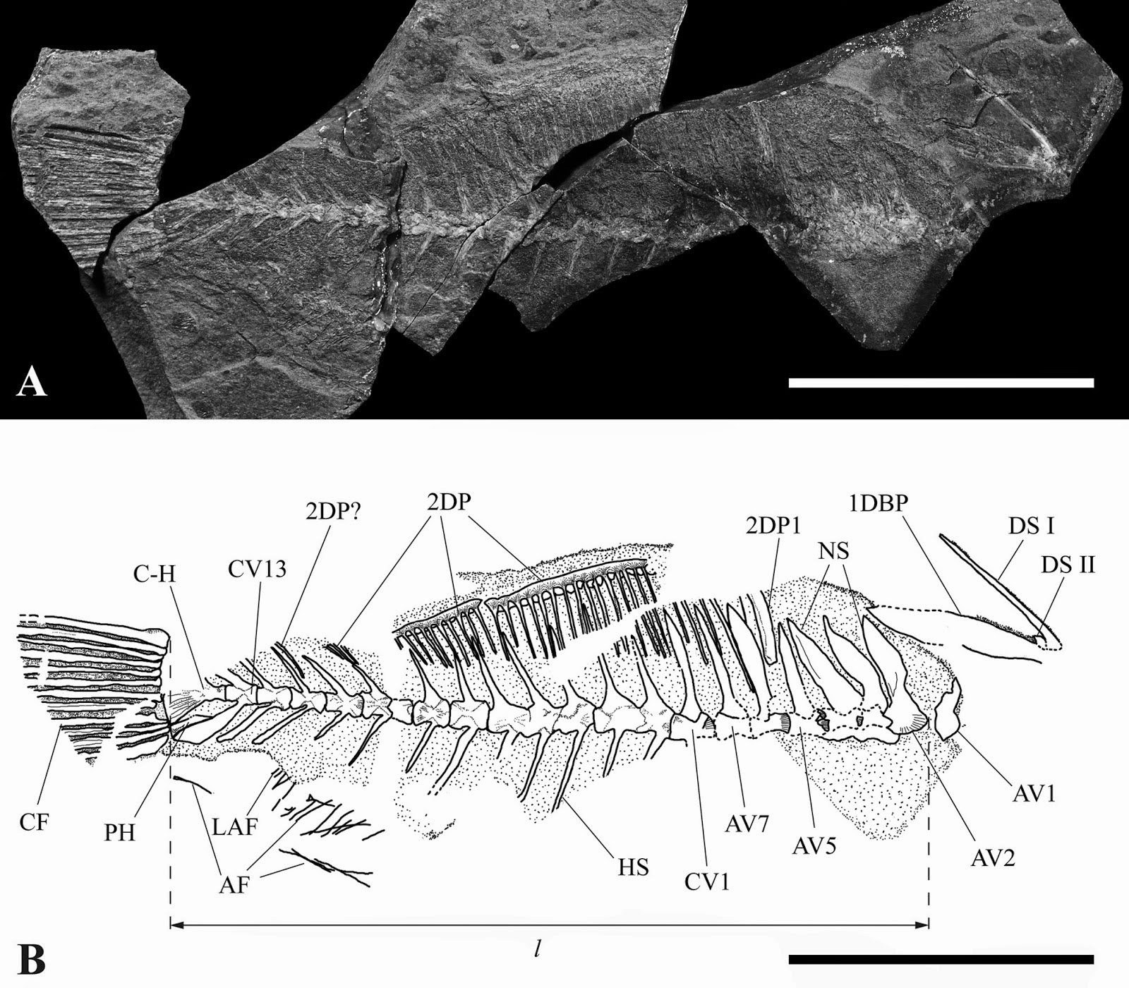
Two specimens of Kenyaichthys kipkechi from the Lukeino Formation ofthe Central Rift Valley of Kenya. Altner & Reichenbacher (2015).

Kenyaichthys kipkechiis considered to be distinctive enough to be placed in a new family of its own, the Kenyaichthyidae. This family is placed within the suborder Aplocheiloidei, where it is considered to be more closely related to the Rivulidae, today found only in South America, than it is to either the Nothobranchiidae and Aplocheilidae, which are both found in Africa today.

Altner and Reichenbacher also note that Kenyaichthys kipkechi appears to be quite a variable species, and note that many modern freshwater Fish are found in species flocks, groups of closely related species found living together with slightly different ecological niches. The suggest an alternative hypothesis, that Kenyaichthyskipkechimay represent a species flock rather than a true species, but do not make any attempt to subdivide the fossils into ecological or morphological groups.

They also note that many specimens of Kenyaichthys kipkechi appear to have suffered spinal deformations while alive. In modern Fish this is often a symptom of pollution, caused by the Fish being poisoned by heavy metals such as cadmium, copper and zinc. Such poisoning is most commonly associated with human activities, particularly mining and industry, but can also occur due to natural causes, such as weathering of metals from ore-rocks or volcanic emissions. The Lukeino deposits are not close to any known ore deposits, but were heavily influenced by periodic volcanic ashfalls, which have been associated with poisoning incidents in modern environements.

Examples of Kenyaichthys kipkechi showing spinal deformation.Altner & Reichenbacher (2015).

See also…

Halecomorphs are Neopterygid Fish (Ray-finned Fish) related to Ginglymodians (Gars) and Teleosts (almost all modern Ray-finned Fish). They are split into three groups, the extant Amiiformes, which contain a single living species, the Bowfin, Amia calva...
 
http://sciencythoughts.blogspot.co.uk/2014/06/a-fossil-filefish-from-middle-miocene.htmlA fossil Filefish from the Middle Miocene of Nagano Prefecture in central Japan.         Filefish (Monacanthidae) are  Tetraodontiform Fish related to Triggerfish, Pufferfish and Trunkfish. They are found throughout shallow tropical and temperate waters in the Atlantic, Pacific and Indian Oceans. They get their name from their rough skins which was supposedly once used for finishing surfaces by...
http://sciencythoughts.blogspot.co.uk/2014/04/a-freshwater-coccolepidid-fish-from.htmlA freshwater Coccolepidid Fish from the Late Jurassic of Patagonia.                            In 1943 palaeontologist Alejandro Bordas described a number of fossil freshwater Fish from a location in...

Follow Sciency Thoughts on Facebook.

Asteroid 2015 HC1 passes the Earth.

Asteroid 2015 HC1 passed by the Earth at a distance of 8 407 100 km (21.9 times the average distance between the Earth and the Moon, or 5.62% of the average distance between the Earth and the Sun), slightly after 10.15 pm GMT on Wednesday 29 April 2015. There was no danger of the asteroid hitting us, though had it done so it would have presented only a minor threat. 2015 HC1 has an estimated equivalent diameter of 6-21 m (i.e. it is estimated that a spherical object with the same volume would be 6-21  m in diameter), and an object of this size would be expected to explode in an airburst (an explosion caused by superheating from friction with the Earth's atmosphere, which is greater than that caused by simply falling, due to the orbital momentum of the asteroid) in the atmosphere between 38 and 21 km above the ground, with only fragmentary material reaching the Earth's surface.

  The calculated orbit of 2015 HC1. JPL Small Body Database.

2015 HT10 was discovered on 17 April 2015 (twelve days before its closest approach to the Earth) by the Dark Energy Camera on the Blanco 4-meter Telescope at the Cerro Tololo Inter-American Observatory in La Serena, Chile. The designation 2015 HC1 implies that it was the 28th asteroid (asteroid C1) discovered in the secondt half of April 2015 (period 2015 H).

While 2015 HC1 occasionally comes near to the Earth, it does not actually cross our orbital path. It has an elliptical 576 day orbit, at an angle of 1.97° to the plane of the Solar System, that takes it from 1.06 AU from the Sun (1.06 times the average distance at which the Earth orbits the Sun), slightly outside our orbit, to 1.64 AU from the Sun, (1.64 times the distance at which the Earth orbits the Sun and more than the average distance at which the planet Mars orbits the Sun). As a Near Earth Object that remains strictly outside the orbit of the Earth it is classed as an Amor Family Asteroid. This means that close encounters between 2015 HC1 and the Earth are quite common, with the next predicted for June 2067. The asteroid is thought to also have occasional close encounters with Mars, the last of which would have occured in August 2011.

See also...

Asteroid 2015 HT10 passed by the Earth at a distance of 627 100 km (1.63 times the average distance between the Earth and the Moon, or 0.42% of the average distance between the Earth and the Sun), at about 4.55 am GMT on Wednesday 29 April...
 
 
http://sciencythoughts.blogspot.co.uk/2015/04/asteroid-2015-hq11-passes-earth.htmlAsteroid 2015 HQ11 passes the Earth.     Asteroid 2015 HQ11 passed by the Earth at a distance of 490 100 km (1.27 times the average distance between the Earth and the Moon, or 0.33% of the average distance between the Earth and the Sun), slightly before 6.20 am GMT on Saturday 25 April...
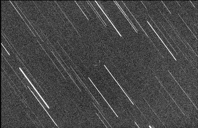
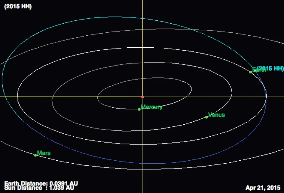
Asteroid 2015 HH passed by the Earth at a distance of 4 513 000 km (11.7 times the average distance between the Earth and the Moon, or 3.02% of the average distance between the Earth and the Sun), slightly after 10.25 am GMT on Tuesday 14 April 2015. There was...
Follow Sciency Thoughts on Facebook.