
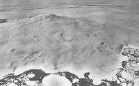
NASA's Landsat 8 satellite has recorded an eruption on Mount Sourabaya, a stratovolcano (cone shaped volcano made up of layers of ash and lava around a central vent) on Bristol Island in the South Sandwich Islands, the first eruption on the volcano detected since 1956. Volcanic eruptions on Bristol Island are seldom directly observed, as the island is uninhabited and largely covered by glaciers, with most historical observations having been made by whaling ships, which no longer ply the waters of the South Atlantic. Even with satellites observing eruptions in the South Sandwich Islands is difficult, as they are often covered by extensive cloud cover around Cape Horn. However the Landsat 8 satellite was able to observe the eruption using its Operational Land Imager instrument, which is able to see into the infrared part of the spectrum, enabling it to detect heat sources through heavy cloud cover. The eruption was first observed on 24 April 2016 when a plume the satellite observed a plume rising above the cloud layer at human visual wavelengths, together with a heat source below the clouds interpreted as flowing lava at infrared wavelengths. A second pass of the island on 1 May showed elongation of the heat source, suggesting lava flowing down the side of the mountain.

Landsat 8 image of eruption on Mount Sourabaya taken on 24 April 2016. Cloud cover and plume are at visible wavelengths, blue outline of Bristol Island and orange representation of heat-source detected at infrared wavelengths are visual enhancements. NASA/Earth Observatory.
The South Sandwich Islands lie along the eastern margin of the South Sandwich Microplate, and are fuelled by the subduction of the tip of the South American Plate beneath the South Sandwich Microplate along the South Sandwich Trench. As material from the South American Plate sinks deeper into the Earth it is melted by the heat of the planet's interior, with some of the melted material rising through the overlying South Sandwich Microplate to form the volcanoes of the South Sandwich Islands.

Second Landsat 8 image of Mount Sourabaya taken on 1 May 2016. Cloud cover is less extensive and heat source has become more elongate. NASA/Earth Observatory.
The South Sandwich Plate is being formed by spreading along the East Scotia Ridge, which separates it from the South Scotia Plate to the west. Along this fracture zone the two plates are being drawn apart and new lithospheric material is being formed by magma upwelling from the Earth's interior. This is thought to have been occurring for about 28.5 million years, and is one of a series of such ridges that have formed between the South American and Antarctic Plates as the two have been drawn apart over the last 40 million years, prior to this they were a single continental block.

Map of South Sandwich Plate (SAN) shows its position between the Scotia Plate (SCO), South American Plate (SAM) and the Antarctic Plate (ANT). There are also visible The East Scotia Ridge (ESR), South Sandwich Islands (SSI) and the South Sandwich Trench (SST). Rogers et al. (2012).
See also...
 Possible volcanic activity on Mount Siple, Antarctica. Mount Siple is one of the world's most remote volcanoes, located on
Siple Island, off the coast of Marie Byrd Land, Antarctica. It is a
shield volcano...
Possible volcanic activity on Mount Siple, Antarctica. Mount Siple is one of the world's most remote volcanoes, located on
Siple Island, off the coast of Marie Byrd Land, Antarctica. It is a
shield volcano...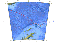 Series of Earthquakes in the South Shetland Islands. On Sunday 15 January 2012 at
approximately 9.40 am local time (1.40 pm GMT) Elephant Island in the
South Shetland Islands was shaken by an Earthquake measuring 6.6 on the
Richter Scale at a depth...
Series of Earthquakes in the South Shetland Islands. On Sunday 15 January 2012 at
approximately 9.40 am local time (1.40 pm GMT) Elephant Island in the
South Shetland Islands was shaken by an Earthquake measuring 6.6 on the
Richter Scale at a depth... New deep-sea hydrothermal vent ecosystem discovered in the Southern Ocean. Deep-sea hydrothermal vents (or 'black
smokers' are) areas where super-heated, mineral-rich water escape from
fissures in the Earth's crust into deep ocean water. They typically
occur on divergent plate margins (ocean ridges), where two tectonic
plates are moving apart...
New deep-sea hydrothermal vent ecosystem discovered in the Southern Ocean. Deep-sea hydrothermal vents (or 'black
smokers' are) areas where super-heated, mineral-rich water escape from
fissures in the Earth's crust into deep ocean water. They typically
occur on divergent plate margins (ocean ridges), where two tectonic
plates are moving apart...
Follow Sciency Thoughts on Facebook.
Sourabaya
Sourabaya
Sourabaya