
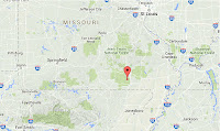
The United States Geological Survey recorded a Magnitude 3.5 Earthquake at a depth of 16 km beneath northern Ballard County, Kentucky, slightly after 1.10 am local time (slightly after 6.10 am GMT) on Sunday 1 May 2016. There are no reports of any damage or injuries associated with this event, but people have reported feeling it across Ballard and McCracken counties.

The approximate location of the 1 May 2016 Ballard County Earthquake. Google Maps.
Western Kentucky lies within an area known as the New Madrid Fault Zone, an
seismically active area which lies over the deeply buried Reelfoot Rift,
an area of tectonic expansion associated with the breakup of the
ancient supercontinent of Rodinia about 750 million years ago. This is
no longer an active rift, but it is an area of weakness within the North
American Plate which is more prone to movement in response to other
tectonic stresses, such as the compression of the plate by expansion
beneath the Atlantic and Pacific Oceans.
The
Reelfoot Rift is overlain by a deep layer of poorly consolidated
tertiary sediments. These sediments are prone to liquefaction during
tremors. When this occurs the sediments behave as a liquid, rather than a
solid, with often devastating consequences for man made structures such
as buildings and roads on the surface.

The structures underlying the New Madrid Fault Zone. Geological Survey of Alabama.
The
New Madrid Fault Zone gets its name from the New Madrid Earthquakes of
1811-12, which were felt over much of the central United States,
entirely destroying the city of New Madrid, Missouri, and causing damage
to buildings as far away as St Louis, Missouri and Memphis Tennessee as
well as diverting the course of the Mississippi River.
Witness
accounts of Earthquakes can help geologists to understand these events,
and the structures that cause them. The international non-profit
organization Earthquake Report is interested in hearing from people who may have felt this event; if you felt this quake then you can report it to Earthquake Report here.
See also...
 Magnitude 3.4 Earthquake in Ripley County, Missouri. The United States Geological Survey recorded
a Magnitude 3.4 Earthquake at a depth of 17 km, in northern Ripley
County, in southern Missouri...
Magnitude 3.4 Earthquake in Ripley County, Missouri. The United States Geological Survey recorded
a Magnitude 3.4 Earthquake at a depth of 17 km, in northern Ripley
County, in southern Missouri... Magnitude 3.6 Earthquake in Pemiscot County, southeast Missouri. The United States Geological Survey recorded
a Magnitude 3.6 Earthquake at a depth of 10 km, roughly...
Magnitude 3.6 Earthquake in Pemiscot County, southeast Missouri. The United States Geological Survey recorded
a Magnitude 3.6 Earthquake at a depth of 10 km, roughly... Magnitude 2.8 Earthquake in Dunklin County, Missouri. The United States Geological Survey
recorded a Magnitude 2.8 Earthquake at a depth of 7.7 km, roughly 4 km
to the west of the city of Malden...
Magnitude 2.8 Earthquake in Dunklin County, Missouri. The United States Geological Survey
recorded a Magnitude 2.8 Earthquake at a depth of 7.7 km, roughly 4 km
to the west of the city of Malden...
Follow Sciency Thoughts on Facebook.