
Seven people have been confirmed dead and an unknown number are still missing following a pyroclastic flow (avalanche of hot rock, ash and gas) that swept through farms and villages on the slopes of Mount Sinabung in North Sumatra on Sunday 22 May 2016. A number of other people are being treated for extensive burns following the event, with rescue teams still scouring the mountain.

Rescue workers searching a ash-covered village near Mount Sinabung, North Sumatra. Dedi Sinuhaji/EPA.
Mount Sinabung, a 2460 m stratovolcano (cone shaped volcano made
up of layers of ash and lava) in the Karo Regency; it is potentially a
very dangerous volcano, as a large number of people live in its
immediate vicinity. The last major eruption prior to the twenty-first
century happened in about 1600, with small eruptions occurring in 1889
and 1912. However the volcano returned to life in late August 2010,
erupting throughout September and causing about 12 000 people to flee
their homes.

The location of Mount Sinabung. Google Maps.
The
Indo-Australian Plate, which underlies the Indian Ocean to the west of
Sumatra, is being subducted beneath the Sunda Plate, a breakaway part of
the Eurasian Plate which underlies Sumatra and neighboring Java, along
the Sunda Trench, passing under Sumatra, where friction between the two
plates can cause Earthquakes. As the Indo-Australian Plate sinks further
into the Earth it is partially melted and some of the melted material
rises through the overlying Sunda Plate as magma, fueling the volcanoes
of Sumatra.

The Subduction zone beneath Sumatra. NASA/Earth Observatory.
The two plates are not directly impacting one-another, as occurs in the subduction zones along
the western margins of North and South America, but at a steeply
oblique angle. This means that as well as the subduction of the
Indo-Australian plate beneath the Sunda, the two plates are also moving
past one-another. This causes rifting within the plates, as parts of
each plate become stuck to the other, and are dragged along in the
opposing plate's direction. The most obvious example of this is the
Sumatran Fault, which runs the length of Sumatra, with the two halves of
the island moving independently of one-another. This fault is the cause
of most of the quakes on the island, and most of the island's volcanoes
lie on it.

The movement of the tectonic plates around Sumatra. NASA/Earth Observatory.
See also...
 Seventeen students confirmed dead after flash flood and landslide at popular Sumatran tourist spot. Seventeen students have been confirmed dead and another...
 Magnitude 7.8 Earthquake to the southwest of Sumatra triggers small tsunami. The United States Geological Survey
recorded a Magnitude 7.8 Earthquake at a depth of 10 km...
Magnitude 7.8 Earthquake to the southwest of Sumatra triggers small tsunami. The United States Geological Survey
recorded a Magnitude 7.8 Earthquake at a depth of 10 km...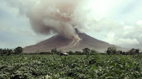 Eruption on Mount Sinabung. Residents of villages close to Mount Sinabung on North Sumatra have been
forced to evacuate their homes following two eruptions on the volcano
on Thursday 25 February 2016. The first eruption...
Eruption on Mount Sinabung. Residents of villages close to Mount Sinabung on North Sumatra have been
forced to evacuate their homes following two eruptions on the volcano
on Thursday 25 February 2016. The first eruption...Follow Sciency Thoughts on Facebook.