The Zechstein Sea was once a shallow marine basin that occupied much of the area covered by northeastern England, the North Sea, Germany and Poland during the Late Permian. It was connected to the Palaeotethys Ocean, and formed a shallow sea dominated by microbial reef systems. Towards the end of the period it repeatedly became cut off from the wider ocean and developed into a hypersaline basin similar to the modern Dead Sea, before vanishing completely. The Zechstein evaporite deposits are today mined for salt, gypsum, and potash in England, Germany and Poland. Carbonates preceding the vast accumulation of evaporites reflect changes in the basin hydrology and the degree of connection to the open sea. The resulting sequence of deposits mirrors a shift from normal marine to evaporitic conditions. In the Zechstein Basin microbial deposits abound in the uppermost part of the first Zechstein cycle carbonate, of middle Wuchiapingian age, both in marginal and central parts of the basin. Traditionally, the Zechstein Group is divided into cycles reflecting progressive evaporation: at the base of a cycle are normal marine sediments; these are followed by sediments indicative of increasing salinity, first sulphates, next chlorides and eventually potash salts. Traditionally, four evaporitic cycles were distinguished. The total stratigraphic thickness of the Zechstein deposits in the basin centre exceeds 1.5 km.
Microbial deposits are an essential component of Zechstein Limestone reefs, and their frequency increases upsection. Such a trend was regarded in the past as the record of increasing seawater salinity that eventually led to the deposition of sulphate evaporites. However, a recent study indicated that Echinoids are common throughout the Zechstein Limestone section except close to its top, suggesting that most of the Zechstein Limestone sedimentation was within the normal range of marine salinity and remained at roughly the same level. However, the evaporite drawdown effect caused significant salinity increase at the top of the Zechstein Limestone deposits. The eventual rise of salinity led to the onset of the evaporite deposition in the basinal facies. The sharp boundary between the Zechstein Limestone and the overlying sulphate deposits (Lower Anhydrite) in the basinal facies is due to the nature of evaporites that start to precipitate immediately when the brines reach saturation.

Lithostratigraphy and sequence stratigraphy of the basal Zechstein strata in southwest Poland. Peryt et al. (2020).
Peryt et al.'s choice of the study area was controlled by two factors. First, the uppermost part of the Zechstein Limestone and the transition Zechstein Limestone-Lower Anhydrite was cored in three boreholes (Jabłonna 1, 2, and 3) of four drilled in this particular reef. Secondly, both the Zechstein Limestone (except its uppermost part) and the Lower Anhydrite were characterized in detail in previous studies. Thus, this study fills a gap in the knowledge of depositional history at the carbonate-sulphate transition in the basinal setting.

Location of the study area. (a) The Zechstein Basin, asterisk shows the location of the Jabłonna Reef; (b) Palaeogeography of the Zechstein Limestone, rectangle shows the Wolsztyn reefs shown in (d); (c) The location of arbitrary line 2 showing the location of boreholes (black dots); (d) Reefs of the Wolsztyn palaeo-High; (e) Interpretation of Zechstein along the cross-section shown in (c). Abbreviations: Ca1, Zechstein Limestone reef; eva, evaporites (anhydrite and halite) of the PZ1 cycle (cyclothem); PZ1, PZ2, PZ3, Polish Zechstein cycles (cyclothems); Z₁𝇃, Z₁, Z₂, Z₃; Zechstein seismic reflectors. Peryt et al. (2020).
The Jabłonna Reef is one of many isolated reefs located on the elevated parts of the Brandenburg-Wolsztyn-Pogorzela High that is a part of the Variscan Externides consisting of strongly folded, faulted and eroded Visean to Namurian flysch deposits, capped by a thick cover of Upper Carboniferous–Lower Permian volcanic rocks. The reefs came into existence shortly after the rapid transgression of the Zechstein sea that flooded, probably catastrophically, this intracontinental depression located well below the contemporaneous sea level, some 257 million years ago. The rapid inundation allowed for almost perfect preservation of the uppermost Rotliegend landscape. The rapid inundation was succeeded by several rises in sea level, and thus the Zechstein Limestone section of the Wolsztyn palaeo-high may comprise only the younger part of the unit elsewhere.
The analysis of three dimensional seismic sections indicated that the Jabłonna Reef is composed of three parts: two small, roughly elliptical, and west northwest-east southeast elongated (penetrated by boreholes Jabłonna 3 and Jabłonna 4) and one large, elongated (penetrated by boreholes Jabłonna 1 and Jabłonna 2). Coeval Zechstein Limestone deposits in the depressions between and outside the reefs are thin (a few metres at most), and they are eventually underlain by the middle Wuchiapingian Kupferschiefer, one of the prime correlation markers in northwest and Central European stratigraphy. This unit records a period of basin-wide euxinic conditions, and can thus be considered an excellent time-marker.
The mineralogical composition of the Zechstein Limestone of the Jabłonna Reef varies, although limestone is the main rock type. Most of the Zechstein Limestone sections of the Jabłonna Reef is composed largely of bioclastic (mostly bryozoan) grainstones, and bryozoan and microbial boundstones that were formed in subtidal environments. The general shallowing-upward nature of deposition in the Jabłonna Reef area resulted in reef-flat conditions with ubiquitous microbial deposits in its central part. Subsequently, because of reef-flat progradation, the entire Jabłonna Reef area became a site of very shallow, subaqueous deposition. The uppermost part of the Zechstein Limestone, 2.8–5.1m thick, shows a breccia texture, and is the subject of Peryt et al.'s study.
The Lower Anhydrite consists of nodular anhydrite occurring at the base, which gradually passes into anhydrite with pseudomorphs after gypsum crystals. It is overlain by the Upper Anhydrite. In total, the thickness of PZ1 (Polish Zechstein 1) anhydrite in the Jabłonna Reef area varies from 59.2 to 66.0m; these are followed by PZ2-PZ4 (Polish Zechstein 2-Polish Zechstein 4) that are several 100m thick, and then by Triassic and Cainozoic deposits.
The reefs related to the Wolsztyn palaeo-high are excellent gas reservoirs, and part of their porosity owes its origin to freshwater flushing after deposition of the major part of the Zechstein Limestone and/or during the deposition. Certainly, the freshwater diagenesis occurred before the Lower Anhydrite deposition, as the subsequent geological history indicates that the reef deposits were continuously affected by marine-derived brines. Thus the geological history of the area rules out freshwater diagenesis after the onset of the PZ1 evaporite deposition on the top of the Jabłonna Reef.
Altogether 43.4m of core from three borehole sections: Jabłonna 1, Jabłonna 2 and Jabłonna 3 across the uppermost part of the Zechstein Limestone (15 m) and the Lower Anhydrite (41.3 m) were subjected to a detailed sedimentological analysis. Following detailed core measuring, 15 polished core samples and 40 thin sections were examined for sedimentological aspects of the Zechstein Limestone and to record the changes in the frequency of occurrence and the state of preservation of fossil taxa. Twelve thin sections were studied with cathode luminescence.
The uppermost part of the Zechstein Limestone in the Jabłonna 1 borehole is 4.0m thick (depth 2342.0–2346.0 m) and shows a brecciated nature. Clasts are usually sharp-edged and of very various, often centimetric sizes, and show the inclined arrangement. They are composed of limestone and dolomite showing various microbial textures and more rarely organo-detrital texture. These clasts are embedded in nodular anhydrite(−enriched) matrix, and sometimes are accompanied by fine sharp-edged clasts that commonly occur also in the strata underlying the brecciated top part of the Zechstein Limestone. This part of the section smoothly passes into fine nodular, bedded anhydrite that shows abundant carbonate content; the thickness of beds varies from a few to about 10 cm, and in places, the beds are slightly inclined. This portion is 3.2m thick and it gradually passes (0.6 m) into massive anhydrite with clear centimetric pseudomorphs after upright-growth gypsum crystals (this part of the sequence is 2.0m thick), followed by finenodular anhydrite (10.3 m thick). Then, anhydrite breccia (0.6 m thick) occurs, followed by recrystallised anhydrite of conglomeratic appearance (12.3 m thick) with locally occurring clear pseudomorphs after bottomgrowth gypsum crystals.

Samples of the uppermost Zechstein Limestone of the Jabłonna 1 borehole; the depths in relation to the top of Zechstein Limestone are: (a) 0.1 m, (b) 0.9 m, (c) 1.3 m, (d) 2.15 m, (e) 3.4 m, (f) 3.7 m, (g) 4.8 m. Abbreviations: an, anhydrite; dd, detrital dolomite; md, microbial dolomite. (a)-(c) Clasts of microbial carbonates and peritidal laminites within anhydritic and dolomitic matrix; (d) steeply inclined pisolitic dolomite; (e), (f) large clasts of microbial carbonate in nodular anhydrite; (g) microbial encrustations and cement crusts (arrowed) stabilising detrital deposit consisting of sharp-edge clasts, underlying the brecciated deposits shown in (f). Peryt et al. (2020).
In the Jabłonna 2 borehole, the breccias (2.8 m thick) consist of clasts of limestones (mostly Bryozoan grainstone and Stromatolite) in a dolomite matrix. In some instances, dolomicrite with quartz silt and micas (of aeolian origin?) were recorded. These breccias occur at a depth of 2345.4–2348.2 m. Due to the abundance of anhydrite nodules in the top 1.1 m, the transition to the Lower Anhydrite is, in fact, gradual. Above the conventional boundary, now placed at a depth of 2345.4 m, distinctively bedded nodular anhydrite (5.0 m thick) occurs, and the bedding is disclosed by dolomite laminae and lenses showing carbon¹³ and oxygen¹⁸ levels characteristic of the Zechstein evaporite formations. In the upper part of the section, a 2.4-m-thick interval composed of bedded nodular anhydrite occurs, which shows clear pseudomorphs after upright-growth gypsum crystals.

Aspects of the uppermost part of the Zechstein Limestone in the Jabłonna 1 borehole; the depths in relation to the top of Zechstein Limestone are: (a), (b) 2.8 m, (c) 2.4 m, (d)-(h) 0.1 m; Abbreviations: an, anhydrite; bs, Bivalve shell; fe, Foraminiferal encrustation; ga, Gastropod shell; me, microbial encrustation; os, Ostracod. (a), (b) Clast of recrystallised peloidal deposit showing relics of stromatolitic lamination and encrusting Foraminifers; arrow shows the carbonate crust with common pseudomorphs after lenticular gypsum crystals shown in (b); (c) Bivalve shells with microbial encrustations, Gastropods, Ostracods, encrusting Foraminifers and other small allochems in recrystallised micritic matrix and anhydrite cement (sample taken from a clast); (d) sample shown by X (3) above; (e)-(h) fragments of (d) showing aspects of microbial lamination (e), (f), (h) and encrusting Foraminifers (g), (h). Peryt et al. (2020).
The uppermost part of the Jabłonna 2 section resembles most of the underlying deposits consisting of granular sediments with inclined crusts of possible microbial laminites. However, due to dolomitisation and severe recrystallisation, these primary features are poorly (but still) visible. A complex diagenesis in this part of the section might account for the seemingly brecciated nature. But on the other hand, the occurrence, in the close neighbourhood, of clasts of rocks that originated in various environments indicates their transportation.

Polished section (a) and thin sections (b)-(d), uppermost Zechstein Limestone, Jabłonna 2 borehole (the depths in relation to the top of Zechstein Limestone are: (a) 0.6 m, (b) 1.4 m, (c) 1.7 m, (d) 2.2 m). Abbreviations: an, anhydrite; dl, detrital limestone; ml, microbial limestone. (a) Dolomite breccia composed of sharp-edged clasts of peritidal carbonates and, in the top part of the sample, nodular anhydrite; (b) microbial encrustations at the boundary of a clast composed of Bryozoan grainstone that is enclosed in nodular anhydrite; (c) recrystallised limestone composed of crinkle laminations and fine allochems; arrows show Bryozoan zoaria; (d) micritic dolomite showing laminae (arrow) and faint outlines of allochems, with abundant fine quartz grains (white dots) and rare fine mica flakes. Peryt et al. (2020).
The brecciated portion of the Zechstein Limestone in the Jabłonna 3 borehole is 5.1m thick and occurs at a depth of 2348.9–2354.0 m. The clasts show various sizes – from less than 1 mm to several cm. Clasts are accompanied by microbial laminations that also occur at the Zechstein Limestone-Lower Anhydrite boundary. They are overlain by nodular anhydrite (0.9 m thick) containing abundant dolomite in the matrix; the nodules show a clear upward trend toward the bedding arrangement. Next, there is bedded nodular anhydrite (2.4 m thick), most probably clastic, followed by nodular anhydrite with pseudomorphs after upright-growth gypsum crystals up to 2 cm high. The topmost 1.25 m of the cored interval consists of massive anhydrite with gypsum pseudomorphs up to 25 cm high.

Polished sections (a)-(d) and thin sections (e)-(g) from the uppermost Zechstein Limestone, Jabłonna 3 borehole; the depths in relation to the top of Zechstein Limestone are: (a) 0m, (b) 2.2 m, (c) 0.5 m, (d) 1.5 m, (e) 0.6 m, (f) 2.7 m, (g), (h) 3.8 m. Abbreviations: an, anhydrite; dd, detrital dolomite; ml, microbial limestone. (a) Zechstein Limestone–Lower Anhydrite boundary (dotted): microbial (thrombolitic) dolomite overlain by dolomite-rich anhydrite with anhydrite nodules; (b) clasts and microbial laminations steeply inclined within nodular anhydrite; (c), (d) clasts of various size in the anhydrite matrix; (e) aspect of microbial carbonate (filaments?); (f) sharp-edge fine clasts of microbial carbonate with isopachous cement; (g), (h) Stromatolitic encrustations on and accompanied by detrital deposit; X in (h) indicates the location of (g). Peryt et al. (2020).
In terms of mineralogy, the uppermost portions of the Jabłonna sections are generally dolomites with a variable contribution of anhydrite. They show a more complex mineralogical composition. Besides dolomite and anhydrite, they also contain calcite and a minor admixture of accessory minerals, such as celestite, fluorite and authigenic quartz.

Medium crystalline nonplanar unimodal dolomite with partly preserved primary fabrics (?boundstone–upper four images, bioclastic grainstone–lower four images). (a), (b), (e), (f) transmitted light microphotographs (plane-polarized light and crossed polars, respectively), (c), (g) cathodoluminescence images, (d), (h) backscattered electron images. Abbreviations: dol, dolomite; anh, anhydrite; fine red dots mark spots of microprobe analyses). The anhedral dolomite crystals are usually few tens of micrometres in size and exhibiting undulatory extinction in crossed polarised light. The dolomite is red with some yellowish patches in cathodoluminescence. Primary porosity is plugged with anhydrite cements. Fine crystalline (dolomicritic) patches in the image (a) are encrusting Foraminifers. Jabłonna 1 borehole, sample located 0.5m below the top of the Zechstein Limestone. Peryt et al. (2020).
Two main varieties of dolomite can be distinguished. The most common one is usually nonplanar mediumcrystalline, unimodal dolomite composed of anhedral crystals, mostly a few tens of micrometres in size, exhibiting undulatory extinction in crossed polarised light. However, planar euhedral dolomite crystals are also visible in places. The dolomite crystals are typically cloudy and are rich in inclusions. They show red cathodoluminescence with yellowish spots or zones in places. The dolomite crystals form massive mosaics or very cavernous masses plugged with coarsely crystalline anhydrite and sometimes coarsely crystalline calcite. In some cases, pores are lined by thin rims dolomite crystals. Dolomitisation was generally fabric-destructive and matrix- and grain-replacive, but remains of original fabrics are still traceable in places. The porosity may be in part both secondary (e.g. after dissolution of some components, e.g. fossils) and primary (e.g. original interparticle porosity); the cavernous portions mimic probably original sedimentary fabrics, such as the grainstone texture.

Coarse crystalline calcite (orange in cathodoluminescence) within medium crystalline dolomite (bright red in cathodoluminescence) with abundant anhydrite cementation. (a), (b), (e), (f) transmitted light microphotographs (plane-polarized light and crossed polars, respectively), (c), (g) cathodoluminescence images, (d), (h) backscattered electron images images. Abbreviations: cal, calcite; dol, dolomite; anh, anhydrite; fine red dots mark spots of microprobe analyses. The calcite crystals are probably burial cements that occlude porosity within dolomite. Jabłonna 3 borehole, sample located 0.6 m below the top of the Zechstein Limestone. Peryt et al. (2020).
The second type of dolomite in the sections studied, volumetrically subordinate, is finely crystalline dolomite (dolomicrite). Some fossils (e.g. sessile Foraminifers) or microbialitic fabrics are mimetically replaced by dolomite.
Calcite is present only in some of the thin sections studied. Petrographically, two calcite varieties can be distinguished: massive calcite mosaics and coarsecrystalline calcite cements distributed within dolomite.

Coarse crystalline calcite mosaic with numerous euhedral fluorite crystals. (a), (b) Transmitted light microphotographs (plane-polarized light and crossed polars, respectively); (c) cathodoluminescence image, (d) backscattered electron image. Abbreviations: cal, calcite; dol, dolomite; fl, fluorite; qtz, quartz; fine red dots mark spots of microprobe analyses. The clearer (inclusion-poor) crystals with distinct internal zonation pattern (orange in cathodoluminescence) are probably cements that occlude porosity within calcite mass composed cloudy (inclusion-rich) dull dark/nonluminescent in cathodoluminescence crystals. Scattered tiny crystals or irregular patches of dolomite (pinkish red in cathodoluminescence) occur within the calcite. Additionally, a euhedral quartz crystal is visible in the backscattered electron image (d). Jabłonna 1 borehole, sample located 0.5m below the top of the Zechstein Limestone. Peryt et al. (2020).
The calcite mosaics are composed of anhedral, medium to coarse crystals that are about 100 μm long; these were encountered only in one thin section derived from the lowermost breccia sequence in the Jabłonna 1 borehole. The calcite crystals usually appear cloudy due to numerous inclusions. Patches or aggregates of small dolomite crystals are chaotically dispersed throughout the calcite mosaics. Additionally, euhedral fluorite crystals are dispersed within the calcitic mosaics.
The second type of calcite is coarse calcite cements that fill the pores after the dissolution of some former crystals/skeletons or just the porosity within crystalline dolomite. They are very clear and translucent (inclusion-poor) in transmitted light and exhibit a faint pale-yellow/orange cathodoluminescence.
Based on petrographic studies, the uppermost portions of the Jabłonna sections studied experienced rather simple diagenetic history. They were affected by only one episode of pervasive dolomitisation that usually obliterated to a significant extent of its original textures. The dolomitisation resulted in one type of dolomite, usually nonplanar medium-crystalline dolomite. Such dolomite texture is thought to originate in a higher-temperature environment. It seems that the dolomitisation took place under shallow-burial conditions and could be a result of the seepage of brines that originated during the deposition of the PZ1 anhydrite, as it is generally constrained only to the uppermost portions of the Jabłonna sections studied. Downward the sections, calcite mineralogy prevails and the Jabłonna Reef deposits are still essentially limestones.
Spatially very limited calcite cementation postdates the dolomitisation. The calcite cements show the characteristics typical of higher-temperature burial diagenesis (large and inclusion-free translucent monocrystals, quite homogeneous in cathodoluminescence). Possibly, their crystallisation could be related to fluids released during gypsum-to-anhydrite transition (dehydration), which were relatively rich in calcium ions. Calcite cementation was followed by pervasive anhydrite cementation (in places preceded by, or undergoing simultaneously with, local celestite crystallization) that reduced the remaining porosity significantly.
The uppermost part of the Zechstein Limestone is, in general, much more altered diagenetically than the other parts of the Zechstein Limestone are. This is interpreted as due to two circumstances. The first is the early spelean-like diagenesis in a carbonate-evaporite salina in which the deposits of the uppermost Zechstein Limestone of the Jabłonna Reef have originated (this is discussed later in this paper). The second is its location in the neighbourhood of the anhydrite deposits being the screen for the ascending fluids. In general, dolomitization of the Wolsztyn reefs was polyphase, and this is particularly characteristic of this part of the profile.
Although microbial deposits often show the inclined (even to subvertical) position, this is probably related to the changing configuration of microbial reef complex in time, as it was previously demonstrated for the Westerstein Reef in the Harz Mountains. The alternative for a part of the inclination, in particular, accompanied by the occurrence of complex coated grains, is that they might have resulted during the development of teepee structures which might be expected in a very shallow subaqueous environment that was subject to quite common episodes of subaerial exposure. In any case, in contrast to the most part of microbial biofacies, the strata characterized in this paper cannot be related to the merely subtidal environments.
Peryt et al. assume that during the evaporative drawdown that resulted first in the deposition of thin microbial carbonate in the basinal sections, the Jabłonna Reef became subaerially exposed. Its top (and possibly slopes) became thus an emersion surface, which led to an irregular, karstified and brecciated relief surface related to a stratigraphic hiatus before the establishment of a salina environment in which the regolith became cemented by precipitated halite. Thus, the deposits composing the topmost part of the Zechstein Limestone actually derive from weathering and erosion of the microbial deposits of the uppermost part of the shallowing-upward sequence of the Zechstein Limestone and from precipitation of gypsum from transgressing brines of the sulphate system developed in the basinal facies.

Diagrammatic presentation of sea/brine level changes at the Zechstein Limestone/Lower Anhydrite boundary along the arbitrary seismic line. (1) progradational deposits; (2) degradational deposits; (3)–(4) progradational to aggradational deposits (3)–(4); (5) aggradational to retrogradational deposits: (1) Final stage of deposition of microbial deposits of the reef flat environment in Jabłonna 1. (2) Final stage of deposition of microbial deposits of the reef flat environment in Jabłonna 2 and 3; subaerial exposure in Jabłonna 1. (3) Stages (3a)-(3c) of sea level fall related to evaporative drawdown – subaerial exposure of the Jabłonna Reef and origin of fresh-water diagenesis and anhydrite cementation (possibly related to longer periods of stabilization of sea level during steps in sea level fall). (4) Deposition of microbial deposits in the top layer of the Zechstein Limestone in the basin. (5) Possibly the (beginning of) deposition of carbonate-enriched strata of the Lower Anhydrite. Peryt et al. (2020).
It was previously shown that the general shallowing-upward nature of deposition in the Jabłonna Reef area resulted in reef-flat conditions with ubiquitous microbial deposits in the central part of the Jabłonna Reef. Then, the reef flat started to prograde, and eventually, the entire Jabłonna Reef area became the site of very shallow, subaqueous deposition. Once the sea-level has dropped slightly, the Jabłonna 1 area became exposed first. At that time, shallow subtidal deposition still continued in the other parts of the Jabłonna Reef. Then, the areas at Jabłonna 2 and Jabłonna 3 became exposed, possibly due to the ongoing fall of sea level.
The result of the long subaerial exposure of the Jabłonna Reef was the origin of an emersion surface and an irregular, karstified and brecciated relief. The length of the stratigraphic hiatus before the establishment of the salina environment is difficult to ascertain. In fact, there is no accord about the length of individual Zechstein formations and members, and even of the entire Zechstein, but Peryt et al. assume that it possibly took a few 100 000 years.
The duration of this exposure is difficult to specify because of several reasons. First, the depositional duration of the Zechstein and its particular cycles is subject to debate, but the estimate that the Z1 phase was about two million years long seems valid. Second, there are substantial differences in the rate of deposition of carbonates and evaporites. Subaquatic sulphates often have the accumulation rates in the order of 1–40 m per thousand years, and the rate of chloride deposition is 4–5 times greater. The duration of the deposition of the Zechstein Limestone has been estimated at about 400 000 years, based on the average rate of deposition of platform carbonates, but it did not include the time of subsequent exposure of marginal carbonate platform (and the reefs of the Wolsztyn palaeo-High). Considering the scale of freshwater diagenesis, the length of the exposure was presumably similar to the range of Zechstein Limestone deposition.
Microbial carbonates are the primary lithology in the uppermost part of the Zechstein Limestone of the Jabłonna Reef. The increase in the amount of microbial deposits upsection was regarded in the past as the record of increasing seawater salinity that eventually led to the deposition of sulphate evaporites. However, a recent study of basin sections indicated that, for the most part of the Zechstein Limestone sedimentation, the salinity remained at roughly the same level of normal seawater until it increased due to the evaporite drawdown effect at the very end of the Zechstein Limestone deposition. Then, the salinity increase eventually led to the onset of the evaporite deposition in the basinal facies.
Microbial carbonates also abound in the shelf-edge reef of the English Zechstein, where Algal Stromatolites and diverse laminar encrustations form up to 90% of reef-flat rock. Thus, in biofacies terms, this part of the Zechstein Limestone is dominated by Stromatolite biofacies. Microbial carbonates occur in situ, and they compose the majority of clasts. However, also clasts of Bryozoan grainstones occur. These rocks are typical for the biofacies occurring below the Stromatolite biofacies that formed in low-energy (indicated by in situ, or almost complete overthrown, zoaria) and occasional high-energy (indicated by intercalations of coquinas) lagoonal environments. These lagoons could evolve into salinas, possibly when the communication with the basin became cut off. Accordingly, there were many environmental perturbations prior to the evaporative drawdown.
The microbial carbonates that developed in the uppermost Zechstein Limestone throughout the basin are commonly not coeval, though. A thin packet of microbial deposits occurring at the topmost part of the basinal sections of the Zechstein Limestone originated following the sea level fall at the end of the Zechstein Limestone deposition. The deposition of peritidal carbonates in the basinal facies was accompanied by subaerial emergence of the marginal carbonate platform (and the reefs related to the Wolsztyn palaeohigh). Subsequently, as a result of a basin-wide deepening-upward trend recorded in the Lower Anhydrite, the deposition of the Lower Anhydrite began at the reef zone. Such a scenario explains well the gradual change from carbonate to sulphate deposition in the Jabłonna Reef. The change took place in shallow salinas, i.e. in the same environment in which the oldest sediments of the Lower Anhydrite formed close to the Wolsztyn reefs, in the area characterized by condensed sequences. This leads to the conclusion that the uppermost part of the Zechstein Limestone in the reef area postdates the uppermost Zechstein Limestone in the basinal area. As recently commented, 'the dynamic relationships between marine and freshwater systems on carbonate platforms and their responses to sea level rise remain poorly understood. This is surprising given the frequency of platform exposure and flooding events seen in the stratigraphic record.' Considering that the flooding of the Zechstein reefs was executed by saline brines, and that the freshwater system has formed during subaerial exposure of the reefs, a much more complex fluid and diagenetic history can be expected than in the case of marine transgression. During transgression, the displaced freshwater lens created an extensive freshwater and brackish system, a transitional deposystem from marine to non-marine carbonate deposition.
The sharp boundary between the Zechstein Limestone and the overlying Lower Anhydrite in the basinal facies represents the nature of evaporites that start to precipitate immediately when the brines reach saturation. The increase in seawater salinity, which eventually led to evaporite precipitation, occurred during the deposition of the uppermost (about 10 cm thick) unit of the Zechstein Limestone in basinal facies, during the sedimentation of heterogeneous deposits composed mainly of ill-sorted oncoids and peloids with Stromatolites, above the last occurrence of Echinoids. This increase in seawater salinity was accompanied by sea level fall (evaporite drawdown). The coeval deposits of the reef (shoal) facies experienced some effect of this general increase in salinity, but it was controlled largely by local conditions in the environment of reef flat where considerable fluctuations in salinity might be expected. In general terms, this environment can be compared to Lake MacLeod and other Australian salinas
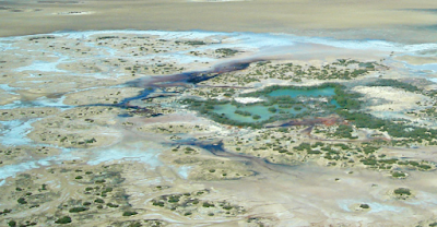
Lake MacLeod has a unique karst system, made of coastal limestone, which passes water from the Indian Ocean, 18 km underground using a hydrostatic pressure system, to bring salty water through sinkholes and vents into the lake basin. The lake surface is below sea level and water in the sinkholes and vents
may be several metres deep. The sinkholes are connected by channels to a
system of permanent mudflats, lagoons, and marshes, which can be up to a
metre deep. As water travels through sinkholes, it evaporates creating a
hypersaline environment when it reaches the terminal lagoon. Because of
the variable environmental conditions, pond areas can vary
substantially. The Northern Ponds area of Lake MacLeod include
intermittently inundated flats, with water matching the ocean’s salinity
coming through seepage vents. Freshwater enters though inflow from the
Lyndon and Minilya Rivers. This mixture of the two sources makes
Lake MacLeod as a brackish water environment. Gnaraloo Wildlife Foundation.
The uppermost part of the Zechstein Limestone in the Jabłonna Reef abounds in nodular anhydrite that forms the matrix in which carbonate clasts are embedded. However, in places the matrix is predominantly or entirely dolomitic. The lowermost Lower Anhydrite is also nodular, which otherwise is common for the entire Zechstein Basin. But we assume that this is a diagenetic fabric, and the original sulphate mineral was gypsum. In Jabłonna 1, some clasts have been encrusted by microbial mats containing pseudomorphs after lenticular gypsum crystals that have originated in a shallow subaqueous environment, most probably in relation of the transgressive Lower Anhydrite.
In the lower part of the Lower Anhydrite in the basinal facies, there is a unit rich in carbonate composing streaks and discontinuous laminae. The increased carbonate content in this unit can be related to either the dissolution phase of the Jabłonna Reef or the onset of the deposition on the Jabłonna Reef top after the evaporative drawdown. In the Ruchocice 4 section, located east of the Jabłonna Reef, thin microbial deposits (25 cm) of the Zechstein Limestone are followed by nodular anhydrite of the Lower Anhydrite, which contains intercalations of microbial dolomite in its lowermost part. These may correspond to unit B of the Lower Anhydrite in more basinal locations. In any case, the transgressive nature of the Lower Anhydrite is indubitable. In addition, the deposition of chloride deposits contemporaneous with sulphate deposits occurred quite early in the PZ1 history.
In some locations, microbial deposits were lacking in the upper part of the Zechstein Limestone. This was interpreted as due to lowering of the tectonic blocks on which the buildups were located, which could have resulted in the cessation of intensive carbonate deposition characteristic of reefs.
The subaerial exposure of the reefs and the marginal carbonate platforms in the basin centre is a logical consequence of sea level fall at the end of the Zechstein Limestone deposition, which was related to evaporative drawdown. This major sea level fall could be preceded by earlier sea level falls that have been concluded by several authors based on sedimentary and diagenetic premises. However, there is no doubt that the most important factor, in terms of duration and impact of poroperm properties, was the sea level fall related to the change from a marine carbonate to an evaporite basin. Large parts of the Hessian Basin became subaerially exposed for a long period of time, as is indicated by common karstification. Widely developed shallowing-upward peri-littoral, sabkha and salina successions in the Hessian Basin have been interpreted as an indication of a renewed rise of brine level (a transgressive systems tract) due to inflow of preconcentrated brines from the Southern Zechstein Basin to the north. This inflow was preceded by the development of a karstic, subaerial exposure surface, interpreted as a record of type-1 sequence boundary that formed during a distinct brinelevel fall.
In turn, Stromatolitic facies of the transition interval are contained between carbonate platforms or isolated carbonate buildups. The overlying evaporites showed no evidence of subaerial exposure and formed during a relative sea level rise as transgressive systems tract or early highstand systems tract deposits. They commented, however, that it is highly likely that the thick evaporites in the basin centre formed during local or global sea level lowstands. Peryt et al.'s data indicate that a subaerial exposure episode existed, in the study area, after the deposition of transitional Stromatolitic facies in the uppermost part of the Zechstein Limestone, and the regolith can be related to falling stage systems tract deposits, that can be correlated with the lowest Anhydrite unit in the salt basin located to the northeast of the Jabłonna Reef.
A previous studyindicated a good lateral correlation of anhydritized zones in the reefs, which was regarded as an evidence in favour of their syndepositional origin, namely during sea level falls that have been recorded in the marginal Zechstein Limestone carbonate platform. Another possible mechanism is that the anhydrite zones record the brine-level stands during the abrupt lowering of relative sea level at the end of Zechstein Limestone deposition, or they represent a longer stabilization of brine level during the transgression of the Lower Anhydrite.
Peryt et al. conclude that the thin (2.8–5.1 m) unit of brecciated limestones and subordinate dolomites at the top part of the Zechstein Limestone (Wuchiapingian) in the Jabłonna Reef in western Poland recorded a sudden sea level fall that resulted in a long subaerial exposure of the reef, followed by a slow brine-level rise. This unit, regarded as a regolith, originated during the sea level fall related to evaporative drawdown. Eventually, it was locally reworked during the Lower Anhydrite transgression. Therefore, it can be regarded as a transgressive lag deposit.
The highstand systems tract deposits of the Zechstein Limestone are followed by transgressive systems tract deposits of the Lower Anhydrite in the Jabłonna Reef. The regolith can be related to falling stage systems tract deposits that can be correlated with the lowest anhydrite unit in the salt basin adjacent to the Jabłonna Reef.
The dolomite composing the unit studied originated through the seepage of brines in shallow-burial conditions during the deposition of the PZ1 anhydrite.
The nature of primary sulphate mineral in the lowermost Lower Anhydrite is enigmatic, but it is probable that cyclic gypsum upright-growth deposition occurred in salinas developed during deposition of microbial flats at the final stage of deposition of the Zechstein Limestone, and, consequently, sulphate deposition in the reef area could predate the sulphate accumulation in the basin area.
The complex hydrological setting of the reef controlled its early diagenesis. During the sea level fall, the Jabłonna Reef became exposed and subjected to freshwater diagenesis that improved poroperm characteristics of reef reservoirs. During the sea level fall or/and during subsequent transgression of the Lower Anhydrite, the reefs were subjected to intense anhydrite cementation, although its overall impact on the porosity was quite limited.
The studied case implies that important environmental perturbations related to sea/brinelevel fluctuations existed at the transition from carbonate to evaporite deposition in other giant evaporite basins.
See also...


%20(1)%20(1).png)