Showing posts with label Sedementology. Show all posts

Tuesday, 23 July 2024

Curiosity rover detects elemental sulphur on Mars.

NASA's Curiosity Rover has detected crystals of elemental sulphur on the surface of Mars, the first time sulphur has been detected as a pure element on the planet. The crystals were observed at a location within Gale Crater called Convict Lake on 7 Jun 2024, and form a patch about 12 cm across. The crystals are thought to have been exposed by the rover itself driving over a rock and crushing it several days previously.

A patch of minerals including crystals of pure elemental sulphur on the surface of Mars. The image has been colour enhanced to for the benefit of Human eyes; the rover used an X-ray spectrophotometer to detect the element. NASA/JPL/CalTech/Malin Space Science Systems

The presence of sulphur on Mars is hardly surprising not surprising. The element is one of the most common in the universe and has been detected on all planets in the Solar System, as well as meteorites, asteroids, and comets. But most sulphur previously found on Mars has been in the form of sulphate salt evaporites, which formed as lakes and other bodies of water dried out on the surface of the planet long ago.

On Earth, sulphur deposits typically take the form of sulphates (the oxidised form of the mineral) or sulphites (the reduced form) with elemental sulphur forming in sedimentary rocks through the actions of sulphur-reducing micro-organisms in anaerobic (i.e. oxygen free) environments, and in volcanic rocks by the reaction of gaseous hydrogen sulphide and sulphur dioxide. The geology of Gale Crater is dominated by sedimentary deposits, including evaporites, but is generally low in sulphates. 

It is possible that the Convict Lake rock is of volcanic origin, and reached the Gale Crater locality as ejecta. However, the images of the rock resemble the surrounding sedimentary rocks, making it more likely that it is local in origin. This makes it likely that the sulphur has been derived from an original sulphate source in some way, although this does not necessarily imply the presence of sulphur reducing micro-organisms, as in the oxygen-free atmosphere of Mars, abiotic reducing reactions impossible on Earth become far more likely.

See also...

Wednesday, 3 April 2024

Living Stromatolites from Sheybarah Island, Saudi Arabia.

Fossil Stromatolites form some of the earliest evidence for life on Earth, being present in deposits from the Palaeoproterozoic and Archaean, with the oldest known examples currently dated to about 3.48 billion years ago. However, their importance has declined in the Phanerozoic, forming significant proportion of carbonate reefs only for brief periods following the End Ordovician and End Permian extinctions. Stromatolites still exist today, and understanding formation presents us with the possibility of understanding some of the oldest ecosystems on Earth, although modern forms are generally restricted to extreme environments, such as hypersaline marine settings and alkaline lakes, with living Stromatolites only known from two modern open-marine environments, Shark Bay in Western Australia and in the Exuma Islands of the Bahamas. 

In a paper published in the journal Geology on 15 February 2024, Volker Vahrenkamp and Viswasanthi Chandra of the Physical Sciences and Engineering Division at King Abdullah University of Science and Technology, Elisa Garuglier and Ramona Marasco of the Biological and Environmental Sciences and Engineering Division at King Abdullah University of Science and Technology, Kai Hachmann, also of the Physical Sciences and Engineering Division at King Abdullah University of Science and Technology,  Pankaj Khanna of the Department of Earth Sciences at the Indian Institute of Technology GandhinagarDaniele Daffonchio, also of the Biological and Environmental Sciences and Engineering Division at King Abdullah University of Science and Technology, and Alexander Petrovic, again of the Physical Sciences and Engineering Division at King Abdullah University of Science and Technology, and of Carmeuse, describe the discovery of a colony of living Stromatolites in the intertidal zone on Sheybarah Island on the Red Sea coast of Saudi Arabia.

Sheybarah Island forms part of the Al Wajh Carbonate Platform on the northwest coast of Saudi Arabia. The Al Wajh Carbonate Platform is connected to the Arabian mainland, and is enclosed by a 115 km reef-shoal belt. The central part of the platform hosts a lagoon with a maximum depth of 42 m, which is surrounded by 92 islands and patch-reefs. Sheybarah Island is located on the southwest edge of this platform, and has an area of 27 km², with a maximum elevation of 2 m above sealevel. The lagoon-facing rim of the southern slope of the Al Wajh Carbonate Platform is dominated by Mangroves, behind which is a sandy and rocky, then a rocky reef flat facing towards the open sea.

(A) Location of study area in northern Red Sea. (B) Sheybarah Island on the southwest Al Wajh Carbonate Platform. White arrows indicate prevailing wind direction based on annual average wind data over 10 years. (C) Location of Stromatolite field at southwestern extent of Sheybarah Island. Vahrenkamp et al. (2024).

The Red Sea is semi-enclosed, with slow surface-water renewal, creating a low nutrient environment. In the northeast part of the Red Sea, the average surface temperature is typically about 28°C during the summer, falling to about 23°C in winter, and surface salinity can reach 41‰. Prevailing winds come from the north-northwest, with an average windspeed of 4 m per second, although in winter strong southwesterly winds sometimes occur. The prevailing winds bring with them a high load of iron-rich sediment.

The presence of Stromatolites on Sheybarah Island was discovered during a scouting visit made to the island in January 2021. The Stromatolites form a field in the intertidal to shallow subtidal zone, on a flat slope which dips towards the sea, formed from a fossil Coral reef. A core drilled into this reef produced a radiocarbon date of 5264 years before the present, suggesting that it was formed during the Holocene sealevel highstand, between 4000 and 8000 years ago, when sealevels in the area would have been about 2 m higher than today. The surface of this reef is eroded, presumably due to modern wave action lowering the flat upper reef to the modern sealevel. A lithified sand layer beneath the Stromatolites yielded a date of 1640 years before present, which dates obtained from laminations within the Stromatolites ranged from 120 to 325 years before the present. This implies that the onset of Stromatolite growth was no more than 300-400 years ago; it is possible that it was more recent and that sand grains from a now absent upper layer have been incorporated into the Stromatolite structure.

Stromatolite samples being collected from the location. Vahrenkamp et al. (2024).

The tidal range in the area where the Stromatolites are growing is typically 50-60 cm, with a maximum of about 1 m, although occasional storm surges can inundate lower lying parts of the island. Sea temperatures measured at a depth of 5 m varied between 21°C and 31°C over the course of a year, though in the intertidal zone the temperature variation was much higher, between 8°C and 48°C, as very shallow seawater was exposed to highs of day time and lows of night time air temperatures. Salinity measured in March was 42‰; at the same time the water pH was 7.8 and dissolved oxygen was 5.9 mg per litre.

The Stromatolites are found over an area of about 50 000 m³, which could be divided into three zones, upper intertidal or beach-adjacent, mid-intertidal, and shallow subtidal, each of which was dominated by Stromatolites of a different morphotype. Stromatolites in the beach-adjacent zone, referred to as Type 1 Stromatolites, tend to be grey-green to dark brown in colour, and elongated-sinusoidal to rhomboidal in shape, aligned so that their long axis is perpendicular to the predominant wave crest direction. These tend to be less than 15 cm high, 5-50 cm wide, and 10-100 cm long, although they often coalesce into larger structures, which can be as much as 10 m long. The surface of these Stromatolites tends to be pustular in texture, and their interiors fairly well lithified. The Stromatolites of the mid-to-lower intertidal zones, referred to as Type 2 Stromatolites, are flatter, reaching a maximum of about 5 cm  in height, forming irregularly shaped, ovoid to tabular clusters which can cover as much as 100 m³. The base of these Stromatolites is often raised above the platform, on a small column of eroded Holocene Coral. In the lower intertidal to shallow subtidal zones Type 3 Stromatolites are low relief and poorly lithified, and often covered by a thin layer of carbonate sand.

(A) Drone survey image of Stromatolite fields, showing three main morphotypes of Stromatolites and their distributions. (B)–(C) Type 1 Stromatolites in upper intertidal zone, with elongated sinusoidal to rhomboidal morphology, laminated internal structures, and pustular exterior. White arrows show grazing Gastropods during high tide (underwater photo). (D)–(E) Type 2 Stromatolites, consisting of low-relief, irregularly shaped ovoid clusters of Stromatolites in the outer field. (F)–(G) Type 3 Stromatolites, composed of less-defined, low-relief microbial mats covered by a thin coating of carbonate sand. Vahrenkamp et al. (2024).

The internal structure of Type 1 Stromatolites was found to be laminated, with undulating layers of sediment interspersed with layers with clotted fabrics and vugs (cavities lined with mineral crystals), which in the fossil record would be interpreted as Thrombolitic Stromatolites. When sections of this material were cut and washed, dense lithified layers stood out in relief. Grazing organisms such as Gastropods were often trapped in the matrix. Millimetre scale microlitic crusts (microbially derived calcium carbonate crusts) alternated with millimetre scale sediment layers, within which lithification was beginning to break down grain boundaries. These grain layers often showed high levels of microboring, suggesting ongoing micritization even after sediment accretion.  Rim cements contained numerous aragonite needles, while microlitic crusts were predominantly aragonite (85%), with significant proportions of high magnesium calcite (9%) and low magnesium calcite (5%), and small amounts of quartz and clay minerals.

(A) Hand sample of Type 1 Stromatolite demonstrating layered structures. (B) X-ray micro–computed tomography (µCT) X-Z cross-section image of Type 1 Stromatolite exposing denser internal laminations (red). Colour bar represents range of µCT values corresponding to CT density; blue represents a void. (C) Thin-section micrograph illustrating micritic crust at surface of Stromatolite. (D) Millimetre-scale lithified sediment grain layers (yellow arrows) and fused grains (green arrows). (E) Grains infested with microborings near outer rims and fused at grain contacts (green arrows). (F) Acicular needle aragonite cements (AA) formed around the grain (G) rims. Vahrenkamp et al. (2024).

Examined through a scanning electron microscope, filamentous Cyanobacteria appeared to be the most abundant organisms within the structure of the Stromatolites, enveloping sediment grains in single strands of bundles, covered with mucous sheaths made up of excreted biological polymers. These filament and biopolymer masses also contained large numbers of sub-micron sized calcium and magnesium carbonate crystals. Also present were biofilm structures with Bacterial cells, and Navicula-like Diatoms. The upper and lower surfaces of the topmost microbial mat included numerous reticulated filament structures. An investigation into the biodiversity of the mats using 16S rRNA gene metabarcoding found that the most abundant micro-organisms were Proteobacteria, which made up 49% of the total (30% Alphaproteobacteria, 12% Gammaproteobacteria, and 7% Deltaproteobacteria), with Cyanobacteria making up 16% of the total, and Bacteroidetes 11%.

(A)–(E) Representative scanning electron micrographs showing (A) extensively microbored sediment grains (MG) wrapped in cyanobacterial filaments and extracellular polymeric substance (EPS) films (arrows); (B) High magnesium calcite microcrystals (triangles) associated with Cyanobacterial filaments; (C) filamentous structures, possibly bunches and strings of Cyanobacteria (black arrows), and single cells of various shapes (white arrows) surrounded by desiccated EPS; (D) filamentous structures of different dimensions (black arrows), surrounding bored surface of sand grain. A Diatom is also present (white arrow); and (E) reticulated filaments (black arrows) surrounded by copious amounts of EPS (white arrows). (F) Microbial diversity of Sheybarah Island Stromatolites. Vahrenkamp et al. (2024).

The presence of Stromatolites on the intertidal platform of Sheybarah Island appears to be driven by environmental factors. The platform surface here is exposed to frequent wetting and drying cycles, as well as extreme temperature fluctuations, with generally low current conditions, apart from the occasional storm event. Similar conditions are found on the other islands of the Al Wajh Carbonate Platform, making it likely that these to are home to Stromatolite colonies. The conditions here are similar to those found in the Exuma Islands of the Bahamas, where Stromatolites are also found; the much lower profile of the Sheybarah Island Stromatolites (never more than 15 cm high) probably reflect the limited tidal range of the Red Sea.

Growth of the Sheybarah Island Stromatolites appears to be driven by microbial activity, which leads to the accretion and differential lithification of sediment grains. The range of structures observed appears to be driven by a cycle of grain-entrapment followed by sedimentation, similar to that which has been documented in the Bahamas. The microbial community within the Stromatolites appears to be made up of a combination of photoautotrophic organisms (Cyanobacteria), and heterotrophic organisms, including ones capable of reducing sulphates.

The reticulated filaments seen in the Sheybarah Island Stromatolites are a surprising structure. Such filaments have previously been observed in microbial mats from aphotic environments, such as caves. At Sheybarah Island they appear to be ubiquitous in the upper layer of Stromatolites, and have a variety of morphologies, including horizontal ridges supported by vertical columnar structures. The nature and composition of these filaments is unclear, and will be the subject of future research.

Vahrenkamp et al. believe the Sheybarah Island Stromatolites to be the first open marine Stromatolites discovered in the Middle East, providing a new opportunity to study structures sparsely distributed on the modern Earth, but which were an important part of the Earth's earliest ecosystems. To date, the Stromatolites of the Bahamas have been considered the best analogue for the shallow-marine Stromatolites which formed throughout the Proterozoic, making the similar, but not identical, Stromatolites from Sheybarah Island a significant discovery with the potential to greatly enhance our understanding of Proterozoic ecosystems.

See also...

Tuesday, 16 May 2023

Evidence of recent liquid water at low latitudes on Mars.

The surface of Mars today is a hyperarid desert, yet in many places has features apparently formed by liquid water. It is now generally accepted that liquid water was present on early Mars, when the planet had a very different atmosphere. However, that early atmosphere has subsequently disappeared, and it is now assumed that the atmospheric pressure on Mars is now to low for liquid water to form.

This being the case, it came as a great surprise to scientists when, in March 2009, droplets of liquid were observed on one of the robotic arms of NASA's Phoenix Rover. Studies of the data recovered by Phoenix eventually concluded that the conditions for hypersaline water could exist on Mars at high latitudes during the summer, when the temperature rose above the melting point of such solutions (which is significantly lower than 0°C), resulting in a freeze-thaw cycle that might help to explain some of the features seen in these regions. 

However, the wider presence of apparent water features, such as slope lineae and gullies, is harder to explain. This had led scientists do develop alternative explanations, under which such features could have developed under dry conditions, since it is difficult to understand how sufficient liquid water could be present on the surface of Mars to explain features such as slope flows hundreds of metres in length. This disparity between a theoretical presence of small amounts of water on Mars, and a necessity to invoke dry formation of features we would typically associate with the presence of large amounts of water on Earth, makes it necessary to study smaller (less than one metre) features on Mars's surface in order to understand the planet's hydrological conditions properly. This is particularly true of features at lower (i.e non-polar) latitudes, where milder conditions make a freeze-thaw cycle unlikely, and there is a higher potential for the presence of some form of microbial life.

The China National Space Administration's Zhurong Rover landed on the southern Utopia Planitia on 15 May 2021, and spent nine months exploring the Late Hesperian northern lowlands, including studying the microstructure and chemical composition of the dune features observed there.

In a paper published in the journal Science Advances on 28 April 2023, Xiaoguang Qin of the Key Laboratory of Cenozoic Geology and Environment at the Institute of Geology andGeophysics of the Chinese Academy of Sciences, Xin Ren of the Key Laboratory of Lunarand Deep Space Exploration at the Chinese National Astronomical ObservatoriesXu Wang, also of the Key Laboratory of Cenozoic Geology and Environment at the Institute of Geology and Geophysics of the Chinese Academy of Sciences, Jianjun Liu, also of the Key Laboratory of Lunar and Deep Space Exploration at the Chinese National Astronomical Observatories, Haibin Wu, again of the Key Laboratory of Cenozoic Geology and Environment at the Institute of Geology and Geophysics of the Chinese Academy of Sciences, and of the  College of Earth and Planetary Sciences at the University of Chinese Academy of Science, Yong Sun of the Institute of AtmosphericPhysics of the Chinese Academy of Sciences, Zhaopeng Chen, again of the Key Laboratory of Lunar and Deep Space Exploration at the Chinese National Astronomical Observatories, Shihao Zhang, also of the Key Laboratory of Cenozoic Geology and Environment at the Institute of Geology and Geophysics of the Chinese Academy of Sciences, Yizhong Zhang, Wangli Chen, Bin Liu, Dawei Liu, and Lin Guo, again of the Key Laboratory of Lunar and Deep Space Exploration at the Chinese National Astronomical Observatories, Kangkang Li, again of the Key Laboratory of Cenozoic Geology and Environment at the Institute of Geology and Geophysics of the Chinese Academy of Sciences, Xiangzhao Zeng, Hai Huang, Qing Zhang, Songzheng Yu, and Chunlai Li, again of the Key Laboratory of Lunar and Deep Space Exploration at the Chinese National Astronomical Observatories, and Zhengtang Guo, once again of the Key Laboratory of Cenozoic Geology and Environment at the Institute of Geology and Geophysics of the Chinese Academy of Sciences,  present the results of a study of the surficial microstructure, morphology, and chemical compositions of dunes studied by the Zhurong Rover, and the implications of these results for the possibility of liquid water having existed on the surface of Mars at low latitudes in the recent past.

A series of detached barchan (crescent-shaped) dunes with sinuous profiles are present in the Zhurong Rover landing area, each completely detached from its neighbour. The Zhurong Rover encountered four of these as it made a north-to-south transect of the area in the first four months after it landed. 

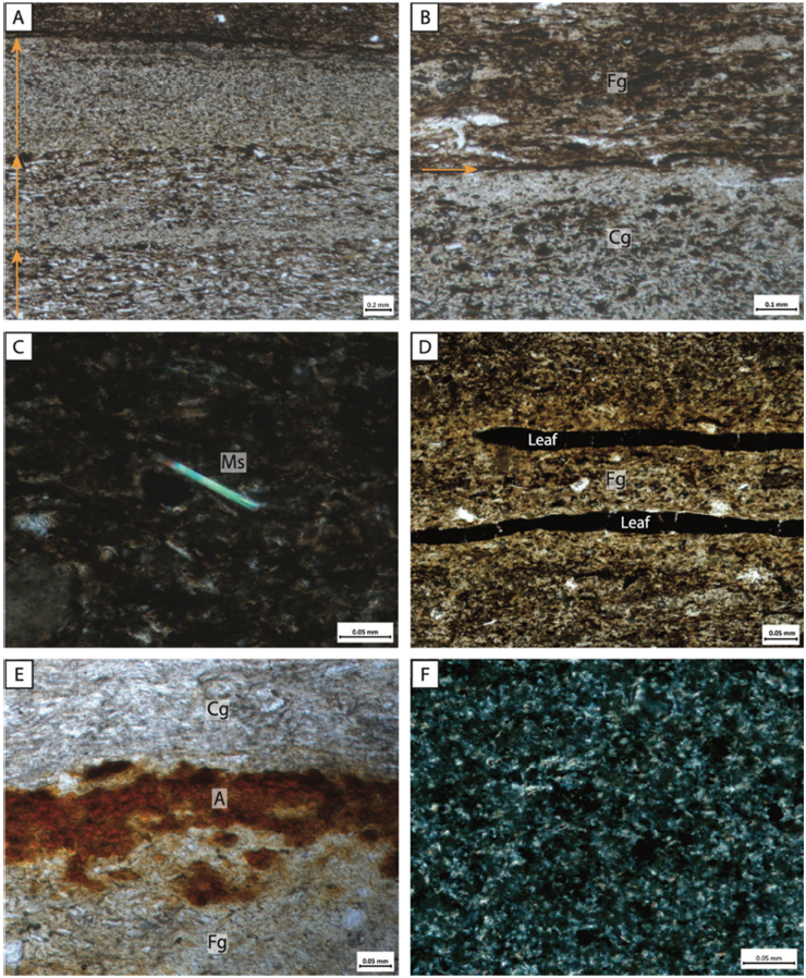
The rover discovered that the dunes were covered by two very different types of sand, one light and one dark, with the dark sand overlying the lighter dunes, implying a second generation of deposition. The barchan dunes are composed of the lighter sand, and are 15-30 m long and 3-10 m wide. The darker sand matches the surrounding soils, and forms longitudinal dunes and ridges running over the barchans, most commonly at northwest orientated longitudinal dunes crossing the western flank of the barchan. These longitudinal dunes appear more recent, and are likely to have formed under the current modern conditions.

Exploration route of Zhurong Rover and cracks on bright sand dunes. (A) Map of the exploration route of Zhurong from May to September 2021. The HiRIC photo (0.7-m resolution) was taken by the Tianwen-1 orbiter. Dunes 1 to 4, marked by white rectangles, were measured in situ on Sols 45, 64, 92, and 99, respectively. (B) Panorama mosaics acquired by Zhurong Rover's Navigation and Terrain Camera of longitudinal dunes on barchan Dune 2, with white rectangles indicating positions of the cracks. (C) and (D) Cracks developed on the southwestern slope of longitudinal dune on the western wing of Dune 2, with a white arrow pointing to one of the cracks. (E) Panorama mosaics acquired by Navigation and Terrain Camera of barchan Dune 3, with white rectangles indicating positions of the cracks. (F) Cracks on the northern slope of Dune 3. Qin et al. (2023).

Close examination of the surface of these dunes shows more that one form of cementation holding the particles together, with a continuous crust having formed on the light dues and the particles of the darker ridges held together in agglomerated clusters. Examination of the agglomerated particles suggests the presence of hydrated sulphates, hydrated silica (particularly opal), iron oxide minerals, and possibly chlorides. The hydrated sulphates and hydrated silica are most likely to be forming the cements holding these particles together.

Water traces on bright sand dunes. (A) Topographic contour map of the environs where the trace is located. The coordinate system is east-north-up local Cartesian coordinate, and the origin is that of the rover coordinate system. The background digital orthophoto map photo was taken by the Navigation and Terrain Camera. (B) Multispectral Camera bird’s-eye-view photo showing a strip-like trace and a likely water-soaked fragmented soil block. (C) Enlarged photo showing polygonal cracks and bright polygonal ridges. (D) Enlarged photo showing circular region with the strip-like trace as a part. (E) Navigation and Terrain Camera three-dimensional image of an interdune depression between two dark longitudinal dunes. (F) A cross section of the dune along the profile of the white dash line in (E). Qin et al. (2023).

Compositionally, both the light and dark sands have high iron and magnesium contents, although silica remains the most abundant material, comprising between about 52% and about 90% of all samples. Oxides make up about 15% by weight of the light sand and about 10% by weight of the dark sand. The instrumentation used is known to be incapable of detecting volatile elements such as sulphur, chlorine, and phosphorus, as well as hydrogen and hydroxide ions.

Images showing features of agglomerates and crust on the bright sand and dark sand surfaces. (a), (d) Panorama mosaics of Dunes 1 and 3 acquired by the Navigation and Terrain Camera, where white crosses denote the target positions of the laser-induced breakdown spectrometer . (b, c) The Multispectral Camera images (band centered at 699.2 nm, with a Full Width Half Maximum of 14.8 nm) of dark sand and bright sand regions denoted by the white boxes in the photo in (a). (e) The Multispectral Camera image located at the white box in the photo in (d). The upper side of the image is the dark sand region, and the lower side is the bright sand region. For (b), (c), (e), the imaging distance are 2.67m-2.81m, 2.21m-2.28m and 3.15m-3.39m, respectively and the maximum resolutions are 0.42mm, 0.34mm and 0.51mm, respectively. Qin et al. (2023).

The second and third dunes encountered are covered with polygonal cracks, although these are seen only on the underlying bright sand dunes, not the darker sand ridges running across them. The polygons formed by the cracks have an average area of 55.2 cm², and an average side length of 4.8 cm, far smaller than cracks previously observed on Mars by remote sensing. Assuming that the cracks have a depth to width ratio of between 1/3 and 1.4, this would equate to a depth of 1.25-1.7 cm. The majority of the polygons are pentagons, though they range from triangular to heptagonal in shape. The average internal angle of the polygons is 120°, and intersections between cracks are typically Y-shaped.

The MI images of bright sand and dark sand. (a), (d) Panorama mosaics of Dunes 2 and 3 acquired by Navigation and Terrain Camera. (b), (c) The MI images before and after ablation by e laser-induced breakdown spectrometer at the marked target (cross) on the dark sand surface of a longitudinal ridge on the western flank of Dune 2. The image size is 1024 pixel × 1024 pixel. (e), (f) The MI images before and after ablation by e laser-induced breakdown spectrometer at the marked target (cross) on the bright sand surface of Dune 3. The yellow dashed ellipse encircles the e laser-induced breakdown spectrometer crater. (g) The quartzite used in the laboratory experiment. (h) The MI image of the rock surface lasered by the laser-induced breakdown spectrometer. (i) The MI image of onboard Nontronite calibration target after probing with the laser-induced breakdown spectrometer obtained on Sol 58. The red arrow points to the crater created by laser-induced breakdown spectrometer laser ablation. Qin et al. (2023).

A light-toned, strip-like trace, over 40 cm long and about 1.5 cm wide was observed within the interdune depression of the second barchan dune. This ran along the lowest part of the trough depression, and separates light and dark bands of sand, with a dark sand slope to the north and a light sand slope to the south, with abundant polygonal cracks. The shape of this trace appears to be exactly what would be expected by pooled water, should this be able to exist here, and the underlying crust be impermeable to water.

Based upon the superposition of the features, Qin et al. conclude that the light-coloured barchan dunes were formed first, then became encrusted with sulphates, and possibly chlorides, during a more humid climatic phase. 

In order to determine the age of these dunes, Qin et al. looked at the density of craters on the land-surface they form part of (the rate at which asteroids randomly impact Mars is considered to be approximately constant, so that parts of the Martian surface can be dated by the density of impact craters), concluding that this surface was between 400 000 and 1.4 million years old. 

The polygonal cracks which have formed on the surface of some of these cracks are believed to have been caused by a loss of moisture, either through drying or desiccation, with the dark, longitudinal dunes forming after this, and finally the sand in the longitudinal dunes becoming agglutinated into clumps. The cementing of the sands requires a liquid or gas which was able to fill the pore spaces between them, then transform into a solid state. Such substances would include carbon dioxide gas turning into dry ice, liquid water freezing into ice, or various salts and other hydrated chemicals precipitating out of solution as the water in which they were dissolved evaporates. The conditions around the Zhurong landing site make the formation of dry ice and/or water ice highly improbable, and both of these would be detectable by the laser-induced breakdown spectrometer on the Zhurong Lander, which has found no evidence of their presence. However, hydrous sulfates, opaline silica, ferric oxides, and probably chlorides, have bee detected, and this mixture would provide a suitable cement for the sand grains.

The formation of a cement from a mixture of salts and hydrated minerals requires the presence of liquid water. This could have originated from rain, snow, or frost, or have upwelled from a subterranean source, although the evaporation of groundwater drawn upwards by capillary action seems unlikely, as there are cracked evaporation surfaces on the raised dunes, but not the surrounding flatlands, which makes the precipitation of water, either as rain or frost/snow which then thawed before evaporation, the most likely explanation.

The saturated vapor pressure (point at which the atmosphere can hold no more evaporated water, and it begins to precipitate out) is unrelated to the atmospheric pressure, although the temperature must be above 0°C for liquid rain to fall. At 0°C on Mars the saturated vapor pressure would be 611 pascals, while the atmospheric pressure observed on Mars by the Zhurong Lander  is between 786 and 834 pascals, meaning that the atmosphere would need to be about 72% water for rain to fall. Since the modern Martian atmosphere is about 95% carbon dioxide, liquid precipitation on Mars is currently impossible.

Several different landers have now taken atmospheric readings on Mars, giving a range of surface temperatures between -105°C and -5°C, a range of atmospheric pressures between 683 and 849 pascals, and a vapor pressure of 0.27 pascals. Under these conditions, the frost point (point at which the temperature drops so low that water absorbed into the atmosphere precipitates out as frost) would be about -74°C, which means frost would be possible at the Zhurong landing area. More widely, it is assumed that frost and snow are relatively common on Mars.

Mixing water ice, from frost or snow, with salts could potentially lead to its melting point being lowered sufficiently for highly saline liquid water to form. Any subsequent raise in temperature could subsequently lead to water evaporation, with seasonal or even daily cycles of frost formation, melting, and evaporation enabling the formation of cements.

The temperature on Mars is thought to rise rapidly between 5.00 and 6.00 am, local true solar time, providing an interval in which frost can sublimate, and potentially also in which it could melt and then evaporate in a hyper-saline environment. This happens seasonally, with steeper rises and higher temperatures achieved in local summer.

Map showing the number of days (noted on contour lines in terms of sols) during a Martian year and locations where the ground temperature is exceeds 0˚C. Contour intervals are 40 sols. The Zhurong landing site marked with a red star. Qin et al. (2023).

The orbital obliquity of Mars (i.e. the angle at which it is turned to the Sun, which determines the severity of the seasons) is thought to have been equal to or greater than it is now throughout the past 1.4 million years, which would mean that the climate of Mars has been comparable to or more humid than Today throughout this interval. This would imply that the formation of liquid water at low latitudes on Mars has remained at least as possible as it is today over this period.

Such a process of repeatedly forming hypersaline solutions would facilitate the dissolution of silica from sand grains to form opal, as well as attacking other minerals, enabling hydrated sulphates and iron oxides to form.

The polygonal cracks on the surface Mars are also almost certainly the result of either freeze-thaw thermal contraction or desiccation, in response to seasonal or daily changers in temperature, with their general shape suggesting the later is more likely. Meteorite impact effects and carbon dioxide freeze/sublimate cycles have been suggested as an origin for similar cracks elsewhere on Mats, but there are no signs of any meteor impacts large enough to have caused these cracks near the Zhurong landing site, and carbon dioxide is unable to freeze out of the Martian atmosphere this far from the Martian poles.

Qin et al.'s study is the first small-scale study of such cracks at low latitudes on Mars. They believe that these features are almost certainly the result of desiccation, but cannot rule out an alternative hypothesis, in which the cracks are formed by the freezing of hypersaline water, causing cracks to form in the crust under tensile stress. 

All of the features seen in the Zhurong landing area point towards the presence of saline water, providing evidence that liquid water can form at low latitudes on Mars. Qin et al. propose that water accumulated on top of the dunes as frost or snow after the atmospheric temperature dropped below the frost point, then melted due to a combination of rising temperatures and contact with salt within the sands. which would in turn facilitate the formation of hydrated silica (opal) and iron oxides. This water would then evaporate away, at fairly low temperatures due to the low atmospheric pressure on Mars, leaving the salts to precipitate out and form a cement between the sand grains, forming cracks on the dune surface as they dried out. This cycle would likely repeat numerous times.

If this hypothesis is correct, then it suggests that the amount of liquid water available on the surface of Mars in the recent past is considerably higher that previously suspected. It has previously been suggested that transient films of water might have formed on the surface of rocks in the recent past due to acid weathering, and that small amounts of water might have formed duricrusts and rock surface coatings over geological timescales. The situation at the Zhurong landing site appears quite different, with apparently mobile sands unlikely to have become cemented together by any process operating on a geological timescale. Rather this appears to be the result of an evaporative process operating over a relatively short period. less than 1.4 million years ago, and possibly less than 400 000 years ago.

This recent presence of water at 'tropical' latitudes on Mars becomes less unreasonable when it is remembered that Mars is thought to have undergone a significant change in the obliquity of its orbit about 5 million years ago, and only to have reached its current, low-obliquity orbital configuration about 3 million years ago. This may suggest that the thick ice caps present at the current Martian poles are a relatively modern feature, a result of a fairly recent transfer of water from lower latitudes, something which may well have still being occurring 1.4 million years ago. This provides further support for the theory that high-obliquity excursions in the Martian orbit might well have provided enough water for gully formation. Thus the presence of sufficient saline water at low latitudes on Mars for evaporite formation in the recent past is in fact in accord with our current understanding of the planet's recent geological past.

See also...

Follow Sciency Thoughts on Facebook.

Follow Sciency Thoughts on Twitter.


Monday, 9 August 2021

Using accurate dating to understand the sedimentary environment in the Clarkia Palaeolake of northern Idaho.

The Clarkia Palaeolake in northern Idaho formed when lava flows from the Colombia River Basalts blocked a steep-sided valley, damming the proto–Saint Maries River. The resultant lake contained a sedimentary environment in which were preserved an exquisite fossil biota, along with biomolecules, and isotope signals, which has been studied by scientists for almost five decades. Despite this attention, dating the Clarkia Palaeolake has proven elusive, due to a lack of direct radiometric, which means we neither fully understand the exact age of the deposits, nor the rates of sedimentation in the lake where they were laid down. Based upon the Plant remains found there, the Clarkia Palaeolake deposits are thought to be Early to Middle Miocene in age, with ash layers present that are thought to be correlatable to other ash layers in the Pacific Northwest for which dates have been established, making the deposits between 16 and 15.4 million years old. This correlates with the Miocene Climatic Optimum, a global warm period which is known to have had high atmospheric carbon dioxide levels, believed to be linked to outgassing from the Colombia River Basalts. The Clarkia Palaeolake sequence is a laminated sequence of beds, but it is unclear if these are the result of storm events or seasonal variation.

If it were possible to develop an accurate model of sedimentation rates in the Clarkia Palaeolake, combined with radiometric dating of the volcanic ash layers present, then this could be used to understand the wider environment of the Miocene Colombia Plateau, and the relationships between climate, volcanism, and sedimentation there, and potentially provide a model for understanding the climate and carbon cycle of the warmest part of the Neogene Period, as well as precise dating for, and a better understanding of the conditions that led to the formation of the Clarkia Palaeolake fossil Lagerstätte.

In a paper published in the journal Geology on 15 April 2021, Daianne Höfig and Yi Ge Zhang of the Department of Oceanography at Texas A&M University, Liviu Giosan of the Woods Hole Oceanographic Institution, Qin Leng, Jiaqi Liang, and Mengxiao Wu of the Laboratory for Terrestrial Environments at Bryant University, Brent Miller of the Department of Geology and Geophysics at Texas A&M University, and Hong Yang, also ot the Laboratory for Terrestrial Environments at Bryant University, present uranium-lead ages for ash layers present at P-33, the type locality for the Clarkia Palaeolake deposits, combined with micro–X-ray fluorescence and spectral analysis of elemental distribution of the laminated deposits, enabling them to calculate the annual- to centennial-scale sedimentation rates during the Miocene Climatic Optimum. 

Höfig et al. were able to obtain uranium-lead dates from zircons from ash layers at the P-33 site. Zircons are minerals formed by the crystallisation of cooling igneous melts. Whenthey  form they often contain trace amounts of uranium, which decays into (amongst other things) lead at a known rate. Since lead will not have been present in the original crystal, it is possible to calculate the age of a zircon crystal from the ratio between these elements. Sedimentation rates were then determined by detecting changes in the grain-size and elemental distribution along with the laminated beds.

 
(A) Location of the Clarkia deposit (yellow star) in Idaho, USA. CRBG, Columbia River Basalt Group; WA, Washington; OR, Oregon; ID, Idaho. (B) Topographic elevation model of Clarkia Palaeolake during middle Miocene (area about 126 km²). (C) Stratigraphic profile of site P-33 at the Clarkia deposit in Idaho, USA. Höfig et al. (2021).

Zircon dates obtained from the tephra (volcanic) layers at P-33 yielded dates ranging from 74.0 to 2533.5 million years (Unit 2C), 14.0 to 2704.5 million years (Unit 4), and 15.07 to 1914.7 million years (Unit 5B);the presence of much older zircons is not a surprise, as these crystals can survive passing through subduction zones and then being re-erupted. Using only Miocene zircons produced mean ages of 15.42 and 15.65 for Units 4 and 5B. This appears to show that Unit 5B is older than Unit 4, which it overlies; however, the entire sequence is thought to have been deposited in less than 1000 years, so Höfig et al. are only looking for an average age for the entire sequence, which is calculated at 15.78 million years, in order to place it in context with the Colombia River Basalt Group.

 
Selected images of zircon grains found in the ash layers of Site P-33. (A) Cathodoluminescence images of Miocene and Oligocene zircon grains of Unit 4 sample. (B) Oligocene zircon population of Unit 5B. C) Miocene zircon population of Unit 5B. (D) Detrital zircon grains of Unit 2C. (E) Detrital zircon grains of Unit 4. Höfig et al. (2021).

Volcanic glass shards from Unit 4 have previously shown to have similar chemical signatures to material from the Cold Springs tuff in Nevada, which has been dated to between 15.85 and 15.50 million years old. There is also a possible connection between the Unit 2C and the Bully Creek Formation’s tuff in Oregon, which has been dated to 15.66 million years. An age of 15.78 million years is also consistent with the calculated ages of the palaeobotanical material from the Clarkia Palaeolake sequence.

Excluding the ash layers, the sediments at P-33 are made up of laminations of fining-upward couplets, with chemical and mineral compositions, grain-size structures, and fossil contents which strongly suggest an annual cycle. These laminations show alternating light, coarse-grained, fossil-barren layers, interpreted as having been laid down in spring and summer, when high rainfall carried much sedimentary material into the lake, and dark, fine-grained, fossil-rich layers, interpreted being laid down in autumn and winter, when finer particles had time to settle out of the water column, and plants were shedding leaves abundantly; fossil leaves are only found in these finer, darker layers. The uppermost layers of the sequence are more oxidised than those below, and produce less fossils.

 
Selected microphotographs of textural and mineralogical features found in the units of Site P-33. (A) Varve couplets formed by finning-up cycles, which are represented by arrows in the image (plane-polarised light).( B) Contact between the dark, fine-grained layer (Fg) and light, coarse-grained layer (Cg). These layers vary in grain-size and proportions of detrital quartz, mica, opaque minerals, epidote, zircon, and apatite (plane-polarised light). C) Detrital muscovite (Ms) grain is a common occurrence in the varved-sediments of the unoxidized zone (cross-polarized light). D) Fossil leaves (Leaf) distributed in the dark, fine-grained layer (Fg) (plane-polarised light). E) Iron-alteration product (A) percolating the contact between the dark, fine-grained layer (Fg) and light, coarse-grained layer (Cg) in the Unit 5A. This unit contains quartz, mica, and opaque minerals percolated with iron alteration products. (plane-polarised light). F) At Site P-33 the ashfall layers present ultra-fine-grain size. The matrix is formed by glass shards, quartz, and muscovite and rare accessory phases (cross-polarized light). Höfig et al. (2021).

A spectral analysis of element distributions within these bedding planes revealed a similar pattern, with rhythmic variations which match the grain-size distribution; the laminae dominated by sand-sized particles are enriched in (heavy) titanium and zirconium minerals, while the other layers are dominated by potassium and rubidium minerals, typical of clays and micas. The fine-grained, fossil-rich layers were also found to be rich in organic material. This pattern of changes occurs throughout the sequence, typically happening every 10 mm in the oxidised zone at the top of the sequence, and every 5 mm throughout the rest of the sequence.

 
Spectral analysis of Unit 2D. (A) Frequency analysis of Colour. Organic content detected by Compton and Rayleigh counts (Inc/Coh), potassium/titanium (K/Ti) and zirconium/rubidium (Zr/Rb) element ratios show depositional cycles at every 9.64-14.64 mm in Unit 2D. All data are detrended and filtered using bandpass. Bars represent the sedimentation cycles detected by each ratio. (B) Signals of depositional cycles stand out above the 95% confidence interval (CI) in the power spectra. Arrows represent the most dominant depositional signal. (D) Fast Fourier Transform processing also demonstrates the frequency of the strongest depositional signal (light-coloured bands). Höfig et al. (2021).

The Clarkia Palaeolake fossil assemblage is dominated by the leaves of deciduous Plants, thought to be indicative of a warm temperate environment with strong seasonality and moderate rainfall. This again ties in with a climatic regime where there were strong seasonal variations in sediment deposition, with the presence of leaf fossils in a laminated environment without bioturbation would appear to indicate an anoxic lake-bottom environment.

An understanding of these laminated beds is essential for the reconstruction of depositional environment at Clarkia Palaeolake. Assuming that depositional rates are constant through transitional Unit 3, and that the ash-beds were laid down more-or-less instantly, Höfig et al. calculate that the roughly 7.5 m section at site P-33 was laid down over approximately 840 years, at the end of the primary phase of Columbia River Basalt Group eruptions. The uranium-lead dates obtained from the volcanic ash layers are not quite accurate enough to calibrate this model, but do help to place the palaeolake within the overall temporal framework for the Colombia River Basalt eruptions. The age model developed also helps to understand the lake's evolutionary history, and the exceptional preservation seen in these deposits. 

 
(A) Proposed age model for Clarkia Palaeolake (Idaho, USA). Varve years were determined using the average values of sedimentation rates (vertical lines within column), each unit’s thickness, and outcrop height. (B) Probability density diagrams of uranium-lead zircon ages (laser ablation–inductively coupled plasma–mass spectrometry, LA-ICP-MS) from Units 2C, 4, and 5B at Site P-33. ID-TIMS, isotope dilution thermal ionization mass spectrometry. Höfig et al. (2021).

Höfig et al. favour a seasonally fluctuating climate as an origin of the laminated beds over a storm-induced origin due to the tight coupling between changes in grain size and fossil abundance. The presence of numerous leaf fossils in the lamellae interpreted as having been laid down in autumn is consistent with a seasonal deposition pattern. Storm events can sometimes cause high sedimentation rates, but it is unlikely that repeated events could create laminar stratification over such a long time period without any storm-induced turbulence affecting the regular pattern of deposition.

The rapid deposition and burial of ancient organisms in laminated beds in ancient lakes is an important pathway for the deposition of organic fossils. The sedimentation rate seen in the Clarkia Palaeolake during the time period when the deposits were being laid down in an anoxic environment, the sedimentation rate was about 12 mm per year, exceptionally high for this type of setting, something which prevented the decay of organic material, and allowed the preservation of tissue structures and biomolecules. At the upper end of the sequence, a shift in the deposition regime caused the lake to shallow rapidly, ending the stratification regime, as the waters became polymictic (i.e. active water circulation reached the bottom at all times of year), resulting in a much lower sedimentation rate (about 6 mm per year), with deposits laid down in fully oxygenated waters. This still enabled the preservation of leaf-impressions, but led to a disappearance of biomolecules in the sequence. 

 
Evolution model of the Clarkia deposit (Idaho, USA) at site P-33. In the open-lake phase, during autumn and winter, leaves shed from surrounding trees are deposited and preserved in dark, fine-grained layers (A). These layers were interleaved with fossil-barren, coarse-grained layers deposited during spring and summer (B). As the drainage system changed (Unit 3), likely by rupture of a basalt dam holding the lake reservoir, the chemocline collapsed, leading to shallow and oxidised environment with reduced depositional rates (C). Höfig et al. (2021).

Höfig et al.'s uranium-lead zircon ages suggest that the Clarkia Palaeolake deposits were being laid down at the same time as the Priest Rapids Member from the Wanapum Basalt of the Columbia River Basalt Group (about 15.895 million years ago), which was formed after the peak of the eruption. The Columbia River Basalt Group produced about 12 175 km³ of basalt and released about 240-280 million kilotonnes of carbon into the atmosphere. This event it thought to be closely related to the fluctuations in atmospheric carbon dioxide known to have occurred during the Miocene, and a better constrained date for the Clarkia Palaeolake sequence has the potential to help us understand the atmospheric and climatic changes of this time. 

See also...


Online courses in Palaeontology. 

Follow Sciency Thoughts on Facebook.

Follow Sciency Thoughts on Twitter


Friday, 4 June 2021

Understanding the role of sediment-gravity flows in the formation of the Cambrian Burgess Shale Lagerstätte.

The fossil record has been used to reconstruct a history of the evolution of life on Earth, but itself preserves a rather incomplete record. Almost all fossils are of biomineralised or other hard tissues, with only rare sites, known as Konservat Lagerstätten, preserving soft tissues or the bodies of organisms which lack hard tissues. Estimates of the preservation potential of modern organisms suggest that 30% of marine megafuana, and 80% of megafauna overall, would leave no fossil record in normal deposits. Much of our understanding of the emergence of modern Animals comes from Cambrian Konservat Lagerstätten, such as the Burgess Shale, where it is estimated that 86% of the preserved fauna would not be preserved under normal conditions. This makes understanding the processes which led to the creation of these deposits particularlt important. It is often assumed that the Burgess Shale represents the near-faithful preservation of an intact biological community, and these fossils have been used to reconstruct food webs and community structures, but it is unclear whether the conditions which led to the preservation of these fossils did indeed preserve a high fidelity impression of a living community, or created biases which we have not detected and have worked into our understanding of how these ancient communities worked, and thus how modern communities developed from those early, Cambrian examples.

The preservation of soft tissues in fossils is rare, and thus not always as readily understood by palaeontologists as the preservation of more familiar hard tissues. Studies of the decay of modern organisms can help palaeontologists understand these preserved soft tissue fossils, but only a limited number of such studies have ever been undertaken. In particular, there are very few studies of the post-mortem transportation of soft bodied organisms, and how this effects the preservation process. 

The Burgess Shale Lagerstätte is considered to be one of the most important fossil faunas known, producing a large range of soft bodied organisms from an outer shelf Middle Cambrian environment. Understanding rhe mechanisms that led organisms to be preserved here is a key to understanding the biodiversity of the original ecosystem, as well as those of the forty plus other Cambrian sites around the world which show 'Burgess Shale-type preservation'. However, there has been a long-standing debate about the role of sediment transportation in the preservation of the Burgiss Shale Fauna, with the sediments that host the fossils originally diagnosed as having been produced in dilute turbidity currents, in which organisms were transported and then buried, then to have been in situ organisms which were buried by the turbidites. More recently, the deposits have been re-interpreted to be mud-rich slurry flows, an interpretation which, if right, would have profound implications for any soft bodied organism caught up in them.

In a paper published in the journal Communications Earth & Environment on 2 June 2021, Orla Bath Enright of the School of the Environment, Geography, and Geosciences at the University of Portsmouth, and the Institute of Earth Sciences at the University of Lausanne, Nicholas Minter, also of the School of the Environment, Geography, and Geosciences at the University of Portsmouth, Esther Sumner of the National Oceanography Centre at the University of Southampton, and Gabriela Mángano and Luis Buatois of the Department of Geological Sciences at the University of Saskatchewan, present the results of a study which used flume experiments to understand how transportation would impact the degradation of samples of the King Ragworm, Alitta virens, a modern marine species lacking hard tissues.

Field observations of the Burgess Shale exposure at Walcott Quary in British Colombia revealed that the deposits are made up of a series of silt and clay beds, with 'floating' quartz grains which average 100–500 μm in size, but can reach up to 1000 μm. These beds tend to have scoured bases, and structures such as parallel laminations, which are considered to be indicative of sediment transport. Bath Enright et al. interpret these structures as having been laid down by transitional cohesive flows, with both turbulent and laminar characteristics.

Bath Enright et al. next developed an index of degradation for Alitta virens, using specimens decayed for 0, 24, or 48 hours, and then subjected to conditions similar to those they interpret for the deposition of the Burgess Shale in a flume tank, for 25, 225, or 900 minutes. As a control measure, specimens were subjected to static decay for similar periods of time. Specimens that were partially decayed prior to transport produced a variety of results, ranging from whole, but shrivelled, to an unsupported gut with fluid escape and a general flattening of the body. The specimens tended to decay more rapidly at their posterior ends and mid-section; pre-decayed and then transported specimens tended to be more damaged towards their posterior ends. 

Next, Bath Enright et al. examined 197 specimens of Polychaete Worms from the Burgess Shale, 154 specimens of Burgessochaeta, and 43 specimens of Canadia. Very few of these showed any sign of degradation, and few of those that did showed little preference in where this occurred, although in these the preference was for the posterior to be more decayed.

 
Increasing states of Polychaete degradation. Alitta virens (right) and comparable states in the fossil, Burgessochaeta (left). (A) State 1-complete Polychaete, entire body segment intact (ROM–64913). (B) State 2-damage towards the mid-section and posterior transforms into tangled remains caused by the combination of transport and decay. The body remains intact as one segment (ROM–64916). (C) State 3-remains of the trunk and setae. The body structure has deteriorated significantly (ROM–64914). (D) State 4-remains of loose setae are attached to minute segments of cuticle and jaw elements only are recovered (ROM–64915). Bath Enright et al. (2021).

Based upon the analysis of the flume tank specimens, and comparison to specimens from Walcott Quarry, Bath Enright et al. conclude that the specimens of the Burgess Shale could have been transported in quasi-laminar flows for more than 20 km before being burried. This long distance preservation in quasi-laminar flows implied in this is in contrast to the situation seen in turbulent flows, which are more widely studied, and in which the amount of damage seen tends to increase with the distance of transport. However, Bath Enright et al. also note that this is not the case for specimens heavily decayed before transportation.

From these observations, Bath Enright et al. conclude that the specimens of the Burgess Shale were mostly un-decayed before being caught in the flows. Many of the Burgess Shale Polychaetes are compressed, but have no preferred orientation, and are typically found within the beds, rather than at their tops or bottoms. This suggests that they were transported within the flow, rather than being buried by it. At the end of Bath Enright et al.'s experiments, the sediments remained in a soupy state for some time, and living Worms were rapidly able to escape. Assuming the same applied at in the Burgess Shale, then any Worms remaining in the sediment must have been dead. Interpretation of the oxidation state of the Burgess Shale is complex, but it has been suggested that the oxic/anoxic boundary happened at the sediment surface, and the deposits are free of signs of burrowing or other bioturbation that would be expected if Worms were living in the sediment.


Schematic flow reconstruction for the Walcott Quarry in the Burgess Shale. (A) Schematic Representation in which the laminar plug extends towards the base of the flow and changes to a transitional plug regime. A turbulent cloud of sediment is suspended in the water column above the plug flow. The soft-bodied organisms (labelled 1, 2, and 3) have been picked up along the flow path, potentially kilometres apart from one another. (B) Bed A from the Greater Phyllopod Bed of the Walcott Quarry. (C) Graphic log showing Bed A; soft-bodied organisms (1, 2, and 3) from the flow type above (A) will become mixed in the deposit. (D) Thin-section scan from Bed A showing parallel laminae, erosive, scoured bases, and 'floating' quartz grains (Q). White arrows indicate transitional cohesive flow deposits. Bath Enright et al. (2021).

Burgess Shale-type lagerstätten are traditionally viewed as ‘windows’ into the biology and ecology of past life and are used to reconstruct in-life communities. However, Bath Enright et al.'s  study casts doubt on the validity of this, suggesting that the sediments present may have been transported very long distances, potentially collecting organisms from a variety of habitats before finally settling. In particular the Cambrian Chengjiang and Qingjiang biotas of China, and Upper Ordovician Beecher’s Trilobite Bed of the USA are widely interpreted to been emplaced by flows, and might therefore also have interpreted organisms from multiple environments. 

Konservat Lagerstätten provide us with a great deal of information about past life, due to their unique preservation of soft tissues and soft bodied organisms. These deposits tell us a great deal of information about the anatomy of long dead organisms, and have helped us to understand the origins of many living groups of organisms. However, Bath Enright et al. caution against attempts to reconstruct ancient biological communities based upon these deposits, without clear indication that the fossils have been preserved in their life-environment.

See also...


Online courses in Palaeontology. 

Follow Sciency Thoughts on Facebook.

Follow Sciency Thoughts on Twitter