Showing posts with label Sahara Desert. Show all posts

Sunday, 25 February 2024

Looking for the Chinguetti Meteorite.

In 1916 a young French army officer called Captain Gaston Ripert reported being taken to see a giant meteorite in the Mauritanian desert, south of Chinguetti. The story is a strange one, with Ripert claiming he was taken blindfolded, at night, on a ten hour Camel ride into the desert, where he observed a huge iron structure 100 m long and 40 m wide, recovering a smaller, 4.5 kg meteorite from its surface. Shortly after returning to Chinguetti, where he was commander of the local Camel corps, Ripert reported that his guide, a local chief, was poisoned, leaving him unable to relocate the site.

The eccentric nature of this story led many people to dismiss it out of hand. It was not unusual for western travellers of the time to make up tales of wild adventure; some even paid ghostwriters to create particularly entertaining tales. However, officers in colonial armies were supposed to refrain from such nonsense, and some aspects of Ripert's story were hard to rectify with the story being complete fiction. 

During the past century a number of expeditions have sought to locate Ripert's meteorite, with the first in 1924, although by this time Ripert was stationed in Cameroon, and could only be communicated with by letters. This meant that the early searches concentrated on the area to the southwest of Chinguetti, although Ripert later clarified that the area he was taken to was probably to the southeast. The French naturalist and explorer Théodore Monod mounted a number of expeditions to find the meteorite, starting in 1934, but was unable to locate it. In the 1950s an expedition by the French army used a declinometer  (instrument for measuring magnetic declination) in a search for the meteorite, without success, and in the 1990s a team from the British TV station Channel 4 used a magnetometer during a search for the meteorite, but took only a few measurements.

Despite all this, there are a number of elements of the story suggest that it was not complete fiction, not the least of this being Ripert's willingness to talk to experts about his journey for the rest of his life. The smaller rock which Ripert recovered did prove to be a meteorite, albeit one which, when subjected to radionuclide analysis in 2001 was shown not to have been part of a larger body (radionuclides form near the surface of asteroids due to a constant bombardment by cosmic rays, but these can only penetrate a little way, so the radionuclides they form are absent from the interior of large bodies). Finally, Ripert reported observing metallic needles protruding from the large meteorite, which he tried unsuccessfully to break off, finding that they were too ductile (able to be deformed without losing toughness) for the tools he had at hand). In 2003, the American geologist and meteorite specialist William Cassidy reported similar ductile metal needles protruding from nickel-rich zones of iron meteorites, but this was clearly unknown to science in 1916.

A fragment of the smaller meteorite brought back by Gaston Ripert in the collection of the Smithsonian National Museum of Natural History. Wikimedia Commons.

In a paper published on the arXiv database at Cornell University on 21 February 2024, Robert Warren  of Salisbury in England, Stephen Warren of the Astrophysics Group at Imperial College London, and Ekaterini Protopapa of the Department of Physics at the University of Oxford, describe the results of a more recent search for the Chinguetti Meteorite, and the prospects for either discovering its existence or proving its non-existence in the future.

Warren et al. began by collating remote-sensing data covering the region from multiple sources; they are reasonably confident that other researchers will have searched Google Earth for signs of the meteorite,  but they also accessed data from other sources, including the Shuttle Radar Topography Mission, the Advanced Land Observing Satellite (ALOS), and Landsat.

Using the reasoning that the only way a 40 m high meteorite could have disappeared in the deserts of Mauritania is for it to have been covered by a sand dune, Warren et al. began by searching for a region of high dunes which could be reached from Chinguetti by Camel in under 10 hours. There are two bands of dunes close to Chinguetti; the Les Boucles field, most of which is within 20 km of the city, and the Batraz field, which is between 40 and 60 km to the southeast. Much of the intervening area is also covered by sand dunes, but these are not large enough to describe an object as that described by Ripert.

Map showing the high sand dunes, greater than 30 m height, to the south of Chinguetti. Warren et al. (2024).

Warren et al. made two trips into the desert from Chinguetta, in the company of experienced local chameliers, one lasting eleven days and one lasting six. They found that Camels typically travel at speeds of between 2.0 and 3.6 km per hour, assuming good terrain, with the maximum speed achieved by unburdened Camels being about 5.0 km per hour. 

However, even assuming that Ripert and his guide were riding Camels unburdened by anything other than themselves, it is unlikely that this maximum speed would have been achieved for 10 hours, because the primary concern of the chameliers is for the welfare of their Camels, which are not only the most important assets they own, but also their only way of getting back to safety should a problem arise. This meant that if Warren et al.'s chameliers expected a journey to take four hours, they would travel for two hours, then give the Camels a three hour break to rest and feed, before completing the journey, something they were quite inflexible about. Neither would they travel in a straight line on anything other than the flattest terrain, but instead would zig-zag to avoid taking the Camels over steps and ledges, and would never take their Camels over the tops of dunes.

Ripert himself mentioned taking several detours during his journey, which makes a journey 50 km in a straight line from Chinguetta even less plausible. However, for the sake of convenience, Warren et al. take the area within 50 km of the city as a search area. This includes the more distant Batraz Dune Field, which Warren et al. consider unlikely, although they do concede that there is a route along a dry river bey which could bring a determined Camel rider this far in 10 hours if breaks were neglected. They also rule out the area of the Les Boucles Dune Field which lies within 10 km of the city, reasoning that Ripert, who was in charge of the local Camel Corps, would have recognised a location in this area. 

A sand dune in the Les Boucles Dune Field to the south of Chinguetta. Bruno Locatelli/Google Maps.

Having defined their search area, Warren et al. then searched their dataset for dunes large enough to have covered the meteorite described by Ripert. According to Ripert's description, the northeastern side of the meteorite was already covered by a dune at the time when he visited. The area is noted for its strong, prevailing winds, which blow northeast to southwest more-or-less constantly all year round, causing sand dunes to migrate in the same direction, and Ripert stated in 1932 that he thought it possible that the meteorite would already have been covered by the dune. Taking Ripert's estimate that the meteorite was 40 m high, it would require a dune more than 40 m high to cover it.

Sand dunes in a desert do not typically stack up against one-another; instead, they are usually discrete structures, with flat spaces between them. Warren et al. identified dunes higher than 30 m high in their remote sensing dataset, in order to give an error of margin, creating a map showing dunes which meet this criterion within the two dune fields. Since dunes are unlikely to have moved more than 100  m since 1916, the meteorite, if buried, must be within 100 m of the western edge of the dune covering it. 

Since a height of 30-40 m is reached within 300-400 m of the western flank of the dunes, it would in theory be possibly for a walk along the western flank of the dunes with a magnetometer (a passive instrument that measures changes in the Earth's magnetic field), and be confident of passing within 500 m of the meteorite, a distance at which it ought to be highly detectable.

Warren et al. also not that a magnetic survey of the area has been carried out by aircraft on behalf of the Mauritanian Ministry of Petroleum Energy and Mines by the Fugro geological surveying company, using funds provided by the World Bank, and this data has subsequently been made available to teams of scientists working on other projects. With this in mind, Warren et al. wrote to the Ministry requesting access to the data, but have yet to receive an answer.

Between 13 and 17 December 2022 Warren et al. carried out a magnetometer survey of the eastern part of the Les Boucles Dune Field on foot, covering the western edges of six large dunes, based upon which they are confident that the presence of a large iron meteorite beneath these dunes can be ruled out. Based upon the time this took, they estimate that a survey of all the potential dunes would require an expedition lasting three weeks. 

See also...

Monday, 8 January 2024

Letti Desert 1: A new archaeological site associated with the ancient African Kingdom of Kerma.

The ancient Kingdom of Kerma is one of the oldest known states in Africa, emerging in the third millennium BC from the urbanisation of pastoral communities in the Selim Basin of the Third Cataract of the Nile, and persisting until 1504 BC, when it was conquered by the Egyptian Pharaoh Thutmose I. The Kermans built distinctive urban centres with monumental buildings and necropolises, although these have only been extensively studied around- the Third Cateract, with some funerary cites around the Fourth Cataract also known.

In a paper published in the journal Antiquity on 1 December 2023, Piotr Osypiński of the Institute of Archaeology and Ethnology of the Polish Academy of SciencesMarta Osypińska of the Institute of Archaeology at the University of Wrocław, Justyna Kokolus, an independent researcher from Stara Dąbrowa in Poland, Paweł Wiktorowicz, also of the Institute of Archaeology and Ethnology of the Polish Academy of Sciences, Roman Łopaciuk of the Institute of Mediterranean and Oriental Cultures of the Polish Academy of Sciences, and Amel Hassan Gismallah of the National Corporation of Antiquities and Museums in Khartoum, describe a new archaeological site associated with the Kingdom of Kerma, from the Letti Basin of the Middle Nile Valley in Northern Sudan.

Osypiński et al. identified a number of new sites on the edge of the desert in the Letti Basin, sites which would have been located in close proximity to the seasonally overflowing Nile at the time when Kerma existed. Some of these sites appear to have been extensive settlements, from which were recovered characteristic Kerman ceramic objects, Animal bones, and stone tools, as well as carrying out excavations at one site, named Letti Desert 1.

Middle part of the Nile Valley and location of site Letti Desert 1. Osypiński et al. (2023).

Radiocarbon dates recovered from organic material at Letti Desert 1 suggest that the site was occupied for about 700 years, with the oldest dates being between 2205 and 2020 BC while the youngest come from between 1618 and 1497 BC, around the time of the Egyptian conquest. 

A mud brick building with a surviving thickness of about one metre was established to have been constructed around the beginning of the second millennium BC. Neighbouring structures contained large storage vessels, and had foundations made from boulders up to 3 m in diameter. A granary area with a pavement of square stones was surrounded by post holes. Another area was interpreted to be a metal workshop, with fragments of a large melting pot, and several bronze smelts recovered. 

Architectural elements recorded in the eastern part of the Letti Desert 1 settlement, marked in red. The size of opened excavation is 5 × 5 m. Osypiński et al. (2023).

Analysis of zooarchaeological remains from the site suggests that Cattle became progressively less important over time, with Sheep replacing them as the major form of livestock. This was probably associated with the drying of the local climate and spread of desert. Cattle are known to have remained culturally important, with the rulers of Kerma being buried with Cattle bucrania (the frontal part of the skull, with the horns) in the latest stages of the civilization. However, isotopic studies of these remains suggest that these Cattle came from outside the Nile Valley, possibly from North Kordofan to the south, from where Cattle could be driven to the Letti Basin via the dry channels of Wadi el Melik and Wadi Howar.

Stone pavements in the western part of the Letti Desert 1 settlement, view from the north Osypiński et al. (2023).

See also...


Follow Sciency Thoughts on Facebook.

Follow Sciency Thoughts on Twitter


Friday, 6 May 2022

Kite-like structures in the western Sahara Desert.

Since 2010 numerous 'kite-like structures' have been discovered in the Middle East, and more recently the Libyan Sahara. These are prehistoric megastructures, interpreted to have been gigantic traps, into which Animals could be driven by hunters. The vast nature of these structures makes them almost impossible to detect from the ground, with almost all being detected from satellite imagery. Most of these structures are in remote desert regions, and to date, very few of these have been visited or investigated by archaeologists, leaving us with little idea about their age or the people who constructed them.

In a paper published in the journal Antiquity on 31 March 2022, Olivier Barge, Laetitia Balaresque, and Jean-Loup Baudoin of the Université de Lyon, Manfred Boelke, an independent researcher from Düsseldorf in Germany, and Lison Derrien of Aix-Marseille Université, report the discovery of almost 500 new kite-like structures in satellite images of the western Sahara Desert.

The majority of these newly discovered structures are located in two concentrations, one between the Hoggar Mountains and Erg Chech, in the Acedjerad and Ahnet region of southern Algeria, and a second stretching from the area between Erg Iguidi and Erg Chech in the area that marks the triple border between Algeria, Mali, and Mauritania eastwards along the Hank escarpment further into Mauritania. These structures differ in form from the Libyan structures, but share enough similarities for Barge et al. to conclude that they are also hunting structures, and were probably built by people from the same extended community.

 
The locations of kite-like structures. Olivier Barge in Barge et al. (2022).

The kite-like structures of the western Sahara typically have two long, converging walls, with a small proportion having two additional walls between these. Four different types of structure have been recognised in the area. Typa A, are the most numerous, with 163 known examples, and simply comprise a pair of long converging walls leading to a simple cell, similar to the first-discovered kite-like structures of the Negev Desert.

 
A Type A kite-like structure in Libya. Bermerkenswelt der Archäology.

The next most numerous type of structure, Type B, are the next most numerous with 139 known examples, and are similar to Type A structures, but have two walls which converge rapidly tecoming almost parallel, often bending, forming a narrow corridor ending in a cell.

 
A Type B kite-like structure in Libya. Bermerkenswelt der Archäology.
 
Type C structures, of which 110 examples are known, are similar to Type A structures, but end in several cells in a line, usually between two and seven, but with some larger examples, rather than a single cell.

 
A Type C kite-like structure in the Adrar/Tamanrasset area of Algeria. Bermerkenswelt der Archäology.
 
Finally, and least commonly, with only 20 known examples, Type D structures resemble to others, but are open at their ends, lacking any sort of cell.

A Type D kite-like structure in Libya. Bermerkenswelt der Archäology.

Additionally, a further 60 examples have been identified which are too badly preserved, or to poorly imaged, to be assigned to any of these groups. Barge et al. also note that Type D structures tend to be the largest, followed by Type B, with Types A and C often being quite small. 

 
(A) Average length of driving lines per type; (B) Histogram of the number of cells in Type C structures. Barge et al. (2022).

Type A structures were found all across the study area, while Type B structures were concentrated in the Hank region of Mauritania and the Tripolitania region of Libya. Type C structures are known only from the Acedjerad region of southern Algeria, while type D structures are found in the Hank region of Mauritania and the Jebel al Husawinah are of Libya. Barge et al. note that kite-like structures have also been recorded from the Nama Karoo of South Africa, but that these appear to be of quite different construction.

The different types of structures had different patterns of orientation, with Type C structures tending to be orientated towards the east, and Type D structures towards the southeast, presumably to capture animals during annual migrations. Type A and B structures were typically orientated to slope direction rather than compass points, with their openings downwards. This often results in structures on opposite sides of a valley pointing away from one-another.

Without proper ground investigation, it is impossible to be certain of the purpose of these structures, however their generally morphology and similarity to the V-shaped kite structures of the Negev Desert does strongly suggest that they were Animal traps, with the cells at the ends possibly representing pits. In almost all cases, the construction of the trap used local topology to hide these cells (i.e. the trap funnelled the Animals up a slope, with the final trap over the brow of the hill).

If these structures were used for hunting, then it is unclear what species they were built to target. The western Sahara today is an area of extreme aridity, with few large Anumals to hunt, but many of the kite-like structures face towards oueds (dry river beds) or other depressions thought to have once held water, so it is possible that they were built at a time when there were reliable water-sources, and Animals exploiting them, for at least part of the year. It the case, then it would suggest that the structures were built between 5000 and 9000 years ago, the last wet optimum of the Sahara, when the area is known from other evidence to have been inhabited by nomadic Humans.

See also...


Follow Sciency Thoughts on Facebook.

Follow Sciency Thoughts on Twitter.


Friday, 31 December 2021

Investigating ancient burials in western Africa.

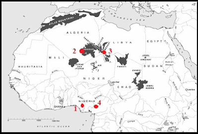
The organised disposal of the dead is considered to be an important step in the development of Human cognition, an activity driven by the needs of the living to cope with the loss of a loved one, rather than any need of the deceased. In Africa, the earliest burials appear about 90 000 years ago, and are generally of single people thought to have been buried by nomadic or semi-nomadic peoples, with notable examples at Taramsa I in Egypt (about 55 000 years old), Shum Laka in Cameroon (7100-6900 and 3300-3000 years old), Mbi-Crater, also in Cameroon (about 7790 years old), Wadi Kubbaniya in Egypt 19 000-17 000 years old), Amekni in Algeria (9000-8000 years old), Ti-n-Hanakaten, also in Algeria (about 6000 years old), and Iwo Eleru in Nigeria (16 000-11 000 years old). These are eventually replaced by the emergence of formal cemeteries, about 25 000-23 000 years ago, in which the dead are buried together at sites dedicated to the purpose, thought to be a sign of people living together in settled communities, with notable examples at Mechta el Arbi in Algeria (22 000-13 000  years old), Afalou Bou Rhummel, also in Algeria (12 450-10 500 years old), Columnata, again in Algeria (8300-7300 years old), Taforalt in Morocco (15 100-14 000 years old), and in northern Sudan (14 340-13 140 years old).

In a paper published in the Journal of Anthropological And Archaeological Sciences on 20 December 2021, Augustin Holl of the Department of Anthropology and Ethnology at Xiamen University explores the Iwo Eleru, Amekni, Ti-n-Hanakaten, and Shum Laka burial sites, and what these can tell us about the people buried there, and the people who buried them.

 
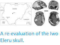
Location of the sites discussed. (1) Iwu Eleru. (2) Amekni. (3) Ti-n-Hanakaten. (4) Shum Laka. Holl (2021).

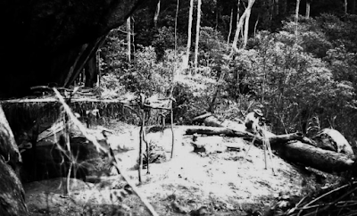
The Iwo Eleru Rock Shelter in southwestern Nigeria (modern Ondo State). The site was first excavated in the 1960s by a team led by Thurstan Shaw, revealing a Human skeleton in a tightly crouched position between two large collapsed stone slabs. The skeleton was poorly preserved, but is thought to have been a man between 35 and 45 years of age at the time of death. The teeth of Iwu Eleru Man were very badly worn, ground down to the gums in a series of great sweeping oblique curves running in different directions. Damage of this kind can be caused by certain forms of craft-working, notably basket or Reed-mat making, or by eating extremely fibrous foods, such as raw and sometime sandy fibrous tropical tubers. The body was covered by about 1.5 m of sediment, containing numerous lithic artefacts, notably quartz and chalcedony segments, borers, scrapers, trapezes, trapezoïds, points, and truncated blades. Towards the top of this sequence pottery fragments and ground stone axes appear, although there are no obvious stratigraphic breaks in these deposits.

The deposits above the burial indicate that the site continued to be used by living Humans after the burial, although probably not continuously. The site is likely to have been repeatedly used as a shelter by non-settled peoples passing through the area, perhaps seasonally, with the burial being placed there because a member of the community died while they were staying there. No grave goods were found, but the body was covered over by two large stone slabs, and possibly leaves, twigs, and tree branches, which implies some form of ritual, and a desire to protect the body from scavenging by wild Animals.

 
View of Iwo Eleru rock-shelter. Holl (2021).

The Amekni burial is in a granite boulder field to the southwest of the Ahaggar Mountains of southern Algeria. The area is known to have been inhabited by pottery-making foragers between 7000 and 6000 BC, and these are thought to be the people responsible for the burial. Three skeletons were found at this site, a woman thought to be 40-50 years old, and two children aged roughly 2-3 and 5-6, who were buried in a crouched position, and possibly wrapped in Animal skins. The woman is probably two old to have been the children's mother, though she could possibly have been their grandmother. This does not appear to have been the beginnings of an organised cemetery, but rather the burial of three members of a mobile community, and possibly the same family, who died at approximately the same time and were therefore buried in the same place.

The Ti-n-Hanakaten rock shelter is located at the junction of the Tadrart Acacus and Tassili-n-Ajjer mountains, about 150 km to the southeast of the town of Djanet. The site has a Epipalaeolithic archaeological sequence about 5 m thick, which spans about 20 000 years and records the advent of pottery in the area, as well as a scattering of Acheulean artefacts (an Old Stone Age technology, associated with Homo erectus rather than Modern Humans). The site produced a single burial, a child of uncertain age, who was buried in a tightly crouched position, wrapped in an Animal skin, within a circular pit filled with grass and straw, and sealed with a large stone slab, which had been smeared with red ochre. The Ti-n-Hanakaten burial has been dated to about 6000 years old, making it a similar age to the Amekni burial, with which it shares some similarities; in both cases children were buried in crouched positions and wrapped in Animal skins. However, the Ti-n-Hanakaten burial is more elaborate than the Amekni burial.

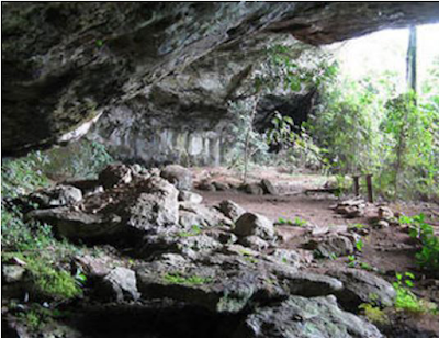
The Shum Laka rock-shelter is located in the volcanic highlands of northwestern Cameroon, at an altitude of 1600 m above sealevel, overlooking the Laka Valley. The rockshelter is located at the foot of a waterfall, and measures roughly 54 m by 25 m, with a floor surface of about 1181 m², of which 82 m² has been excavated, and an 8 m high roof.

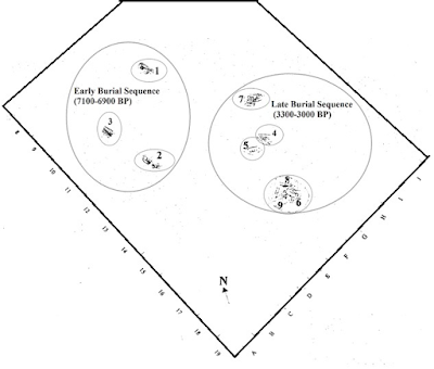
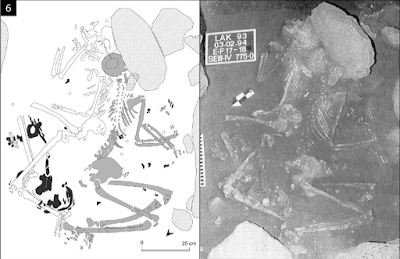
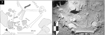
The site has yielded four distinct archaeological units, ranging in age from 32 000 to 3000 years. There are two sets of burials here, both associated with Holocene layers, the older dating from 7100-6900 years ago with four sets of remains in three burial and the younger from 3300-3000 years ago with fourteen sets of remains in nine burials. This larger clustering of burials raises the possibility that the people here might have been moving towards the organised burial of their dead in permanent cemeteries set aside for this purpose.

 
View of Shum-Laka rock-shelter. Holl (2021).

The earlier phase contains three burials at the northwest of the excavated area. The first of these is a man of about thirty with moderate osteophytosis on some vertebrae, some inflammation of the limbs, and two healed fractures, on the clavicle and left humerus, as well as dental calculus and heavy wear to the canine teeth, something which is almost certainly associated with some form of craftwork. His death appears to have been due to the cumulative effects of illness and old age, and his remains have been dated to about 7040 years ago. He was buried bout 8 m from the entrance to the cave, laid on the bedrock and covered with stones (in a similar fashion to the Iwu Elero burial), and covered by about 80 cm of sediment. The skeleton was in a sleeping position on its right side, with hands under the head, fcing towards the entrance of the shelter. 

The second early phase burial is locater 3 m south of the first, and 5 m from the entrance. It contains two sets of remains, a boy of about four years and a subadult about 15 years old, of indeterminate sex, with the child buried on top of the subadult, at the same time, in a pit surrounded by and filled with stones.

The boy has Harris lines on his bones, suggesting periods of arrested growth in his development, possibly indicating he was suffering from an infectious disease before his death. He was buried on his left side in a tightly contracted position, with his knees under his chin, facing towards the north, under about 65-95 cm of sediment, and his remains have been dated to approximately 7150 years ago.

The second skeleton has signs of an injury to the lower jaw, which caused a number of dental deformities, which possibly occurred when they were six or seven years old, as well as signs of an old injury to the left foot, which led to localised vascular disturbance. In addition to the injuries the skeleton had a hypertrophy of the supinator crest, which is an indication of regular practice with a throwing implement, such as a spear. The remains were buried in a half flexed half stretched position, the left arm stretched, the right one folded at right angle, and, like the younger child's, have been dated to 7150 years ago.

The final early stage grave appears to be a secondary grave for someone who was initially buried somewhere else. This contains a selection of limb bones, namely a right and left femur, right radius, and right fibula, all apparently from an 18-year-old male, 1.64 – 1.66 m tall. These were buried in a pit 60 cm deep, 75 cm long, and 25 cm wide, into which some Animal bones had also been deposited, although it is unclear if this association was deliberate. This individual appears to have been suffering from an unhealed ankle injury at the time of death, but was otherwise physically fit, with muscle attachments which suggest a powerful physique, and again regular practice with a spear or similar implement. These remains have been dated to 6870 years ago.

The wide range of dates obtained for these burials combined with the differences in burial style strongly suggest this was not a sign of a developing cemetery, but rather of a series of separate burials by different groups of people who moved through the area, and used the shelter temporarily, burying members of their groups who died while they were there.


Early and Late Holocene burial clusters from Shum Laka. Holl (2021).

The second group of burials are dated to between 3300 and 3000 years ago, and comprise fourteen sets of remains in nine separate burials, located at the eastern end of the excavated area. 

The first of these burials is a girl of about eight years old. The teeth of this girl suggest a series of severe health crises throughout her life beginning when she was about 6-9 months old, and continuing throughout her life. She was buried in a flexed position on her left side, facing to the north, about 7 m from the cave entrance and 25 cm deep. Her remains have been dated to about 3045 years ago.

The second of the younger phase burials is another young child, this time about four years old, and probably a girl. This individual seems to have been healthier than the first until the time of death, with some dental calculus, but no other pathologies. The body was laid on its back in a pit less than a meter from the previously described burial, and 4-5 m from the cave entrance. These remains have also been dated to about 3045 years ago.

The third of the younger phase burials contains two sets of remains, both those of adult women. This grave was placed 5 m from the rock shelter entrance, and was about 75-95 cm deep. They were placed on their sides, back-to-back, with the first woman facing to the west and the second to the east. Both sets of remains have been dated to 3300 years ago.

The first of these women was 20-30 years old and about 1.53-1.55 m tall at her time of death. She had several dental pathologies which suggest several episodes of illness or malnutrition in her childhood, with muscle attachments that suggest she was physically strong and regularly took part in repetitive physical activity.

The second woman is estimated to have been 30-50 years old at her time of death, and 1.43-1.48 m tall. Unlike the first woman, she appeared to be suffering from a number of health problems, including severe dental decay and Arthritis of the spine and lower arms, which appear to have related to her age and a lifestyle involving frequent hard labour. Despite this, she also appears to have been well muscled, and from the asymmetry of her muscle attachments, probably right handed.

 
The joint burial of two women from the younger burial phase at Shum Laka. Lipson et al. (2020).

The fourth burial of the new phase is located about 1.5 m to the north of the first, and contains 273 skeletal elements, derived from at least seven children, placed in a pit 1 m long, 60 cm wide, and 45 cm deep. This pit appears to contain a mixture of primary and secondary burials, with some of the remains showing signs of heating. The two primary internments are a boy of 5-7 years old showing signs of repeated environmental stresses in his life, and a stone arrowhead stuck in his left ilium, which appears to have been the cause of death, and another child of 10-16 years old. The remaining bones are from disarticulated skeletons, presumed to be secondary burials. These include three children aged 2-4 years, a 3-5 year old, and a 5-9 year old, most of which show pathologies that would have related to health problems in life.

This grave is confusing, and difficult to interpret, but Holl notes that there appear to have been two phases of burial within the same pit, with the two children identified as primary burials interned together, between 3180 and 3025 years ago, and the disarticulated and possibly cremated remains (which could not be dated) added later, possibly accidentaly uncovering the earlier grave in the process.

 
Burial Unit 7 (collective) showing disarticulated crania and one partially articulated post-cranial skeleton (20-30 cm below surface). Lipson et al. (2020).

The fifth of the new phase burials contains the remains of two robust adult males, aged 30-35 and 40-45 years. These remains had been cremated prior to burial, and was disarticulated and separated into three piles, the first containing cranial vault and tibia fragments, the second long bones and cranial vault fragments, and the third long bones and mandibulae fragments. These remains could not be dated, but appear to predate the third new phase burial, which overlies and partially disturbs this burial; this is a reversal of the situation in the fourth new phase burial, in which the deposition of cremated remains appears to have disturbed un-cremated remains which were buried earlier.

The final new phase burial is another set of cremated remains, this time of a single individual. In this case a high temperature appears to have been achieved during the cremation (probably about 800°C) resulting in very white and fragmentary remains, although parts of the skull, teeth, vertebrae, ribs, scapulae and clavicles, hands, sacrum, coccyx, and coxal bones, long bones, feet, and undetermined long bones could be identified, supporting the hypothesis that this was a single, intact, individual. These remains could not be dated, but again they appear to have pre-dated and been partially disturbed by, the third new-phase burial.

Although these burials represent a reasonably high number of individuals in a moderately short period of time (14 individuals in about 300 years), the differences in the ways in which they were buried, combined with the fact that some of the burials appeared to have accidentally disturbed older burials, suggests that this was still not a site being used specifically as a cemetery, but rather repeatedly chosen as a burial site by different groups of people moving through the area, and probably using the rock shelter as a temporary dwelling place.

See also...


Follow Sciency Thoughts on Facebook.

Follow Sciency Thoughts on Twitter.


Tuesday, 28 December 2021

Stone tools from Sudan's Eastern Desert.

The key areas for the migration of Hominins from Africa into Eurasian appear to have been the Eastern Sahara Desert of Egypt and Sudan and the Arabian Peninsula. Two distinct groups of Hominins appear to have used this route, Homo erectus/ergaster in the Middle Pleistocene, and Homo sapiens in the Late Pleistocene. This area appears to have undergone a considerable cultural shift around the boundary between Marine Isotope Stages 7 and 6, i.e. about 191 000 years ago, with material associate with the Early Stone Age Acheulean Tradition, which is associated with Homo erectus/ergaster, and which had dominated Africa, Europe, and Asia for about 1.5 million years, being replaced by material associated with the Sangoan Complex, which is considered to be a Early Stone Age/Middle Stone Age transitional technology that might be associated with the arrival of Early Modern Humans in the area (although the earliest known Early Modern Human remains are associated with the more advanced Levallois technology).

The Acheulean technology is largely associated with large cutting tools, such as handaxes, cleavers, picks, and choppers, worked symmetrically by removing flakes from each side, but with little use of the smaller flakes produced. The Sangoan is marked by the production smaller bifaced stone tools, with more retouching to produce finer edges, as well as a greater use of bone and antler tools. The Levallois Technology involved preparing a stone core, then chipping away flakes progressively to form a pattern resembling a Tortoise shell, with the primary objective apparently being to produce a series of small, sharp chips, which were themselves used as tools.

Sangoan assemblages are found over a wide area of Africa, with several sites in Sudan having produced them, notably Sai-8-B-11, Khor Abu Anga, and al-Jamrab. A number of site associated with the Levallois technology have also been found in northeast Africa, with the best known being Dakhleh Oasis  and Kharga Oasis Locus IV in the Egyptian Western Desert, both of which have been dated to about 220 000 years ago, and Bir Sahara East and Bir Tarfawi, also in Egypt, which have been dated to younger than 130 000 years ago.

In a paper published in the Journal of Field Archaeology on 11 November 2021, Grzegorz Michalec of the University of Wrocław, Marzena Cendrowska, also of the University of Wrocław, and of the Archeolodzy Foundation, Eric Andrieux of the University of London and Durham University, Simon Armitage, also of the University of London, and of the University of Bergen, Maciej Ehlert, again of the niversity of Wrocław, and of the Archeolodzy Foundation, Ju Yong Kim of the Korea Institute of Geoscience and Mineral Resources, Young Kwan Sohn of the Gyeongsang National University, Joanna Krupa-Kurzynowska of the Wroclaw University of Science and Technology, Piotr Moska of the Silesian University of Technology, Marcin Szmit of the Gdańsk Archaeological Museum, and Mirosław Masojć, once again of the University of Wrocław, present the results of an excavation carried out in 2019 at a site called EDAR 135 in the in the Atbara River region of Sudan's Eastern Desert. 

Acheulean remains were first recorded in the in the Atbara River region at Khor Hudi and Khashm el Girba by Anthony John Arkell in the 1940s, with subsequent exploration around Khashm el Girba by Waldemar Chmielewski in 1967 uncovering a further 26 sites yielding Acheulean and Levallois artifacts. In 2005-2008 a series of expeditions led by Ernesto Abbate revealed uncovered a 50 m thick sequence along the mid-Atbara River between Khashm el Girba and Halfa al Jadida, which produced Pleistocene faunal remains and Acheulean handaxes dated to Marine Isotope Stage 7 (243 000-191 000 years ago) and Levallois assemblages dated to between 126 000  and 92 200 years ago.

 
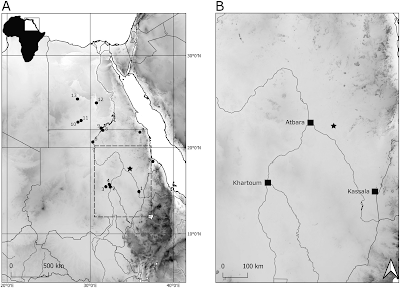
Location of Acheulean and Levallois sites in Sudan and Egypt (EDAR 135 marked with a star). (1) Khashm el Girba; (2) Khor Abu Anga; (3) Al-Jamrab; (4) Khor Shambat; (5) Hayna and Tagrada; (6) Sai Island 8-B-11; (7) Gebel Karaiweb; (8) Wadi Halfa; (9) Arkin 8; (10) Bir Sahara; (11) Bir Tarfawi; (12) Kharga Oasis; (13) Dakhla Oasis. Michalec et al. (2021).

The Eastern Desert Atbara River Project was a collaboration between the Institute of Archaeology at the University of Wrocław, the Faculty of Archaeology & Tourism at Al Neelain University, the Korea Institute of Geoscience and Mineral Resources, and the Research Institute of Natural Science of the Gyeonsang National University, which aimed to identify new Middle and Upper Pleistocene archaeological sites in a stretch of the Sudanese Eastern Desert about 70 km to the east of Atbara city, in a series of expeditions between 2016 and 2019.

The project took advantage of recent excavations carried out by gold prospectors. Gold has been excavated in Sudan since ancient times, with a recent gold rush beginning in 2008. This has been somewhat of a mixed blessing for archaeologists working in the region, on the one hand uncovering a number of new, previously unknown, archaeological deposits, but on the other damaging or destroying a number of sites completely, both new and previously known, including some which were specifically targeted for their gold artefacts.

 
EDAR 135 site. (A) Aerial photography of mining shaft complex; EDAR 135 marked with black arrow; (B) aerial photography of the EDAR 135 site; (C) eastern profile of mining shaft with marked (red dots) places of Optically Stimulated Luminescence dating samples S4 and S5 sampling places; (D) northern profile; (E) northern profile before upper level excavations; (F) removing sterile sediments above the lower horizon; and, (G) excavating lower horizon (Acheulean). Michalec et al. (2021).

The EDAR 135 site was discovered in 2017, when lithic items were discovered in the wall of a 5 m deep mining shaft. The site was cleaned up, a geological assessment made, and a series of samples collected for Optically Stimulated Luminescence dating. In 2018 the team returned to the site, to carry out further mapping and sampling. Finally, in 2019, a 5 m² trench was excavated northward of the mining shaft, by removing the overburden with hoes and pickaxes, then excavating the archaeological layers with brushes, geological picks, and small trowels, and finally sieving the excavated sediment through a 5 mm mesh.

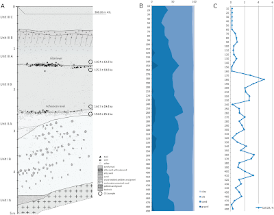
The excavated section is 5 m deep, with a base of weathered rhyolite (high silica volcanic rock), which is overlain by a sequence of sand/silt sediments with interbedded gravel and rock fragment horizons. The oldest sediments were dated to more than 391 000 years old. Artefacts were recovered from two gravel horizons, the lower dated to between 194 800 and 144 700 years ago, the upper dated to between 125 300 and 116 400 years ago.

 
Northern profile and chronology of EDAR 135. (A) Stratigraphy and two cultural horizons with Optically Stimulated Luminescence dating results; (B) results of granulometry analysis; and, (C) calcium carbonate content. Michalec et al. (2021).

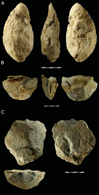
The lower tool-producing layer at EDAR 135 produced three Acheulean large cutting tools; a quartz handaxe, a partial rhyolite handaxe, which had apparently been crushed by gold mining machinery, and a rhyolite chopper.

 
Large Cutting Tools from EDAR 135: (A) handaxe, quartz; (B) basal fragment of a handaxe, rhyolite; and, (C) chopper made from a rhyolite cobble. Michalec et al. (2021).

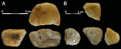
In addition to the large cutting tools, seven cores were recovered from the lower tool-bearing layer. Five of these were small cores made from quartz, all of which were heavily reduced by the removal of multiple flakes. These show signs of a number of different preparation methods being used.

 
Cores made from quartz pebbles: (A) bipolar and (B) flake core with changed orientation. Michalec (2021).

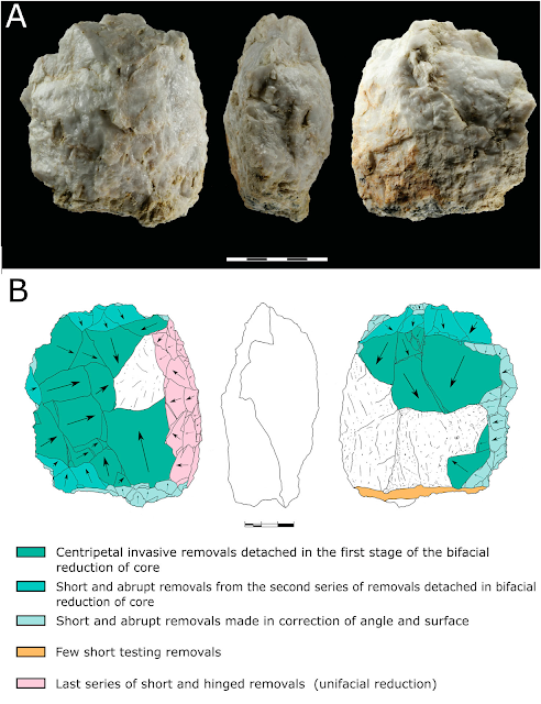
The first of the larger cores is a discoidal piece of quartz, that has a non-hierarchized structure, and shows no traces of predetermination. The maker appears to have focused on bifacial, centripetal removals, then corrected the flaking angle with a series of short removals to prepare the striking platform, and finally aimed at unifacial reduction with the natural surface of the less transformed side used as the striking platform.

 
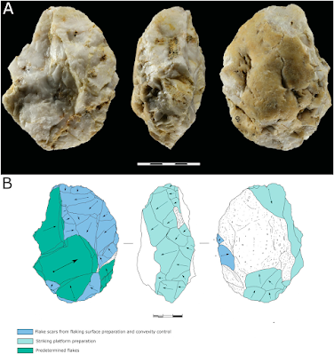
(A) Levallois core (quartz) from EDAR 135, lower horizon and (B) graphic presentation of scar pattern analysis results. Michalec et al. (2021)

The second larger core is also quartz, a prepared centripetal flake core, showing hierarchisation of structure and a high degree of preparation. The primary surface is completely decorticated by centripetal removals, while the secondary surface was used as the striking platform. This tool appears to have gone through three stages of development, firstly preparing the flaking surface by unifacial removals, with a 75–90° flaking angle, then the preparation and control of the main flaking surface, and finally the removal of invasive and long flakes.

 
(A) Discoidal core (quartz) from EDAR 135, lower horizon and (B) graphic presentation of scar pattern analysis results. Michalec et al. (2021).

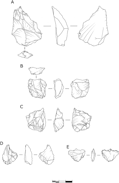
The most abundant artefacts at EDAR 135 are debitage flakes and chips (pieces removed from a larger core, which may-or-may not be intended for use as tools in themselves) and waste. This comprised 549 chips, 119 flakes, and 36 other debris items. The overwhelming majority of this material is quartz, with only 7 flakes and 11 chips made of rhyolite. In addition, there were 23 retouched tools, formed by the modification of chips after they were removed from a core to form six denticulates, four sidescrapers, two flakes with simple retouch, three notches, three perforators, two endscrapers, two combined tools with mixed retouch, and one Levallois flake.

 
Retouched tools: (A)–(B) sidescrapers and (C)–(E) perforators. (A) Rhyolite and (B)–(E) quartz. Michalec et al. (2021).

The tools in the lower tool-bearing layer at EDAR 135 follow two basic patterns of construction, the preparation of large cutting tools such as axes and choppers, fairly typical of the Acheulean technology, and the preparation of smaller tools by chipping away from a core, sometimes with subsequent modification. This latter methodology is generally associated with the Levallois technology, but Michalec et al. feel they do not show the level of predetermination associated with true Levallois items. Rather, they point to similarities with tools made in the same way found at sites in Africa and the Near East alongside typical Acheulean tools, at sites such as Maunagidze (Zimbabwe), Victoria West (South Africa), and Jaljulia and Revadim (both Israel), as well as several sites in Egypt and Sudan, as evidence the site can be linked to a Late Acheulean culture, which produced some Levallois-type tools.

The dating of this Late Acheulean assemblage is itself somewhat complex. At Dakhla and Kharga Oasis in Egypt the latest Acheulean material has been dated to 400 000-300 000 years ago, while at Khashm el Girba in northeastern Sudan a Late Acheulean assemblage has been dated to Marine Isotope Stage 7 (i.e. 243 000-191 000 years ago), and an assemblage at ai Island 8-B-11 in northern Sudan has not been directly dated, but is overlain directly by a horizon dated to 223 000 years ago.

The oldest Middle Stone age assemblages appear in Afirca at Jebel Irhoud in Morocco with an age of 315 000 years, the Olorgesailie Basin, dated to 305 000 years ago, and in the Gademotta Formation of Ethiopia, which is at least 275 000 years old. Middle Stone Age assemblages are generally thought to replace Old Stone Age assemblages in a linear fashion, with the production of Old Stone Age tools has previously been thought to have stopped in Eastern Saharan Africa by about 200 000 years ago, but a later date of 175 000-160 000 has more recently been suggested. The lower tool-bearing horizon at EDAR 135 is dated to between 194 800 and 144 700 years ago, which is in keeping with this newer dating. Michalec et al. suggest the simple picture of one technology arriving in an area and immediately replacing another is probably wrong, and that a cultural mosaic, with different peoples in the same area using different technologies over long time intervals is probably more accurate.

See also...


Follow Sciency Thoughts on Facebook.
Follow Sciency Thoughts on Twitter.