Showing posts with label Farallon Plate. Show all posts

Sunday, 21 May 2023

Eruption on Mount Popocatépetl closes airports in Mexico City.

An eruption on Mount Popocatépetl led to a major ashfall affecting Mexico City in the early hours of Saturday 20 May 2023, which in turn closed the city's two airports to close. Volcanic ash is extremely hazardous to aircraft in a number of ways. At its most obvious it is opaque, both visually and to radar. Then it is abrasive, ash particles physically scour aircraft, damaging components and frosting windows. However, the ash is most dangerous when it is sucked into jet engines, here the high temperatures can melt the tiny silica particles, forming volcanic glass which then clogs engine. When this happens the only hope the aircraft has is to dive sharply, in the hope that cold air passing through the engine during the descent will cause the glass to shatter, allowing the engine to be restarted. Obviously, this is a procedure that pilots try to avoid having to perform. Communities closer to the volcano were also affected by the ashfall, with eleven schools being closed as a precaution due to poor air quality, although there are no reports of any damage or casualties.

An eruption on Mount Popocatépetl slightly before midnight on Friday 19 May 2023. Webcams de Mexico.

Popocatépetl has been more or less constantly erupting since the mid 1990s, but most of the time this activity remains at a low level. Major eruptions on Popocatépetl are a cause for concern as the volcano is in a densely populated area, with 30 million people living within the potential hazard zone. The last major eruption, a Plinian (or Vesuvian) event in about 800 AD, triggered a series of pyroclastic flows and lahars that scoured the basins around the volcano.

The location of Mount Popocatépetl. Google Maps.

The volcanoes of the Trans-Mexican Volcanic Belt (including Popocatépetl) are fuelled by the subduction of the Cocos Plate beneath the North American Plate along the Middle American Trench to the south of Mexico. As the subducting plate sinks into the Earth it is melted by the heat and pressure, and volatile minerals liquefy and rise through the overlying North American Plate as magma, fueling Mexico's volcanoes. 

The subduction of the Cocos Plate beneath the North American Plate in Mexico, and how it leads to volcanoes and Earthquakes. 

The Cocos Plate is thought to have formed about 23 million years ago, when the Farallon Plate, an ancient tectonic plate underlying the East Pacific, split in two, forming the Cocos Plate to the north and the Nazca Plate to the south. Then, roughly 10 million years ago, the northwesternmost part of the Cocos Plate split of to form the Rivera Plate, south of Beja California.

The position of the Cocos, Nazca and Rivera Plates. MCEER/University at Buffalo.

In a paper published in the Journal of Geophysical Research: Solid Earth, in 2011, a team led by Igor Stubailo of the Department of Earth and Space Sciences at the University of California Los Angeles, published a model of the subduction zone beneath Mexico using data from seismic monitoring stations belonging to the Mesoamerican Seismic Experiment, the Network of Autonomously Recording Seismographs, the USArray, Mapping the Rivera Subduction Zone and the Mexican Servicio Sismologico Nacional.
 
The seismic monitoring stations were able to monitor not just Earthquakes in Mexico, but also Earthquakes in other parts of the world, monitoring the rate at which compression waves from these quakes moved through the rocks beneath Mexico, and how the structure of the rocks altered the movement of these waves.

Based upon the results from these monitoring stations, Stubailo et al. came to the conclusion that the Cocos Plate was split into two beneath Mexico, and that the two plates are subducting at different angles, one steep and one shallow. Since the rate at which a plate melts reflects its depth within the Earth, the steeper angled plate melts much closer to the subduction zone than the shallower angled plate, splitting the Trans-Mexican Volcanic Belt into sections above the different segments of the Cocos Plate, and causing it to apparently curve away from the subduction zone.

Top the new model of the Cocos Plate beneath Mexico, split into two sections (A & B) subducting at differing angles. (C) Represents the Rivera Plate, subducting at a steeper angle than either section of the Cocos Plate. The Split between the two has been named the Orozco Fracture Zone (OFZ) which is shown extended across the Cocos Plate; in theory this might in future split the Cocos Plate into two segments (though not on any human timescale). Bottom Left, the position of the segments on a map of Mexico. Darker area is the Trans-Mexican Volcanic Belt, orange circles are volcanoes, brown triangles are seismic monitoring stations, yellow stars are major cities. Bottom Right, an alternative model showing the subducting plate twisted but not split. This did not fit the data. Stubailo et al. (2012).

See also...

Follow Sciency Thoughts on Facebook.

Follow Sciency Thoughts on Twitter.


Thursday, 28 September 2017

British tourist killed by rockfall on El Capitan, Yosemite National Park.

A British tourist has been killed and his female companion, also British, has been seriously injured, following a rockfall on El Capitan, a mountain in Yosemite National Park, California, on Wednesday 27 September 2017. The couple were initially thought to have been climbing the peak when the incident occurred, but are now known to have been walking beneath a cliff popular with climbers when a chunk of rock about 40 m high, 20 m wide and 3 m thick, and estimated to weigh about 1170 tonnes, fell from the rockface. The couple will not be named until relatives in the UK can be contacted. About 30 climbers were on the cliff-face when the incident occurred, though none of them are reported to have suffered any injuries.

Dust from a rockfall on El Capitan, Yosemite National Park, on 27 September 2017. Tom Evans/US National Park Service.

El Capitan is a granite outcrop reaching 2308 m above sea-level, and about 900 m above the valley bellow, in the Sierra Nevada Mountains. Mountains appear to be permanent structures to humans, but are actually dynamic active systems, being constantly uplifted (in the case of the Sierra Nevada by the subduction of the last chunks of the ancient Farallon Plate along the Pacific Coast of North America), and constantly worn down by erosion. The granite outcrops of the Sierra Nevada ate the remains of an ancient batholith, formed in the Cretaceous Period by a mantle plume that rose up beneath the area, but did not reach the surface to any great extent. This allowed the liquid magma of the plume to cool slowly, allowing the large mineral crystals that make up granite to form. This granite has been exposed at the surface by uplift and erosion over the last four million years. Because granite is made up of large crystals of different minerals, with different physical properties, it is particularly prone to erosion, as heating and cooling of the rock on a seasonal, or even daily, cycle, causes the minerals to expand at different rates, leading to the formation of cracks. These cracks can be further widened by water entering them and freezing, pushing them further open, and allowing more water to enter on the next cycle.

Granite from the Sierra Nevada, showing the large crystals that give it both its distinctive appearance and make it vulnerable to erosion. Roc Doc Travel.

See also...

http://sciencythoughts.blogspot.co.uk/2017/09/state-of-emergency-declared-in-san.htmlhttp://sciencythoughts.blogspot.co.uk/2017/07/magnitude-51-earthquake-off-coast-of.html
http://sciencythoughts.blogspot.co.uk/2017/02/sinkhole-swallows-two-cars-in-studio.htmlhttp://sciencythoughts.blogspot.co.uk/2017/02/damage-to-lake-oroville-dam-leads-to.html
http://sciencythoughts.blogspot.co.uk/2017/01/homes-abandoned-after-landslide-in-san.htmlhttp://sciencythoughts.blogspot.co.uk/2016/12/magnitude-65-earthquake-off-coast-of.html
Follow Sciency Thoughts on Facebook.

Saturday, 24 October 2015

Magnitude 4.4 Earthquake off the coast of British Columbia.

The West Coast and Alaska Tsunami Warning Center reported a Magnitude 4.4 Earthquake roughly 90 km off the northwest tip of Vancouver Island, British Columbia, slightly before 4.10 pm local time (slightly before 11.10 pm GMT) on Thursday 22 October 2015. There are no reports of any damage or casualties associated with this event, but people have reported feeling it on Vancouver Island.

The approximate location of the 22 October 2015 British Columbia Earthquake.Google Maps.

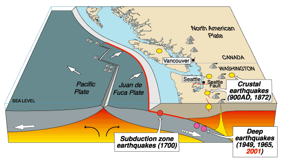
Vancouver Island is located on the western margin of the North American Plate, close to the Challenger Trench, along which the Explorer and Juan de Fuca Plate are being subducted. These are two remnant parts of the ancient Farallon Plate, which formerly underlay part of the eastern Pacific, and which has now been largely subducted beneath North America. The Explorer an Juan de Fuca Plates pass under the North American Plate as they sink into the Earth, but this is not a smooth process, with the plates constantly sticking together then breaking apart as the tectonic stresses build up.

The subduction of the Juan de Fuca Plate beneath North America. United States Geological Survey.

Witness accounts of Earthquakes can help geologists to understand these events, and the structures that cause them. The international non-profit organization Earthquake Report is interested in hearing from people who may have felt this event; if you felt this quake then you can report it to Earthquake Report here.

See also...

A mine tailings pond at the Imperial Metals operated Mount Polley Mine, an open-pit copper mine in the Cariboo Region of British Columbia was breached on Monday 4 August 2014 after...


Two people were injured when part of a cliff collapsed onto Highway 97 in British Columbia, about 6 km north of Summerland, at about 11.30 am local time on Sunday 6 July 2014. The pair, thought to be a couple in their 60s from Alberta, were taken to a local hospital for...


The Natural Resources Canada reported a Magnitude 6.6 Earthquake roughly 20 km off the southwest coast of Vancouver Island, British Columbia, at about...


Follow Sciency Thoughts on Facebook.

Thursday, 24 April 2014

Magnitude 6.6 Earthquake off the southwest coast of Vancouver Island.

The Natural Resources Canada reported a Magnitude 6.6 Earthquake roughly 20 km off the southwest coast of Vancouver Island, British Columbia, at about 8.10 pm local time on Wednesday 23 April 2014 (about 3.10 am on Thursday 24 April, GMT). This is a large quake, and was felt across much of southern British Columbia and northwest Washington State, although there are no reports of any damage or casualties, and no tsunami warning was issued.

The approximate location of the 23 April 2014 Vancouver Island Earthquake. Google Maps.

Vancouver Island is located on the western margin of the North American Plate, close to the Challenger Trench, along which the Explorer and Juan de Fuca Plate are being subducted. These are two remnant parts of the ancient Farallon Plate, which formerly underlay part of the eastern Pacific, and which has now been largely subducted beneath North America. The Explorer an Juan de Fuca Plates pass under the North American Plate as they sink into the Earth, but this is not a smooth process, with the plates constantly sticking together then breaking apart as the tectonic stresses build up.

The subduction of the Juan de Fuca Plate beneath North America. United States Geological Survey.

Witness reports can help geologists to understand the processes going on in Earthquakes and the structures in the rocks that cause them. If you felt this quake you can report it to Natural Resources Canada here.

See also...


Follow Sciency Thoughts on Facebook.

Tuesday, 24 September 2013

Magnitude 2.6 Earthquake near the Grand Canyon in Arizona.

The United States Geological Survey recorded a Magnitude 2.6 Earthquake at a depth of 4.9 km roughly 18 km to the north of the Grand Canyon in northeast Arizona, slightly after 6.35 pm local time on Sunday 22 September 2013 (slightly after 1.35 am on Monday 23 September GMT). A quake this size is unlikely to cause any damage or injuries, but is likely to be felt, and witnesses reported feeling this event in the town of Tusayan, roughly 28 km to the south of the epicenter of the event.


The approximate location of the 22 September 2013 Grand Canyon Earthquake. Google Maps.

Northern Arizona forms part of the Colorado Plateau, a geological province uplifted during the Laramide Orogeny between 70 and 35 million years ago as part of the ancient Farallon Plate was subducted beneath North America. The Colorado Plateau is a fairly stable geological unit, despite having been uplifted and in places having had igneous material emplaced within it, however it is bisected by a number of north-south running thrust faults associated with the uplift and continued inter-plate movement and subduction along the American west coast. Movement on these faults seldom leads to major Earthquake events, but smaller tremors are not uncommon.

Witness accounts of quakes can help geologists to understand these events and the rock structures that cause them. If you felt this quake (or if you were in the area but did not, which is also useful information) you can report it to the USGS here.

See also Two Earthquakes in Riverside County, southern California, Magnitude 2.6 Earthquake in Kern County, California, Magnitude 5.3 Earthquake in Chihuahua State, Mexico, Magnitude 2.5 Earthquake in San Bernardino County, California and Magnitude 4.1 Earthquake in northeast Baja California.

Follow Sciency Thoughts on Facebook.

Monday, 5 August 2013

Magnitude 5.3 Earthquake shakes Vancouver Island.

A Magnitude 5.5 Earthquake occurred off the southeast coast of Vancouver Island in British Columbia, slightly after 6.20 am local time (slightly after 1.20 pm GMT) on Sunday 4 August 2013, according to Natural Resources Canada. The quake was felt across much of the island, but there are no reports of any damage or casualties, and no tsunami warning has been issued.

The approximate location of the 4 August 2012 Vancouver Island Earthquake. Google Maps.

Vancouver Island is located on the western margin of the North American Plate, close to the Challenger Trench, along which the Explorer and Juan de Fuca Plate are being subducted. These are two remnant parts of the ancient Farallon Plate, which formerly underlay part of the eastern Pacific, and which has now been largely subducted beneath North America. The Explorer an Juan de Fuca Plates pass under the North American Plate as they sink into the Earth, but this is not a smooth process, with the plates constantly sticking together then breaking apart as the tectonic stresses build up.

Witness reports can help geologists to understand the processes going on in Earthquakes and the structures in the rocks that cause them. If you felt this quake you can report it to Natural Resources Canada here.


Follow Sciency Thoughts on Facebook.

Sunday, 11 November 2012

Earthquake in eastern Kentucky.

On Saturday 10 November 2012, slightly before 12.10 pm local time (slightly before 5.10 pm, GMT), the United States Geological Survey recorded a Magnitude 4.3 Earthquake 19.9 km beneath eastern Kentucky. This is not a particularly large quake, and is in a fairly sparsely populated area, but the United States Geological Survey estimate there is a 24% chance of a quake of this size in this area causing at least one fatality. This quake does not appear to have caused any damage or casualties, but it was felt up to 240 km away by residents of seven states. 

Location of the 10 November 2012 quake. Google Maps.

The American Midwest is not an area generally associated with Earthquakes, but has in fact suffered some of North Americas largest and most destructive events. This is due to the New Madrid Fault Zone, and ancient area of tectonic activity dating back to the breakup of the Rodinian Supercontinent in the Neoproterozoic, about 750 million years ago. The area is underlain by the Reelfoot Rift, a potential ocean that started to open during the Rodinian breakup but never developed. The rocks of the fault zone were drawn apart over an area that runs from Illinois to Mississippi, and suffered a number of volcanic intrusions. 750 million years later these structures are deeply buried by more modern sediments, but are also prone to movement again. North America is being squeezed by the expansion of the Atlantic Ocean to the east and the subduction of parts of the ancient Farallon Plate to the west. This necessitates some movement within the continent to relieve the stress, and the New Madrid Fault Zone provides an area of pre-existing weakness where this can happen.

The ancient rift structure beneath the New Madrid Fault Zone. Geological Survey of Alabama.


Follow Sciency Thoughts on Facebook.

Saturday, 10 November 2012

Earthquake off Vancouver Island.

On Wednesday 8 November 2012, slightly after 2.00 am local time (slightly after 6.00 pm on Thursday 7 November, GMT) the United States Geological Survey recorded a magnitude 6.3 Earthquake at a depth of 16.6 km, roughly 120 km off the southwest coast of Vancouver Island, British Columbia. This is a large quake and would potentially be very dangerous in an inhabited area, but it happened a long way off shore, and at an hour when most human beings were asleep, so there was no damage or casualties and only a few people on Vancouver Island felt the quake.

Map showing the location of the 8 November quake. Google Maps.

Vancouver Island is located on the western margin of the North American Plate, close to the Challenger Trench, along which the Explorer and Juan de Fuca Plate are being subducted. These are two remnant parts of the ancient Farallon Plate, which formerly underlay part of the eastern Pacific, and which has now been largely subducted beneath North America. The Explorer an Juan de Fuca Plates pass under the North American Plate as they sink into the Earth, but this is not a smooth process, with the plates constantly sticking together then breaking apart as the tectonic stresses build up.

Diagrammatic representation of the subduction of the Explorer and Juan de Fuca Plates beneath the North American Plate, close to Vancouver Island. Black Stars show major historic Earthquakes. Government of British Columbia.

Witness reports can help geologists to understand the processes going on in Earthquakes and the structures in the rocks that cause them. If you felt this quake you can report it to Natural Resources Canada here.


Follow Sciency Thoughts on Facebook.

Saturday, 10 September 2011

Earthquake off the coast of Vancouver Island. 9 September 2011.

On Friday 9 September 2011, just after 12.40 pm local time, an earthquake occurred roughly 20 km off the Pacific Coast of Vancouver Island, roughly 250 km east of Vancouver City. The quake was measured as having a depth of 23 km and a magnitude of 6.4 on the Richter Scale by the United States Geological Survey. This caused shaking that was felt across much of coastal British Columbia and Oregon. There are no reports of any damage or casualties, probably due in part to the remote location of the quake, and no tsunami warning has been issued.
Vancouver Island is located to the northeast of a subductive plate boundary, where the Juan de Fuca and Explorer Plates are being subducted beneath the North American Plate. The Explorer and Juan de Fuca Plates are remnants of an ancient oceanic plate, the Fallaron Plate which has almost completely disappeared beneath North America. The Fallaron Plate formerly diverged from the Pacific Plate along the Fallaron Ridge, but as the plate has been subducted both it and the ridge have broken up. The remnants of the plate are now the Explorer Plate in the north, then the Juan de Fuca Plate, then the Gorda Plate in the south. This borders onto the Pacific Plate along the Mendocino Fracture Zone, which extends on land as the San Andreas Fault.

The tectonic margins along the eastern coast of North America.

The Juan de Fuca Plate does not flow smoothly beneath Vancouver Island, but moves in a series of stops and starts as the rocks stick to one another then move suddenly once the pressure builds up sufficiently. This has lead to some spectacular quakes, most notably the 1949 Queen Charlotte Islands Earthquake, which measured 8.1 on the Richter Scale and caused several landslides and widespread damage to property, the 1946 Vancouver Earthquake, which measured 7.3 on the Richter Scale, killed two people and damaged a number of buildings and the 1700 Cascadia Earthquake which had an estimated magnitude of between 8.7 and 9.1 on the Richter Scale, and triggered a tsunami which reached Japan and caused widespread devastation.
The epicentre of the 1946 Vancouver Earthquake, in relation to the Juan de Fuca subduction Zone.

If you felt this quake you can report it to the United States Geological Survey here.

Wednesday, 10 August 2011

Scientists predict eruption of Axial Seamount. August 2011.

Axial Seamount is a submarine volcano located on the Juan de Fuca Ridge, 480 km west of the Oregon Coast. It has been the subject of extensive study as it is extremely active and is of complex origins: it is on the intersection of the Cobb Hotspot Seamount Chain, and the Juan de Fuca extensional ridge; it is also close to the Blanco Fracture Zone. The seamount rises 700 m above the rest of the Juan de Fuca Ridge and about 1100 m above the surrounding sea floor; it is 1400 m bellow the sea surface. It is a biodiversity hotspot, hosting several 'black-smokers' - underwater hot springs producing super-heated mineral rich water, which support unique ecosystems.

The location of the Axial Seamount.


The Juan de Fuca Ridge, including Axial Seamount, was discovered by the SEASAT satellite using satellite alimentary, a technique which bounces radio-waves of the sea-floor to build up a three dimensional picture. SEASAT was a satellite launched by NASA's Jet Propulsion Laboratory in 1978. It carried a range of instruments intended to study and monitor the world's oceans. Its mission was short-lived, being cut off by a massive short-circuit 105 days after its launch.

In 1981 the National Oceanic and Atmospheric Administration (NOAA) Survey Ship Surveyor carried out a bathymetric study of the area using ship mounted sonar and thermal mapping equipment. This identified a number of thermal hotspots.

In 1983 the ridge was explored by the NOAAs submersible Pisces IV and 1984 by the Woods Hole Oceanographic Institution's DSV Alvin, between them discovering a number of black smokers. The Axial Seamount was named for its position on the intersection (Axis) between the Juan de Fuca Ridge and the Cobb Seamount Chain.

The DSV Alvin.

The seamount was further investigated by the NOASS Discoverer in 1991 and the German research ship RV Sonne in 1996. Later in 1996 the NOAA founded the New Millennium Observatory at Mount Axial, the first ever permanent monitoring station at a submarine volcano.

In January 1998 this reported a marine eruption on the site; when the site was visited in February it was found that there had indeed been an eruption, burying some of the station's equipment but confirming that the station was indeed able to detect eruptions.

In 2006 Bill Chadwick of the Hatfield Marine Science Center at Oregon State University and Scott Nooner of the Lamont-Doherty Earth Observatory at Columbia University published a paper in the Journal of Volcanology and Geothermal Research in which they analyzed movements on the sea-floor before and after the 1998 eruption, and found that there had been a long period of inflation prior to the eruption, followed by an abrupt deflation of the sea-floor during the eruption, with 3.2 m of subsidence. They then analyzed more recent data from the seamount and found that the sea-floor was once again swelling. From this they concluded that Axial Seamount was likely to erupt again within 8 years.

In April this year (2011) monitors on the seamount once again detected signs of an eruption, and in late July a visit by the Woods Hole Oceanographic Institutions ship RV Atlantis revealed that there had indeed been an eruption, with extensive lava flows, already showing signs of new colonization by benthic animals.

The Juan de Fuca ridge marks the extensional margin between the Juan de Fuca Plate and the Pacific Plate. The Juan de Fuca Plate is thought to be a remnant of an ancient plate known as the Farallon Plate, a once vast plate now largely subducted beneath the North American Plate. There are three remnants of this plate remaining off the west coast of the US; the Juan de Fuca Plate, the Gorda Plate to the south and the Explorer Plate to the north. The Juan de Fuca Ridge was once part of the longer Farallon Ridge, which ran along the eastern margin of the Farallon Ridge before it was fractured into three parts.

The former parts of the Farallon Plate.

The Cobb Seamount Chain runs from the Aleutian Trench off the south coast of Alaska south to Axial Seamount. It is gets its name from the Cobb Seamount, which is 500 km west of the Washington coast, and was named after the research vessel MV John M Cobb; this can cause some confusion as other objects on the seafloor of the NE Pacific are also named after this vessel (Cobb) and are not necessarily related to the seamount chain.

The Cobb Seamount Chain, top right.