Showing posts with label Juan de Fuca Ridge. Show all posts

Wednesday, 25 December 2019

Magnitude 6.2 Earthquake off the west coast of Vancouver Island.

Natural Resources Canada reported a Magnitude 6.2 Earthquake at a depth of 5 km roughly 182 km off the west coast of Vancouver Island, British Columbia, slightly after 7.35 pm local time on Tuesday 24 December 2019 (slightly after 3.35 am on Wednesday 25 December, GMT). This is a large quake, and was felt across much of southern British Columbia and northwest Washington State, although there are no reports of any damage or casualties, and no tsunami warning was issued.

The approximate location of the 24 December 2019 Vancouver Island Earthquake. USGS.

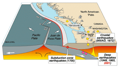
Vancouver Island is located on the western margin of the North American Plate, close to the Challenger Trench, along which the Explorer and Juan de Fuca Plate are being subducted. These are two remnant parts of the ancient Farallon Plate, which formerly underlay part of the eastern Pacific, and which has now been largely subducted beneath North America. The Explorer an Juan de Fuca Plates pass under the North American Plate as they sink into the Earth, but this is not a smooth process, with the plates constantly sticking together then breaking apart as the tectonic stresses build up.

 The subduction of the Juan de Fuca Plate beneath North America. United States Geological Survey.

On this occasion the Earthquake occurred on the northern part of the Juan de Fuca Plate, close to the Juan de Fuca Ridge. The Juan de Fuca ridge marks the extensional margin between the Juan de Fuca Plate and the Pacific Plate. The Juan de Fuca Plate is thought to be a remnant of an ancient plate known as the Farallon Plate, a once vast plate now largely subducted beneath the North American Plate. There are three remnants of this plate remaining off the west coast of the US; the Juan de Fuca Plate, the Gorda Plate to the south and the Explorer Plate to the north. The Juan de Fuca Ridge was once part of the longer Farallon Ridge, which ran along the eastern margin of the Farallon Ridge before it was fractured into three parts.

Spreading on the Juan de Fuca Ridge, and its relationship to the volcanoes of the North American west coast. Wikimedia Commons.

Witness reports can help geologists to understand the processes going on in Earthquakes and the structures in the rocks that cause them. If you felt this quake you can report it to Natural Resources Canada here.
 
See also...
 
https://sciencythoughts.blogspot.com/2019/04/avalanche-on-des-poilus-glacier-kills.htmlhttps://sciencythoughts.blogspot.com/2019/01/avalanche-kills-skier-in-british.html
 
https://sciencythoughts.blogspot.com/2018/10/three-major-earthquakes-off-west-coast.htmlhttps://sciencythoughts.blogspot.com/2018/05/homes-evacuated-due-to-wildfires-in.html
https://sciencythoughts.blogspot.com/2018/05/canadian-couple-survive-being-swept-of.htmlhttps://sciencythoughts.blogspot.com/2018/03/avalanche-kills-skier-in-british.html
Follow Sciency Thoughts on Facebook.

Tuesday, 23 October 2018

Three major Earthquakes off the west coast of British Columbia.

Natural Resources Canada recorded a series of three Earthquakes at a depth of 10 km about 200 km off the west coast of British Columbia on 21/22 October 2018, with the first occurring slightly before 10.40 pm local time on Sunday 21 October (slightly before 5.40 am on Monday 22 October GMT), and having a Magnitude of 6.5 , the second occurring slightly after 11.15 pm local time (slightly after 6.15 am GMT), and having a Magnitude of 6.8, and the third occurring slightly after 11.20 pm local time (slightly after 6.20 am GMT) and having a Magnitude of 6.5. These events were felt along much of the coast of British Columbia and Washington State, but there are no reports of any damage or casualties.

The approximate location of the 21/22 October 2018 British Columbia Earthquakes. USGS.

Vancouver Island is located on the western margin of the North American Plate, close to the Challenger Trench, along which the Explorer and Juan de Fuca Plate are being subducted. These are two remnant parts of the ancient Farallon Plate, which formerly underlay part of the eastern Pacific, and which has now been largely subducted beneath North America. The Explorer an Juan de Fuca Plates pass under the North American Plate as they sink into the Earth, but this is not a smooth process, with the plates constantly sticking together then breaking apart as the tectonic stresses build up.

 The subduction of the Juan de Fuca Plate beneath North America. United States Geological Survey.

On this occasion the Earthquake occurred on the northern part of the Juan de Fuca Plate, close to the Juan de Fuca Ridge. The Juan de Fuca ridge marks the extensional margin between the Juan de Fuca Plate and the Pacific Plate. The Juan de Fuca Plate is thought to be a remnant of an ancient plate known as the Farallon Plate, a once vast plate now largely subducted beneath the North American Plate. There are three remnants of this plate remaining off the west coast of the US; the Juan de Fuca Plate, the Gorda Plate to the south and the Explorer Plate to the north. The Juan de Fuca Ridge was once part of the longer Farallon Ridge, which ran along the eastern margin of the Farallon Ridge before it was fractured into three parts.

 Spreading on the Juan de Fuca Ridge, and its relationship to the volcanoes of the North American west coast. Wikimedia Commons.

Witness reports can help geologists to understand the processes going on in Earthquakes and the structures in the rocks that cause them. If you felt any of these quakes you can report it to Natural Resources Canada here.

See also...

https://sciencythoughts.blogspot.com/2018/05/homes-evacuated-due-to-wildfires-in.htmlhttps://sciencythoughts.blogspot.com/2018/05/canadian-couple-survive-being-swept-of.html
https://sciencythoughts.blogspot.com/2018/03/avalanche-kills-skier-in-british.htmlhttps://sciencythoughts.blogspot.com/2018/02/british-colombia-avalache-victim-dies.html
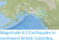
https://sciencythoughts.blogspot.com/2018/01/homes-evacuated-after-landslide-in.htmlhttps://sciencythoughts.blogspot.com/2017/05/magnitude-62-earthquake-in-northwest.html
Follow Sciency Thoughts on Facebook.

Sunday, 28 June 2015

Understanding current flows in hydrothermal vents.


Hydrothermal vents are areas on the sea floor where water warmed by the heat of the Earth’s interior escapes into the wider ocean. These waters contain high levels of dissolved minerals and nutrients rare in the wider oceans, and therefore support unique ecosystems able to survive without any input of solar energy. The most extreme examples of hydrothermal vents are the black smokers found around volcanically active ocean ridges. These vents produce water with temperatures reaching hundreds of degrees centigrade, kept liquid only by the high pressures present on the ocean floor, and opaque due to the high levels of minerals present. However hydrothermal vents are also present on areas of the ocean floor far from the active ridges, or any other form of volcanic influence, apparently emitting water that has been transported hundreds of kilometres beneath the ocean floor, which is far harder to explain.

In a paper published in the journal Nature Communications on 26 June 2015, Dustin Winslow of the Earth and Planetary Sciences Department at the University of California Santa Cruz and Andrew Fisher of the Earth and Planetary Sciences Department and Institute for Geophysics and Planetary Physics at the University of California Santa Cruz describe the results of a computer model of water flows supplying water to hydrothermal vents on the ocean floor, based upon observations of vents around the Juan de Fuca Ridge off the northwest coast of North America, which appears to solve the mystery of water supply to distant hydrothermal vents.

Marine sediments tend to be very rich in clay minerals, and are thus effectively impermeable to the flow of water. However the volcanic rocks that lay beneath these sediments tend to be highly porous, allowing the free transport of water. Therefore areas of exposed rock can act as either entrances or exits for water moving through subsurface aquifers, which are isolated from the general ocean in areas where the volcanic bedrock is covered by sediments. Observational evidence from around the Juan de Fuca Ridge suggest that whether an area of exposed volcanic rock serves as an entrance or exit to the aquifer is driven by the size of the exposure rather than other factors, such as proximity to volcanic heating, or the temperature or current speeds of the water passing over the entrances, with hydrothermal vents (i.e. areas where water exits from the aquifers) always occurring from exposed rocks with limited areas.

Geometry and configuration of 3D domains. Domains represent a section of upper ocean crust, oriented with the long-axis parallel to the spreading ridge, consistent with conditions at a field site on the eastern flank of the Juan de Fuca Ridge. A conductive volcanic rock section (red, lower permeability) is overlain by a crustal aquifer (orange, higher permeability) and marine sediments (blue, lower permeability) and two volcanic rock outcrops penetrate through the sediment (light blue). Heat is applied to the base, following a lithospheric cooling trend. The sides and base are no-fluid flow boundaries, and the top is free flow (fluid and heat) with pressure varying as a function of seafloor depth. Winslow & Fisher (2015).

Winslow and Fisher simulated flows between outcrops of different sizes, through subsurface aquifers being heated gently but evenly and constantly from below. They initially tried modelling systems where the current was present at the start of the experiment, on the basis that establishing a system and maintaining it are not the same, but found that even where no current was present at the outset of the experiment, a current flow from the larger opening to the smaller was quickly established.

Larger areas of permeable rock exposure allow both the entrance and exit of water across their surface, whereas smaller openings allow movement in only one direction. As warmer water rises from the vent into the water column warm water exiting from the vent quickly comes to dominate the flow of water at smaller vents, particularly if these are raised above the surrounding area (i.e. sticking up through the mud). This in turn leads to a draw on the waters of the aquifer, effectively pulling water through from the larger areas of exposure.

Simulation results at dynamic steady state. This simulation, showing one quarter of the domain illustrated in the top figure, has one large outcrop and one small outcrop. Domain colours show domain temperatures, including influence of rolling/mixed convection in basement aquifer and thermal influence of recharging/discharging outcrops. Inset diagrams show fluid flow vectors within and around outcrops (length indicates flow rate), with vectors plotted on a natural-log scale, the longest vector (exiting the top of the discharging outcrop) corresponding to a flow rate of 14m per year. Fluid flow through the sediment is so slow that it would generate no detectable thermal or geochemical anomalies. Vertical exaggeration (VE) of main image is times three; VE of inset images is times two. Winslow & Fisher (2015).

Hydrothermal vents are thought to account for about 25% of heat loss from the Earth’s interior, which if correct suggests that a very large amount of water is exiting from such vents every day. Despite this such vents are notoriously hard to find, with efforts to locate them with satellites having been largely inconclusive, and most known vents having been discovered by exploratory missions involving deep-sea submersibles. Winslow and Fisher’s findings suggest that a preference for such vents occurring on smaller outcrops is a genuine natural phenomenon, rather than a product of the observation methods being used. This would explain the difficulty in finding such vents using satellites, as very small discrete vents, no matter how numerous, would fall below the area/size at which it was possible to detect them using remote sensing technology.

See also…

A seismic monitoring system beneath the northeast Pacific operated by the Ocean Observatories Initiative has detected a probable eruption on Axial Seamount, a submarine volcano roughly 480 km off the coast of Oregon. The network has detected...


Hydrothermal vents in the deep oceans are colonized by a broad array of invertebrates that have symbiotic relationships with chemotropic Bacteria. These Bacteria are able to derive energy from chemicals discharged by the vents, providing a base for ecosystems entirely separated from the light of the Sun. Not all...


Deep sea hydrothermal vents are unique ecosystems where the food chain is based not upon the photosynthetic activity of plants or algae, but rather of chemotrophic bacteria that gain their energy from...


Follow Sciency Thoughts on Facebook.

Tuesday, 5 May 2015

Eruptive activity on Axial Seamount.

A seismic monitoring system beneath the northeast Pacific operated by the Ocean Observatories Initiative has detected a probable eruption on Axial Seamount, a submarine volcano roughly 480 km off the coast of Oregon. The network has detected around 8000 minor Earthquakes since Friday 1 May, accompanied by a drop in the sea-floor level of about 2.4 meters. Minor tremors around volcanoes are most commonly caused by magma moving through subterranean chambers beneath the vent of the volcano, and are therefore used as advances warning of eruptions. In this instance any eruption would be hard to directly observe due to its remote location, but presents little danger to any human settlement for the same reason.

A vent on Axial Seamount. Schmidt Ocean Institute.

Axial Seamount is a submarine volcano located on the Juan de Fuca Ridge, 480 km west of the Oregon Coast. It has been the subject of extensive study as it is extremely active and is of complex origins: it is on the intersection of the Cobb Hotspot Seamount Chain, and the Juan de Fuca extensional ridge; it is also close to the Blanco Fracture Zone. The seamount rises 700 m above the rest of the Juan de Fuca Ridge and about 1100 m above the surrounding sea floor; it is 1400 m bellow the sea surface. It is a biodiversity hotspot, hosting several 'black-smokers' - underwater hot springs producing super-heated mineral rich water, which support unique ecosystems.

The volcano appears to have a very regular eruptive cycle, enabling scientists to predict eruptions by the rate at which it inflates due to magma movements. It currently appears to be erupting roughly once every four years, having last erupted in 2011, and a 2015 eruption was predicted by Bill Chadwick of Oregon State University and Scott Nooner of the University of North Carolina Wilmington in September 2014.

The approximate location of Axial Seamount. Google Maps.

The Juan de Fuca ridge marks the extensional margin between the Juan de Fuca Plate and the Pacific Plate. The Juan de Fuca Plate is thought to be a remnant of an ancient plate known as the Farallon Plate, a once vast plate now largely subducted beneath the North American Plate. There are three remnants of this plate remaining off the west coast of the US; the Juan de Fuca Plate, the Gorda Plate to the south and the Explorer Plate to the north. The Juan de Fuca Ridge was once part of the longer Farallon Ridge, which ran along the eastern margin of the Farallon Ridge before it was fractured into three parts.

Spreading on the Juan de Fuca Ridge, and its relationship to the volcanoes of the North American west coast. Wikimedia Commons.

The Cobb Seamount Chain runs from the Aleutian Trench off the south coast of Alaska south to Axial Seamount. It is gets its name from the Cobb Seamount, which is 500 km west of the Washington coast, and was named after the research vessel MV John N Cobb; this can cause some confusion as other objects on the seafloor of the NE Pacific are also named after this vessel (Cobb) and are not necessarily related to the seamount chain.

See also...

Axial Seamount is a submarine volcano located on the Juan de Fuca Ridge, 480 km west of the Oregon Coast. It has been the subject of extensive study as it is extremely active and is of complex origins: it is on...


Follow Sciency Thoughts on Facebook.

Saturday, 10 September 2011

Earthquake off the coast of Vancouver Island. 9 September 2011.

On Friday 9 September 2011, just after 12.40 pm local time, an earthquake occurred roughly 20 km off the Pacific Coast of Vancouver Island, roughly 250 km east of Vancouver City. The quake was measured as having a depth of 23 km and a magnitude of 6.4 on the Richter Scale by the United States Geological Survey. This caused shaking that was felt across much of coastal British Columbia and Oregon. There are no reports of any damage or casualties, probably due in part to the remote location of the quake, and no tsunami warning has been issued.
Vancouver Island is located to the northeast of a subductive plate boundary, where the Juan de Fuca and Explorer Plates are being subducted beneath the North American Plate. The Explorer and Juan de Fuca Plates are remnants of an ancient oceanic plate, the Fallaron Plate which has almost completely disappeared beneath North America. The Fallaron Plate formerly diverged from the Pacific Plate along the Fallaron Ridge, but as the plate has been subducted both it and the ridge have broken up. The remnants of the plate are now the Explorer Plate in the north, then the Juan de Fuca Plate, then the Gorda Plate in the south. This borders onto the Pacific Plate along the Mendocino Fracture Zone, which extends on land as the San Andreas Fault.

The tectonic margins along the eastern coast of North America.

The Juan de Fuca Plate does not flow smoothly beneath Vancouver Island, but moves in a series of stops and starts as the rocks stick to one another then move suddenly once the pressure builds up sufficiently. This has lead to some spectacular quakes, most notably the 1949 Queen Charlotte Islands Earthquake, which measured 8.1 on the Richter Scale and caused several landslides and widespread damage to property, the 1946 Vancouver Earthquake, which measured 7.3 on the Richter Scale, killed two people and damaged a number of buildings and the 1700 Cascadia Earthquake which had an estimated magnitude of between 8.7 and 9.1 on the Richter Scale, and triggered a tsunami which reached Japan and caused widespread devastation.
The epicentre of the 1946 Vancouver Earthquake, in relation to the Juan de Fuca subduction Zone.

If you felt this quake you can report it to the United States Geological Survey here.

Wednesday, 10 August 2011

Scientists predict eruption of Axial Seamount. August 2011.

Axial Seamount is a submarine volcano located on the Juan de Fuca Ridge, 480 km west of the Oregon Coast. It has been the subject of extensive study as it is extremely active and is of complex origins: it is on the intersection of the Cobb Hotspot Seamount Chain, and the Juan de Fuca extensional ridge; it is also close to the Blanco Fracture Zone. The seamount rises 700 m above the rest of the Juan de Fuca Ridge and about 1100 m above the surrounding sea floor; it is 1400 m bellow the sea surface. It is a biodiversity hotspot, hosting several 'black-smokers' - underwater hot springs producing super-heated mineral rich water, which support unique ecosystems.

The location of the Axial Seamount.


The Juan de Fuca Ridge, including Axial Seamount, was discovered by the SEASAT satellite using satellite alimentary, a technique which bounces radio-waves of the sea-floor to build up a three dimensional picture. SEASAT was a satellite launched by NASA's Jet Propulsion Laboratory in 1978. It carried a range of instruments intended to study and monitor the world's oceans. Its mission was short-lived, being cut off by a massive short-circuit 105 days after its launch.

In 1981 the National Oceanic and Atmospheric Administration (NOAA) Survey Ship Surveyor carried out a bathymetric study of the area using ship mounted sonar and thermal mapping equipment. This identified a number of thermal hotspots.

In 1983 the ridge was explored by the NOAAs submersible Pisces IV and 1984 by the Woods Hole Oceanographic Institution's DSV Alvin, between them discovering a number of black smokers. The Axial Seamount was named for its position on the intersection (Axis) between the Juan de Fuca Ridge and the Cobb Seamount Chain.

The DSV Alvin.

The seamount was further investigated by the NOASS Discoverer in 1991 and the German research ship RV Sonne in 1996. Later in 1996 the NOAA founded the New Millennium Observatory at Mount Axial, the first ever permanent monitoring station at a submarine volcano.

In January 1998 this reported a marine eruption on the site; when the site was visited in February it was found that there had indeed been an eruption, burying some of the station's equipment but confirming that the station was indeed able to detect eruptions.

In 2006 Bill Chadwick of the Hatfield Marine Science Center at Oregon State University and Scott Nooner of the Lamont-Doherty Earth Observatory at Columbia University published a paper in the Journal of Volcanology and Geothermal Research in which they analyzed movements on the sea-floor before and after the 1998 eruption, and found that there had been a long period of inflation prior to the eruption, followed by an abrupt deflation of the sea-floor during the eruption, with 3.2 m of subsidence. They then analyzed more recent data from the seamount and found that the sea-floor was once again swelling. From this they concluded that Axial Seamount was likely to erupt again within 8 years.

In April this year (2011) monitors on the seamount once again detected signs of an eruption, and in late July a visit by the Woods Hole Oceanographic Institutions ship RV Atlantis revealed that there had indeed been an eruption, with extensive lava flows, already showing signs of new colonization by benthic animals.

The Juan de Fuca ridge marks the extensional margin between the Juan de Fuca Plate and the Pacific Plate. The Juan de Fuca Plate is thought to be a remnant of an ancient plate known as the Farallon Plate, a once vast plate now largely subducted beneath the North American Plate. There are three remnants of this plate remaining off the west coast of the US; the Juan de Fuca Plate, the Gorda Plate to the south and the Explorer Plate to the north. The Juan de Fuca Ridge was once part of the longer Farallon Ridge, which ran along the eastern margin of the Farallon Ridge before it was fractured into three parts.

The former parts of the Farallon Plate.

The Cobb Seamount Chain runs from the Aleutian Trench off the south coast of Alaska south to Axial Seamount. It is gets its name from the Cobb Seamount, which is 500 km west of the Washington coast, and was named after the research vessel MV John M Cobb; this can cause some confusion as other objects on the seafloor of the NE Pacific are also named after this vessel (Cobb) and are not necessarily related to the seamount chain.

The Cobb Seamount Chain, top right.