Showing posts with label Atlantic Ocean. Show all posts

Saturday, 18 October 2025

Chelonia mydas: The Green Sea Turtle no longer considered to be Endangered as population recovers.

Green Sea Turtles, Chelonia mydas, is a widespread marine Turtle, found across tropical and sub-tropical regions of the Pacific, Indian, and Atlantic Oceans, as well associated seas. Due to this widespread distribution, it is probably also the most numerous Turtle species. However, it has historically been hunted by Humans across its range, with both adults and eggs being considered desirable foods and the skin used to make leather for luxury goods. High levels of hunting, combined with a slow reproductive cycle (the average generation time for Green Sea Turtles is 45 years) led to the species being listed as Endangered under the terms of the International Union for the Conservation of Nature's Red List of Threatened Species in 1982, and subsequently all trade in Green Turtles or Green Turtle-derived products been banned under the Convention on International Trade in Endangered Species.

A Green Sea Turtle, Chelonia mydas. Xanthe Rivett/International Union for the Conservation of Nature.

The conservation status of Green Sea Turtles has subsequently been reviewed in 1986, 1988, 1990, 1994, 1996, 2004, and 2023. During this time many countries across its range have enacted laws to protect both the species and its breeding grounds, and raised public awareness across the globe of the threat to a fairly charismatic species has made the consumption of Turtles and their eggs much less acceptable in many places (although the practice has never completely ceased). 

On 10 October 2025 the conservation status of the Green Sea Turtle was updated from Endangered to Least Concern. This is based upon the observation of 526 000 clutches of eggs hatching successfully in 2024, a 28% increase on the estimated breeding success rate for the mid twentieth century; because adult Green Sea Turtles are solitary animals widely distributed across the worlds oceans, it has never been possible to assess their adult population directly.

This does not mean that all threats to Green Sea Turtles have been eliminated. The species is still consumed in places, it is widely caught as a by-catch of fishing fleets, and it breeds on sandy tropical beaches highly desirable to developers. It is also considered to be vulnerable to the effects of global warming, as well as plastic waste in the oceans. Several populations of Green Sea Turtles are still considered to be locally threatened. Nevertheless, there is not now thought to be any immediate danger of the species becoming extinct.

See also...


Thursday, 24 July 2025

Rypticus africanus: A new species of Soapfish from the eastern Atlantic.

Soapfish, Grammistes and Rypticus spp., are bottom-dwelling Perciform Fish related to Groupers, generally found on reefs and other rocky marine environments. They get their common name from their ability to secrete a toxic, soapy, mucus as a defence mechanism. The genus Grammistes is restricted to the Indo-Pacific region, while members of the genus Rypticus are found in the Western Pacific, Atlantic and Caribbean. Only two species of Rypticus have been found on the African coast, the Greater Soapfish, Rypticus saponaceus, and the Spotted Soapfish, Rypticus subbifrenatus. The Greater Soapfish is known from both sides of the Atlantic being found from the coast of Florida, throughout the Caribbean, and as far south as Brazil in the western Atlantic, and from Mauritania south as far as Angola in the eastern Atlantic. However, a genetic study of museum specimens published in 2003 suggested that the eastern and western populations of the Greater Soapfish might in fact be separate species.

In a paper published in the Journal of Fish Biology on 21 July 2025, Gabriel Soares Araujo of the Center for Marine Biology at the University of São Paulo, Cláudio Sampaio of the Laboratório de Ictiologia e Conservação at the Universidade Federal de Alagoas, Luiz Rocha of the  Department of Ichthyology at the California Academy of Sciences, and Carlos Eduardo Ferreira Leite of the Departamento de Biologia Marinha at the Universidade Federal Fluminense, re-examine the genetics of the Greater Soapfish, and formally describe the populations from the African coast as a separate species.

Araujo et al. examined specimens from Cape Verde, Ghana, São Tomé and Príncipe, and Togo. All were found to be genetically distinct from western Atlantic specimens of Rypticus saponaceus, forming a distinct population which is estimated to have split from the west Atlantic population in the Early Pleistocene, about 2.5 million years ago, at the onset of the Pleistocene, and surprisingly being more closely related to the Pacific Rypticus bicolor. Since Rypticus saponaceus was originally described from specimens from Florida, the east Atlantic population is described as a new species, which Araujo et al. name Rypticus africanus.

Time-calibrated phylogeny of the genus Rypticus based on mitochondrial COI gene sequences. Values near the nodes represent estimated divergence times (Mya). The 95% highest posterior density intervals are shown in parentheses. Coloured circles represent the biogeographic regions where species of Rypticus are distributed. Vertical bars depict the results of lineage delimitation tests. Araujo et al. (2025).

Specimens of Rypticus africanus examined range from 112 to 215 mm in length, and have three dorsal fin spines, 22-24 dorsal fin rays, 15-17 anal fin rays, 16-18 pectoral fin rays, and 24-25 caudal (tail) fin rays. The head is distinctly pointed, the dorsal fin originates slightly posterior to upper end the of gill opening, and the tail is rounded. They are brown or dark grey in colour, with numerous pale round spots of variable size on their flanks.

(a)–(c) Rypticus africanus from São Tomé and Príncipe, illustrating the variation in colour pattern between individuals: (a) São Tomé Island, (b), (c) Príncipe Island and (d) Rypticus saponaceus from Salvador, Bahia, Brazil, shown for comparison. Araujo et al. (2025).

Although Rypticus africanus has only been sampled from four areas (Cape Verde, Ghana, São Tomé and Príncipe, and Togo), Araujo et al. believe the name should be applied to all African populations currently described as Rypticus saponaceus, from Mauritania to Angola.

See also

Friday, 3 January 2025

Using strontium isotope ratios to try to determine the origin of victims of the transAtlantic slave trade.

Between the fifteenth to nineteenth centuries, at least 12.5 million people were abducted from sub-Saharan Africa and taken as slaves to the Americas, and to a lesser extent Europe, the largest forced migration in Human history. This has had a profound impact on the demographics, economics, and politics of both Africa and the Americas, and while is some ways the process was well-documented (we have, for example, documented records of the voyages of at least 30 079 vessels which were involved in the slave trade, including records of ports they visited and the number of captives they transported), we know very little about the identities of the individuals involved and their actual points of origin.

Recent studies have used genetic information from archaeological remains from the Caribbean, Brazil, North America, St Helena, and South Africa, have had some success in determining the populations from which individuals descended, this cannot tell us where they a person was born or brought up.

Strontium isotopes (specifically the ratio between the isotopes strontium⁸⁷ and strontium⁸⁶) in water are largely determined by bedrock, as well as rainfall and geomorphology, and is taken up and incorporated into biomineralized tissues, such as tooth and bone. Importantly, these ratios remain stable over archaeological timescales, enabling archaeologists to use them to determine the origin of Human and Animal remains, as long as a geological reference map, with the isotope ratios present in appropriate locations, is available. 

In sub-Saharan Africa, strontium isotope ratios have been used to trace the migration routes of large Mammals, and to determine the origin of ivory seized from smugglers, as well as to analyse landscape use by early Hominins, but has been under-used in other spheres, such as historical archaeology, largely because data on strontium isotope ratios are not available for large areas of the continent, and in particular much of West and West-Central Africa, the areas from which the overwhelming majority of slaves were taken to the New World. This is in part due to the high cost associated with carrying out strontium isotope testing over large areas, with the added complication that some parts of the continent are plagued by ongoing conflicts and political instability, making the necessary fieldwork difficult and dangerous.

In a paper published in the journal Nature Communications on 30 December 2024, a team of scientists led by Xueye Wang of the Center for Archaeological Science at Sichuan University and the Anthropology Department at the University of California Santa Cruz, present strontium isotope ratios from 778 new environmental studies from 24 African countries, mostly in West and West-Central Africa, which they combine with 1488 previously published strontium isotope ratios from other studies, to build a more detailed map of strontium isotope ratios across sub-Saharan Africa. These are then compared to ratios obtained from Human remains at two cemeteries in the Americas associated with African slaves, the Anson Street African Burial Ground in Charleston, South Carolina, and the Pretos Novos Cemetery in Rio de Janeiro, Brazil.

Strontium⁸⁷/strontium⁸⁶ ratios in Africa range from 0.70381 to 0.87810, a far higher range than is known from any other continent studied. Some areas have a high proportion of radiogenic strontium⁸⁷, notably those areas with an underlying Archaean bedrock, such as Angola, Zimbabwe, Zambia, western Tanzania, northern South Africa, Côte d'Ivoire, Liberia, Sierra Leone, and southwestern Mali. Other areas have a very low level of strontium⁸⁷, particularly areas of East Africa covered by Mesozoic-Cainozoic volcanic rocks, and areas of South Africa covered by flood basalts, as these tend to generate soils with a high cation exchange capacity and clay content. Strontium ratios are also affected by precipitation levels and elevation, both of which impact the weathering rate of silicate rocks.
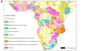
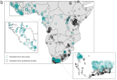
Geological map and sampling locations. (a) Simplified geological map. (b) Map showing the environmental sampling locations from this study and previously published work. The sampling locations focused on filling gaps in West Africa, West-Central Africa, and parts of South Africa, covering all major geological units across the African continent south of the Sahara. Wang et al. (2024).

Strontium isotope ratios were analysed for five individuals from the Anson Street African Burial Ground for which genetic analysis had been used to determine a population-of-origin, and five individuals from the Pretos Novos Cemetery, for which this data was not available, but oxygen isotope ratios, which can be used to determine diet, were.

Two of the Anson Street African Burial Ground individuals had previously been determined to be of West-Central African origin, both of which produced strontium isotope ratios consistent with an origin in eastern-central Angola. The remaining three individuals were all determined to be from West Africa by genetic analysis. The first of these produced a strontium isotope ratio which indicates that they could have originated from a wide area, including large regions of Liberia, Côte d’Ivoire, Guinea, Sierra Leone, and Mali. The remaining two individuals showed much higher levels of radiogenic strontium, consistent with having come from either a 100 km stretch of the coast of southern Côte d’Ivoire and Ghana, or from the eastern part of Guinea.

Four of the five individuals from the Pretos Novos Cemetery produced strontium isotope ratios consistent with having come from different regions of Angola or South-East Africa, while the fifth produced a result consistent with having come from parts of Guinea, Nigeria, Cameroon, or South Africa. 

Oxygen isotope ratios suggest that this individual grew up in a region where the main crops were C₄ Plants. This would exclude the 'Rice Coast' of West Africa, which runs from Guinea Bissau through Guinea into western Côte d’Ivoire, or the vegecultural zone of southern West Africa, where the predominant crops are Manioc, Yams, and other C₃ root vegetables, but would include parts of central Nigeria where the main crops are Sorghum and Millet, and parts of northern Cameroon where different areas would have grown Sorghum and Millet or Maize (itself introduced from the Americas by European traders). Potentially, a South African could have also had a diet dominated by C₄ Plants, which are easily grown in many places there, but Wang et al. consider this less likely, given the much larger number of slaves taken from West Africa to Brazil.

The four other individuals from Pretos Novos Cemetery are hypothesized to have come from different parts of Angola based upon strontium isotope ratios. This was supported by the oxygen isotope analysis, which suggests they did not share common dietary habits in early life. This is consistent with the known agricultural practices in Angola at the time, with different regions emphasizing the cultivation of manioc and other root crops, or maize and millet.

Wang et al. are confident that improved groundwater sampling from a wider area of Africa would have the potential to greatly improve our ability to determine the origin of African remains from the New World. With the limited sampling available, they were able to provide approximate locations of origin for ten individuals from two well-studied burial grounds, one in the United States and the other in Brazil, and while their answers cannot be taken as 100% reliable at this stage, none of them contradict data from previous studies, nor do they suggest improbable points of origin for the individuals examined.

There are still some notable gaps in the strontium ratio maps used by Wang et al. most notably Namibia and the Sahel Region. Wang et al. identify these regions as being sparsely populated, and therefore unlikely to have been heavily targeted by slavers. This is probably true for Namibia, where the most habitable areas are separated from the coat be large areas of desert, but certainly isn't true for the Sahel Region, which was home to powerful states such as the Mali Empire, and where travellers such as Mungo Park recorded extensive activity by slavers. Sampling is also limited for Mozambique, from where historical records show that at least half a million people were taken as slaves in the first half of the nineteenth century. The method is further limited in that it can only trace the origins of people born and raised in Africa, anyone raised in the Americas will have a strontium isotope signal from there, no matter where their parents came from.

Wang et al. also note that an improved isotope map for Africa, particularly if it includes other elements, such as oxygen, hydrogen, sulphur, and carbon, has the potential to improve not just our ability to identify the origins of Human remains from archaeological contexts, but also items such as smuggled wildlife and timber. It also has the ability to improve our understanding of wildlife migrations, or historic dispersals, including those of species extinct today. Moreover, it also has the ability to help identify the thousands of African migrants who perish in the Mediterranean Sea during their passage to southern Europe, something which has been described as potentially the greatest humanitarian disaster in Europe since the Second World War.

See also...

Saturday, 7 December 2024

Fissidentalium aurae: A new species of deepwater Anemone-associated Scaphopod from the Labrador Sea.

Scaphopods, or Tusk Shells, are a distinct group of Molluscs found exclusively living infaunally (i.e. beneath sediments) in marine environments, although they are found in all oceans from the shallow continental shelves to the deepest abyssal environments. Scaphopods have an elongate, tapering shell, between 0.5 and 18 cm in length, curved, but never coiled, with an opening at each end. The body of the Scaphopod is entirely contained within this shell, although it's foot can be extended from the larger opening, to drag the Animal through the sediment. Water is drawn in through the smaller opening, and passed over the mantle of the Scaphopod using cilia, with oxygen being absorbed across the mantle surface (there are no discrete gills). Food particles are extracted from the sediment by a series of tentacles surrounding the foot, and then carried to the mouth. Phylogenetic reconstructions suggest that the Scaphopods were one of the earliest-branching Mollusc groups, but their fossil record only goes back to the Early Carboniferous, making them the youngest class within the Mollusca. This could imply that earlier Scaphopod fossils simply haven't been found, or possibly that early ancestors of Scaphopods lacked shells, subsequently evolving these separately from other Molluscs.

Diagram of the scaphopod Rhabdus rectius. Wikimedia Commons.

In a paper published in the journal Marine Biology on 7 November 2024, Katrin Linse of the British Antarctic Survey and Jenny Neuhaus of the German Centre for Marine Biodiversity Research describe a  new species of deepwater Anemone-associated Scaphopod from the Labrador Sea. 

The Labrador Sea separates the northeast coast of Newfoundland from Greenland, and is an area of noted biodiversity, with an ecosystem driven by the admixture of warm waters from the Atlantic with cold waters from the Arctic. The presence of sea ice makes the Labrador Sea the least saline basin of the Atlantic Ocean, with this currently increasing due to the higher rate at which the sea ice is melting, something which impacts on both blooms of Phytoplankton and benthic organisms, and which has the potential to alter the mixing of the deep ocean currents which drive Atlantic circulation. The Labrador Sea can be divided into three bathymetric zones, a wide continental shelf on its southwestern side, the deep Labrador Basin in the centre, and a narrow, steep continental shelf on its northeastern side.

The new Scaphopod species is described on the basis of material collected by trawls of the Labrador Basin at depths of between 3380 and 3390 m, as well as observations of the seabed by remote operated vehicle. The new species is placed in the genus Fissidentalium, and given the specific name aurae, meaning 'breeze', in reference to the windy conditions in the area when the survey was being caried out, as well as to Briese Research, the company which operated the remote operated vehicle used in the research. Genetic analysis confirmed that Fissidentalium aurae is a new species.

Fissidentalium aurae; (a)–(b) Holotype SMF 366428, side and anterior view of shell and associated Anemone; (c)–(d) Paratype 2 NHMUK 20230932, side view of shell and Anemone and soft parts; (e) Paratype 3 NHMUK 20230933, side view of dead shell. Arrows indicate delineation of the Anemones. Linse & Neuhaus (2024).

Specimens of Fissidentalium aurae are between 15.52 and 63.63 mm in length, and an opaque white in colour, with longitudinal ribs on the shell. Of the 19 Scaphopod specimens collected,18 had an Anemone attached to the upper, convcave, side of their curved shells. Genetic analysis showed these to be members of the genus Maractis, which is otherwise associated with deep-sea hydrothermal vents. Video footage showed the Anemones producing a distinct trail as they were dragged through the sediment by the buried Scaphopods, and actively using their tentacles to acquire food particles from their forward size, reaching over the 'bow wave' of sediment produced by their movement. 

See also...

Saturday, 18 November 2023

Homes evacuated after landslide in East Sussex, southern England.

A number of homes have been evacuated following a landslide in the town of St Leonards in the county of East Sussex on the southern coast of England, on Wednesday 15 November 2023. The landslide occurred on a sandstone cliff between two rows of Victorian houses, and is thought to have been triggered by high rainfall associated with Storm Ciarán, which battered Western Europe at the beginning of November. Landslides are a common problem after severe weather events, as excess pore water pressure can overcome cohesion in soil and sediments, allowing them to flow like liquids. Approximately 90% of all landslides are caused by heavy rainfall. The area was affected by a smaller landslide on 5 November, prompting local authorities to evacuate the residents of eleven properties, most of whom were later allowed to return. However, rainfall levels have remained high across southern England since the storm, and on 15 November a second, larger, landslide occurred, demolishing a conservatory at the rear of one of the properties, and provoking new evacuations.

A landslide on a cliff between two rows of houses in St Leonards, southern England, which led to houses being evacuated. Sussex News and Pictures.

Storm Ciarán was detected as a low pressure system over the Celtic Sea by the UK Meteorological Office on 29 October, at which time it was hoped it would bring high winds on both sides of the English Channel before dissipating. However, the storm underwent explosive cyclogenesis, a process in which a low pressure system deepens suddenly creating a much larger storm, the causes of which are not fully understood. This led to the air pressure falling to 953.3 mb in Plymouth, the lowest pressure ever recorded in the UK in November, a tornado forming on the island of Jersey, and high winds battering Europe as far east as the Czech Republic and Albania. Twenty one people died as a result of the storm; eleven in Italy, four in France, two in Belgium, and one each in Germany, Spain, the Netherlands, and Albania.

Storm Ciarán on 2 November 2023. Netweather.

Ocean storms form due to heating of air over the sea, usually in tropical zones. As the air is heated the air pressure drops and the air rises, causing new air to rush in from outside the forming storm zone. If this zone is sufficiently large, then it will be influenced by the Coriolis Effect, which loosely speaking means the winds closer to the equator will be faster than those further away, causing the storm to rotate, clockwise in the northern hemisphere and anticlockwise in the southern hemisphere.

The formation of a cyclonic storm system. Natural Disaster Management.

Whilst the high winds associated these storms is extremely dangerous, the real danger from such storms is often the flooding. Each millibar drop in air pressure can lead to a 1 cm rise in sea level, and large storms can be accompanied by storm surges several meters high. This tends to be accompanied by high levels of rainfall, caused by water picked up by the storm while still at sea, which can lead to flooding, swollen rivers and landslides; which occur when waterlogged soils on hill slopes lose their cohesion and slump downwards, over whatever happens to be in their path.

The formation and impact of a storm surge. eSchoolToday.

See also...

Follow Sciency Thoughts on Facebook.

Follow Sciency Thoughts on Twitter.