Showing posts with label Kamchatka Peninsula. Show all posts

Friday, 19 September 2025

Magnitude 7.8 Earthquake off the coast of the Kamchatka Peninsula, Russian Far East.

The United States Geological Survey recorded a Magnitude 7.8 Earthquake at a depth of 19.5 km off the east coast of the Kamchatka Peninsula in the Russian Far East slightly before 2.00 am local time on Friday 19 September 2025 (slightly before 7.00 pm on Thursday 18 September, GMT). Despite the size of this event, no casualties have been reported, although tsunami warnings were triggered across the Pacific. The event is thought to have been an aftershock of a Magnitude 8.8 Earthquake recorded off the coast of the Kamchatka Peninsula in July this year.

The approximate location of the 19 September 2025 Kamchatka Earthquake. USGS.

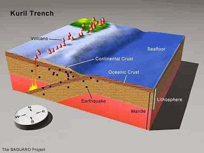
The Kamchatka Peninsula lies on the eastern edge of the Okhotsk Plate, close to its margin with the Pacific and North American Plates. The Pacific Plate is being subducted along the margin, and as it does so it passes under the southern part of the Kamchatka Peninsula. This is not a smooth process, the rocks of the two plates continuously stick together then, as the pressure builds up, break apart again, causing Earthquakes.

Simple diagram showing the subduction of the Pacific Plate beneath the Okhotsk Plate along the Kuril Trench. Auburn University.

Earthquakes along subductive margins are particularly prone to causing tsunamis, since these often occur when the overlying plate has stuck to the underlying plate, being pulled out of shape by its movement.. Eventually the pressure builds up to far and the overlying plate snaps back, causing an Earthquake and a tsunami.

Simplified graphic showing tsunami generation along a convergent margin. NASA/JPL/CalTech.

See also...

Friday, 1 August 2025

Magnitude 8.8 Earthquake off the Kamchatka Peninsula

The United States Geological Survey recorded a Magnitude 8.8 Earthquake at a depth of 20.7 km off the southeast coast of the Kamchatka Peninsula in the Russian Far East slightly before 11.25 am local time on Wednesday 30 July 2025 (slightly before 11.25 pm on Tuesday 29 July, GMT). A Magnitude of 8.8 makes this the sixth largest Earthquake ever recorded. Despite the size of this event, no casualties have been reported, although the port of Severo-Kurilsk was inundated by a 4 m wave, causing Russian authorities to evacuate the town, and tsunami warnings were triggered across the Pacific.

The approximate location of the 30 July 2025 Kamchatka Earthquake. USGS.

The Kamchatka Peninsula lies on the eastern edge of the Okhotsk Plate, close to its margin with the Pacific and North American Plates. The Pacific Plate is being subducted along the margin, and as it does so it passes under the southern part of the Kamchatka Peninsula. This is not a smooth process, the rocks of the two plates continuously stick together then, as the pressure builds up, break apart again, causing Earthquakes.

Simple diagram showing the subduction of the Pacific Plate beneath the Okhotsk Plate along the Kuril Trench. Auburn University.

Earthquakes along subductive margins are particularly prone to causing tsunamis, since these often occur when the overlying plate has stuck to the underlying plate, being pulled out of shape by its movement.. Eventually the pressure builds up to far and the overlying plate snaps back, causing an Earthquake and a tsunami.

Simplified graphic showing tsunami generation along a convergent margin.NASA/JPL/CalTech.

See also...

Friday, 14 April 2023

Eruption on Mount Shiveluch leads to widespread ash-fall on the Kamchatka Peninsula.

Mount Shiveluch, a 3283 m high stratovolcano (cone shaped volcano made up of layers of ash and lava)on the eastern Kamchatka Peninsula, underwent a major eruption on Tuesday 11 April 2023, producing an ash column about 20 km high, and ash falls over an area of about 108 000 km². The event is not thought to have led to any fatalities, but has caused significant disruption to air traffic, as well as blocking roads on the ground, and contaminating water supplies in some areas.

Fallen ash blocking a street in the village of Klyuchi on the Kamchatka Peninsula following an eruption on Mount Shiveluch on 11 April 2023. Yury Demyanchuk/Volcanology Institute of the Russian Academy of Sciences/AP.

Shiveluch is the northernmost of 30 active volcanoes on the Kamchatka Peninsula, and is a member of the Kliuchevskaya Volcano Group, in the central part of the peninsula. The volcano is thought to have begun erupting between 60 000 and 70 000 years ago, and to have undergone about 60 significant eruptive episodes during the Holocene Epoch, with particularly notable episodes between 6500 and 6400 BC, between 2250 and 2000 BC, and between 50 and 650 AD. The current eruptive episode is thought ti have begun around 900 AD.

The Kamchatka Peninsula lies on the eastern edge of the Okhotsk Plate, close to its margin with the Pacific and North American Plates. The Pacific Plate is being subducted along the margin, and as it does so it passes under the southern part of the Kamchatka Peninsula, and as it does so is partially melted by the friction and the heat of the Earth's interior. Some of the melted material then rises through the overlying Okhotsk Plate as magma and fueling the volcanoes of southern Kamchatka.

Simple diagram showing the subduction of the Pacific Plate beneath the Okhotsk Plate along the Kuril Kamchatka Trench. The Kamchatka Peninsula is at the top of the diagram. Auburn University.

See also...

Follow Sciency Thoughts on Facebook.

Follow Sciency Thoughts on Twitter


Thursday, 29 October 2020

Eruption on Mount Bezymianny in the Russian Far East.

The Tokyo Volcanic Ash Advisory Center and Kamtchatka Volcanic Eruption Response Team reported a major eruption on Mount Bezymianny, a 2882 m stratovolcano (cone shaped volcano made up of layers of ash and lava) on the central part of the Kamchatka Peninsula, which started slightly after 8.20 am local time on Thursday 22 October 2020, which produced an ash column about 9 km high, and formed a cloud roughly 100 km x 200 km in extent. This split into two parts, one of which drifted to the northwest and the other the southeast, travelling over 800 km before dispersing. The following day a satellite passing over the volcano detected a thermal anomaly which is thought likely to be the result of a lava dome forming, but there have been no further eruptions.

 
An ash column over Mount Bezymianny on the Kamchatka Peninsula on 22 October 2020. Siberian Times.

Mount Bezymianny was thought to be extinct until 1955, when it began a volcanic cycle that ended in 1956 with an explosive eruption caused the summit to collapse and created a large horseshoe-shaped crater. This has subsequently been filled in by further eruptive episodes on Bezymianny. The current summit is 2882 m high, but it is overshadowed by the nearby Kamen and Kluchevskaya volcanoes at 4579 m and 4750 m respectively. Bezymianny is thought to have formed about 4700 years ago, on the remains on an older, Pleistocene, volcano active between 11 000 and 7000 years ago. It has undergone three periods of intense activity since its formation, but was apparently inactive for about a thousand years prior to its 1955 reactivation.

Mount Bezymianny is part of the Klyuchevskoi Volcano Group in the Ust-Kamchatka (East Kamchatka) District, along with mounts Klyuchevskoi and Kamen. The Kamchatka Peninsula lies on the eastern edge of the Okhotsk Plate, close to its margin with the Pacific and North American Plates. The Pacific Plate is being subducted along the margin, and as it does so it passes under the southern part of the Kamchatka Peninsula, and as it does so is partially melted by the friction and the heat of the Earth's interior. Some of the melted material then rises through the overlying Okhotsk Plate as magma and fuelling the volcanoes of southern Kamchatka.

 
Simple diagram showing the subduction of the Pacific Plate beneath the Okhotsk Plate along the Kuril Kamchatka Trench. The Kamchatka Peninsula is at the top of the diagram. Auburn University.

See also...


Follow Sciency Thoughts on Facebook.

Follow Sciency Thoughts on Twitter.


Thursday, 8 October 2020

Investigations underway after suspected pollution incident kills thousands of marine organisms in the Russian Far East.

Investigators from the Russian Emergencies Ministry are looking for the cause of an apparent marine pollution event which has killed thousands of Marine Mammals, Fish and Invertebrates in the Russian Far East. Surfers visiting Khalaktyr Beach on Avacha Bay on the Kamchatka Peninsula began to report food-poisoning like symptoms and retina burns in early September 2020, shortly after which water in the bay was observed to turn a milky, greyish-yellow colour, and a foul smell was reported by many residents of the area. A few days after this thousands of Seals, Fish, and Invertebrates began to wash up dead along the shores of the bay.

 
Dead Fish and Invertebrates on a beach in Avacha Bay on the Kamchatka Peninsula. CNN.

Investigations by scientists based at the Kronotsky Reserve soon found that much of the seafloor of the bay was covered by dead marine life; they estimate that about 95% of organisms living in the bay have died, with only a few larger Fish and Crustaceans having apparently survived. Investigators from WWF Russia have suggested that the bay has been contaminated with a 'highly toxic transparent substance that is highly soluble in water', while preliminary results from government chemists have indicated that there are elevated levels of phenol and petroleum products in the bay.

 
The location of the Kamchatka pollution incident. Dmitry Lisitsin/Wikimapia/BBC.

The investigators have considered three possible causes of the incident so far. Firstly, the incident could have been caused by a non-Human agent, such as a bloom of toxic algae, though this has now been ruled out. Secondly, the incident could be due to a leak of fuel from the Radygino military base, but again no evidence has been found to support this. Scientists are now investigating the possibility that chemicals could have leaked from a Soviet-era waste site at Kozelsky, which is known to have been used to dispose of a variety of potentially harmful substances, including pesticides.

 
Scientists from Greenpeace collecting soil samples from beside the Nalycheva River, which empties into Avacha Bay. CNN.

See also...


Follow Sciency Thoughts on Facebook.

Follow Sciency Thoughts on Twitter


Wednesday, 15 April 2020

Aviation alart issued after eruption on Mount Klyuchevskoi.

The Kamtchatka Volcanic Eruption Response Team has issued a warning to aviation following an eruption on Mount Klyuchevskoi, a 4750, stratovolcano (cone-shaped volcano made up of successive layers of ash and lava), on the central Kamchatka Peninsula, at about 0.40 am local time on Wednesday 15 April 2020. The eruption produced an ash column that rose to a height of about 6000 meters above sealevel, and drifted about 65 km to the northeast. Smaller explosive eruptions continue on the volcano, which has been more-or-less constantly active since April 2019. 

An ash cloud above Mount Klyuchevskoi on 13 April 2020. Volcano Discovery/Kamtchatka Volcanic Eruption Response Team.

Mount Klyuchevskoi is part of the Klyuchevskoi Volcano Group in the Ust-Kamchatka (East Kamchatka) District, along with mounts Bezymianny and Kamen. The Kamchatka Peninsula lies on the eastern edge of the Okhotsk Plate, close to its margin with the Pacific and North American Plates. The Pacific Plate is being subducted along the margin, and as it does so it passes under the southern part of the Kamchatka Peninsula, and as it does so is partially melted by the friction and the heat of the Earth's interior. Some of the melted material then rises through the overlying Okhotsk Plate as magma and fuelling the volcanoes of southern Kamchatka.

Simple diagram showing the subduction of the Pacific Plate beneath the Okhotsk Plate along the Kuril Kamchatka Trench. The Kamchatka Peninsula is at the top of the diagram. Auburn University.

See also...

https://sciencythoughts.blogspot.com/2020/03/magnitude-75-earthquake-to-southeast-of.htmlhttps://sciencythoughts.blogspot.com/2019/06/raikoke-volcano-erupts-for-first-time.html
https://sciencythoughts.blogspot.com/2019/03/eruptions-on-mount-bezymianny.htmlhttps://sciencythoughts.blogspot.com/2018/11/eruption-on-mount-ebeko-produces-35-km.html
Follow Sciency Thoughts on Facebook.