Showing posts with label Macronesia. Show all posts

Friday, 10 October 2025

Batrachedra olei: A new species of Frog Moth from La Gomera, Canary Islands.

Frog Moths, Batrachedridae are a small group of largely tropical Moths, which gain their name from their resting posture, in which the front legs are held under the body while the back legs sprawl at the side, causing them to sit upright in a similar manner to a Frog. There are ten genera within the Family Batrachedridae, with the most abundant genus, Batrachedra, containing 114 known species and being found on every continent except Antarctica.

In a paper published in the journal SHILAP Revista de lepidopterología on 30 September 2025, Per Falck, an independent researcher from Neksø in Denmark describes a new species of Batrachedra, from the island of La Gomera in the Canaries. 

The new species is named Batrachedra olei in honour of the Danish lepidopterist Ole Karsholt, who Per Falck identifies as a good friend, and who helped him which both the content and the language of the research paper. The species is described from a series of specimens attracted to an actinic light (the sort of light in electric 'fly-killers') set up at locations on the island of La Gomera between 2021 and 2024.

Batrachedra olei, male, La Gomera, 11.5 mm wingspan. Falck (2025).

Specimens of Batrachedra olei range from 7.5 to 12.5 mm in wingspan, and have are white on their heads, necks, and the forepart of their thoraxes, while the hindpart of their thoraxes, their abdomens, their hindwings, and their antennae are yellowish grey. The forewings of the species are yellowish ochreous mottled with grey scales, with two indistinct, longitudinal streaks.

 Batrachedra olei, female, La Gomera, 12 mm wingspan. Falck (2025).

Adults of Batrachedra olei were found on the northern part of La Gomera between January and November, no juvenile specimens were found. The species is probably endemic to the island. Batrachedra olei is the first species discovered in the Canary Islands. There are seven previously described species of Batrachedra from Europe and North Africa, but a DNA barcode analysis recovered an unnamed species from South Africa as the closest relative to Batrachedra olei.

See also...

Tuesday, 15 August 2023

Monitoring Cetaceans in the Azores.

Gathering data on the numbers and movements of far-ranging ocean Animals such as Cetaceans is notoriously difficult, which is unfortunate, as such Animals are considered to be key indicators of the condition of marine ecosystems, with current concerns about the long-term health of the marine environment making such data particularly crucial. The Marine StrategyFramework Directive requires European Union member states with coasts to monitor the biodiversity of their territorial waters in order to maintain the marine environment. However, this does not include dedicated Cetacean surveys, due to the complexity and expense of maintaining such programs. This leaves Cetacean surveys largely in the hands of citizen scientists and commercial organizations.

The highly charismatic nature of Whales and Dolphins makes them ideal for citizen science projects, with the public often keen to take a role in their conservation. Whale watching tours have become popular tourist activities in many parts of the world in recent decades, providing both a tool for educating the public about marine ecology and an excellent opportunity for scientific programs studying Whales to piggyback onto the commercial activity. Such programs have proven particularly good for gathering long-term data on Whales within areas where tours are carried out. Whale-watching tours are therefore a cost-effective tool for monitoring Whale populations, particularly in areas where funding is limited or unavailable. Successful examples include the ORCA Survey Network operating in UK waters, the Fixed Line Transect Mediterranean monitoring Network, which works from European Atlantic and Mediterranean ferries, the CETUS project, which operates from cargo boats out of Macaronesia (the Azores, Madeira, the Canaries, and the Cape Verde islands) and mainland Portugal, and the Kakila database, which gathers data from Whale watching tours in the Caribbean. Data gathered from such sources has led to numerous publications on the distribution, movements, and habitat preferences of Cetaceans.

The Azores Islands are located in the North Atlantic Ocean at 36-41° North and 24-32° West. The archipelago is composed of nine volcanic islands organised into three groups separated by deep waters (i.e. deeper than 2000 m): the Western (Flores and Corvo), Central (Faial, Pico, Graciosa and Terceira) and Eastern groups (São Miguel and Santa Maria). The archipelago presents a well-defined oceanographic seasonality: March is usually the coldest month (average sea surface temperature 15°C), while the highest temperatures are generally reached in September (average sea surface temperature 25°C). The spring bloom is noticeable each year by the increase in chlorophyll concentrations, which drastically drop to oligotrophic conditions during summer. 

The people of the Azores have been linked to Cetaceans since the islands were first colonised in the fifteenth century, when early settlers are known to have harvested Whales stranded on beaches or found dead at sea. In the mid eighteenth century, whalers from North America began to visit the islands in pursuit of Sperm Whales, Physeter macrocephalus, often recruiting local people as crew for their vessels. The Azoreans learned the techniques used by the Americans, and adapted them to their own needs, replacing spotters mounted high upon ships with spotters at high points on land, and using these to guide small boats towards sited Whales in the same way. 

Over time the oil for which Sperm Whales was hunted was replaced by oil from other sources, making Whaling less profitable, and the practice began to die out in the 1960s. In 1982, Portugal ratified the Moratorium of theInternational Whaling Commission, and in 1986 Whaling was officially banned in all Portuguese territories, including the Azores, where the last two Sperm Wales were killed in 1987. 

The whaling industry provided the first accurate data on Whales collected in the Azores, with whalers collecting data on changes in the distribution of Whales over time, the first accurate descriptions of the Animals, and even the first records of their eating giant Cephalopods. In 1987 the government of the Azores, with support from the European Union, invited the International Fund for Animal Welfare to carry out a feasibility study on the potential for developing a Whale-watching industry in the Islands. The first tours were carried out from Pico Island in 1989, and rapidly became popular with tourists. Some the earliest recruits to the new business were former lookouts from the Whaling industry, and they were soon followed by former whalers, who worked as skippers on the new boats, brining with them their expertise in the ecology and behaviour of the Whales. In 1993 Whale-watching tours also began from São Miguel Island, with tours later starting from Faial and Terciera islands.

To date, 28 species of Whales and Dolphins have been observed around the Azores, making the islands one of the most popular Whale-watching destinations in the world. From the outset, the Whale-watching industry in the Azores was built on an ecotourism model, with regulations developed through collaboration between the tour operators, the scientific community, and the government of the Azores. The first Bienal das Baleias conference was held in Lajes do Pico in October 1998, with the various groups involved seeking to come to a consensus on further developing an ecologically friendly industry. As a consequence of this, legislation was introduced in 1999, which required the mandatory collecting of data on Whales by the tour boats, although this proved to be highly impractical, and was quickly dropped, although all parties involved agreed that a system of gathering this data was needed, both to develop the Whale-watching industry and to further the study and conservation of the Whales. 

The MONICET project grew out of a discussion at the 2006 Bienal das Baleias conference, with a scientific consortium working with three Whale-watching companies to develop a methodology for collecting data in a scientifically usable manner, and a remit to develop a database to store this data, all funded by a grant from the Azores government. 

In a paper published in the Biodiversity Data Journal on 8 August 2023, Laura González García of the  Institute of Marine Sciences at the University of the Azores, Marc Fernández of the Marine and Environmental Sciences Centre of the Agência Regional para o Desenvolvimento da Investigação Tecnologia e Inovação, and José Azevedo, also of the Institute of Marine Sciences at the University of the Azores, describe the methodology used by the MONICET project, the data gathered by that project so far, and ways in which this data might be used by researchers outside the Azores. 

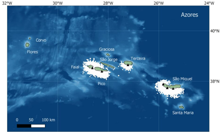
González García et al. describe eleven years of MONICET data, collected between 2009 and 2020, and provided by 11 of the 23 Whale watching companies active in the Azore, operating out of four of the nine volcanic islands which make up the Azores (Azores Experiences and Peter Whale Watch from Faial Island; Aqua  Açores and Espaço Talassa from Pico Island; Futurismo Azores Adventures, Picos de Aventura, Terra Azul, Terra do Pico and Sea Colors from São Miguel Island and Atlantiangra, Ocean Emotion and Picos de Aventura from Terceira Island). Not every company reported data every year; participitation in the project is voluntary, and data will always be accepted from any company wishing to participate. In the first year of the project only three companies reported data, while the greatest number was reached in 2019, when nine companies reported.

The Azores Archipelago, with the locations (white dots) of all the sightings recorded between 2009 and 2020 in the MONICET database. Base ports of contributing companies are indicated by black triangles. González García et al. (2023).

MONICET uses a collaborative platform to collect and disseminate data on Cetacean sightings and movements, as well as photo images used for Whale identification. The data is collected on a voluntary basis, and is available to all interested persons, including the general public. 

Whale-watching tours in the Azores typically last 2.5-3 hours, with most companies operating two tours per day, although some run three per day in the peak of the tourist season. Tours operate from São Miguel Island year-round, but from the other islands is more seasonal, typically running from May to September. In all cases, Whales are first spotted from land, with experienced spotters guiding boats to the Cetaceans. This typically results in at least one Whale encounter per trip, with boats moving to the Whales then slowing down for periods of observation. 

The data used by MONICET is typically gathered by trained guides on board the boats (often trained biologists), who record the times at which the boats leave and return to their home ports, the location of the boats throughout their voyage (recorded with a GPS system), and the time, location, and species of any Whales encountered, as well as the number of Whales, their approximate age (adults, juveniles or calves), and behaviour, as well as other data about weather, sea conditions etc. Guides are provided with annual training on data collection by MONICET.

Tourists encountering a group of Cetaceans on a Whale-watching tour in the Azores. Futurismo Azores Adventures.

During the period recorded in González García et al.'s data, 37 000 sightings were recorded of 22 Cetacean and three Turtle species, including Minke Whale, Balaenoptera acutorostrata, Sei Whale, Balaenoptera borealis, Bryde's Whale, Balaenoptera edeni, Blue Whale, Balaenoptera musculus, Fin Whale, Balaenoptera physalus, Humpback Whale, Megaptera novaeangliae, Common Dolphin, Delphinus delphis, Short-finned Pilot Whale, Globicephala macrorhynchus, Long-finned Pilot Whale, Globicephala melas, Risso's Dolphin, Grampus griseus, Killer Whale, Orcinus orca, False Killer Whale, Pseudorca crassidens, Striped Dolphin, Stenella coeruleoalba, Atlantic Spotted Dolphin, Stenella frontalis, Bottlenose Dolphin, Tursiops truncatus, Pygmy Sperm Whale, Kogia breviceps, Sperm Whale, Physeter macrocephalus, North Atlantic Bottlenose Whale, Hyperoodon ampullatus, Sowerby's Beaked Whale, Mesoplodon bidens, Blainville's Beaked Whale, Mesoplodon densirostris, True's Beaked Whale, Mesoplodon mirus, and Cuvier's Beaked Whale, Ziphius cavirostris, as well as Loggerhead Turtle, Caretta caretta, Green Turtle, Chelonia mydas, and Leatherback Turtle, Dermochelys coriacea.

One problem noted by González García et al. is that the MONICET data tends to reflect the commercial preferences of the tourist industry. Thus spotters will guide boats towards more appealing Cetaceans, such as families of Sperm Whales or active pods of Dolphins, over Beaked or diving Whales which spend little time at the surface. The data set is presumed to be good, given the training and experience of the guides, but some caution needs to be applied to sightings of more elusive Whales, as these are less often seen, and spend less time at the surface where they can be identified. 

Some types of Whale will alter their behaviour in response to the presence of boats; this is particularly true of Dolphins, which tend to break off other activities in order to investigate Human visitors. For this reason, the activity of Whales is recorded when the boats first arrive, although there is a danger that the Whales may already have been affected by the presence of earlier boats.

Whales active at the surface are more attractive to tour boats than deep diving Whales. Azores Experiences.

See also...


Follow Sciency Thoughts on Facebook.

Follow Sciency Thoughts on Twitter.


Sunday, 15 September 2019

Xenoliths in volcanic rocks from the Cape Verde Oceanic Plateau, and their implication for the structure of the Cape Verde volcanic system.

The Cape Verde Archipelago comprises ten islands and eleven seamounts arising from an oceanic plateau off the coast of West Africa. The volcanic rocks of the region are predominantly alkaline in nature, though a few of the volcanic centres are composed of felsic material. These rocks also contain a range of xenoliths, pieces of rock which are incorporated into volcanic deposits, but which are older in nature, pieces of evidence which can be crucial to the understanding of the structure and evolution of volcanic complexes.

In a paper published in the journal Minerals on 1 February 2019, Abigail Barker of the Department of Earth Sciences at Uppsala University, and the Centre of Natural Hazards and Disaster Sciences, Thor Hansteen of the GEOMAR Helmholtz Centre for Ocean Research Kiel, and David Nilsson, also of the Department of Earth Sciences at Uppsala University, describe the results of a study of xenoliths from Cadamosto Seamount and the Charles Darwin Volcanic Field of the Cape Verde Archipelago by remote operated vehicle. The Cadamosto Seamount is a roughly 2000 m high, large, mature dominantly phonolitic seamount, whereas the Charles Darwin Volcanic Field is comprised of multiple small, young mafic to phonolitic eruption centres on the Cape Verde plateau.

(a) Location map of the Cape Verde archipelago, (b) shows the Cape Verde islands and bathymetry including certain seamounts. The oceanic plateau was extensively sampled by ROV dives and dredging during the Meteor M80/3 expedition to Cape Verde in January 2010. The stars mark the locations of xenolith bearing samples featured in this study. The southwestern star depicts the Cadamosto Seamount located at the southwest of the southern chain of volcanic islands. The other star marks the Charles Darwin Volcanic Field, which lies southwest of the northern volcanic island chain, on the lower submarine flank of Santo Antão. Barker et al. (2019).

The xenoliths found by Barker et al. cam from relatively evolved lavas such as phononephelinites and phonolites. Igneous rocks are considered to be 'evolved' if they have formed from the last phases of a liquid melt that slowly cooled, so that many minerals with high crystallisation temperatures have been lost from the melt earlier; such rocks tend to be dark, dense and hard, with high calcium, magnesium, and iron contents. Such rocks are consistent with magmas with deep origins, probably in the upper oceanic lithospheric mantle, beneath the Mohorovičić discontinuity (the boundary between the Earth's crust and its mantle).

The largest xenoliths found were quite large reaching up to 5 cm in diameter, and are thought to be of sedimentary origin, with clay minerals and distinctive layering, whereas others appear to be of igneous origin, derived from earlier deep Earth processes. These are composed of plagioclase, clinopyroxene, olivine and orthopyroxene crystals of roughly similar size (100 μm).

Photomicrographs of host lavas and xenoliths from Cape Verde. (A) Feldspathoids in a lava from the Charles Darwin Volcanic Field (Sample 068DR14). (B) Phononephelinite from the Cadamosto Seamount (Sample 035ROV10). (C) Sedimentary xenolith with fine grained detrital quartz, feldspar and biotite in a clay matrix. Note the 100 μ m contact zone with the lava. (Sample 035ROV10). (D) Clinopyroxene, orthopyroxene and plagioclase bearing gabbro xenolith (Sample 068DR03). (E) Plagioclase and clinopyroxene in a gabbro xenolith (Sample 067ROV07) (XPL) (F) Olivine, clinopyroxene and plagioclase in a gabbro xenolith (Sample 068DR03) (XPL). (G) Xenolith contact with narrow rim on olivine and wide (100 μ m) rim on plagioclase (Sample 068DR14). (H) Finely recrystallized anorthoclase rim on xenolith plagioclase (Sample 068DR03) (XPL). Abbreviations: plag, plagioclase; ol, olivine; opx, orthopyroxene; cpx, clinopyroxene; di, diopside; aeg, aegirine; bt, biotite; no, nosean; ne, nepheline; le, leucite; sa, sanidine; ancl, anorthoclase. Barker et al. (2019).

Where the mineral olivine is present at the edges of xenoliths, it has begun to dissolve in the melt, then become a centre for the nucleation of clinopyroxene crystals. Barker et al. interpret this to suggest that the minerals had a surface temperature of about 1005°C, and the surrounding melt of about 1083°C, consistent with magma that was cooling during its ascent. The elemental composition of the clinopyroxene rims is similar to that of clinopyroxene in the surrounding matrix, confirming that they are derived from the melt rather than the xenoliths.
 
Barker et al. suggest that this is consistent with a model in which magmas from the lithospheric mantle rise up through oceanic crust gabbros and then shallower sedimentary rocks, collecting sedimentary xenoliths as they rise. Although these magmas are relatively well evolved, suggesting a long time interval between their formation by the melting of older rocks and their eruption at the surface, the presence of xenoliths acquired during their ascent implies that this ascent was fairly rapid, as a slow ascent would have given the xenoliths time to melt completely and be absorbed into the magma.

Schematic image of the lithospheric architecture beneath Cape Verde. The lavas crystallise clinopyroxene (cpx) in the oceanic lithospheric mantle, as they traverse the ocean crust they pick up xenoliths of ocean crust that have crystallised at crustal levels. Subsequently as magma ascent proceeds the magmas cross sediments evidenced by occasional sedimentary xenoliths, before eruption at submarine volcanic centres. Barker et al. (2019).

See also...

https://sciencythoughts.blogspot.com/2019/08/thousands-forces-to-flee-their-homes-as.htmlhttps://sciencythoughts.blogspot.com/2019/07/fifteen-dead-in-morocco-landslide.html
https://sciencythoughts.blogspot.com/2019/02/magnitude-35-earthquake-in-ifrane.htmlhttps://sciencythoughts.blogspot.com/2019/02/magnitude-43-earthquake-in-al-hoceima.html
https://sciencythoughts.blogspot.com/2019/02/collapse-at-gold-mine-feared-to-have.htmlhttps://sciencythoughts.blogspot.com/2019/02/magnitude-35-earthquake-in-figuig.html
Follow Sciency Thoughts on Facebook.

Tuesday, 20 August 2019

Thousands forces to flee their homes as wildfire sweeps across central Gran Canaria.

Around 9000 people have been forced to flee their homes as a wildfire sweeps across the northwest part of central Gran Canaria this week. The fire started near the town of Tejeda on Saturday 17 July 2019, and has so far proved impossible to bring under control. The fire has destroyed about sixty square kilometres of land cover in a mountainous region largely covered by wooded ravines, much of it in the ancient Pine forests of the Tamadaba Natural Park. There are no reports of any injuries at this time, but it is thought that several hundred homes have been destroyed.

Fire burning near El Rincón on Gran Canaria on 18 August 2019. Cabildo de Gran Canaria/AP.

The cause of the fire has not yet been determined, though local authorities have not yet ruled out the possibility that it may have been deliberately set, but it has spread rapidly due to a combination of exceptionally high temperatures in the area (over 40°C), combined with low humidity and high winds. Flames in excess of 50 m high have been reported, which helps the fire jump to new places. Pine forests are particularly prone to fires, as Pines produce a large number of long, flammable needles, which drop to the ground around the trees, causing any fires to burn rapidly and intensely.

Fire fighters trying to tackle a wildfire on Gran Canaria this week. AP.

See also...

https://sciencythoughts.blogspot.com/2017/10/series-of-earthquakes-beneath-canary.htmlhttp://sciencythoughts.blogspot.co.uk/2013/12/magnitude-54-earthquake-off-coast-of-el.html
http://sciencythoughts.blogspot.co.uk/2013/08/the-floating-stones-of-el-hierro.htmlhttp://sciencythoughts.blogspot.co.uk/2013/03/earthquake-of-coast-of-el-hierro.html
http://sciencythoughts.blogspot.co.uk/2012/07/fresh-volcanic-activity-on-el-hierro.htmlhttp://sciencythoughts.blogspot.co.uk/2011/10/ongoing-volcanic-activity-on-el-hierro.html
Follow Sciency Thoughts on Facebook.

Tuesday, 6 November 2018

Glaresis hespericula: A new species of Scarab Beetle from the Cape Verde Islands.

The Glaresidae are a family of small and rather uniform Scarab Beetles thought to be the sister group to all other Scarabs. They have a long fossil record, with seven known Mesozoic species in three separate genera. All modern members of the group are placed in a single genus, Glaresis, which currently contains 82 species, found on every major land-mass except Antarctica and Australia.

In a paper published in the journal ZooKeys on 23 October 2018, David Král and Lucie Hrůzová of the Department of Zoology at Charles University, describe a new species of Glaresis from Boa Vista Island in the Cape Verde group.

The species is named Glaresis hespericula, where ‘hespericula’ means a juvenile Hesperid. It is described from two specimens, one male and one female, collected from near Praia de Chavez. Both are robust, golden Beetles with a fine covering of short hairs. The male is 4.2 mm in length and the female 4.3 mm.

Glaresis hespericula, (1) male in dorsal view, (2) female in ventral view. Král & Hrůzová (2018) 

See also...

https://sciencythoughts.blogspot.com/2018/07/beauveria-majiangensis-new-species-of.htmlhttps://sciencythoughts.blogspot.com/2018/06/macrocheles-kekensis-new-species-of.html
https://sciencythoughts.blogspot.com/2017/10/eurypeza-aurora-new-species-of-scarab.htmlhttps://sciencythoughts.blogspot.com/2017/10/lamellothyrea-isimangalis-new-species.html
https://sciencythoughts.blogspot.com/2017/09/pegylis-majori-new-species-of-scarab.htmlhttps://sciencythoughts.blogspot.com/2017/07/electraesalopsis-beuteli-new-species-of.html
Follow Sciency Thoughts on Facebook.