Monday, 9 February 2015

Asteroid 2015 BF92 passes the Earth.

Asteroid 2015 BF92 passed by the Earth at a distance of 3 267 000 km (8.5 times the average distance between the Earth and the Moon, or 2.2 % of the average distance between the Earth and the Sun), slightly before 10.10 pm GMT on Saturday 7 February 2015. There was no danger of the asteroid hitting us, though had it done so it would have presented minor threat. 2015 BF92 has an estimated equivalent diameter of 30-92 m (i.e. it is estimated that a spherical object with the same volume would be 30-92 m in diameter), and an object towards the upper end of this range would either explode very close to the ground with an energy of about 30 megatonnes of TNT (about 1750 times the energy of the Hiroshima bomb) or directly impact the ground, causing devastation over a wide area and creating a crater almost a kilometer across.

The calculated orbit of 2015 BF92. JPL Small Body Database.

2015 BF92 was discovered on 19 January 2015 (nineteen days before its closest approach to the Earth) by the University of Hawaii's PANSTARRS telescope on Mount Haleakala on Maui. The designation 2015 BF92 implies that it was the 2306th asteroid (asteroid F92) discovered in the second half of January 2015 (period 2015 B).

2015 BF92 has an 848 day orbital period and an eccentric orbit tilted at an angle of 6° to the plane of the Solar System, which takes it from 0.82 AU from the Sun (i.e. 82% of the average distance at which the Earth orbits the Sun) to 2.68 AU from the Sun (i.e. 268% of the average distance at which the Earth orbits the Sun, considerably more than the disctance at which the planet Mars orbits the Sun). It is therefore classed as an Apollo Group Asteroid (an asteroid that is on average further from the Sun than the Earth, but which does get closer). This means that close encounters between the asteroid and Earth are extremely common, with the next predicted in January 2140.

See also...

Asteroid 2009 DT10 passed by the Earth at a distance of 8 202 000 km (21.34 times the average distance between the Earth and the Moon, or 5.5 % of the average distance between the Earth and the Sun), slightly after 4.14 am GMT on Saturday 7 February...


Asteroid 2015 BX509 passes the Earth.   Asteroid 2015 BX509 passed by the Earth at a distance of 13 610 000 km (35.48 times the average distance between the Earth and the Moon, or 9.1% of the average distance between the Earth and the Sun), slightly before 3.25 pm GMT on Thursday 5 February...


Asteroid 2015 BH514 passed by the Earth at a distance of 8 509 000 km (22.53 times the average distance between the Earth and the Moon, or 5.6 % of the average distance between the Earth and the Sun), slightly before 8.40 pm GMT on Wednesday 4...


Follow Sciency Thoughts on Facebook.

Series of Earthquakes of the south coast of Cornwall.

The British Geological Survey recorded a series of small Earthquakes off the south coast of Cornwall (about 45 km to the southeast of Falmouth) on Saturday 7 February 2015. The had a Magnitude of 1.2 and occurred at about 6.12 am GMT, the second had a Magnitude of 1.7 and occurred at about 6.27 am GMT and the third a Magnitude of 1.3 and occurred at about 6.32 am. All were at a depth of about 3 km. Quakes of this size do not present any threat to human life or property, and this far offshore it is highly unlikely that they were felt by anyone.

The approximate location of the 7 February 2014 Earthquakes. Google Maps.

Earthquakes become more common as you travel north and west in Great Britain, with the west coast of Scotland being the most quake-prone part of the island and the northwest of Wales being more prone  to quakes than the rest of Wales or most of England. However, while quakes in southern England are less frequent, they are often larger than events in the north, as tectonic presures tend to build up for longer periods of time between events, so that when they occur more pressure is released.

The precise cause of Earthquakes in the UK can be hard to determine; the country is not close to any obvious single cause of such activity such as a plate margin, but is subject to tectonic pressures from several different sources, with most quakes probably being the result of the interplay between these forces.

Britain is being pushed to the east by the expansion of the Atlantic Ocean and to the north by the impact of Africa into Europe from the south. It is also affected by lesser areas of tectonic spreading beneath the North Sea, Rhine Valley and Bay of Biscay. Finally the country is subject to glacial rebound; until about 10 000 years ago much of the north of the country was covered by a thick layer of glacial ice (this is believed to have been thickest on the west coast of Scotland), pushing the rocks of the British lithosphere down into the underlying mantle. This ice is now gone, and the rocks are springing (slowly) back into their original position, causing the occasional Earthquake in the process.

(Top) Simplified diagram showing principle of glacial rebound. Wikipedia. (Bottom) Map showing the rate of glacial rebound in various parts of the UK. Note that some parts of England and Wales show negative values, these areas are being pushed down slightly by uplift in Scotland, as the entire landmass is quite rigid and acts a bit like a see-saw. Climate North East.


Glacial rebound seems an unlikely cause of Earthquakes beneath the English Channel to the south of Cornwall, an area that was never glaciated, but this is not entirely the case. The northwest of Scotland is rising up faster than any other part of the UK, but the Earth's crust onland in the UK is fairly thick, and does not bend particularly freely, whereas the crust beneath the Channel is comparatively thin and more inclined to bend under stress. Thus uplift in Scotland can cause the entire landmass of Great Britain to pivot, causing movement in the rocks beneath the Channel.

See also...

The British Geological Survey recorded a Magnitude 1.8 Earthquake at a depth of 8 km under the English Channel, roughly 60 km o the southeast of Falmouth in Cornwall, slightly before 11.15 am British Summertime...

Walkers between Bowleaze Cove and Redcliff Point, near Weymouth in Dorset, reported the appearance of a landslip on the cliffs on Thursday 14 March 2013, with a section of the cliff 50 m long sinking 2 m from the rest...

On Sunday 30 December 2012, slightly before 3.00 pm GMT, the British Geological Survey recorded a Magnitude 1.3 Earthquake 7 km beneath the Somerset town of Highbridge, roughly 15 km south of...


Follow Sciency Thoughts on Facebook.

Dwarf Crocodile remains from the Oligo–Miocene of northwestern Queensland.


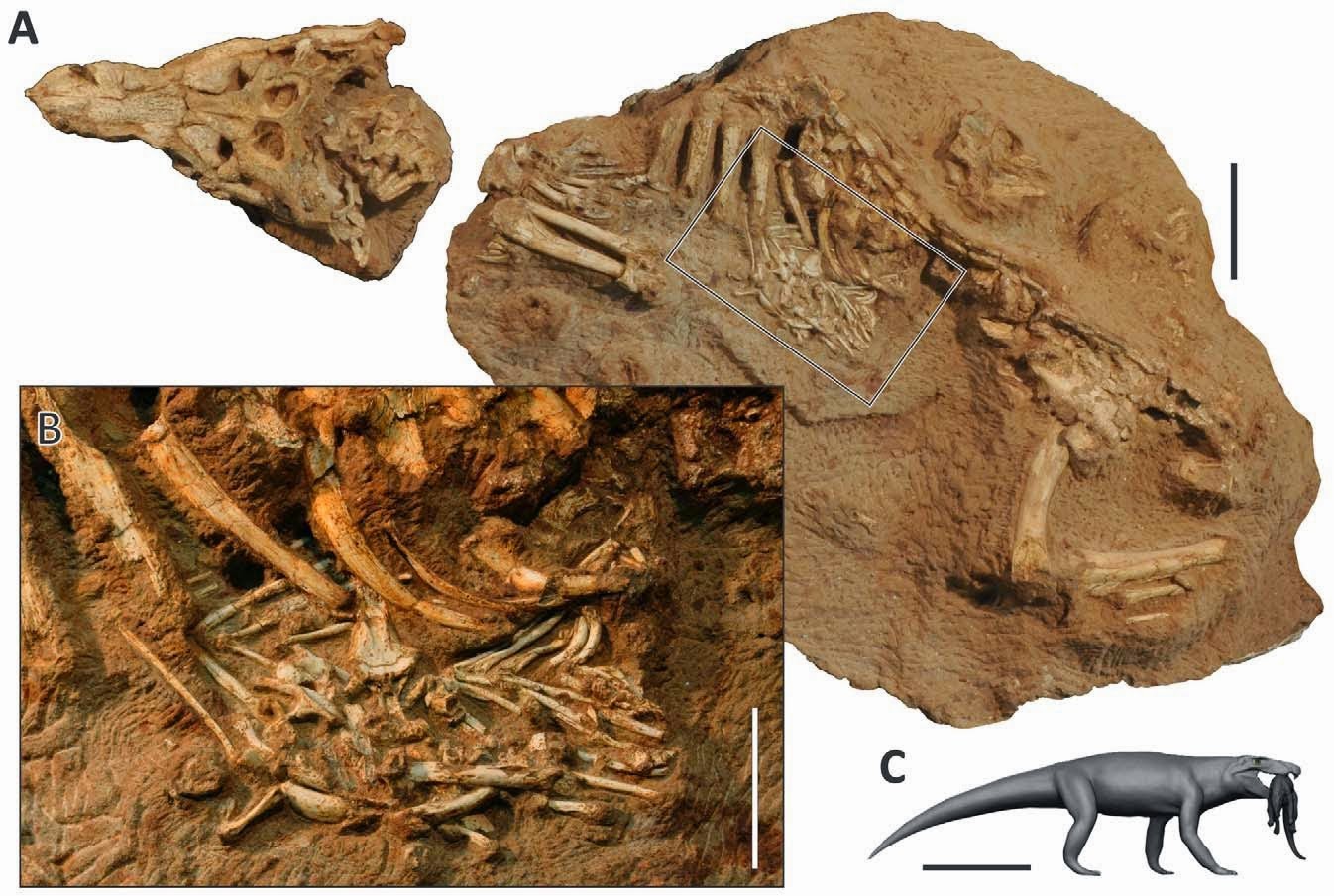
The Mekosuchine Crocodile Mekosuchuswhitehunterensis was described from Late Oligocene deposits exposed at the White Hunter Site in the Riversleigh World Heritage Area innorthwestern Queensland. It is interpreted to have been largely terrestrial, and to have been a dwarf species reaching maturity at little over a meter in length. However dwarfism is hard to diagnose in fossil Crocodilian species, as the animals grow throughout their entire lives, only slowing their growth rate when they reach maturity, and because small Crocodillian species tend to be essentially similar to juveniles of larger species.

In a forthcoming paper in the journal Acta Palaeontologica Polonica, available online from 16 January 2015, Michael Stein, Michael Archer and Suzanne Hand of the School of Biological, Earth and Environmental Sciences at the University of New South Wales describe additional material assigned to Mekosuchus whitehunterensis from the Early Miocene Price is Right Site and Late Oligocene Hiatus and LSO sites, also in the Riversleigh World Heritage Area.

The original material from the White Hunter Site comprised entirely cranial material. The new material from the Price is Right Site comprises a left maxilla and dentary (upper and lower jaw bones) which appear to belong to the same species, as well as a series of five associated cervical vertebrae. The material from the Hiatus Site comprises two vertebrae which appear to be from the same species as those at the Price is Right Site, while the LSO site material comprises a single vertebra, again apparently of the same species.

Rostra of Mekosuchine Crocodile Mekosuchus whitehunterensis.(A) Left maxilla in buccal (A1) and ventral (A2) views. (B) Left dentary in lingual (B1), dorsal (B2), and buccal (B3) views. Scale bars 5 cm. Stein et al. (2015).

Vertebrae are much more useful in assessing the maturity of a Crocodilian than cranial material, as the neurocentral suture closes (mineralizes) in mature individuals. The new vertebrae appear to come from a mature individual, and have a mean anterioposterior length (front-to-back length, thickness) of 19.3 mm. The most complete known skull of Mekosuchus whitehunterensis is about 10 cm in length, which combined with the proportions of the vertebrae suggest a mature individual measuring about 60 cm, considerably smaller than the smallest modern Crocodilians, Osteolaminus and Paleosuchus, both of which typically exceed a meter in length at maturity.

Vertebrae of Mekosuchine Crocodile Mekosuchus whitehunterensisin left (A1–H1) and right (A2–H2) views. (A) Axis vertebra. (B) Third cervical vertebra. (C) Fourth cervical vertebra. (D) Sixth cervical vertebra. (E) Ninth cervical vertebra. (F) Third thoracic vertebra. (G) Third cervical vertebra. (H) Eighth cervical vertebra. Arrows indicate extent of the neurocentral suture. Scale bars 2 cm. Stein et al. (2015).

The cervical vertebrae show significantly enlarged muscle attachments, suggesting that the living animal had powerful neck muscles. This has implications for the feeding strategy of the living animal. Modern Crocodiles remove meat from prey animals in two ways. Firstly they body role, taking a firm grip of their prey they rotate their entire bodies in order to tear digestible pieces from the prey. However this strategy is seldom employed by small Crocodilians, which lack the mass use this strategy effectively. It is also a feeding method best suited to an aquatic environment, where the water cushions the body from any damage, and could be rather more risky in a terrestrial environment (where Mekosuchus whitehunterensisis thought to have fed) as friction with the ground could potentially lead to damage to the body or limbs. Secondly Crocodiles can remove meat from a prey animal by vigorously shaking their heads in a manner similar to a Dog. This is a strategy of limited usefulness in an aquatic environment, where the prey is likely to simply move with the head, but can be very effective on dry land, where the prey is held down to some extent by gravity and experiences friction with the ground. The enlarged neck muscles of Mekosuchus whitehunterensis would seem suitable for such a feeding method, supporting the idea that it hunted or scavenged away from the water.

See also…

http://sciencythoughts.blogspot.co.uk/2014/12/a-baurusuchidcrocodyliforme-with.htmlA Baurusuchid Crocodyliforme with preserved stomach contents from the Late Cretaceous of Brazil.                                                                     The Adamantina Formation from the Late Cretaceous of southern Brazil produces a wide variety of Crocodyliformes, including semi-aquatic...
The Tethysuchians were a group of largely marine Crocodyliforms that are reasonably well known from the Middle and Late Cretaceous, with one group, the Dyrosauridae surviving the End Cretaceous extinction...
The Rosso Ammonitico Veronese is a red nodular limestone found on the Trento Plateau in northern Italy, and Middle to Late Jurassic in age. It is noted for its numerous Ammonite fossils, but also produces occasional Marine Reptiles, notably Thalattosuchian Crocodylomorphs and Plesiosaurians. The earliest recorded discovery of such a Reptile is a Crocodylian...

Follow Sciency Thoughts on Facebook.

A new species of Dorstenia from the Democratic Republic of Congo.

Dorstenias are tropical herbaceous plants or small shrubs found predominantly in the Africa and the Americas, but with one species from Asia. They are mostly upright succulent plants (i.e. plants that store water in fleshy leaves and stems to help them survive periods of drought) which produce sticky latex to deter consumption. They produce seeds in drupes (fleshy fruit that contain a single large seed) which dry out then expel their seeds explosively.

In a paper published in the journal PhytoKeys on 24 October 2014, Miguel Leal of the Wildlife Conservation Society describes a new and somewhat unusual Dorstenia from the Luama Wildlife Reserve in eastern Democratic Republic of Congo.

The new species is named Dorstenia luamensis, meaning ‘from Luama’ in reference to the locality where it was discovered. While immediately recognisable as a Dorsteniafrom its inflorescence, it has an unusual morphology, lacking succulent leaves and stems and growing hanging from cliffs rather than upright on the ground, and does not produce any latex.

A population of Dorstenia luamensis on a vertical rock face. Leal (2014).

The plants were found only in a few populations in a very limited area, and as such the species is considered to be Endangered under the terms of the International Union for the Conservation of Nature’s Red List of ThreatenedSpecies.

See also…

Shrews (Soricidae) are small insectivorous or omnivorous Mammals found across much of the world, the only major landmasses from which they are absent being Australia, New Zealand and New Guinea, though they are restricted to the northwest of South America, suggesting they are recent arrivals in that continent...

http://sciencythoughts.blogspot.co.uk/2013/08/two-new-species-of-parasitic-nematode.htmlTwo new species of parasitic Nematode from the Democratic Republic of Congo.        Nematodes are probably the most numerous and specious group of animals on Earth, though relatively few species have actually been described. The title of...

Follow Sciency Thoughts on Facebook.

Asteroid 2009 DT10 passes the Earth.

Asteroid 2009 DT10 passed by the Earth at a distance of 8 202 000 km (21.34 times the average distance between the Earth and the Moon, or 5.5 % of the average distance between the Earth and the Sun), slightly after 4.14 am GMT on Saturday 7 February 2015. There was no danger of the asteroid hitting us, though had it done so it would have presented significant threat. 2009 DT10 has an estimated equivalent diameter of 52-160 m (i.e. it is estimated that a spherical object with the same volume would be 52-160 m in diameter), and an object towards the upper end of this range would be expected to be capable of passing through the atmosphere reasonably intact, impacting the ground in an explosion equivalent to about 80 megatonnes of TNT (roughly 4700 times the energy of the Hiroshima bomb) and creating a crator about 2.5 km in diameter. Such an event would cause devastation over a wide area, and could cause climatic problems for decades.

 The calculated orbit of 2009 DT10. JPL Small Body Database.

2009 was first observed by Siding Spring Observatory on 21 February 2009. The designation 2009 DT10 indicates that it was the 269th asteroid (asteroid T10) discovered in the second half of February 2009 (peroid 2009 D).

2009 DT10 has a 1094 day orbital period and an eccentric orbit tilted at an angle of 3.9° to the plane of the Solar System, which takes it from 0.79 AU from the Sun (i.e. 79% of the average distance at which the Earth orbits the Sun) to 3.37 AU from the Sun (i.e. 3.37% of the average distance at which the Earth orbits the Sun, considerably more than twice the disctance at which the planet Mars orbits the Sun). It is therefore classed as an Apollo Group Asteroid (an asteroid that is on average further from the Sun than the Earth, but which does get closer). This means that close encounters between the asteroid and Earth are extremely common, with the last having occurred in February 2012 this year and the next predicted in January 2018.

See also...

http://sciencythoughts.blogspot.co.uk/2015/02/asteroid-2015-bx509-passes-earth.htmlAsteroid 2015 BX509 passes the Earth.   Asteroid 2015 BX509 passed by the Earth at a distance of 13 610 000 km (35.48 times the average distance between the Earth and the Moon, or 9.1% of the average distance between the Earth and the Sun), slightly before 3.25 pm GMT on Thursday 5 February 2015. There...

Asteroid 2015 BH514 passed by the Earth at a distance of 8 509 000 km (22.53 times the average distance between the Earth and the Moon, or 5.6 % of the average distance between the Earth and the Sun), slightly before 8.40 pm GMT on Wednesday 4...
 

Asteroid (357439) 2004 made a close approach to the Earth on Monday 26 January 2015, enabling scientists at NASA's Deep Space Network antenna at...
 Follow Sciency Thoughts on Facebook.
 

One killed by landslide in Chittagong Hills, Bangladesh.

One man has been killed and another four injured following a landslide at a construction site in the Siddique Nagar area of Bandarban Sadar, in the Chittagong Hills of Bangladesh, at about 11.40 am local time on Sunday 8 February 2015. The dead man has been named as Mohammad Jakaria, 24, from Teknaf in Cox's Bazar, who was killed immediately when a section of hillside collapsed onto the men. The other men were taken to the Bandarban Sadar Hospital for treatment; one was later moved to the Chittagong Medical College Hospital due to the seriousness of his condition. 

The scene of the 8 February 2015 Chittagong Hills landslide. The Daily Star.

The men are understood to have been working on a hill cutting at the time of the incident. Locals reported that they were employed by a contractor who had been asked to make a 3 m cutting into the slope, but had made a much larger cutting, around 12 m, which contravenes local legeslation, and that they had complained about the risk this presented to both to local residents and pupils at a nearby primary school.

The approximate location of the 8 February 2015 Chittagong Hills landslide. Google Maps.

See also...

Two people are known to have died and around 40 more are missing following a landslide at a jade mine at Hpakant in Kachin Province in...
 
http://sciencythoughts.blogspot.co.uk/2014/05/seven-members-of-one-family-killed-by.htmlSeven members of one family killed by landslide in Assam State, India.                           Seven members of a single family have been killed by a landslide that struck their home in the village of Satkoragool in the Karimganj District of Assam State...
http://sciencythoughts.blogspot.co.uk/2013/07/two-women-killed-by-landslide-in.htmlTwo women killed by landslide in Chittagong, Bangladesh.                                                            Two women were killed in the Lalkhan Bazar area of Chittagong City, Bangladesh, when a 6 m chunk of soil fell onto their home between 4.00 and 5.00 am local...
Follow Sciency Thoughts on Facebook.

Sunday, 8 February 2015

Evacuations ordered after violent eruptions on Mount Fuego in Guatemala.

The Instituto Nacional de Sismologia, Vulcanologia, Meteorologia, e Hidrologia in Guatemala has ordered an evacuation of communities close to Mount Fuego, an active volcano in the south of the country, sharply increased its level of activity on Saturday 7 February 2015. The volcano began its current active phase in 2002, and has had a number of small eruptive episodes already this year, but this is he first time that Guatemalan authorities have felt the need to order an evacuation since September 2012. A number of explosions have been reported as well as an ash column rising 4.8 km above the summit of the volcano (5.6 km above sea level) and drifting to the southwest. Ash falls have been reported over a wide area, and the Dirección General de Aeronautica Civil has temporarily ordered a closure of the countries main airport. Small pyroclastic flows have also been reported near the summit of the volcano.

Falling ash from Fuego on a street market in Guatemala. Prensa Libre.

Fuego has been more-or-less constantly active at some level since records in the area began (circa 1524). It forms part of La Horqueta volcanic complex, which also includes the Acatenango volcano to the north, a complex volcano with at least five separate vents, the complex siting on the site of the ancient Meseta volcano, which is thought to have collapsed following a major volcanic episode about 8500 years ago, causing a debris flow that reached the sea, 50 km away.

The approximate location of Mount Fuego. Google Maps.

The volcanoes of Guatemala, and Central America in general, are fed by the subduction of the Cocos Plate beneath the Caribbean Plate along the Middle American Trench, which runs roughly parallel to the southwest coast of the isthmus. As the Cocos Plate sinks into the Earth, it passes under Central America, which lies on the western margin of the Caribbean Plate. As this happens it is heated by the friction and the heat of the planet's interior, causing the sinking plate to partially melt. Some of the melted material then rises through the overlying Caribbean Plate as magma, fueling the volcanoes of Central America.

See also...

The United States Geological Survey Recorded a Magnitude 5.0 Earthquake at a depth of 74.2 km in the east of Esculinta Department in southern Guatemala...


Six people are known to have died, three more are missing and seven are being treated for a variety of injuries following a landslide in the village of Joya Grande in the Department of Huehuetenango in...


Around 3000 people may need to evacuated from villages close to...


Follow Sciency Thoughts on Facebook.