
The United States Geological Survey
recorded a Magnitude 5.9 Earthquake at a depth of 10.0 km roughly 57 km to the northeast of the city of Hashtrud in East Azerbaijan Province,
Iran, slightly after 2.15 am local time on Friday 8 November 2019 (slightly after 10.45 pm on Thursday 7 November
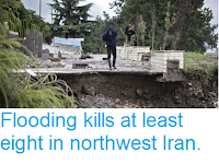
GMT). The Earthquake is reported to have killed at least five people, with more than 330 people having been injured. Three villages close to the epicentre of the event are described as having been 'completely destroyed' in local media reports, and the event was felt across northwest Iran.

A collapsed building covering a car in the village of Varankesh East Azerbaijan Province, Iran. CNN.
Iran is situated on the southern margin of the Eurasian Plate.
Immediately to the south lies the Arabian Plate, which is being pushed
northward by the impact of Africa from the south. This has created a
zone of faulting and fold mountains along the southwest coast of the
country, known as the Zagros Thrust Belt, while to the northeast of this
the geology is dominated by three large tectonic blocks, the Central
Iran, Lut and Helmand, which move separately in response to pressure
from the south, stretching and compressing the rock layers close to the
surface and creating frequent Earthquakes, some of which can be very
large.

The
location of the 8 November 2019 East Azerbaijan Province Earthquake. Contour
lines show rates of movement during the quake, the red line is a
boundary between two tectonic plates, in this case the Anatolia and Eurasian plates. USGS.
To the northeast of this the geology is dominated by three large
tectonic blocks, the Central Iran, Lut and Helmand, which move
separately in response to pressure from the south, stretching and
compressing the rock layers close to the surface and again creating frequent
Earthquakes.

The movement of the Arabian Plate and extent of the Zagros Thrust Belt. Rasoul Sorkhabi/Geo ExPro.
The population of Iran is particularly at risk from Earthquakes as,
unlike most other Earthquake-prone nations, very few buildings in the
country are quake-resistant. The majority of residential buildings in
Iran are made of mud-brick, a building material particularly vulnerable
to Earthquakes as the bricks often liquefy, trapping people inside and
quickly asphyxiating them with dust. This is particularly dangerous at
night when the majority of people are inside sleeping.
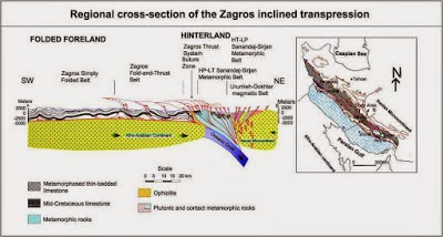
Section through the Zagros Fold Belt. Sarkarinejad & Azizi (2007).
See also...


Follow Sciency Thoughts on Facebook.