
The United States Geological Survey
recorded a Magnitude 6.1 Earthquake at a depth of 10 km, in Sainyabuli Province, Laos, close to the border with Thailand, at about 6.50 am local time on Thursday 21 November 2019 (about 11.50 pm on Wednesday 20 November, GMT). There have been no reports of any casualties associated with this event, but it causes minor damage to several buildings in Thailand and was felt across northern Laos and Thailand.

A collapsed ceiling at a Border Patrol Police building in Thailand. Rarinthorn Petcharoen/Bangkok Post.
Although Laos is located far from any active tectonic plate boundaries, it is still effected by the collision between the Indo-Australian and Eurasian Plates, and the northern part of the country is a recognised area of Earthquake hazards. The area is located on the northern part of the a breakaway part of
the Eurasian Plate which is being pushed southward by the impact of India into Eurasia. This impact is causing uplift in the Himalayas and pushing the Tibetan block to the east, which in turn forces the Sunda Plate and South China Block to the southeast.

Tectonic map of Asia, showing relationships between the India–Asia
collision, escape of Indonesian and South China blocks seaward, and
extension from Siberia to the Pacific margin. (Note also the opening of
back-arc basins including the Sea of Japan and the South China Sea, and
extension in the Bohai Basin and eastern part of the NCC.) The North
China Craton is also strongly influenced by Pacific and palaeo-Pacific
subduction, perhaps also inducing extension in the eastern NCC. The
palaeo Pacific and Pacific subduction zones developed in the Mesozoic,
and also contributed to the hydration of the subcontinental lithospheric
mantle beneath the NCC. Kusky et al. (2007).
To the south Indo-Australian Plate, which underlies the Indian Ocean to the west of
Sumatra, is being subducted beneath the Sunda Plate along
the Sunda Trench, passing under Sumatra and Java, where friction between the two
plates can cause Earthquakes. As the Indo-Australian Plate sinks further
into the Earth it is partially melted and some of the melted material
rises through the overlying Sunda Plate as magma, fuelling the volcanoes
of Sumatra and Java.
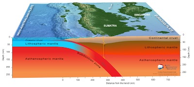
The Subduction zone beneath Sumatra. NASA/Earth Observatory.
The two plates are not directly impacting one-another here, as occurs in the subduction zones along
the western margins of North and South America, but at a steeply
oblique angle. This means that as well as the subduction of the
Indo-Australian plate beneath the Sunda, the two plates are also moving
past one-another. This causes rifting within the plates, as parts of
each plate become stuck to the other, and are dragged along in the
opposing plate's direction. The most obvious example of this is the
Sumatran Fault, which runs the length of Sumatra, with the two halves of
the island moving independently of one-another. This fault is the cause
of most of the quakes on the island, and most of the island's volcanoes
lie on it.

The movement of the tectonic plates around Sumatra. NASA/Earth Observatory.
To the east and northeast the Burma (or Burmese) Plate, a small tectonic plate which underlies part of the eastern Indian Ocean and the
western part of Sumatra, is being pushed northward
relative to the Eurasia and the Sunda Plate by the northward movement of the Indian Plate. As these larger plates move together the
Burma Plate is being squeezed and fractured, with a major fault line,
the Kabaw Fault, having formed across much of the north of the country,
along which the Burma Plate is slowly splitting. Most Earthquakes in the
region are caused by movement on this fault.

Witness
accounts of Earthquakes can help geologists to understand these events,
and the structures that cause them. The international non-profit
organisation Earthquake Report is interested in hearing from people who
may have felt this event; if you felt this quake then you can report it to Earthquake Report here.

The
location of the 21 November 2019 Sainyabuli Province Earthquake. Contour
lines show rates of movement during the quake, the red line is a
boundary between two tectonic plates, in this case the Indo-Australian and Sunda plates. USGS.
See also...


Follow Sciency Thoughts on Facebook.