Showing posts with label Gulf of Mexico. Show all posts

Thursday, 2 January 2025

Two new species of Solenogastre from the Gulf of Mexico.

Solenogastres (Aplacophora) are a unique group of Molluscs which have vermiform bodies (i.e. are 'worm-shaped'), lack shells (although some have calcareous sclerites), and have a greatly reduced mantle and foot. This anatomy long led evolutionary biologists to conclude that Solenogastres represent a 'primitive' state for Molluscs, and they were interpreted as an early-branching clade with a sister-group relationship to all other Molluscs. Modern genetics-based taxonomy has reviewed this slightly, showing that the Solenogastres are the sister group to the Chitons (Polyplacophora), a superficially Gastropod-like group which have segmented shells and lack internal torsion, with these two combined forming the out-group to all other Molluscs. There are currently about 300 species of described Solenogastres, although it is thought that their true diversity is much higher. Solenogastres are notoriously difficult to locate and identify, particularly for non-specialists. Most species are less than 5 mm in length, many live infaunally in marine sediments, some of them on the oceans deep-abyssal plains, while others live epifaunally or on the bodies of Corals of Hydrozoans.

In a paper published in the journal ZooKeys on 31 September 2024, Carmen Cobo of the Department of Invertebrate Zoology at the Smithsonian National Museum of Natural History, William Farris, Chandler Olsen, and Emily McLaughlin, of the Department of Biological Sciences at the University of Alabama, and Kevin Kocot, also of the Department of Biological Sciences at the University of Alabama, and of the Alabama Museum of Natural History, describe two new species of Solenogastre from the Gulf of Mexico, collected from Autonomous Reef Monitoring Structures.

Autonomous Reef Monitoring Structures are standardised structures used to sample marine life on reefs. They are made up of multiple stacked flat plates which mimic a complex reef-environment. These structures are screwed onto a reef-surface, where they attract settling benthic organisms, and can be collected at a later date, without damaging the overall reef-structure. The Autonomous Reef Monitoring Structures examined by Cobo et al. where placed on reefs in the Gulf of Mexico by the Research Vessel Point Sur in May 2019, and collected in August 2021.

One of the Autonomous Reef Monitoring Structures deployed in the Gulf of Mexico from which Solenogasters were collected. Cobo et al. (2024).

The first new species described by Cobo et al. is placed within the genus Dondersia and given the specific name tweedtae, in honour of marine biologist Sarah Tweedt, who collected the specimens used in the study, for her outstanding work studying invertebrate biodiversity using Autonomous Reef Monitoring Structures. It is described from a single specimen from an Autonomous Reef Monitoring Structure deployed at a depth of 82 m.

The single known specimen of Dondersia tweedtae is about 14 mm in length and 0.55 mm wide at the mid-body, although in life the Animal expanded and contracted its body as it moved. It is bright pink in colour, with a dorsal keel made up of seventeen distinct bright yellow lobes. It has a smooth appearance, with a covering of scale-like sclerites, of which there are three different types. 

Habitus of Dondersia tweedtae. (A) Field photographs of the holotype showing the contractions and extension range (usnm 1718003). (B) Photograph of the holotype preserved in ethanol B’ detail of the lobes of the dorsal keel. Star indicates the anterior end of the Animal. Cobo et al. (2024).

The second new species is placed within the genus Eleutheromenia and given the specific name bullescens, where 'bullescens' derives from the Latin 'bullescere', meaning 'to bubble', in reference to the protrusions on the dorsal keel of the Animal. The species is described from two specimens collected from an Autonomous Reef Monitoring Structure placed at a depth of 82 m within the Gulf of Mexico, about 100 km to the west of the structure from which Dondersia tweedtae was collected.

The specimens of Eleutheromenia bullescens are 10-12 mm in length and 0.5-1.0 mm in width at their midsections, although again, in life these Animals expanded and contracted their bodies as they moved. They were light orange in colour, with a dorsal keel made up of numerous lobes, and a covering of spines formed from hollow sclerites, some of which are hook- or harpoon-shaped.

Habitus of Eleutheromenia bullescens. (A), (A’) Field images of the Holotype (USNM 1718004) (B), (B’) Field images of the paratype (USNM 1718005). (C( Paratype in 95% ethanol. (D) Detail of the dorsal lobes in the holotype (decalcified mid-body region). Images were captured using Olympus DSX100 optical microscope with anti-halation and fast HDR adjustments; brightness 0016 to 0022, texture 50-71, contrast 36-50. Star indicates the anterior end of the animal. Arrow indicates detached lobes and their 'pedunculi'. Cobo et al. (2024).

Both Dondersia tweedtae and Eleutheromenia bullescens have distict dorsal keels, something not generally found in Solenogastres, combined with brighter colouration than is typical for the group. Despite this, they were confirmed by both morphological and genetic analysis to be members of distantly related groups. Furthermore, the structures of the dorsal keels are quite different in the two species, strongly suggesting that this is a result of convergent evolution, rather then recent common ancestry. the reason for this is unclear, though Cobo et al. note that in the absence of shells, Solanogastres have adopted a range of other defence strategies, including mimicry, crypsis, autotomy, production of defensive chemicals, or the retention of exogenous biochemically active compounds and cnidocytes (the stinging cells of Cnidarians) from their prey. They further note that the lobes which make up the dorsal keel of Eleutheromenia bullescens contained a number of cells which appeared to be derived from another organism, including one possible cnidocyte.

See also...

Friday, 14 April 2023

Examining the impact of the Palaeocene–Eocene Thermal Maximum on sedimentation in the Gulf of Mexico.

Roughly 56 million years ago, global temperatures abruptly rose by 5-9°, leading to profound environmental changes across the planet, an event known as the Palaeocene–Eocene Thermal Maximum. This event was marked (and probably caused by) a sharp rise in atmospheric carbon dioxide, something marked in the rock record by a 3.0‰ negative carbon isotope excursion (three parts per thousand drop in the proportion of carbon¹³ to total carbon), which developed over a period of less than 5000 years. Three main stages to this negative carbon isotope extension have been detected; the onset, during which the proportion of carbon¹³ dropped from the pre-excursion level to the excursion level; the body, during which the proportion of carbon¹³ remained steady at the new, lower level; and the recovery, during which the proportion of carbon¹³ returned to the pre-excursion level.

This interval was also marked by a dramatic increase in the prevalence of the Dinoflagellate cyst Apectodinium spp., and a widespread dissolution of carbonates (a sign that the sea had become slightly acidic due to the higher atmospheric carbon dioxide levels). The negative carbon isotope excursion has been detected in a wide range of sedimentary setting, from continental interiors to ocean basins, although its cause is still debated. It is generally accepted that the rise in atmospheric carbon dioxide, combined with the drop in the proportion of carbon¹³, is indicative of the atmosphere receiving a sudden, and very large, input of carbon¹³-depleted carbon dioxide, with the most popular explanations for this being a volcanic source or a sudden increase in the proportion of carbon dioxide being released from land Plants and soils (this could be response to heating, leading to a feed-back loop in which the released carbon dioxide causes a rise in temperature, leading to further carbon dioxide being released, something which concerns climate scientists studying current rising global temperatures). It has also been suggested that the initial pulse of heating might have been caused by an increase in the proportion of biogenic methane (another potent greenhouse gas).

The Gulf of Mexico forms an enclosed basin within the area bounded by the southern coast of the United States, the east coasts of northern Mexico, and the Yucatan and Florida Peninsula. This basin formed by sea-flood spreading during the Jurassic and Early Cretaceous, with deposits of clasitic and carbonate sediments building up along its northern margin during the Cretaceous and Palaeocene. This sedimentation increased rapidly during the Palaeocene–Eocene Thermal Maximum, leading to a prograding  (movement of shoreline towards the sea) of the fluvio-deltaic Wilcox Group. During this time, most of what is now the southern United States formed a single catchment area, driven by the Laramide Orogeny as the Rocky Mountains began to form. The sedimentary material formed by erosion within this catchment was carried into the Gulf of Mexico, forming the deltas of the Houston, Mississippi, and Rio Grande rivers. These sediments served as a trap for hydrocarbons derived from organic material swept into these deltas, which has led to extensive hydrocarbon exploration of the basin in the twentieth and twenty first centuries. This data has enabled geologists to build up a good picture of sedimentation rates within the Gulf of Mexico throughout the Cainozoic, with a distinct increase on sedimentation rates visible at the Palaeocene–Eocene Thermal Maximum.

The Wilcox Group is a succession of fluvial, deltaic, and shallow marine sediments, which outcrops in parts of Alabama and Texas, where it is targeted by numerous onshore oil wells. The group progresses offshore, where its outer margins contain turbidite deposits, which are drilled by offshore oil rigs. The Wilcox Group can be divided into Lower, Middle, and Upper units, which the base of the Upper Unit marked by the Yoakum Shale, which is thought to mark the onset of the Palaeocene-Eocene boundary. The carbon isotope excursion associated with the Palaeocene–Eocene Thermal Maximum has been detected at several locations within the Wilcox Group, although principally within the onshore fluvial and deltaic deposits and the plains of the Gulf of Mexico. Within the distal part of the submarine fan, the Palaeocene–Eocene Thermal Maximum has been detected biostratigraphically, but not through the detection of the carbon isotope excursion. There is localized evidence of environmental change within the delta, recorded by prograding of sediments over an area of thousands of kilometers, with material from river drainages reaching to the deep ocean floor. 

The ability to connect a prograding deep sea fan to a well understood river catchment system provides a unique opportunity to study enviromental changes across an entire sedimentary system from the source to the outer part of the marine basin.

In a paper published in the journal Geology on 9 February 2023, Lucas Vimpere of the Department of Earth Sciences at the University of GenevaJorge Spangenberg of the Institute of Earth Surface Dynamics at the University of LausanneMarta Roige of the Departament de Geologia at the Universitat Autònoma de BarcelonaThierry Adatte of the Institute of Earth Sciences at the University of Lausanne, Eric De Kaenel of DeKaenel Paleo-Research, Andrea Fildani of the Deep Time Institute, Julian Clark and Swapan Sahoo of Equinor, Andrew Bowman of the Louisiana Geological SurveyPietro Sternai of the Dipartimento di Scienze dell’Ambiente e della Terra at the  Università degli Studi di Milano-Bicocca, and Sébastien Castelltort, also of the Department of Earth Sciences at the University of Geneva, present the results of a study that located the isotopic signal of the Palaeocene–Eocene Thermal Maximum within marine sediments in the northern part of the Gulf of Mexico, use this data to place a chronostratigraphic data-point within the strata, and examine the relationship between sedimentation rates and climate change as recorded within the sediments of the Gulf of Mexico.

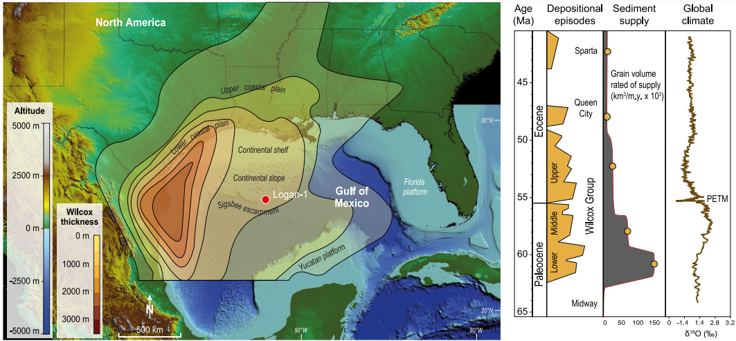
Vimpere et al. obtained a 543 m thick section from the Logan-1 ultra-deep-water wildcat well, which was sunk in 2011 on Walker Ridge Block, which includes the outer part of the Wilcox Group, about 400 km to the southeast of New Orleans. This well excavated a core beneath 2364 m of water, to a depth of 8351 m beneath sea level. One hundred and seventy eight samples were taken from this section, at three meter intervals, then subjected to bulk and clay X-ray diffraction, Rock-Eval pyrolysis, granulometric, organic carbon isotope, palynological, and calcareous nannofossil analyses.

Topobathymetric elevation model of North America showing the Logan-1 well location (drilled in 2011 on Walker Ridge Block 969, ID WR 969 ST0 #1) and present main geographic features. Depositional context during the Paleocene-Eocene transition is represented by Wilcox Group thickness and key tectono-stratigraphic events in the Gulf of Mexico sediment routing system. PETM; Palaeocene–Eocene Thermal Maximum. Vimpere et al. (2023).

Examination of palynomorphs and calcareous nanofossils identified the Palaeocene–Eocene Thermal Maximum interval as being present between  8181 and 8001 m within the Logan-1 core, and the  Palaeocene-Eocene boundary as lying between the NP9 and NP10-0 horizons of the calcareous nannofossil assemblage. The carbon-isotope excursion can also be identified within the core, at 8196–8001 m, with an onset 15 m below the Palaeocene-Eocene boundary, and no hiatus in sediment deposition. This pattern has been observed at a variety of locations, and suggests a link between the onset of the Palaeocene–Eocene Thermal Maximum and late Palaeocene volcanism on the e North Atlantic volcanic province, the Caribbean, and mid-ocean ridge areas. The main body interval of the carbon-isotope excursion is found between  8196 and 8108 m, and the recovery phase between 8108 and 8101 m. This gives a Palaeocene–Eocene Thermal Maximum deposit with a thickness of 195 m, making it the thickest Palaeocene–Eocene Thermal Maximum deposit yet discovered. This contrasts with other well cores sunk in the Gulf of Mexico, in which the Palaeocene–Eocene Thermal Maximum sequence has been truncated. A marked increase in the abundance of Dinoflagellate cyst Apectodinium spp. was observed at 8169 m, while glauconite concentrations increased at 8172 m. Both of these are thought to represent sediments having become condensed, and a shift in the shoreline to landward, caused by deepening sealevels associated with the global temperature rise. 

Carbon isotope, glauconite concentration, chronostratigraphic, and lithostratigraphic data and correlations with Gulf of Mexico standard stratigraphy for the section studied in the Logan-1 well (drilled in 2011 on Walker Ridge Block 969, ID WR 969 ST0 #1). δ13Corg measurements and three-point averages are illustrated by the circles and the curve, respectively. GR, gamma ray; Sh, shale; Slt, silt; Snd, sand; YS, Yoakum Shale; CIE, carbon isotope excursion; PETM, Palaeocene–Eocene Thermal Maximum. Nannofossils: Bomolithus aquilus, Discoaster araneus, Discoaster mahmoudii, Discoaster diastypus, Fasciculithus tympaniformis, Rhomboaster cuspis, Rhomboaster bitrifida, Tribrachiatus bramlettei, Discoaster mahmoudii, Coccolithus bownii, Bomolithus supremus, Tribrachiatus bramlettei, Thomsonipollis, Fasciculithus richardii, Caycedoae megastypus, Discoaster multiradiatus, Fasciculithus lillianiae, Fasciculithus richardii, Discoaster acutus. Vimpere et al. (2023).

These results suggest that, in this part of the Gulf of Mexico, sedimentation rates were significantly increased during the Palaeocene–Eocene Thermal Maximum. If the Palaeocene–Eocene Thermal Maximum is assumed to have lasted 170 000 years, then this part of the Gulf of Mexico apparently had an average sedimentation rate of 1.15 m per 1000 years during this interval. The main body of the event comprises 88 m of sediment, thought to have been laid down in 80 000 years, giving a sedimentation rate of 1.1 m per 1000 years, while the recovery period is represented by 107 m of sediment laid down in 118 000 years, giving a sedimentation rate of 1.18 m per 1000 years, although distinguishing the main body from the recovery period is difficult, leading to a substantial margin of error in these calculations.

The Yoakum Shale is considered to represent a maximum flooding surface, created when the Palaeocene–Eocene Thermal Maximum caused the shoreline to retreat by 150 m. In the submarine deposits of the Gulf Coastal Plain this corresponds with a drop in the amount of terrestrial sedimentary material arriving, and the formation of an number of submarine canyons, most notably the Yoakum Canyon off the coast of Texas. These canyons tended to funnel sediments down into the ocean basin, bypassing much of the continental shelf, which became starved of sediment. The sediments of the shelf show a higher proportion of marine palynomorphs (which settle out of the water column) than terrestrial palynomorphs (which are carried out to sea with sediment) during this interval, and are also enriched in glauconite (which only forms in marine settings) relative to the rest of the sediment column. 

Palaeographic map of the northern Gulf of Mexico showing evolution of the depositional systems throughout the Paleocene–Eocene Thermal Maximum. Vimpere et al. (2023).

It could be presumed that the heating and increase in sealevel associated with the Palaeocene–Eocene Thermal Maximum led to the transgression onto the shores of the Gulf of Mexicoby itself, however Vimpere et al.'s findings suggest that this was at least in part due to subsidance of the coastal margins associated with the formation of the submarine canyons, although there is not sufficient data to make an absolute assessment of the influence of the two phenomena.

During the Early Eocene, uplift associated with the second pulse of the Laramide Orgeny forced the waterways carrying sediments into the Gulf of Mexico to shift towards the southwest. This is recorded in the Upper Wilcox deposits, where several major fluvio-deltaic systems are rejuvinated. This in turn led to stabilization of the system, with less wandering by channels, enabling sediments to build up and prograde out over the shelf margin. This prograding of the delta sediments is matched by the development of a sandy apron in the deep sea basin, probably formed as the prograding sediments reached the head of the submarine canyons.

Schematic representation of the evolution of the sediment-routing system of North America throughout the Palaeocene–Eocene Thermal Maximum. Increased channel mobility and floodplain reworking led to preferential transport of clays into the basin (i.e., Yoakum Shale) through bypass of the shelf within submarine canyons. Upper Wilcox corresponds to resuming of preferential transport of coarse material into basin-floor aprons due to progradation of deltaic sands onto the shelf and the mud removal by waves. Vimpere et al. (2023).

Within the Logan-1 drill core the Yoakum Shale is overlain by a series of sandy beds which reach from the top of the Yoakum at 8120 m up to 8007 m. This is thought to be linked to the development of a more extreme climate, which switched periodically between intense drought phases and intervals of heavy precipitation. This created periodic heavy flows within the river basins, washing out to see accumulated sands, derived from rocks uplifted by the Laramide Orogeny. The inshore environment is also likely to have suffered an increase in storm and wave action, washing sediments from the delta lobes down into the deep ocean basin. 

Vimpere et al. were able to use a multi-disciplinary approach to locate the Palaeocene-Eocene boundary, Palaeocene–Eocene Thermal Maximum, and the associated carbon isotope excursion, in sediments about 400 km away from the nearest coast. The carbon isotope excursion here is 195 m thick, and confirmed to represent the Palaeocene–Eocene Thermal Maximum by palynological and microfossil analysis, making it the longest Palaeocene–Eocene Thermal Maximum section known. This implies that sedimentation rates in this part of the basin were extremely high during this interval, which in turn implies a strong sedimentological response to the changing hydrological conditions associated with the Palaeocene–Eocene Thermal Maximum. Since other fan deposits of equivalent age are known at many locations around the world, it is reasonable to assume that this was a global, rather than a regional, response to the Palaeocene–Eocene Thermal Maximum.

See also...

Follow Sciency Thoughts on Facebook.

Follow Sciency Thoughts on Twitter.


Monday, 2 January 2023

Four presumed dead following helicopter crash in the Gulf of Mexico.

The US Coast Guard has called off a search for survivors, following a helicopter crash in the Gulf of Mexico. The helicopter, operated by Rotorcraft Leasing, crashed while taking off from a Walter Oil & Gas owned offshore oil platform, about 16 km to the south of the mouth of the Southwest Pass of the Mississippi River, at about 8.40 am local time on Thursday 29 December 2022. It is reported to have struck the landing pad as it took off, and subsequently to have fallen into the water.

Debris from a helicopter crash on 29 December 2022 next to a Walter Oil & Gas owned offshore oil platform 16 km off the coast of Louisiana. US Coast Guard.

Following an extensive search by helicopter and small boat, which discovered debris from the crash but no signs of the missing pilot or three passengers, the search was called off at 6.15 pm the same day. One of the passengers has been named as David Scarborough (36), from Lizana, Mississippi, who was returning to shore following a two week shift on the oil platform. Scarborough is survived by his wife, Lacy, and a two-year-old son, Sawyer; the couple were expecting a second child in April. The other victims of the crash have not yet been named.

David Scarborough (36), from Lizana, Mississippi, believed to have died in a helicopter crash in the Gulf of Mexico on 29 December 2022. Lacy Scarborough/Sun Herald.

This is the second crash by a Rotocraft Leasing helicopter attended by the US Coast Guard within two weeks; the first incident happened on 15 December when a helicopter with three people on board went down 25 km off the coast of Terrebonne Bay, while attempting to land on an oil platform. On that occasion all three people on board were able to escape into an inflatable raft, and were subsequently airlifted to hospital with back injuries. 

The US Coast Guard also airlifted two workers from offshore oil vessels in the Gulf of Mexico to hospital in December, both also with back injuries, as well as dealing with two separate oil spill incidents.

See also...

Follow Sciency Thoughts on Facebook.

Follow Sciency Thoughts on Twitter.


Tuesday, 7 September 2021

Divers looking for source of oil spill find broken pipelines in the Gulf of Mexico.

Divers searching for the source of an oil slick that appeared on the Gulf of Mexico in the wake of Hurricane Ida have found three broken pipelines on the seabed to the south of the city of New Orleans. The oil was first observed on Wednesday 1 September by an aerial survey caried out by the National Oceanic and Atmospheric Administration, with additional footage being taken from a helicopter chartered by the Associated Press the next day. This prompted a clean-up operation by Talos Energy, who previously leased  Bay Marchand, Block 5, the area where the slick appeared, and Clean Gulf Associatesa nonprofit oil-spill response cooperative hired by Talos to help with the operation. Now divers from Clean Gulf have identified a broken 30 cm diameter pipeline with oil leaking from it, plus two further broken 10 cm pipelines, which are not currently leaking, but which may have contributed to the spill. Talos Energy do not believe that these pipelines were part of their operation, as their records show all seabed pipelines operated by the company were removed when their activities ceased in 2017. If this is correct, then it is unclear who the pipelines belonged to.

 
Satellite image showing an oil slick to the south of Port Fourchon, Louisiana, on 2 September 2021. Maxar Technologies/AP.

Hurricane Ida made landfall in Louisiana on Sunday 29 August 2021, and bringing with it high winds and flooding which led to more than 50 deaths on the eastern United States.  However, the fact that the death toll was not much higher has been hailed as a vindication of the billions of dollars that have been invested in the levee system protecting the city of New Orleans following the catastrophic damage caused by Hurricane Katrina sixteen years ago. The city, which was directly in the path of the storm, suffered wind damage as it was battered by 240 km per hour winds, but only a limited amount of flooding. A plan to evacuate large parts of New Orleans in the event of it being hit by another major hurricane was not put into place because of the rapidity with which the storm formed, developing over the Caribbean Sea only four days before making landfall as the fifth largest storm ever to hit the US coast.

The storm also caused flooding at the Phillips 66 Alliance Refinery, which is beside the Mississippi River to the south of New Orleans, where a sheen has subsequently been observed on the water, implying that some leaking has occurred here to, although the refinery was shut down ahead of the storm, which should have prevented any major incident.

Tropical storms, known as hurricanes in the Atlantic and eastern Pacific, are caused by solar energy heating the air above the oceans, which causes the air to rise leading to an inrush of air. If this happens over a large enough area the inrushing air will start to circulate, as the rotation of the Earth causes the winds closer to the equator to move eastwards compared to those further away (the Coriolis Effect). This leads to tropical storms rotating clockwise in the southern hemisphere and anticlockwise in the northern hemisphere. These storms tend to grow in strength as they move across the ocean and lose it as they pass over land (this is not completely true: many tropical storms peter out without reaching land due to wider atmospheric patterns), since the land tends to absorb solar energy while the sea reflects it.

 
The formation of a tropical cyclone. Natural Disaster Management.

Despite the obvious danger of winds of this speed, which can physically blow people, and other large objects, away as well as damaging buildings and uprooting trees, the real danger from these storms comes from the flooding they bring. Each drop millibar drop in air-pressure leads to an approximate 1 cm rise in sea level, with big tropical storms capable of causing a storm surge of several meters. This is always accompanied by heavy rainfall, since warm air over the ocean leads to evaporation of sea water, which is then carried with the storm. These combined often lead to catastrophic flooding in areas hit by tropical storms.

 
The formation and impact of a storm surge. eSchoolToday.

Many officials in the US, including President Joe Biden, have linked Hurricane Ida directly to global warming, noting that the average storm hitting the US today does seven times as much damage as in the 1970s, that 'hundred year' storms now happen several times a decade, and that states formerly to the north of the hurricane zone are now regularly hit by these storms.

Oil spills are potentially harmful to marine life in a variety of ways. Most obviously it can coat the outside of organisms, causing damage to external structures such as the feathers of Birds and fur of Mammals, as well as smothering many marine invertebrates and plants. It also contains a variety of chemicals which can be directly toxic upset the hormonal balance of many animals. Oil also impedes the feeding of marine organisms, coating both food and feeding organs, but provides an excellent food source for Bacteria, which can lead to Eutrophication events - dramatic increases in Bacteria numbers, which then use all the oxygen in the water, leading other organisms to asphyxiate.

See also...


Follow Sciency Thoughts on Facebook.

Follow Sciency Thoughts on Twitter


Sunday, 22 August 2021

Seventeen confirmed deaths and forty two still missing as flash floods hit Tennessee.

Seventeen people, including several young children, have now been confirmed dead, and another forty two are missing following a series of floods in Humphreys County, Tennessee. Slightly over 43 cm of rain fell in the area around the town of Waverly within 24 hours over the weekend of 21-22 August 2021, exceeding previous rainfall records by more than 8 cm, and causing a series of flood events that swept away many homes and businesses in the area.

 
Flooding around the town of Waverly in Humphreys County, Tennessee. Nashville Fire Department.

The rainfall was caused by a combination of a high pressure system over Texas and a low pressure system over the Mid Atlantic, which pushed waves of humidity laden air to be pushed northwards from the Gulf of Mexico. Low pressure systems are caused by solar energy heating the air above the oceans, which causes the air to rise leading to an inrush of air. Meteorologists have warned that such storms are likely to become much more common with rising global temperatures. Storms of this magnitude were formerly expected roughly once every hundred years in the Tennessee, but this is the second such event this year, following a storm to the south of Nashville in March.

See also...


Follow Sciency Thoughts on Facebook.

Follow Sciency Thoughts on Twitter


Monday, 5 July 2021

Ruptured gas pipeline leads to fountain of fire in the Gulf of Mexico.

A fire broke out on the sea surface in the Gulf of Mexico, after a natural gas pipeline ruptured on Friday 2 July 2021. The pipeline, which connected the KU-C satellite platform on the Ku Maloob Zaap Oil Field, ruptured some time before 5.15 am local time, when the leaking gas ignited, with the fire being brought completely under control by 10.30 am. Although dramatic, nobody was hurt during the incident. It is unclear at this time how the pipeline was damaged, or how the leaking gas was subsequently ignited.

 
A fire on the surface of the Gulf of Mexico on 2 July 2021, caused by a ruptured natural gas pipeline. Manuel López San Martín/Twitter.

The Ku Maloob Zaap oil field is worked by the Mexican state-owned Petróleos Mexicanos (Pemex), in the Bay of Campeche, off the coast of Tabasco State, on the Yucatan Peninsula. The oil field is actually made up of three separate reserves, the Ku reserve, located in Kimmeridgian (Late Jurassic) deposits, the Maloob, which is in Late Cretaceous-Palaeocene strata, and the Eocene Zaap reserve. The field is worked by seventeen drilling platforms connected by 166 km of pipeline. The field has been worked since the early 1980s, with peak production reached in 2009, when the field was producing more than 130 million litres of oil and over three billion litres of natural gas per day, with production having declined steadily since that time.

See also...


Follow Sciency Thoughts on Facebook.

Follow Sciency Thoughts on Twitter.