Showing posts with label Submarine Eruption. Show all posts

Wednesday, 16 October 2019

Eruption on the Metis Shoal underwater volcano.

The Tonga Meteorological Service has issued a warning to aviation following an eruption on Metis Shoal, a submarine volcano between the islands of Koa and Late, on Tuesday 15 October 2019. The volcano began erupting at about 8.30 am local time, producing a column of ash between 4500 and 5000 m high. Volcanic ash is extremely hazardous to aircraft in a number of ways. At its most obvious it is opaque, both visually and to radar. Then it is abrasive, ash particles physically scour aircraft, damaging components and frosting windows. However the ash is most dangerous when it is sucked into jet engines, here the high temperatures can melt the tiny silica particles, forming volcanic glass which then clogs engine. When this happens the only hope the aircraft has is to dive sharply, in the hope that cold air passing through the engine during the descent will cause the glass to shatter, allowing the engine to be restarted. Obviously this is a procedure that pilots try to avoid having to perform.

 An ash column over Metis Shoal, Tonga, on 15 October 2019. Samuela Folaumoetu'i/Real Tonga Airlines.

Metis Shoal is a growing submarine volcano which is (most of the time) slightly below the sea surface. However it has been producing small dome islands following eruptions since at least the 1780s, and while these have, to date, all washed away afterwards, it is likely that one day the volcano will grow into a true volcanic island.

(Top) An exposed island in Metis Shoal in December 2006. Royal New Zealand Air Force/Institute of Geological & Nuclear Sciences/Smithsonian Global Volcanism Program. (Bottom) Waves breaking over the shoal in February 1968, showing the position of an island that appeared in December 1967 then eroded away. Charles Lundquist/Smithsonian Astrophysical Observatory/Smithsonian Global Volcanism Program.

The islands of Tonga lie along the boundary between the Pacific and Australian Tectonic Plates. The Pacific Plate is being subducted beneath the Australian Plate along the Tonga Trench, which forms the boundary between these two plates, with the volcanic islands that make up the archipelago being formed as the subducting plate is melted by the heat of the planet's interior, so that lighter minerals rise up through the overlying plate as liquid magma, which fuels the volcanoes that build the islands.

 Diagram showing subduction along the Tonga Trench, and how this feeds the volcanoes of the Tonga Volcanic Arc. York University.

See also...

https://sciencythoughts.blogspot.com/2019/08/large-pumice-raft-observed-floating.htmlhttps://sciencythoughts.blogspot.com/2019/06/magnitude-59-earthquake-to-east-of-eua.html
https://sciencythoughts.blogspot.com/2018/02/cyclone-gita-reaches-new-zealand.htmlhttps://sciencythoughts.blogspot.com/2017/11/magnitude-68-earthquake-between-tonga.html
https://sciencythoughts.blogspot.com/2015/07/magnitude-62-earthquake-to-northeast-of.htmlhttps://sciencythoughts.blogspot.com/2015/01/eruption-on-hunga-haapai.html


Follow Sciency Thoughts on Facebook.

Tuesday, 13 March 2018

Warning issued to shipping after increase in seismic activity beneath Kick 'em Jenny.

A warning has been issued to shipping after the University of the West Indies Seismic Research Centre in Trinidad detected an an increase in seismic activity beneath Kick 'em Jenny, a submarine volcano about 8 km to the north of Granada this week. Such tremors are often caused by the movement of hot water and volcanic gas beneath a volcano, which could indicate that the volcano is about to erupt. As a precaution a shipping exclusion zone surrounds the Kick 'em Jenny to a distance of 1.5 km; this zone has been increased to 5 km until further notice, due to the heightened risk to shipping during periods of activity.

The approximate location of Kick 'em Jenny. Google Maps.

 Kick 'em Jenny rises 1300 m above the surrounding seafloor, but remains 180 m below the surface. It was first discovered in July 1939, when an eruption broke the surface and threw material several hundred meters into the air, as well as generating a tsunami which was observed as far away as Barbados, though it was too small to cause any damage. However Kick 'em Jenny is labelled on many earlier maritime charts, indicating that people have been aware there was something here for several centuries, even if they did not know the nature of the feature.

The Lesser Antilles are located at the eastern fringe of the Caribbean Tectonic Plate. The Atlantic Plate (strictly speaking, an extension of the South American Plate which runs to the northeast of the Caribbean) is being subducted beneath this, and as it sinks into the Earth, is melted by the heat of the planets interior. Some of the melted material then rises up through the overlying Caribbean Plate as magma, fuelling Kick 'em Jenny and the other volcanoes of the Lesser Antilles Volcanic Arc. The subduction of the Atlantic Plate beneath the Caribbean Plate is not a smooth process, with the two plates constantly sticking together then breaking apart as the tectonic pressure builds up, causing Earthquakes in the process, though since the boundary between the two plates is some way to the east of the islands, Earthquakes in the Lesser Antilles tend to be both deep and offshore, which lessens their destructive potential.

The subduction of the Atlantic Plate beneath the Caribbean Plate fuels the volcanoes of the Lesser Antilles Volcanic Arc. George Pararas-Carayannis.

See also...

http://sciencythoughts.blogspot.co.uk/2018/02/magnitude-52-earthquake-to-north-of.htmlhttp://sciencythoughts.blogspot.co.uk/2017/12/magnitude-52-earthquake-to-northeast-of.html
http://sciencythoughts.blogspot.co.uk/2017/09/magnitude-46-earthquake-to-northeast-of.htmlhttp://sciencythoughts.blogspot.co.uk/2017/05/shipping-warning-issued-after-eruption.html
http://sciencythoughts.blogspot.co.uk/2017/03/magnitude-45-earthquake-to-north-of-st.htmlhttp://sciencythoughts.blogspot.co.uk/2017/02/magnitude-56-earthquake-to-northeast-of.html
Follow Sciency Thoughts on Facebook.

Tuesday, 2 May 2017

Shipping warning issued after eruption on Kick 'em Jenny.

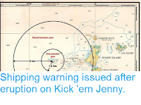
A warning has been issued to shipping after the University of the West Indies Seismic Research Centre in Trinidad detected an eruption on Kick 'em Jenny, a submarine volcano about 8 km to the north of Granada at about 5.45 pm local time on Saturday 29 April 2017. The eruption was reportedly felt on northern Granada, and was followed by a number of further events over the following two days, with over 40 events detected on Monday 1 May.  As a precaution a shipping exclusion zone surrounds the volcano to a distance of 1.5 km; due to the heightened risk to shipping during periods of activity this zone has been increased to 5 km until further notice.

Map showing the exclusion zone around Kick 'em Jenny. Caribbean 360.

Kick 'em Jenny rises 1300 m above the surrounding seafoor, but remains 180 m below the surface. It was first discovered in July 1939, when an eruption broke the surface and threw material several hundred meters into the air, as well as generating a tsunami which was observed as far away as Barbados, though it was too small to cause any damage. However Kick 'em Jenny is labled on many earlier maritime charts, indiating that people have been aware there was something here for several centuries, even if they did not know the nature of the feature.

The Lesser Antilles are located at the eastern fringe of the Caribbean Tectonic Plate. The Atlantic Plate (strictly speaking, an extension of the South American Plate which runs to the northeast of the Caribbean) is being subducted beneath this, and as it sinks into the Earth, is melted by the heat of the planets interior. Some of the melted material then rises up through the overlying Caribbean Plate as magma, fuelling Kick 'em Jenny and the other volcanoes of the Lesser Antilles Volcanic Arc. The subduction of the Atlantic Plate beneath the Caribbean Plate is not a smooth process, with the two plates constantly sticking together then breaking apart as the tectonic pressure builds up, causing Earthquakes in the process, though since the boundary between the two plates is some way to the east of the islands, Earthquakes in the Lesser Antilles tend to be both deep and offshore, which lessens their destructive potential.

 The subduction of the Atlantic Plate beneath the Caribbean Plate fuels the volcanoes of the Lesser Antilles Volcanic Arc. George Pararas-Carayannis.

See also...

http://sciencythoughts.blogspot.co.uk/2017/03/magnitude-45-earthquake-to-north-of-st.htmlhttp://sciencythoughts.blogspot.co.uk/2017/02/magnitude-56-earthquake-to-northeast-of.html
http://sciencythoughts.blogspot.co.uk/2016/12/magnitude-59-earthquake-off-coast-of.htmlhttp://sciencythoughts.blogspot.co.uk/2015/10/magnitude-45-earthquake-in-lesser.html
http://sciencythoughts.blogspot.co.uk/2013/12/five-people-killed-by-landslide-in-st.htmlhttp://sciencythoughts.blogspot.co.uk/2012/03/volcanic-activity-on-soufriere-hills.html
Follow Sciency Thoughts on Facebook. 

Tuesday, 5 May 2015

Eruptive activity on Axial Seamount.

A seismic monitoring system beneath the northeast Pacific operated by the Ocean Observatories Initiative has detected a probable eruption on Axial Seamount, a submarine volcano roughly 480 km off the coast of Oregon. The network has detected around 8000 minor Earthquakes since Friday 1 May, accompanied by a drop in the sea-floor level of about 2.4 meters. Minor tremors around volcanoes are most commonly caused by magma moving through subterranean chambers beneath the vent of the volcano, and are therefore used as advances warning of eruptions. In this instance any eruption would be hard to directly observe due to its remote location, but presents little danger to any human settlement for the same reason.

A vent on Axial Seamount. Schmidt Ocean Institute.

Axial Seamount is a submarine volcano located on the Juan de Fuca Ridge, 480 km west of the Oregon Coast. It has been the subject of extensive study as it is extremely active and is of complex origins: it is on the intersection of the Cobb Hotspot Seamount Chain, and the Juan de Fuca extensional ridge; it is also close to the Blanco Fracture Zone. The seamount rises 700 m above the rest of the Juan de Fuca Ridge and about 1100 m above the surrounding sea floor; it is 1400 m bellow the sea surface. It is a biodiversity hotspot, hosting several 'black-smokers' - underwater hot springs producing super-heated mineral rich water, which support unique ecosystems.

The volcano appears to have a very regular eruptive cycle, enabling scientists to predict eruptions by the rate at which it inflates due to magma movements. It currently appears to be erupting roughly once every four years, having last erupted in 2011, and a 2015 eruption was predicted by Bill Chadwick of Oregon State University and Scott Nooner of the University of North Carolina Wilmington in September 2014.

The approximate location of Axial Seamount. Google Maps.

The Juan de Fuca ridge marks the extensional margin between the Juan de Fuca Plate and the Pacific Plate. The Juan de Fuca Plate is thought to be a remnant of an ancient plate known as the Farallon Plate, a once vast plate now largely subducted beneath the North American Plate. There are three remnants of this plate remaining off the west coast of the US; the Juan de Fuca Plate, the Gorda Plate to the south and the Explorer Plate to the north. The Juan de Fuca Ridge was once part of the longer Farallon Ridge, which ran along the eastern margin of the Farallon Ridge before it was fractured into three parts.

Spreading on the Juan de Fuca Ridge, and its relationship to the volcanoes of the North American west coast. Wikimedia Commons.

The Cobb Seamount Chain runs from the Aleutian Trench off the south coast of Alaska south to Axial Seamount. It is gets its name from the Cobb Seamount, which is 500 km west of the Washington coast, and was named after the research vessel MV John N Cobb; this can cause some confusion as other objects on the seafloor of the NE Pacific are also named after this vessel (Cobb) and are not necessarily related to the seamount chain.

See also...

Axial Seamount is a submarine volcano located on the Juan de Fuca Ridge, 480 km west of the Oregon Coast. It has been the subject of extensive study as it is extremely active and is of complex origins: it is on...


Follow Sciency Thoughts on Facebook.

Thursday, 29 May 2014

Pumice rafts from the July 2012 Havre Seamount eruption.

Pumice forms when hot lava from submarine volcanic eruptions encounters seawater and cools rapidly, simultaneously crystalizing and degassing to form a lightweight volcanic rock with many gas filled vesicles (bubbles) within it, which often floats on the sea surface. Big submarine eruptions can produce large volumes of pumice, forming rafts of pumice that cover hundreds of square kilometres, and drift on the ocean surface for months before dissipating or washing ashore. On 17 July 2012 the Havre Seamount, located at a depth of more than 700 m below sea-level in the Kermadec Arc to the northeast of New Zealand, underwent a dramatic eruption, producing a pumice raft covering over 400 km² in less than 24 hours.

In a paper published in the journal Nature Communications on 22 April 2014, a team of scientists led by Martin Jutzeler of the National Oceanography Centre at the University of Southampton and the Department of Geology at the University of Otago, describe the results of attempts to track this pumice raft using the Moderate-Resolution Imaging Spectroradiometer (MODIS) on the Terra (EOS AM) and Aqua (EOS PM) satellites, as well as to predict the movements of the raft using the NEMO ocean modelling framework, with a view to predicting the movements of future pumice rafts.

Prior to the event of satellite imagery, it was not possible to detect the sources of pumice rafts if they were deeper than about 100 m. The 2012 Havre Seamount eruption was the first deep-water eruption observed by satellite and monitored by an international network of seismometers simultaneously; demonstrating unambiguously that pumice rafts could come from such a source.

An Earthquake swarm with 18 quakes in excess of Magnitude 3.5 was monitored over a 12.5 hour period on 17 July 2012, while images from MODIS showed an atmospheric plume above the seamount as well as a thermal hotspot beneath the sea at its location. The plume is thought to have comprised steam only, and not to have been directly related to the pumice raft. The pumice raft drifted to the northwest in the days following the eruption, drifting far enough from the source that it could be determined no further material was being added; no further plume, raft or discoloured water was seen around Havre for at least six months after the eruption. 

A bathymetric study of the seamount in October 2012 revealed the development of a new 250 m high cone on the southeast rim of the caldera (still more than 700 m below sea-level), as well as a distinct bulge on the crater wall around 800 m below sea-level. Dredges taken at the time found fresh pumice on the seafloor.

Using Modis imigary, Jutzeler et al. were able to follow the progress of the pumice raft from 18 July to 17 November 2012; with additional observations of smaller rafts derived from the original pumice till 22 December. 

Sequential motion of pumice rafts from MODIS images in the first 3 weeks after the eruption. Images taken from Terra and Aqua satellites at 250m resolution; raft colours refer to various dates; scale bar, 40 km. Only a few rafts were hidden by cloud cover. Insert shows regional map; islands are in grey; black lines for 2,000 meters below sea-level contour; dashed rectangle shows location of main map. Jutzeler et al. (2014).


The original raft covered about 400 km², but spread out to cover 120 000-270 000 km² after a month. Assuming that the raft had an average thickness of 50-70 cm, this translates to about 0.03-0.05 km³ of dense rock (translate to better units). Though it is likely that many pumice clasts became waterlogged and sank within 24 hours of the initial eruption, and that the MODIS system was unable to detect all of the floating material, so Jutzeler et al. estimate that Havre probably initially produced about 1 km³of pumice rock, equivalent to 0.15-0.25 km³ of dense rock.

Sequential motion of pumice rafts from MODIS images. Grey polygons show broad areas where pumice clasts are dispersed relative to the Havre volcano. Vectors refer to drift directions to match next raft positions; backward vector on 10 September is due to cloud cover on next date. Main nearby islands of Raoul, Tongatapu and Minerva reef mentioned as landmarks for reference; scale bar 200 km. Jutzeler et al. (2014).

The initial raft remained coherent for the first week then split into a number of smaller segments, primarily elongated ribbons of material, many of which exceeded 100 km in length. Observations of these ribbons by sailing crews showed them to be more extensive than detected by MODIS, for example MODIS images from 5 October 2012 show ribbons extending to within 800 km of  Tongatapu Island from the southwest, while boat crews recorded encountering the rafts 230 km southwest of the island.

The break-up of the main raft and formation of ribbons of pumice appeared to be driven by sorting of the material by wind and ocean currents. The wind seldom blows in the same direction as ocean currents, so the proportion of a pumice clast above the water, which is exposed to the wind, will be pushed in a different direction to the proportion below the water, which is exposed to ocean currents. Therefore the resultant net direction of the clast’s movement will be driven by a ratio between the surface area of the clast exposed to the wind and the surface area of the clast exposed to ocean currents. Since this ratio is determined by a clast’s size and shape, over time the action of the wind and ocean currents will separate the pumice into discreet units with similar sizes and shapes. In practice the ribbons moved many times faster than the thicker mats, suggesting that the movement of these was largely determined by the wind. Examination of material in ribbons by boat crews revealed that each was indeed made up largely of clasts of similar size.

MODIS satellite images of the pumice raft from the July 2012 Havre submarine eruption. (a) Syn-eruptive plume (white trail) and pumice raft (yellow) above the submarine vent (arrow) with initial northwest drift (19 July; 01:26 UTC). Note the discoloured water adjacent to the raft (light blue). (b) The pumice raft is very elongated and swirls (25 July; 00:50 UTC). Note the persistent discoloured water adjacent to the raft. (c) Effect of wind shear and/or oceanic surface currents on elongated bands of pumice rafts. The pumice rafts are dispersed into smaller ribbons of pumice clasts; arrows show a deduced southeast-trending wind direction (8 August; 22:08 UTC). (d) Pumice raft is widely dispersed and forms very complex dispersal patterns (19 August; 00:44 UTC). Satellite resolution is 250 m; true North is up the page. The original images from MODIS46 were filtered (vibrance and saturation) to increase contrasts; scale bars are 20 km. Jutzeler et al. (2014).

While not as obviously hazardous as pyroclastic flows or lava bombs, pumice rafts can still prove disruptive to human activity and at times even dangerous. Rafts can disrupt fisheries (and make fishing impossible) for long periods of time, as well as blocking harbours or other waterways, and physically abrading the sides of ships or other objects in the water. More seriously pumice entering the water intake system of a ship is likely to block up this system causing engines to fail. Since almost all modern ships are reliant on water intake systems for engine cooling, and since failure of engines typically results in failure of electrical systems on a ship, leaving it without navigation or communication systems, ships are forced to take lengthy detours to avoid pumice rafts, often leading to significant increases in both the duration and expense of maritime journeys.

In order to better predict the movements of future pumice rafts, Jutzeler et al. attempted to build a software model of the movements of the Havre pumice using data on past currents and winds from the NEMO ocean modelling framework. This contained data for the affected area from 1988-2010, requiring pumice movements to be predicted from composite wind and current trajectories (something that would be necessary when trying to predict the future movements of a pumice raft). The model proved to be largely accurate, although it failed to predict the extent to which the pumice drifted to the north and northeast during the first three months after the event. The model extended to 180 days after the eruptive event, further than the MODIS system was able to monitor the dissipating pumice rafts, though this appeared to be fairly accurate; it was possible to monitor the movement of the rafts from the surface to some extent after the MODIS system had lost track of them, particularly by records of strandings of pumice on beaches.

Comparison between MODIS and NEMO particle trajectory data. The comparison shows good fit between observations and simulations. The dispersal of pumice clasts using ARIANE with output from the NEMO 1/12 hindcast simulation shows the location of 232,400 particles after (a) 30, (b) 60, (c) 90, (d) 120 and (e) 180 days, respectively, in the five panels. Pink dots are past tracks, black dots are last day of simulated drifting. MODIS imagery shows past tracks (light blue polygons with dark blue contour) and last day (medium blue polygons) of data. The Havre caldera volcano (yellow star) and Tongatapu island are shown. For each panel, rose diagrams correspond to the dispersal simulated with NEMO. The radial axis indicates the number of particles (out of 23 X 2,400) per 18˚ sector. Jutzeler et al. (2014).

Pumice strandings associated with the July 2012 Havre Seamount eruption were recorded in the Bay of Plenty on North Island, New Zealand, in April 2013 (roughly 260 days after the eruption), the Great Barrier Reef in September-October 2013 (roughly 440 days after the eruption) and subsequently on the beaches of New South Wales.

See also…


When volcanic activity began off the south coast of El Hierro, in the Canary Islands, in October 2010, it led to the production of large plumes of pumice-like rocks that floated on the surface of the ocean, producing a distinctive volcanic 'stain'. Pumice is a volcanic rock which contains large vesicles (sealed, gas filled cavities) which cause it to float on the water, which is formed by superheated magma coming into contact with seawater and is a...


Pumice is a volcanic rock, produced by the rapid cooling of gas rich lava from submarine eruptions, or high-pressure eruptions on land. The rapid cooling traps bubbles of gas within the rock, creating a...


When the HMNZS Canterbury encountered a floating raft of pumice stone last week, scientists at New Zealand’s GNS Science assumed it had come from the Monowai Seamount, a submarine volcano in the...


Follow Sciency Thoughts on Facebook.

Monday, 14 October 2013

Submarine eruption to the northwest of Jebel Zubair.

The Zubair Archipelago are a group of volcanic islands off the southwest coast of Yemen; they are essentially a shield volcano on the Red Sea Rift with a number of vents. The had been quiet from about 1848 until December 2011, when a series of eruptions from a vent to the northeast of Jebel Zubair island (the largest island of the group) began, persisting through January 2012. A new eruption began on 28 September 2013 a new series of eruptions began, this time to the northwest of Jebel Zubair and the southeast of the 2011/12 eruptions. This eruption has the form of a steam plume and increase in atmospheric sulphur dioxide (SO₂), detected by NASA's Terra Satellite, and further observed over the following days. To date no ash or pumice produced by this eruption has been detected, suggesting that it is not (yet) a major event.

The approximate location of the Jebel Zubair eruption. Google Maps.

The Red Sea Rift is a spreading boundary between two tectonic plates, the African Plate and the Arabian, where new oceanic crust is being formed. Arabia was formerly part of the African Plate, but split away about 30 million years ago. The Great Rift Valley of Africa is a continuation of this rift, that is slowly splitting Africa in two from the north to the south.


Follow Sciency Thoughts on Facebook.

Friday, 2 August 2013

The floating stones of El Hierro.

When volcanic activity began off the south coast of El Hierro, in the Canary Islands, in October 2010, it led to the production of large plumes of pumice-like rocks that floated on the surface of the ocean, producing a distinctive volcanic 'stain'. Pumice is a volcanic rock which contains large vesicles (sealed, gas filled cavities) which cause it to float on the water, which is formed by superheated magma coming into contact with seawater and is a common product of submarine eruptions. However closer inspection of the floating stones of El Hierro resembled pumice only superficially, being comprised largely of wollastonite (a metamorphicly altered form of limestone) and having quartz sand inclusions. These strange rocks became known as restingolites, after the village of La Restinga, on the southern tip of El Hierro.

In a paper published in the journal Solid Earth on 13 March 2012, a team of scientists led by Valentin Troll of the Department of Earth Sciences at Uppsala University and the Istituto Nazionale di Geofisica e Vulcanologia in Rome develop a theory on the origin of these restingolites.

Restingolites from El Hierro. Troll et al. (2012).

Troll et al. conclude that the floating stones of El Hierro derive not from hot magma, but rather from the metamorphic alteration of sediments on the seafloor as magma welled up around them, heating the sediments and causing a mixture of melting and degassing that produced a pumice-like sedimentary rock, often with a thin crust of true volcanic material, that they refer to as xenopumice, as they are pumice-like in appearance, but xenolithic in origin (i.e. they derive from material alien to the actual magma-flow). They note that similar clasts have been found within volcanically derived sediments at other sites in the Canaries, which suggests that the formation of the El Hierro xenopumice stones was not a unique event, and may be common to the early stages of many submarine eruptions.

Sketch showing the internal structure of El Hierro Island. Ascending magma is interacting with the pre-volcanic sedimentary rocks, and Troll et al. suggest that the early floating stones found at El Hierro are the products of magma-sediment interaction beneath the volcano. Pre-island sedimentary material was carried to the ocean floor during magma ascent and eruption and melted and vesiculated while immersed in magma to develop a pumice-like texture (xenopumice). Once erupted onto the ocean floor, these xenopumices separated from the host lava and floated on the sea surface due to their high vesicularity (i.e. their low density). Troll et al. (2012).


Follow Sciency Thoughts on Facebook.

Monday, 20 August 2012

The biology of pumice rafts.

Pumice is a volcanic rock, produced by the rapid cooling of gas rich lava from submarine eruptions, or high-pressure eruptions on land. The rapid cooling traps bubbles of gas within the rock, creating a very light material that will often float on water. Submarine volcanic eruptions can produce vast mats of pumice, which cover hundreds of square kilometers and persist for years, traveling vast distances across the oceans. While this is unusual on a human timescale, it is very common geologically, with 20 major events known in the last 200 years (not including the Kermadec Islands event of July/August 2012), suggesting that pumice rafts could provide a major dispersal mechanism for marine organisms. 

In a paper published in the journal PLoS One on 18 July 2012, a team of scientists led by Scott Bryan of the School of Geography, Geology and Environment at Kingston University and the School of Earth, Environmental and Biological Sciences at the Queensland University of Technology report the results of a study of a pumice raft produced by Home Reef Volcano in Tonga in 2006. 

Home Reef is a submarine volcano midway between Metis Shoal and Late Island in Tonga. It currently has a summit 10 m bellow sea-level, but sometimes rises above the waves forming ephemeral islands. In August 2006 the volcano an eruption produced a pumice raft covering over 440 km², which then drifted through the islands of Tonga and Fiji before reaching the Australian coast in March 2007, by which time it had spread out to cover about 1600 km²; roughly ⅔ of the original material is thought to have reached Australian waters.

Map showing the progress of the Home Reef pumice raft. Bryan et al. (2012).

The pumice proved to be a very good transport system for marine organisms with a short larval stage and an attached adult phase. Unlike other floating material, such as rafts of algae (Seaweed) or wood, it started out with nothing living on it, thus everything present had to reach it, but it was long-lived on the surface, due to the nature of its buoyancy, and its lack of nutritious value (biological rafts are typically broken up in the end by feeding).

The pumice was host to a wider range of organisms than found by previous studies, which had concentrated on beech-collected pumice, where typically only the remains of mineralized shells of attached organisms were found; non-mineralized organisms on stranded pumice quickly die and decay, and non-attached organisms (e.g. crabs) simply walk away. The amount of organisms growing on the pumice grew steadily as time progressed, with some organisms living long enough to spawn and produce a second generation.

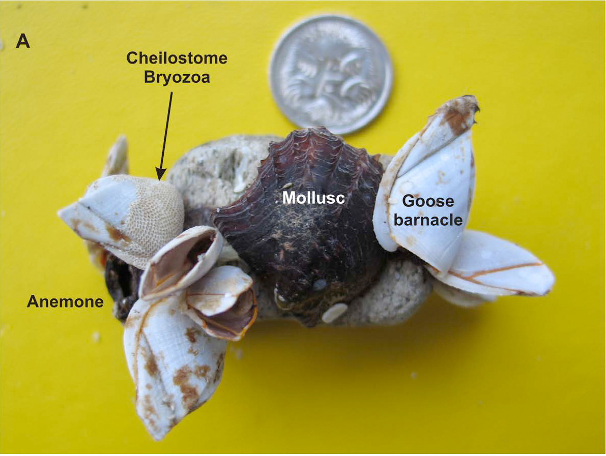
Piece of pumice collected at Marion Reef (roughly 450 km off the Queensland coast) on 30 April 2007. Based upon their size, the Goose Barnacles (Lepas anserifera; largest specimen 23 mm length) have been attached for at least 60 days and the Mollusc over 200. Coin is 2 cm in diameter. Bryan et al. (2012).

Two pieces of pumice bound together by Cyanobacteria (photosynthetic filament-forming Bacteria, principally Rivularia sp.) and Macroalgae (Seaweed, Caulerpa sp.) collected from Broadbeach in southeastern Queensland on 27 December 2007. Also present are two Cauliflower Corals (Pocillopora sp.), a Colonial Scyphozoan (Order Coronatae, the benthic larval stage of a Crown Jellyfish), Goose Barnacles (Lepas anserifera) and a Pearl Oyster (Pinctada sp.) Bryan et al. (2012).

Three pieces of pumice collected from Broadbeach in southeastern Queensland on 27 December 2007. Each has a Sea Anemone (Calliactus sp.) forming a keel, with Cheilostome Bryozoa (Jellyella sp.) along the waterline and Cyanobacteria (Rivularia spp.) occupying allof the dorsal surface. Left hand pumice stone is 5 cm in length. Bryan et al. (2012).

Piece of pumice collected at Lamberts Beach, Mackay, with dorsal surfaces almost exclusively occupied by Cyanobacteria (Rivularia sp.), and the ventral surface entirely covered by cheilostome Bryozoa (Jellyella sp.) colonies. Piece is 1.7 cm long. Bryan et al. (2012).


Follow Sciency Thoughts on Facebook.

Tuesday, 14 August 2012

Pumice raft linked to Havre Seamount, not Monowai.

When the HMNZS Canterbury encountered a floating raft of pumice stone last week, scientists at New Zealand’s GNS Science assumed it had come from the Monowai Seamount, a submarine volcano in the Kermadec Islands noted for regular eruptions, which has been active this month. However a report of the raft made on 1 August by an airline pilot has subsequently emerged, a report made before the start of the Monowai eruption. Scientists have now examined satellite images of the Kermadec region, and concluded the rafts started to form on or around 19 July, and that they appear to be connected to a number of Earthquakes detected in the region on 17-18 July, and a thermal anomaly on Havre Seamount on 18 July.
Thermal image of the Kermadec region taken on 18 July 2012 by the MODIS Satellite System. Université Libre de Bruxelles.

Havre is much less well known than Monowai; its summit is 1100 m bellow the sea surface, and it has never been known to erupt before, and had not previously been identified as an active volcano. Like Monowai it is located on the Kermadec Ridge, a chain of (mostly) submarine volcanoes fed by the subduction of the Pacific Plate beneath the Australian Plate, which produces liquid magma as the underlying Pacific Plate is melted by friction and the heat of the Earth's interior.

Map showing the location of Havre Seamount. Google Maps.

Seamount is a term applied to any mountain entirely submerged beneath the ocean (mountains that stick out of the ocean are islands). Most of these are presumed to be extinct volcanoes, with a minority known to be still active (non-volcanic fold mountains are thought to be a feature of continental plates, not found in the oceans. Seamounts often form unique ecosystems, where the seabed is thousands of meters higher than the surrounding abyssal plains and thus forms a completely different environment. Seamounts that rise close to the ocean surface are often host to coral reefs. Unfortunately the rich ecosystems of seamounts has made them a prime target for the fishing industry, and many have been damaged by unregulated trawling.

Pumice rafts are the equivalent of volcanic plumes produced by submarine volcanoes. When a volcano under the sea produces an ejection rich in gas and liquid lava, the lava is cooled rapidly by contact with the cold ocean water, forming pumice, a light volcanic rock containing bubbles of trapped gas. This typically lighter than water, and major eruptions can produce large rafts of pumice, covering thousands of square kilometers. This in itself forms a unique ecosystem, carrying large colonies of algae and encrusting organisms.


Follow Sciency Thoughts on Facebook.