Showing posts with label South Carolina. Show all posts

Friday, 3 January 2025

Using strontium isotope ratios to try to determine the origin of victims of the transAtlantic slave trade.

Between the fifteenth to nineteenth centuries, at least 12.5 million people were abducted from sub-Saharan Africa and taken as slaves to the Americas, and to a lesser extent Europe, the largest forced migration in Human history. This has had a profound impact on the demographics, economics, and politics of both Africa and the Americas, and while is some ways the process was well-documented (we have, for example, documented records of the voyages of at least 30 079 vessels which were involved in the slave trade, including records of ports they visited and the number of captives they transported), we know very little about the identities of the individuals involved and their actual points of origin.

Recent studies have used genetic information from archaeological remains from the Caribbean, Brazil, North America, St Helena, and South Africa, have had some success in determining the populations from which individuals descended, this cannot tell us where they a person was born or brought up.

Strontium isotopes (specifically the ratio between the isotopes strontium⁸⁷ and strontium⁸⁶) in water are largely determined by bedrock, as well as rainfall and geomorphology, and is taken up and incorporated into biomineralized tissues, such as tooth and bone. Importantly, these ratios remain stable over archaeological timescales, enabling archaeologists to use them to determine the origin of Human and Animal remains, as long as a geological reference map, with the isotope ratios present in appropriate locations, is available. 

In sub-Saharan Africa, strontium isotope ratios have been used to trace the migration routes of large Mammals, and to determine the origin of ivory seized from smugglers, as well as to analyse landscape use by early Hominins, but has been under-used in other spheres, such as historical archaeology, largely because data on strontium isotope ratios are not available for large areas of the continent, and in particular much of West and West-Central Africa, the areas from which the overwhelming majority of slaves were taken to the New World. This is in part due to the high cost associated with carrying out strontium isotope testing over large areas, with the added complication that some parts of the continent are plagued by ongoing conflicts and political instability, making the necessary fieldwork difficult and dangerous.

In a paper published in the journal Nature Communications on 30 December 2024, a team of scientists led by Xueye Wang of the Center for Archaeological Science at Sichuan University and the Anthropology Department at the University of California Santa Cruz, present strontium isotope ratios from 778 new environmental studies from 24 African countries, mostly in West and West-Central Africa, which they combine with 1488 previously published strontium isotope ratios from other studies, to build a more detailed map of strontium isotope ratios across sub-Saharan Africa. These are then compared to ratios obtained from Human remains at two cemeteries in the Americas associated with African slaves, the Anson Street African Burial Ground in Charleston, South Carolina, and the Pretos Novos Cemetery in Rio de Janeiro, Brazil.

Strontium⁸⁷/strontium⁸⁶ ratios in Africa range from 0.70381 to 0.87810, a far higher range than is known from any other continent studied. Some areas have a high proportion of radiogenic strontium⁸⁷, notably those areas with an underlying Archaean bedrock, such as Angola, Zimbabwe, Zambia, western Tanzania, northern South Africa, Côte d'Ivoire, Liberia, Sierra Leone, and southwestern Mali. Other areas have a very low level of strontium⁸⁷, particularly areas of East Africa covered by Mesozoic-Cainozoic volcanic rocks, and areas of South Africa covered by flood basalts, as these tend to generate soils with a high cation exchange capacity and clay content. Strontium ratios are also affected by precipitation levels and elevation, both of which impact the weathering rate of silicate rocks.
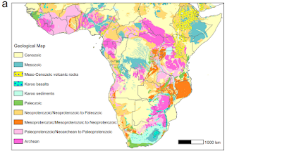
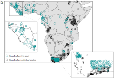
Geological map and sampling locations. (a) Simplified geological map. (b) Map showing the environmental sampling locations from this study and previously published work. The sampling locations focused on filling gaps in West Africa, West-Central Africa, and parts of South Africa, covering all major geological units across the African continent south of the Sahara. Wang et al. (2024).

Strontium isotope ratios were analysed for five individuals from the Anson Street African Burial Ground for which genetic analysis had been used to determine a population-of-origin, and five individuals from the Pretos Novos Cemetery, for which this data was not available, but oxygen isotope ratios, which can be used to determine diet, were.

Two of the Anson Street African Burial Ground individuals had previously been determined to be of West-Central African origin, both of which produced strontium isotope ratios consistent with an origin in eastern-central Angola. The remaining three individuals were all determined to be from West Africa by genetic analysis. The first of these produced a strontium isotope ratio which indicates that they could have originated from a wide area, including large regions of Liberia, Côte d’Ivoire, Guinea, Sierra Leone, and Mali. The remaining two individuals showed much higher levels of radiogenic strontium, consistent with having come from either a 100 km stretch of the coast of southern Côte d’Ivoire and Ghana, or from the eastern part of Guinea.

Four of the five individuals from the Pretos Novos Cemetery produced strontium isotope ratios consistent with having come from different regions of Angola or South-East Africa, while the fifth produced a result consistent with having come from parts of Guinea, Nigeria, Cameroon, or South Africa. 

Oxygen isotope ratios suggest that this individual grew up in a region where the main crops were C₄ Plants. This would exclude the 'Rice Coast' of West Africa, which runs from Guinea Bissau through Guinea into western Côte d’Ivoire, or the vegecultural zone of southern West Africa, where the predominant crops are Manioc, Yams, and other C₃ root vegetables, but would include parts of central Nigeria where the main crops are Sorghum and Millet, and parts of northern Cameroon where different areas would have grown Sorghum and Millet or Maize (itself introduced from the Americas by European traders). Potentially, a South African could have also had a diet dominated by C₄ Plants, which are easily grown in many places there, but Wang et al. consider this less likely, given the much larger number of slaves taken from West Africa to Brazil.

The four other individuals from Pretos Novos Cemetery are hypothesized to have come from different parts of Angola based upon strontium isotope ratios. This was supported by the oxygen isotope analysis, which suggests they did not share common dietary habits in early life. This is consistent with the known agricultural practices in Angola at the time, with different regions emphasizing the cultivation of manioc and other root crops, or maize and millet.

Wang et al. are confident that improved groundwater sampling from a wider area of Africa would have the potential to greatly improve our ability to determine the origin of African remains from the New World. With the limited sampling available, they were able to provide approximate locations of origin for ten individuals from two well-studied burial grounds, one in the United States and the other in Brazil, and while their answers cannot be taken as 100% reliable at this stage, none of them contradict data from previous studies, nor do they suggest improbable points of origin for the individuals examined.

There are still some notable gaps in the strontium ratio maps used by Wang et al. most notably Namibia and the Sahel Region. Wang et al. identify these regions as being sparsely populated, and therefore unlikely to have been heavily targeted by slavers. This is probably true for Namibia, where the most habitable areas are separated from the coat be large areas of desert, but certainly isn't true for the Sahel Region, which was home to powerful states such as the Mali Empire, and where travellers such as Mungo Park recorded extensive activity by slavers. Sampling is also limited for Mozambique, from where historical records show that at least half a million people were taken as slaves in the first half of the nineteenth century. The method is further limited in that it can only trace the origins of people born and raised in Africa, anyone raised in the Americas will have a strontium isotope signal from there, no matter where their parents came from.

Wang et al. also note that an improved isotope map for Africa, particularly if it includes other elements, such as oxygen, hydrogen, sulphur, and carbon, has the potential to improve not just our ability to identify the origins of Human remains from archaeological contexts, but also items such as smuggled wildlife and timber. It also has the ability to improve our understanding of wildlife migrations, or historic dispersals, including those of species extinct today. Moreover, it also has the ability to help identify the thousands of African migrants who perish in the Mediterranean Sea during their passage to southern Europe, something which has been described as potentially the greatest humanitarian disaster in Europe since the Second World War.

See also...

Thursday, 16 April 2020

Large numbers of Cannonball Jellyfish stranding on Hilton Head Island, South Carolina.

Residents of Hilton Head Island in South Carolina have reported seeing large numbers of Cannonball Jellyfish, Stomolophus meleagris, stranding on beaches on the northern part of the island this week. The Jellyfish started to appear on Friday 10 April 2020, with thousands being seen in some areas. Whilst such large-scale strandings are potentially alarming, they are quite common in the area at this time of year, as packages of warm, nutrient-poor, water from the Gulf Stream begin to come closer to the shore, encountering the cooler, nutrient-rich water of the inshore environment, causing the Jellyfish to undergo population explosions called blooms. Large numbers of Jellyfish in the water can very quickly turn into large numbers of Jellyfish on a beach, as these animals are poor swimmers, and tend to drift where currents and sea breezes take them, with the effect that if conditions change and drive them onshore, they have no way to escape.

Cannonball Jellyfish, Stomolophus meleagris, stranded on a beach on Hilton Head Island, South Carolina, on Friday 10 April 2020. Mandy Matney/FitsNews.

Cannonball Jellyfish are common in the Gulf of Mexico and western Atlantic from the southeaster coast of the US south to Brazil, as well as on both the east and west coasts of the Pacific, from California south to Ecuador, and in the South China Sea and Sea of Japan. The Atlantic population is generally brown in colour, while the Pacific population is bluish, but they are considered to be the same species. These Jellyfish reach about 25 cm in diameter, with a distinctive 'cannonball' shaped bell, and a cluster of short oral arms around the mouth. They excrete toxin from the nematocysts (stinging cells) into the water, stunning small prey items and discouraging predators, but are not harmful to Humans, and are widely eaten in parts of Asia, with Jellyfish being exported from the US to Japan, China, and Thailand for consumption.

See also...

https://sciencythoughts.blogspot.com/2020/03/crambione-cf-mastigophora-bloom-of.htmlhttps://sciencythoughts.blogspot.com/2019/12/huge-swarms-of-moon-jellyfish-seen-in.html
https://sciencythoughts.blogspot.com/2019/10/closure-of-nuclear-power-plant-allows.htmlhttps://sciencythoughts.blogspot.com/2019/10/millions-of-moon-jellyfish-seen-in.html
https://sciencythoughts.blogspot.com/2019/01/mercury-and-selenium-levels-in.htmlhttps://sciencythoughts.blogspot.com/2019/01/melicertissa-antrichardsoni-paralovenia.html
Follow Sciency Thoughts on Facebook.

Tuesday, 8 October 2019

South Carolina toddler receives hospital treatment after being bitten by Copperhead.

A toddler in South Carolina has received hospital treatment after being bitten by a Snake on Wednesday 2 October 2019. Atlas Johnson, 2, was bitten on the leg by a Copperhead Snake, Agkistrodon contortrix, while walking on a driveway outside his home in Horry County. He was taken to the Conway Medical Center, where he was treated with antihistamines and monitored for four hours before being discharged. However his condition later deteriorated and he was taken the Medical University of South Carolina, where he was treated with the antivenom CroFab. 

 Bite on the leg of Atlas Johnson, 2, caused by a Copperhead Snake. Casey Watson/WIS TV News.

Copperheads are a type of Pit Viper, Crotalinae, widespread in the eastern and southern United States and parts of Mexico. They are small-to-medium sized Snakes, seldom exceeding a metre in length, and are primarily insectivores. They are ambush predators, favouring woodland environments, where their copper-brown colouration gives them excellent camouflage against leaf litter. Copperheads will generally avoid Humans, but are a common source of bites, as they will generally try to avoid conflict by freezing rather than retreating, with the effect that Humans sometimes do not see them and either step on them or close enough to cause the Snake to lash out. Fortunately the venom of a Copperhead is not very potent, and most bites are 'dry' (i.e. the Snake does not actually inject any venom). For this reason the bite of a Copperhead is usually treated initially with antihistamines rather than antivemon (which can cause allergic reactions worse than the Snake bite), with the later only being used if symptoms persist.

A Copperhead Snake, Agkistrodon contortrix. Edward Wozniak/Centers for Disease Control and Prevention/Wikimedia Commons.

See also...

https://sciencythoughts.blogspot.com/2019/09/erythrolamprus-pseudoreginae-new.htmlhttps://sciencythoughts.blogspot.com/2019/09/indian-schoolgirl-dies-after-being.html
https://sciencythoughts.blogspot.com/2018/11/boa-blanchardensis-dwarf-boid-snake.htmlhttps://sciencythoughts.blogspot.com/2018/08/palaeophis-colossaeus-and-amananulam.html
https://sciencythoughts.blogspot.com/2018/07/xiaophis-myanmarensis-embryonic-to.htmlhttps://sciencythoughts.blogspot.com/2018/04/queensland-man-dies-after-being-bitten.html
Follow Sciency Thoughts on Facebook.

Wednesday, 4 September 2019

Hurricane Dorian confirmed to have killed seven in the Bahamas and one in North Carolina.

Eight people have now been confirmed dead as Hurricane Dorian passed over the Bahamas and up the east coast of the United States. The hurricane swept past several Caribbean island nations between 25 and 30 August 2019, prompting evacuations and curfews, but causing little actual damage. However, over this period it was steadily gaining in strength, so that when it finally made landfall on Elbow Cay in the Bahamas it was a Category Five storm, with sustained winds in excess of 250 km per hour and gusts considerably stronger, and the strongest storm ever recorded to have made landfall from the Atlantic. The storm caused widespread devastation across the Abaco Islands and Grand Bahama, destroying thousands of homes causing widespread flooding and killing at least seven people - though this number is likely to be a severe underestimate due to the damage the storm has caused to the nation's infrastructure. Following this the storm has swept northward up the east coast of the United States, past Florida, Georgia, and South and North Carolina. The storm has brought flooding and high winds to these areas, with storm surges in excess of two metres and one confirmed death in North Carolina, but has been losing strength as it moves north and is now only a Category Two storm.

Flooding and damaged buildings in the Abaco Islands in the wake of Hurricane Dorian. Latrae Rahming.

Tropical storms are caused by the warming effect of the Sun over tropical seas. As the air warms it expands, causing a drop in air pressure, and rises, causing air from outside the area to rush in to replace it. If this happens over a sufficiently wide area then the inrushing winds will be affected by centrifugal forces caused by the Earth's rotation (the Coriolis effect). This means that winds will be deflected clockwise in the northern hemisphere and anti-clockwise in the southern hemisphere, eventually creating a large, rotating Tropical Storm. They have different names in different parts of the world, with those in the northwest Atlantic being referred to as hurricanes.

 The path and strength of Hurricane Dorian. Thick line indicates the past path of the storm (till 3.00 pm GMT on Tuesday 4 September 2019), while the thin line indicates the predicted future path of the storm, and the dotted circles the margin of error at nine, twenty one, thirty three, forty five, sixty nine, ninety three and one hundred and seventeen hours ahead. Colour indicated the severity of the storm. Tropical Storm Risk.

Despite the obvious danger of winds of this speed, which can physically blow people, and other large objects, away as well as damaging buildings and uprooting trees, the real danger from these storms comes from the flooding they bring. Each drop millibar drop in air-pressure leads to an approximate 1 cm rise in sea level, with big tropical storms capable of causing a storm surge of several meters. This is always accompanied by heavy rainfall, since warm air over the ocean leads to evaporation of sea water, which is then carried with the storm. These combined often lead to catastrophic flooding in areas hit by tropical storms. 

See also...

https://sciencythoughts.blogspot.com/2019/07/double-fireball-over-florida-thought-to.htmlhttps://sciencythoughts.blogspot.com/2019/06/american-tourist-killed-in-shark-attack.html
https://sciencythoughts.blogspot.com/2019/06/motorcyclist-killed-by-lightning-in.htmlhttps://sciencythoughts.blogspot.com/2019/06/teenager-injured-by-shark-in-north.html
https://sciencythoughts.blogspot.com/2019/06/sphyrna-mokarran-pregnant-great.htmlhttps://sciencythoughts.blogspot.com/2019/02/meteorites-fall-on-cuban-town-after.html
Follow Sciency Thoughts on Facebook.

Saturday, 7 October 2017

Meteorite hits house in Pawleys Island, South Carolina.

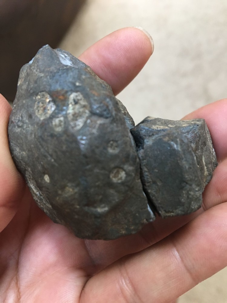
A meteorite apparently hit a house in the town of Pawleys Island in Georgetown County, South Carolina, on 26 September 2017. The object was initially spotted by resident Melanie Casselman, who noticed a strange rock in her yard, but paid it no further attention, assuming it had been thrown there by local kids. However later that day her partner, Dennis Suszko, found a second piece of similar rock, which his son, Christopher, was able to fit to the original rock, as well as minor damage to their roof, consistent with having been hit by a falling rock. Noticing that the rocks did not resemble any others to be seen locally, Casselman and Suszko searched online and found images of similar looking meteorites. This prompted them to contact astrophysicist Sean Brittain of the Department of Physics & Astronomy at Clemson University, who confirmed the object was in fact a meteorite.

The September 2017 Pawleys Island Meteorite. Clemson University.

Brittain was able to confirm the iron-rich rock was a meteorite by the presence of flowlines on its surface, indicating that that surface had been molten as it fell through the atmosphere. Meteorites that fall to the ground are typically chunks of larger rocks that have exploded in the upper atmosphere due to heat from friction caused by the velocity from their orbit which far exceeds that caused by gravitational falling. Meteorites that fall to Earth are a byproduct of such explosions, fragments of rock from the interior of the asteroid that fall to Earth under gravity, which is not enough to heat them. Such meteorites typically have fire-blackened, melted, exteriors, a result of the initial heating and explosion, but this initial heat is usually lost through convection into the interior of the meteorite (which, having come from space, is typically only a few degrees above absolute zero when it begins its journey through the atmosphere), so that the object is cold (usually very cold) when it reaches the ground.

See also...

http://sciencythoughts.blogspot.co.uk/2017/10/meteorite-blamed-for-brush-fire-near.htmlhttp://sciencythoughts.blogspot.co.uk/2017/09/understanding-deposition-of-suevites-in.html
https://blogger.googleusercontent.com/img/b/R29vZ2xl/AVvXsEjflRkrA3MAXtrTaNKrf6Etn1XOUVdblo8wQslKwGpsZnk2gIqa358kzOkvG2xAaDn2USKX-NyG8peHdy5kzg5qoo3oFBT16wZqcc8DTkrlc6oKhIWe7hbOvSBQXumaC6_L_l8hVjbLXNI/s200/Looking+for+pieces+of+the+Piecki+Meteor..pnghttp://sciencythoughts.blogspot.co.uk/2017/01/osterplana-065-unique-meteorite-from.html
http://sciencythoughts.blogspot.co.uk/2016/12/micrometeorites-from-urban-environments.htmlhttp://sciencythoughts.blogspot.co.uk/2016/02/meteorite-unlikely-to-have-killed-man.html
Follow Sciency Thoughts on Facebook.

Friday, 14 April 2017

Fireball over the southern United Sates.

The American Meteor Society has received reports of a bright fireball meteor being seen over parts of the southern United States at about 8.45 am Eastern Daylight Time (slightly after am GMT) on Wednesday 12 April 2017. The majority of the reports came from South Carolina, but sightings were also reported from Georgia, Florida, Virginia, North Carolina, Kentucky and Alabama. A fireball is defined as a meteor (shooting star) brighter than the planet Venus. These are typically caused by pieces of rock burning up in the atmosphere, but can be the result of man-made space-junk burning up on re-entry. The meteor travelled from northeast to southwest, and was last seen over Horry County, South Carolina.

 The 12 April 2017 meteor. Ricky Lucas/WLTX-TV.
 
Objects of this size probably enter the Earth's atmosphere several times a year, though unless they do so over populated areas they are unlikely to be noticed. They are officially described as fireballs if they produce a light brighter than the planet Venus. It is possible that this object will have produced meteorites that reached the surface (an object visible in the sky is a meteor, a rock that falls from the sky and can be physically held and examined is a meteorite).
 
Witness reports can help astronomers to understand these events. If you witnessed this fireball you can report it to the American Meteor Society here.
 
See also...
 
http://sciencythoughts.blogspot.co.uk/2017/03/fireball-meteor-over-british-columbia.htmlhttp://sciencythoughts.blogspot.co.uk/2017/03/fireball-over-northern-texas.html
http://sciencythoughts.blogspot.co.uk/2017/02/looking-for-pieces-of-piecki-meteor.htmlhttp://sciencythoughts.blogspot.co.uk/2017/02/fireball-over-american-mdwest.html
http://sciencythoughts.blogspot.co.uk/2017/02/the-alpha-centaurid-meteors.htmlhttp://sciencythoughts.blogspot.co.uk/2017/01/fireball-over-arkhangelsk-region-of.html
Follow Sciency Thoughts on Facebook.

Saturday, 10 September 2016

Fireball over North Carolina.

The American Meteor Society has received reports of a bright fireball meteor being seen over parts of the southeast of North America slightly after 6.00 pm local time (slightly after 11.00 pm GMT) on Thursday 8 September 2016. The fireball was seen across most of North Carolina, as well as parts of Virginai and South Carolina. The object appeared to be moving from northeast to southwest, and ended its journey somewhere around Enfield, North Carolina (a fireball typically disappears when the meteor causing it explodes in an airburt caused by fricion of its surface with the atmosphere; this typically happens several km in the air, with fragments of the rock faling to the ground as meteorites, though they can drift some distance from where the fireball was last seen before reaching the ground). A fireball is defined as a meteor (shooting star) brighter than the planet Venus. These are typically caused by pieces of rock burning up in the atmosphere, but can be the result of man-made space-junk burning up on re-entry.

 Dashcam image of the 8 September 2016 North Carolina fireball from I-95. Pedro Martinez/American Meteor Society.

Objects of this size probably enter the Earth's atmosphere several times a year, though unless they do so over populated areas they are unlikely to be noticed. They are officially described as fireballs if they produce a light brighter than the planet Venus. It is possible that this object will have produced meteorites that reached the surface (an object visible in the sky is a meteor, a rock that falls from the sky and can be physically held and examined is a meteorite).

Witness reports can help astronomers to understand these events. If you witnessed this fireball you can report it to the American Meteor Society here.

See also...

http://sciencythoughts.blogspot.co.uk/2016/09/fireball-over-oregon.htmlFireball over Oregon.                                   The American Meteor Society has received reports of a bright fireball meteor being seen over much of the northwest of North America at about 11.55 pm local time on Friday 2 September  2016 (about 6.55 am on Saturday 3 September GMT). The fireball was...
http://sciencythoughts.blogspot.co.uk/2016/08/the-perseid-meteors.htmlThe Perseid Meteors.                                     The Perseid Meteor shower lasts from late July to early September each year, and are expected to be at a peak on Thursday 11- Friday12 August 2016. The Moon is expected to be quite bright on that night, however it will be setting at about 1.00 am local...
http://sciencythoughts.blogspot.co.uk/2016/06/fireball-over-arizona.htmlFireball over Arizona.                                   The American Meteor Society has received reports of a bright fireball meteor being seen over much of the southwest United States at about 4.00 am local time on Thursday 2 June 2016 (about 11.00 am GMT). The fireball was seen across Arizona, Utah, New...
Follow Sciency Thoughts on Facebook.