Showing posts with label Biostratigraphy. Show all posts

Sunday, 30 November 2025

Reassessing the contribution of the Deccan Traps volcanism to the End Cretaceous Extinction.

During the Phanerozoic Eon the Earth has suffered a series of major extinction events almost all of which are considered to have been triggered by continental flood basalt emplacement episodes, which released vast amounts of toxic gasses into the atmosphere. The exception to this is the End Cretaceous Extinction, which is largely considered to have been triggered by the impact of an extra-terrestrial object into what is now the Yucatán Peninsula of Mexico. 

While this is a compelling story, it has faced a number of challenges from rival theories, the most notable of which is that there was a significant outpouring of flood basalts at the End of the Cretaceous, leading to the emplacement of the Deccan Traps Igneous Province in India, This, combined with the fact that we have now identified a number of other large impacts in the Phanerozoic rock record, none of which seem to have been associated with extinction events, presents a serious challenge to the Chicxulub Impact Theory. However, studies of the Deccan Traps Igneous Province have suggested that the majority of the basalt-emplacement happened slightly after the extinction event, implying that it cannot have been the cause. 

In a paper published in the journal GSA Bulletin on 5 November 2025, Vivek Kale of the Advanced Center for Water Resources Development and Management, Devdutt Upasani and Madhu Rajput of the Department of Geology at Fergusson College, Gauri Dole of the Department of Environmental Science at Savitribai Phule Pune University, and Shilpa Patil Pillai of the Department of Earth and Climate Science at the Indian Institute of Science Education and Research Pune, present a re-evaluation of the contribution of the Deccan Traps volcanism to the End Cretaceous Extinction, based upon new geochronological studies of the Deccan Traps Igneous Province.

The Deccan Traps Igneous Province covers about 50 000 km² of Western and Central India, and extends westward beneath the Arabian Sea, where it is thought to cover a further area of about 38 000 km². It was produced by shield-volcano-like eruptions, which produced a series of radially overstepping basalt formations. Studies carried out in the 1980s suggested that the onset of the Deccan Traps volcanism coincided with the End Cretaceous Extinction Event, leading the majority of the geological community to conclude that it could not be responsible for the event, and even some suggestions that the volcanism might have been caused in some way by the Chicxulub Impact.

Geographic sectors of the present-day exposures of Deccan volcanic deposits of central and western India (shaded green) on the backdrop of different cratonic blocks (in shades of pink and named in red) of the Indian Peninsular Shield. The named alignments of deep-crustal tectonic zones from this shield, with Precambrian heritage and late Mesozoic to Cenozoic reactivation are depicted with parallel hatching in their respective strike directions.  Locations of sampled offshore basaltic flows with affinities to the Reunion hotspot are shown with green dots in the offshore areas, along with key ocean floor features of the Arabian Sea off the western coast of India. The locations of Late Cretaceous magmatic activity in the Indian Peninsula (early magmatics) are shown as red stars. The maximum projected extent of the Deccan continental flood basalt is shown with a green dotted line. Kale et al. (2025).

However, much of this earlier work was based upon chemostratigraphic correlation between different parts of the Deccan Traps, something which is now considered unreliable as it has been demonstrated that the Traps are in fact made up of a series of subprovinces, the Western, Satpura, Central, Malwa, Mandla, and Saurashtra, each with their own distinct volcanic history. Thus the work carried out in the 1980s appears to have been valid for parts of the Western Subprovince, but not necessarily for any of the other subprovinces.

Kale et al. combined chemostratigraphic methods with palaeomagnetism and studies of key fossils from sedimentary beds interspaced with the volcanic layers, with the aim of understanding the timing and eruptive history of each subprovince of the Deccan Traps. To achieve a high level of confidence, they carried out extensive fieldwork, preparing more than eighty stratigraphic logs. 

Subprovinces of the Deccan Volcanic Province of India (in different shades of green) and the indicative locations of geochronological sections and fossil-bearing intertrappean sediments used in the age assignments of different stratigraphic units in this study. Abbreviation: KPgB, Cretaceous-Paleogene boundary. Kale et al. (2025).

Kale et al. recognised three phases of volcanic activity within the Deccan Traps deposits, phases which were consistently recovered using chemostratigraphic and palaeomagnetic methods. These were the Early Magmatic Phase, the Main Flood Basalt Eruptions, and the Late Volcanic Phase. Deposits associated with the Early Magmatic Phase outcrops in the Saurashtra Subprovince, along the Narmada Son Lineament Zone between the Bastar and Dharwar cratons, and comprises mixed mantle-derived volcanic sediments more than 67.0 million years old. The Late Volcanic Phase comprises intrusive volcanic material inserted into the main deposits after they had been emplaced. These outcrop in a small coastal strip around Mumbai, and have also been found offshore in the Laxmi Basin of the Arabian Sea. This Late Volcanic Phase material is about 63.0 million years old, making them coeval with the separation of the Seychelles from the Western Margin of the Indian Plate. There may also be some material associated with the Late Volcanic Phase at the top of the Amarkantak Group.

The Main phase therefore accounts for about 90% of the material which makes up the Deccan Traps Igneous Province. Furthermore, most of this material appears to have been produced within a period of less than 1 million years within Chron C29r, a period between two reversals of the Earth's magnetic field, which lasted from about 66.43 million years ago to about 65.8 million years ago (therefore spanning the current accepted boundary between the Cretaceous and the Tertiary, at 66.04 million years ago), and the following Chron C29n, which lasted from about 65.8 million years ago to about 64.745 million years ago.

The Western Subprovince hosts the thickest and (probably the) most continuous deposits of the Deccan Traps, as well as the largest single outcrop, at Kalsubai Peak, where a 1642 m continuous stack of basalts is exposed, and continues some way beneath the ground. These deposits are assigned to the Sahyadri Group, which is divided into the Wai, Lonavala and Kalsubai subgroups, with about 3000 m depth of basalt produced within chrons C29r and C29n. These deposits show few fossiliferous sedimentary layers, with scattered 'interflow horizons' (horizons marking time-gaps between episodes of basalt-deposition) of limited lateral extent, suggesting that gaps between eruptive episodes were localised and brief.

Kale et al.'s revised study places the boundary between chrons C29r and C29n at the base of the Mahabaleshwar Formation from the Wai Subgroup of the Sahyadri Group. This is marked by the widespread presence of giant-phenocryst basalt. The Purandargarh Formation, which underlies the Mahabaleshwar Formation, is calculated to date from the earliest part of the Danian Stage of the Palaeocene, i.e. immediately after the Cretaceous-Tertiary boundary. 

The Poladpur Lavas, which underlie the Purandargarh Formation, have been suggested to be of latest Cretaceous origin, on the basis of dates obtained from zircons, but Kale et al. reject this, on the basis that zircons can survive at very high temperatures and are often reworked within volcanic deposits, and also classify the Poladpur Lavas as earliest Danian. Based upon a sediment layer with key Mammalian fossils exposed at Naskal in Telangana State, Kale et al. estimate that the lowest 50 m of the Poladpur Lavas were erupted within 100 000 years of the Cretaceous-Tertiary boundary. The underlying Lonavala and Kalsubai subgroups, therefore, must have erupted entirely within the Latest Cretaceous. 

The Satpura Subprovince forms the second deepest sequence of the Deccan Traps, and has been divided into six formations, with two of these formations containing giant-phenocryst basalts, something which has led to the correlation of the entire subprovince with the Wei Subgroup of the Sahyadri Group. Kale et al. reject this analysis, assigning the entire sequence to the Maastrichtian (Latest Cretaceous) on the basis of fossil inclusions within sedimentary layers.

The Central Subprovince forms the northeastern part of the Deccan Plateau, with a diffuse boundary with the Western subprovince. The lavas of this the Mahur Formation, which form the base of this sequence, also contain a distinctive giant-phenocryst basalt layer, which had led to them being comparied to the Wei Subgroup, but Kale et al. again reject this, assigning this formation to the Maastrichtian on the basis of fossil inclusions. Instead, they place the Cretaceous-Tertiary boundary at the top of the Ajanta Formation, which overlies the Mahur Formation, on the basis of palynological evidence (fossil pollen). This places the final three formations of the Central Subprovince, the Chikhil, the Buldhana, and the Karanja, within the Early Danian.

The Malwa Subprovince sequence has also previously been assigned to the Wei Subgroup, although in this case because it contains a normal-reverse-normal palaeomagnetic sequence, which was thought to mark the Danian chrons C29r and C29n. However, a revised dating sequence suggests that this sequence contains some of the oldest rocks of the Deccan Traps, with only the final, Singachori Formation being Danian in age, while all the lower formations are Maastrichtian, based upon fossil evidence. 

The Mandla Subprovince has proven much harder to establish a chronological sequence for, but appears to contain both some of the oldest and some of the youngest lavas of the Deccan Traps. However, the lowermost Mandla Formation and unclassified underlying beds contain sedimentary layers which produce fossils of Maastrichtian age, while the higher beds of the Multai, Amarwara, Khamla/Khampla, and Kuleru formations contain magnetic reversals and fossils of Palaeocene origin.

Stratigraphic logs of the subprovinces of Deccan Volcanic Province of India depicting dominant morphological types with the approximate position of the 66.05 million-year-old Cretaceous-Palaeogene boundary (red dashed line). In the Sahyadri Group, the cumulative stratigraphic thickness is used, as there is a well-demonstrated southward and southeastward overstepping of the older formations by younger ones. All other logs are plotted for maximum thickness. The available palaeomagnetic orientations (dark, normal; grey, mixed; and white, reverse) are depicted. Abbreviations: BMBY, Bombay Subgroup; LNVL, Lonavala Subgroup; GPB, giant phenocryst basalt. Kale et al. (2025).

The Saurashtra Subprovince is the only part of the Deccan Traps where an iridium layer has been discovered within the Anjur Section, and used as an identifier for the Cretaceous-Tertiary boundary. However, the deposits which host this layer have been shown to belong to Magnetochron C28r, making them too young to be related to the End of the Cretaceous. Other deposits, from layers beneath those exposed at Anjur, have produced Dinosaur bones and nests, as well as other clearly Cretaceous fossils, indicating a Maastrichtian origin. These deposits are also cut through by a series of dykes which have yielded ages of between 66.06 and 62.4 million years. Given the lack of a clear chronological sequence for this group, Kale et al. do not attempt to calculate its full sequence, but for the sake of modelling assume that it contains 5% of the total volume of the Deccan Traps lavas, and that this can be divided equally between the Danian and the Maastrichtian.

Kale et al. also assume that 75% of the Deccan Traps basalts were erupted on land, with about 25% offshore. This gives a total volume of about 1.8 million km² of erupted lava (higher than any previous estimate) with the terrestrial deposits produced during the Maastrichtian and the Danian, while the offshore deposits are assumed to be entirely Danian in origin.

While Kale et al. produce a higher total volume estimate for the Deccan Traps Volcanism than previous studies, this is not a major increase, with most previous estimates being of a similar order of magnitude. However, by separating the Deccan Traps into a number of subprovinces and studying those individually, they do significantly re-estimate the amount of volcanism that occurred before the Cretaceous-Tertiary boundary.

Kale et al. estimate that early magmatism associated with the Deccan Traps were widely spaced across India in the Late Cretaceous, and probably associated with the Reunion Hotspot passing under part of the Indian Plate. Cainozoic Late Phase Magmatism occurred largely on the spreading western edge of the Indian Plate, and the associated shallow submarine shelf, with much of the material produced probably being better viewed as ocean/island basalt rather than continental flood basalt.

Between these two events, the Main Flood Basalt Eruptions produced about 1.2 million cubic kilometres of continental flood basalt (i.e. about 70% of the total volume of the Deccan Traps) within the last 300 000 years of the Cretaceous. This equates to an eruption rate of about 1000 km³ per year of basalt being produced during the Cretaceous portion of Chron C29r, falling to about 300 km³ per year during the Palaeocene portion of the chron. 

The lethal impacts of flood basalts themselves are rather limited, with most Animals able to out-walk all but the fastest lava flows. Ash clouds associated with such eruptions are more dangerous, potentially smothering plant life far from the source. However, the real threat comes from the gasses such events produce, with large volumes of carbon dioxide, carbon monoxide, gaseous sulphur, chlorine, fluorine, mercury, and other potent toxins into the atmosphere. 

Kale et al. estimate that the Main Flood Basalt Eruptions of the Deccan Traps would have produced over 6000 gigatonnes of carbon emissions, less than that produced by the Siberian Traps Basalts (associated with the End Permian Extinction) or the Central Atlantic Magmatic Province (associated with the End Triassic Extinction). However, around 4200 gigatonnes of this would have been produced within the last 300 000 years of the Maastrichtian (i.e. immediately before the Cretaceous-Tertiary boundary) with the remaining 1800 gigatonnes released over a longer period of time.

Fuethermore, Kale et al. conservatively estimate that 1300 gigatonnes of sulphur was released into the atmosphere during the Maastrichtian portion of Chron C29r, with about 200 gigatonnes being released during the Danian portion. 

High mercury levels have been observed around the world towards the end of the Maastrichtian, something which has previously been linked to the onset of the Deccan Traps Volcanism, although why mercury should peak at this point was unclear. Kale et al.'s results suggest that this spike did in fact coincide with the main phase of Deccan Traps volcanism, although they do not attempt to calculate the volumes of mercury produced. Estimates of the volumes of chlorine and fluorine produced by the eruptions were also beyond the scope of the study, although these are also likely to have been substantial.

Emissions of carbon dioxide from volcanic sources are typically enriched in the isotope carbon¹³ compared to other sources, something which is often used to track volcanic activity in the sediment record. Kale et al. examined the ratios of carbon¹³ in terminal Cretaceous sequences from the South Atlantic, North Atlantic, and Spain (areas which would have been far from India at the time), and found a significant spike in carbon¹³ levels immediately before the Cretaceous-Tertiary boundary, something they do not believe is coincidental. They also not fluctuations in other isotopic proxies which begin 600 000-800 000 years before the boundary, approximately the time frame for the onset of the Satpura, Malwa, and Mandla subprovince eruptions.

Based upon this, Kale et al. conclude that the majority of the Deccan Traps Flood Basalts were produced in a short period of time in the terminal Cretaceous, causing an environmental collapse which was the main driver of the End Cretaceous Extinction. The Chicxulub Impact could potentially have caused a single large mortality event against this backdrop, but is unlikely to have been the main cause of the extinction. The delayed recovery of the biosphere seen in the Early Danian is unlikely to have been caused by a 'nuclear winter' triggered by the impact, but instead probably relates to the ongoing, albeit reduced, volcanic emissions coming from the Deccan Traps at this time.

See also...


Sunday, 26 November 2023

Dinosaur eggs from the Late Cretaceous Moxia Formation of Jiangxi Province, China.

The Moxia Formation of southern Jiangxi Province in southeast China forms part of the Wuning Group redbeds, with a mixture of sandstones and conglomerates, thought to have been laid down in a pluvial fan environment (i.e. an environment in which sediments are laid down after being washed out of hills or uplands in periodic, rain driven floods). These beds have not been dated precisely, and are thought to be Late Cretaceous or Palaeogene in origin.

In a paper published in the journal Vertebrata PalAsiatica in October 2023, Zhou Ming-Xiao of the Institute of Vertebrate Paleontology and Paleoanthropology of the Chinese Academy of Sciences, and the University of the Chinese Academy of Sciences, Yan Yun of the Wuning County Museum, Qui Wen-Jiang of the Basic Geological Survey Institute of the Jiangxi Geological Survey and Exploration Institute, Fang Kai-Yong, also of the Institute of Vertebrate Paleontology and Paleoanthropology of the Chinese Academy of Sciences, Zhu Xu-Feng of the National Natural History Museum of China, Wang Qiang, again of the Institute of Vertebrate Paleontology and Paleoanthropology of the Chinese Academy of Sciences, and Wang Xiao-Lin, once again of the Institute of Vertebrate Paleontology and Paleoanthropology of the Chinese Academy of Sciences, the University of the Chinese Academy of Sciences, and of the Centre for Research and Education on Biological Evolution and Environment at Nanjing University, describe a clutch of Dinosaur eggs from the Moxia Formation, uncovered during construction work in the town of Luoping in Wuning County, southern Jiangxi Province, and the implications of this for the age of the deposits.

The clutch comprises three broken eggs, as well as seven impressions of similar shape, some of which contain fragments of eggshell. The eggs are almost spherical in shape, with the least crushed measuring 106 mm by 86 mm. They have a rough outer surface, weathered, and covered with sediment.

The incomplete clutch of eggs (WNCM-V1) from Wuning, Jiangxi, China. (A) Three broken eggs (No. 2, 3, 5) and seven prints with a few eggshell remnants, eggs were arranged tightly and irregularly; (B)–(D) Magnification figures of the egg, No. 2 (B), No. 3 (C) and No. 5 (D). Zhou et al. (2023).

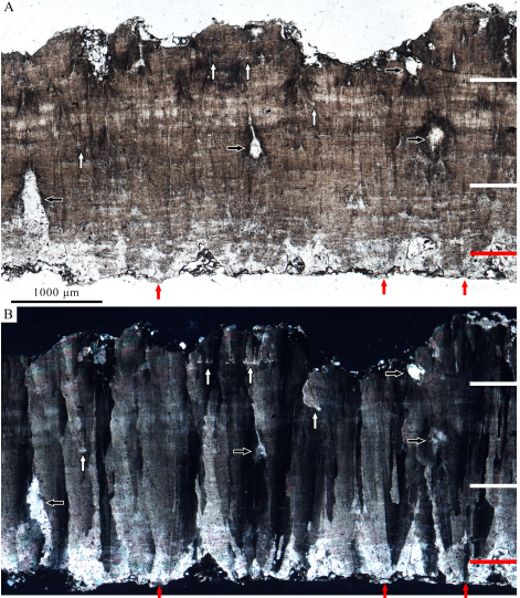
Sections of eggshell were selected for microscopic sections were cleaned by ultrasonic and embedded in resin for examination under a polarising light microscope. This revealed that the shells were between 2.76 and 2.97 mm, although this is probably less than the original thickness, due to weathering. They have a two-layered structure, with an outer cone layer 0.22–0.32 mm thick (roughly 10% total thickness) and an inner columnar layer 2.38 to 2.72 mm in thickness, which is typical of Dinosaur eggs. The inner columnar layer can in turn be divided into inner, medial and outer zones. The inner zone is 0.78 to 0.92 mm thick, which corresponds to about a third of the eggshell thickness. Areas of secondary growth can be found in the mdial and outer layers. The whole thickness is penetrated by worm-like pores.

Microstructure of the eggs in radial section (S221008-1②) under ordinary light (A) and cross-polarized light (B). White lines show the boundaries between the inner, medial and outer zones. (A) the boundary between the cone layer and columnar layer (red line) is not clear, accretion lines distribute through the shell, pore canals (black arrows) are irregular and worm-like, and the secondary eggshell units (white arrows) grow in the medial zone and the outer zone. (B) The eggshell units show radial extinction through the nucleation centres (red arrows) to the outer surface, and secondary eggshell units (white arrows) show independent radial extinction. Zhou et al. (2023).

Based upon this morphology, the eggs are assigned to the ichnospecies Coralloidoolithus shizuiwanensis, which has previously been described from the Xixia and Xichuan localities in Henan Province, and the Shanggao locality in Jiangxi Province, although the new specimens are slightly thicker than those previously assigned to this species. Although the egg-layer for Coralloidoolithus shizuiwanensis is unknown, the eggs are clearly Dinosaurian in origin, establishing the Moxia Formation as a Late Cretaceous rather than a Palaeogene deposit.

See also...

Online courses in Palaeontology

Follow Sciency Thoughts on Facebook.

Follow Sciency Thoughts on Twitter.


Sunday, 22 October 2023

A new Odonatan Insect from the Latest Triassic or Earliest Jurassic of Somerset, England.

Odonatopteran Insects, the group which includes the modern Damselflies and Dragonflies first appeared in the Carboniferous, with a variety of groups including the spectacular Griffenflies, Meganeuridae, which had wingspans of up to 71 cm, making them the largest flying Insects ever known to have lived. The crown group Odonata (a crown group includes all living members of a clade, the most recent common ancestor of all those members, and everything descended from that ancestor) first appeared in the Triassic, including the living Damselflies, Zygoptera, and Dragonflies, Anisoptera, as well as a number of extinct groups. One of these is the Liassophlebiidae, was first described in 1925 by palaeoentomologist Robin John Tillyard based upon specimens from the Late Triassic and Early Jurassic of Warwickshire and Worcestershire, England, which he assigned to the genus Liassophlebia. The Family Liassophlebiidae now includes five genera from the Triassic and Jurassic of Western Europe, Central Asia, and Antarctica, while the genus Liassophlebia includes five species from the Triassic of England and Jurssic of England and Germany.

In a paper published in the journal Historical Biology on 16 October 2023, Emily Swaby and Angela Coe of the School of Environment, Earth and Ecosystem Sciences, at the Open University, Deborah Hutchinson of the Bristol Museum & Art Gallery, Lee Riva of the Lovell Stone Group, and André Nel of the Institut de Systématique, Évolution, Biodiversité at the Muséum national d’Histoire naturelle, describe a new specimen of Liassophlebia from the White Lias Formation of Bowdens Quarry in Somerset, England.

The specimen was discovered at Bowdens Quarry in 2016 by Lee Riva, the quarry foreman, and subsequently donated to the Bristol Museum & Art Gallery. It comprises a split piece of fine-grained crystalline limestone with a partial forewing preserved as part and counterpart. Due to the fragmentary nature of this specimen it is ascribed to the genus Liassophlebia, but not to a specific species.

Liassophlebia sp., specimen BRSMG Cg3101 a+b: (A) BRSMG Cg3101 a, part; (B) BRSMG Cg3101 b, counterpart; (C) line drawing of BRSMG Cg3101 b, highlighting wing venation. Abbreviations: A×1, second branch of primary antenodal crossvein; CuA, anterior cubitus; DC, discoidal cell; MA, anterior median; MP , posterior median; N, nodus; Pt, pterostigma; RP3/4, third/fourth branch of posterior radius. Scale bars are 5 mm. Swaby et al. (2023).

The precise stratigraphic age of the deposits at Bowdens Quarry (and of the White Lias in general) is unclear. Bowdens Quarry comprises the uppermost part of the White Lias and the lowermost part of the overlying Blue Lias. Biostratigraphic data from the White Lias at Lavernock in Wales suggests that at least the uppermost part of the formation is Early Jurassic in age, whereas isotopic data from St Audrie’s Bay in Somerset suggests that the base of the White Lias coincides with the End Triassic Extinction Event (which actually comes slightly before the Triassic-Jurassic boundary, which is marked by the appearance of distinctly Jurassic forms during the post-extinction recovery).

(A) A geographic map highlighting the extent of Penarth Group in England and Wales (outcrop shown in purple), and location of Bowdens Quarry (red circle). Note that the outcrop has been simplified for clarity. B) Close-up of the study area (Langport, Somerset), indicating the location of Bowdens Quarry. (C) Simplified stratigraphic log of the Late Triassic-Early Jurassic succession from the Langport-Somerton area, showing the interval that BRSMG Cg3101 a+b came from. Based on lithology, the ‘lower’ White Lias is interpreted to be equivalent to the White Lias Formation on the Somerset coast and the ‘upper’ White Lias to the Watchet Mudstone Formation. MMG denotes the Mercia Mudstone Group and WL the White Lias. Swaby et al. (2023).

Robin John Tillyard described two species of LiassophlebiaLiassophlebia magnifica, from the Earliest Jurassic of Binton in Warwickshire, and Liassophlebia withersi, Latest Triassic of Strensham in Worcestershire. Unfortunately, Liassophlebia withersi was also described from extremely fragmentary material, so that, while it appears to come from a larger Insect that the new specimen, it cannot be confidently stated that the two are different species, with the effect that the new specimen does not help resolve the date of the White Lias at Bowdens Quarry.

An artist’s impression of Liassophlebia sp., resting on a frond of the Palaeofern species Phlebopteris muensteri. the forewings are based on the specimen BRSMG Cg3101 a+b. As the new specimen is incomplete, other specimens within the genera were used to create this artist’s impression as follows: the hindwing is based on the holotype specimen of Liassophlebia magnifica (NHMUK I.6648/I.10462); and the body proportions are based on the incomplete abdomens of the holotypes ‘Liassophlebiaclavigaster (NHMUK I.10433) and ‘Liassophlebiahopei (OUMNH J.55084 a and b). The colour and body morphology, including resting wing posture is inferred from present day Anisoptera. Jules Kiely/Bristol Museum & Art Gallery in Swaby et al. (2023).

See also...

Online courses in Palaeontology

Follow Sciency Thoughts on Facebook.

Follow Sciency Thoughts on Twitter.


Friday, 14 April 2023

Examining the impact of the Palaeocene–Eocene Thermal Maximum on sedimentation in the Gulf of Mexico.

Roughly 56 million years ago, global temperatures abruptly rose by 5-9°, leading to profound environmental changes across the planet, an event known as the Palaeocene–Eocene Thermal Maximum. This event was marked (and probably caused by) a sharp rise in atmospheric carbon dioxide, something marked in the rock record by a 3.0‰ negative carbon isotope excursion (three parts per thousand drop in the proportion of carbon¹³ to total carbon), which developed over a period of less than 5000 years. Three main stages to this negative carbon isotope extension have been detected; the onset, during which the proportion of carbon¹³ dropped from the pre-excursion level to the excursion level; the body, during which the proportion of carbon¹³ remained steady at the new, lower level; and the recovery, during which the proportion of carbon¹³ returned to the pre-excursion level.

This interval was also marked by a dramatic increase in the prevalence of the Dinoflagellate cyst Apectodinium spp., and a widespread dissolution of carbonates (a sign that the sea had become slightly acidic due to the higher atmospheric carbon dioxide levels). The negative carbon isotope excursion has been detected in a wide range of sedimentary setting, from continental interiors to ocean basins, although its cause is still debated. It is generally accepted that the rise in atmospheric carbon dioxide, combined with the drop in the proportion of carbon¹³, is indicative of the atmosphere receiving a sudden, and very large, input of carbon¹³-depleted carbon dioxide, with the most popular explanations for this being a volcanic source or a sudden increase in the proportion of carbon dioxide being released from land Plants and soils (this could be response to heating, leading to a feed-back loop in which the released carbon dioxide causes a rise in temperature, leading to further carbon dioxide being released, something which concerns climate scientists studying current rising global temperatures). It has also been suggested that the initial pulse of heating might have been caused by an increase in the proportion of biogenic methane (another potent greenhouse gas).

The Gulf of Mexico forms an enclosed basin within the area bounded by the southern coast of the United States, the east coasts of northern Mexico, and the Yucatan and Florida Peninsula. This basin formed by sea-flood spreading during the Jurassic and Early Cretaceous, with deposits of clasitic and carbonate sediments building up along its northern margin during the Cretaceous and Palaeocene. This sedimentation increased rapidly during the Palaeocene–Eocene Thermal Maximum, leading to a prograding  (movement of shoreline towards the sea) of the fluvio-deltaic Wilcox Group. During this time, most of what is now the southern United States formed a single catchment area, driven by the Laramide Orogeny as the Rocky Mountains began to form. The sedimentary material formed by erosion within this catchment was carried into the Gulf of Mexico, forming the deltas of the Houston, Mississippi, and Rio Grande rivers. These sediments served as a trap for hydrocarbons derived from organic material swept into these deltas, which has led to extensive hydrocarbon exploration of the basin in the twentieth and twenty first centuries. This data has enabled geologists to build up a good picture of sedimentation rates within the Gulf of Mexico throughout the Cainozoic, with a distinct increase on sedimentation rates visible at the Palaeocene–Eocene Thermal Maximum.

The Wilcox Group is a succession of fluvial, deltaic, and shallow marine sediments, which outcrops in parts of Alabama and Texas, where it is targeted by numerous onshore oil wells. The group progresses offshore, where its outer margins contain turbidite deposits, which are drilled by offshore oil rigs. The Wilcox Group can be divided into Lower, Middle, and Upper units, which the base of the Upper Unit marked by the Yoakum Shale, which is thought to mark the onset of the Palaeocene-Eocene boundary. The carbon isotope excursion associated with the Palaeocene–Eocene Thermal Maximum has been detected at several locations within the Wilcox Group, although principally within the onshore fluvial and deltaic deposits and the plains of the Gulf of Mexico. Within the distal part of the submarine fan, the Palaeocene–Eocene Thermal Maximum has been detected biostratigraphically, but not through the detection of the carbon isotope excursion. There is localized evidence of environmental change within the delta, recorded by prograding of sediments over an area of thousands of kilometers, with material from river drainages reaching to the deep ocean floor. 

The ability to connect a prograding deep sea fan to a well understood river catchment system provides a unique opportunity to study enviromental changes across an entire sedimentary system from the source to the outer part of the marine basin.

In a paper published in the journal Geology on 9 February 2023, Lucas Vimpere of the Department of Earth Sciences at the University of GenevaJorge Spangenberg of the Institute of Earth Surface Dynamics at the University of LausanneMarta Roige of the Departament de Geologia at the Universitat Autònoma de BarcelonaThierry Adatte of the Institute of Earth Sciences at the University of Lausanne, Eric De Kaenel of DeKaenel Paleo-Research, Andrea Fildani of the Deep Time Institute, Julian Clark and Swapan Sahoo of Equinor, Andrew Bowman of the Louisiana Geological SurveyPietro Sternai of the Dipartimento di Scienze dell’Ambiente e della Terra at the  Università degli Studi di Milano-Bicocca, and Sébastien Castelltort, also of the Department of Earth Sciences at the University of Geneva, present the results of a study that located the isotopic signal of the Palaeocene–Eocene Thermal Maximum within marine sediments in the northern part of the Gulf of Mexico, use this data to place a chronostratigraphic data-point within the strata, and examine the relationship between sedimentation rates and climate change as recorded within the sediments of the Gulf of Mexico.

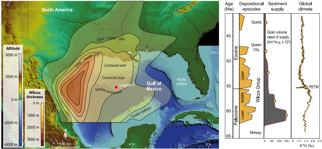
Vimpere et al. obtained a 543 m thick section from the Logan-1 ultra-deep-water wildcat well, which was sunk in 2011 on Walker Ridge Block, which includes the outer part of the Wilcox Group, about 400 km to the southeast of New Orleans. This well excavated a core beneath 2364 m of water, to a depth of 8351 m beneath sea level. One hundred and seventy eight samples were taken from this section, at three meter intervals, then subjected to bulk and clay X-ray diffraction, Rock-Eval pyrolysis, granulometric, organic carbon isotope, palynological, and calcareous nannofossil analyses.

Topobathymetric elevation model of North America showing the Logan-1 well location (drilled in 2011 on Walker Ridge Block 969, ID WR 969 ST0 #1) and present main geographic features. Depositional context during the Paleocene-Eocene transition is represented by Wilcox Group thickness and key tectono-stratigraphic events in the Gulf of Mexico sediment routing system. PETM; Palaeocene–Eocene Thermal Maximum. Vimpere et al. (2023).

Examination of palynomorphs and calcareous nanofossils identified the Palaeocene–Eocene Thermal Maximum interval as being present between  8181 and 8001 m within the Logan-1 core, and the  Palaeocene-Eocene boundary as lying between the NP9 and NP10-0 horizons of the calcareous nannofossil assemblage. The carbon-isotope excursion can also be identified within the core, at 8196–8001 m, with an onset 15 m below the Palaeocene-Eocene boundary, and no hiatus in sediment deposition. This pattern has been observed at a variety of locations, and suggests a link between the onset of the Palaeocene–Eocene Thermal Maximum and late Palaeocene volcanism on the e North Atlantic volcanic province, the Caribbean, and mid-ocean ridge areas. The main body interval of the carbon-isotope excursion is found between  8196 and 8108 m, and the recovery phase between 8108 and 8101 m. This gives a Palaeocene–Eocene Thermal Maximum deposit with a thickness of 195 m, making it the thickest Palaeocene–Eocene Thermal Maximum deposit yet discovered. This contrasts with other well cores sunk in the Gulf of Mexico, in which the Palaeocene–Eocene Thermal Maximum sequence has been truncated. A marked increase in the abundance of Dinoflagellate cyst Apectodinium spp. was observed at 8169 m, while glauconite concentrations increased at 8172 m. Both of these are thought to represent sediments having become condensed, and a shift in the shoreline to landward, caused by deepening sealevels associated with the global temperature rise. 

Carbon isotope, glauconite concentration, chronostratigraphic, and lithostratigraphic data and correlations with Gulf of Mexico standard stratigraphy for the section studied in the Logan-1 well (drilled in 2011 on Walker Ridge Block 969, ID WR 969 ST0 #1). δ13Corg measurements and three-point averages are illustrated by the circles and the curve, respectively. GR, gamma ray; Sh, shale; Slt, silt; Snd, sand; YS, Yoakum Shale; CIE, carbon isotope excursion; PETM, Palaeocene–Eocene Thermal Maximum. Nannofossils: Bomolithus aquilus, Discoaster araneus, Discoaster mahmoudii, Discoaster diastypus, Fasciculithus tympaniformis, Rhomboaster cuspis, Rhomboaster bitrifida, Tribrachiatus bramlettei, Discoaster mahmoudii, Coccolithus bownii, Bomolithus supremus, Tribrachiatus bramlettei, Thomsonipollis, Fasciculithus richardii, Caycedoae megastypus, Discoaster multiradiatus, Fasciculithus lillianiae, Fasciculithus richardii, Discoaster acutus. Vimpere et al. (2023).

These results suggest that, in this part of the Gulf of Mexico, sedimentation rates were significantly increased during the Palaeocene–Eocene Thermal Maximum. If the Palaeocene–Eocene Thermal Maximum is assumed to have lasted 170 000 years, then this part of the Gulf of Mexico apparently had an average sedimentation rate of 1.15 m per 1000 years during this interval. The main body of the event comprises 88 m of sediment, thought to have been laid down in 80 000 years, giving a sedimentation rate of 1.1 m per 1000 years, while the recovery period is represented by 107 m of sediment laid down in 118 000 years, giving a sedimentation rate of 1.18 m per 1000 years, although distinguishing the main body from the recovery period is difficult, leading to a substantial margin of error in these calculations.

The Yoakum Shale is considered to represent a maximum flooding surface, created when the Palaeocene–Eocene Thermal Maximum caused the shoreline to retreat by 150 m. In the submarine deposits of the Gulf Coastal Plain this corresponds with a drop in the amount of terrestrial sedimentary material arriving, and the formation of an number of submarine canyons, most notably the Yoakum Canyon off the coast of Texas. These canyons tended to funnel sediments down into the ocean basin, bypassing much of the continental shelf, which became starved of sediment. The sediments of the shelf show a higher proportion of marine palynomorphs (which settle out of the water column) than terrestrial palynomorphs (which are carried out to sea with sediment) during this interval, and are also enriched in glauconite (which only forms in marine settings) relative to the rest of the sediment column. 

Palaeographic map of the northern Gulf of Mexico showing evolution of the depositional systems throughout the Paleocene–Eocene Thermal Maximum. Vimpere et al. (2023).

It could be presumed that the heating and increase in sealevel associated with the Palaeocene–Eocene Thermal Maximum led to the transgression onto the shores of the Gulf of Mexicoby itself, however Vimpere et al.'s findings suggest that this was at least in part due to subsidance of the coastal margins associated with the formation of the submarine canyons, although there is not sufficient data to make an absolute assessment of the influence of the two phenomena.

During the Early Eocene, uplift associated with the second pulse of the Laramide Orgeny forced the waterways carrying sediments into the Gulf of Mexico to shift towards the southwest. This is recorded in the Upper Wilcox deposits, where several major fluvio-deltaic systems are rejuvinated. This in turn led to stabilization of the system, with less wandering by channels, enabling sediments to build up and prograde out over the shelf margin. This prograding of the delta sediments is matched by the development of a sandy apron in the deep sea basin, probably formed as the prograding sediments reached the head of the submarine canyons.

Schematic representation of the evolution of the sediment-routing system of North America throughout the Palaeocene–Eocene Thermal Maximum. Increased channel mobility and floodplain reworking led to preferential transport of clays into the basin (i.e., Yoakum Shale) through bypass of the shelf within submarine canyons. Upper Wilcox corresponds to resuming of preferential transport of coarse material into basin-floor aprons due to progradation of deltaic sands onto the shelf and the mud removal by waves. Vimpere et al. (2023).

Within the Logan-1 drill core the Yoakum Shale is overlain by a series of sandy beds which reach from the top of the Yoakum at 8120 m up to 8007 m. This is thought to be linked to the development of a more extreme climate, which switched periodically between intense drought phases and intervals of heavy precipitation. This created periodic heavy flows within the river basins, washing out to see accumulated sands, derived from rocks uplifted by the Laramide Orogeny. The inshore environment is also likely to have suffered an increase in storm and wave action, washing sediments from the delta lobes down into the deep ocean basin. 

Vimpere et al. were able to use a multi-disciplinary approach to locate the Palaeocene-Eocene boundary, Palaeocene–Eocene Thermal Maximum, and the associated carbon isotope excursion, in sediments about 400 km away from the nearest coast. The carbon isotope excursion here is 195 m thick, and confirmed to represent the Palaeocene–Eocene Thermal Maximum by palynological and microfossil analysis, making it the longest Palaeocene–Eocene Thermal Maximum section known. This implies that sedimentation rates in this part of the basin were extremely high during this interval, which in turn implies a strong sedimentological response to the changing hydrological conditions associated with the Palaeocene–Eocene Thermal Maximum. Since other fan deposits of equivalent age are known at many locations around the world, it is reasonable to assume that this was a global, rather than a regional, response to the Palaeocene–Eocene Thermal Maximum.

See also...

Follow Sciency Thoughts on Facebook.

Follow Sciency Thoughts on Twitter.


Sunday, 18 October 2020

Identifying fragmentary Mammal teeth from the Early Eocene of Ellesmere Island, Canada.

Lower Eocene (Wasatchian-aged) strata of the Margaret Formation, Eureka Sound Group on Ellesmere Island, Nunavut preserve evidence of lush mixed conifer-broadleaf rainforests inhabited by Alligators, Turtles, Birds, and at least 25 Mammalian genera. First discovered in 1975 near the head of Strathcona Fiord, the vertebrate fossils in the Eureka Sound Group are few, fragmentary and weather-worn, which can make it challenging to identify them. By far the most abundant and diverse Vertebrate fossils have come from the Margaret Formation cropping out on the Matthew peninsula between Bay and Strathcona fiords. Nearly a century before the first discovery of Eocene Vertebrate fossils on Ellesmere, Eocene Arctic forests were first documented when Sergeant David Brainard, a survivor of the ill-fated Greely Expedition of 1881–1883, discovered petrified logs on northeastern Ellesmere Island. Among the best preserved, extensive, and photogenic of the Eocene Arctic fossil forests is the Strathcona Fiord Fossil Forest, which preserves permineralised in situ tree stumps protruding from a prominent coal seam. The tree stumps are large, with diameters ranging from 40 cm to over a meter, and closely spaced, indicating a dense forest comparable to today’s Cypress swamps in the southern United States. Eocene Arctic palaeotemperature estimates using multiple proxies suggest a mean annual temperature of 5–17˚C, with winters above freezing and summer temperatures above 20˚C. Further, the Eocene Arctic rainforests had high mean annual precipitation and humidity, comparable with today’s temperate rainforests along the North American west coast.

In the summers of 2010 and 2018, Jaelyn Eberle of the Museum of Natural History and Department of Geological Sciences at the University of Colorado, David Eberth of the Royal Tyrrell Museum and team recovered tooth fragments belonging to a Mammal and small, undiagnostic bone fragments at the Strathcona Fiord Fossil Forest. As far as they are aware, these are the first Vertebrate fossils documented from this fossil forest. Most fossil Mammals can be identified to genus and often species by dental morphology. However, the tooth fragments from the Strathcona Fiord Fossil Forest are so incomplete as to be undiagnostic by using their external morphology. Therefore, Eberle et al. analysed the tooth enamel microstructure to assist in identifying the fossils. Mammalian prismatic enamel, the hardest and most resistant material in the body, consistently differs in its microstructure among clades of Perissodactyla (odd-toed ungulates), Rodentia, Proboscidea, in a paper published in the journal PLoS One on 23 September 2020, Jaelyn Eberle, Wighart von Koenigswald of the Institute of Geosciences at the Rheinische Friedrich-Wilhelms University, and David Eberth, demonstrate that the tooth fragments from the Strathcona Fiord Fossil Forest can be identified to genus based on their enamel microstructure. In so doing, they (1) document the first fossil Mammal from the Strathcona Fiord Fossil Forest; (2) help refine the age and correlation of this site within the context of the Margaret Formation elsewhere on Ellesmere Island; and (3) underscore the utility of tooth enamel microstructure in identifying Mammalian tooth fragments that cannot be identified by traditional palaeontologic means.

The tooth fragments described below were recovered from Locality P201088-2(NU) on central Ellesmere Island, along the southwestern coastal region of Strathcona Fiord. The general area, referred to as 'Strathcona Fiord', includes the first two fossil vertebrate sites that were discovered in the Canadian Arctic (Ellesmere Island) by Mary Dawson and her colleagues in the 1970s, approximately 10–12 km southeast and northeast of locality P201088-2(NU).

 
Map of Canada (inset) and satellite image showing location of the Strathcona Fiord study area and measured section. Eberle et al. (2020).

The sharp-based sandstone that hosts locality P201088-2(NU) occurs less than a meter above the top of an approximately 2 m thick coal that preserves an assemblage of in situ permineralised tree stumps and root balls coined the Strathcona Fiord Fossil Forest.

 
Images of the Strathcona Fiord Fossil Forest and fossil vertebrate site P201088-2(NU). (A) P201088-2(NU) is less than a meter stratigraphically above the coal containing the fossil forest; (B) and (C) show close-ups of petrified tree stumps in the fossil forest. Eberle et al. (2020).

Vertebrate fossils in the Strathcona Fiord region produce from the Eureka Sound Group, which consists of four formations in this area. In ascending order, these are the Mount Bell, Mount Lawson, Mount Moore, and Margaret formations. The stratigraphic section that Eberle et al. examined and measured at Strathcona Fiord consists of the uppermost exposures of the fine-grained marine Mount Moore Formation, overlain by non-coaly to coaly, paralic-to-non-marine deposits of the lower Margaret Formation. Eberle et al. place locality P201088-2(NU) approximately 316 m above the base of the multi-kilometer-thick Margaret Formation. Based on thickness data Eberle et al. regard this position as occurring in the lower portion of the Margaret Formation. Beds in this portion of the section are exposed along an extensive north-south trending ridge, and dip steeply (25˚–35˚) to the west. Lastly, Eberle et al. note that during stratigraphic measurement and examination in their study area, they identified errors in formation identification on the geologic map. Specifically, previous authors had erroneously mapped the Strathcona Fiord Fossil Forest and its thick coal as part of the Mount Lawson Formation, which instead is a Palaeocene-aged marine mudstone succession in the lower half of the Eureka Sound Group.

 
Strathcona Fiord Section showing stratigraphic level of fossil vertebrate locality P2011088-2 (NU) and Strathcona Fiord Fossil Forest in the coal directly below it. Eberle et al. (2020).

Strathcona Fiord fossil vertebrate sites have previously been interpreted as early Eocene (Wasatchian) in age. Based on these interpretations and stratigraphic patterns, Eberle et al. suggest the age of the Strathcona Fiord Fossil Forest and locality P201088-2(NU) is also Wasatchian, equivalent in time to the lower Margaret Formation interval at Bay Fiord (about 25 kilometers to the north-northeast).

Locality P201088-2(NU) occurs just above the stratigraphic horizon where the Margaret Formation paralic succession (complexly and thinly interbedded marine to non-marine strata) transitions up-section into a 50 m thick succession of strictly non-marine, coastal-plain strata dominated by fine sandstones and minor coals. Exposures of the lower Margaret Formation at Bay Fiord record a similar pattern of overall regression and are characterized by an upsection transition from paralic to coaly coastal plain deposits. The host sandstone for locality P201088-2(NU) exhibits ripple laminae and abundant coalified root traces, the latter indicating that a stable and likely subaerial substrate was present for Plant colonisation subsequent to deposition of the sandstone. Sparse occurrences of fossil Vertebrate fragments are present among mudstone and ironstone intraclasts in the sandstone, suggesting that lower portions of the sandstone may have been deposited as a lag deposit during waning flow. Angiosperm and Gymnosperm leaf fragments, and more root traces are common in the uppermost portions of the host sandstone, again suggesting substrate stability between subsequent later-stage sediment accumulation events.

No other intervals were observed lower in section that preserve well-developed associations of ‘fossil forests,’ ironstone and fossil Vertebrate clasts, rooted horizons, fossil leaves, and an absence of marine indicators. Furthermore, the presence of the fossil forest, multiple rooted horizons, leaf fossils, and ironstone and fossil bioclasts (the tooth fragments) all suggest forested conditions, exposed substrates, and incipient soil formation in a well-saturated setting subjected to episodic flooding. Accordingly, Eberle et al. interpret this transitional stratigraphic interval as recording an up-section shift from frequently flooded paralic shoreline settings to a relatively more up-dip coastal-plain setting where non-marine conditions prevailed. This palaeoenvironmental interpretation matches those previous hypothesised for the Margaret Formation that describe upward-coarsening cycles of interbedded cross-bedded sandstone, siltstone, mudstone, and coal. These are interpreted as proximal delta-front to delta-plain palqeoenvironments characterised by abundant shoreline sands, alluvial to estuarine channels, coal swamps, lagoons and bays, and well-forested, low-gradient interfluves.

Nunavut Fossil Vertebrate (i.e., NUFV) 2092B and 2092E, the tooth fragments analysed in Eberle et al.'s study, were collected along with approximately 20 other tooth fragments and several small, weathered bone fragments by Jaelyn Eberle, David Eberth, and team in July 2010 and by Jaelyn Eberle in July 2018 at locality P201088-2(NU). The fossils were collected on Class 2 Nunavut Territory Palaeontologist Permits 2010-003P and 2018-02P issued by the Nunavut Department of Culture and Heritage. Detailed coordinates for locality P201088-2(NU) are on file at the Nunavut Department of Culture and Heritage in Iqaluit and the Canadian Museum of Nature in Ottawa, Canada.

 
Tooth fragments from locality P201088-2(NU) at the Strathcona Fiord Fossil Forest site on central
Ellesmere Island, Nunavut. (A) NUFV 2092B. (B) NUFV 2092E. Eberle et al. (2020).

Given their similarity in thickness and external appearance, and the fact that they were recovered near one another, the tooth fragments probably represent the same taxon and individual. Based upon their thickness, NUFV 2092B and 2092E are from a relatively large Mammal. However, their external morphology does not allow us to reliably identify the Mammal to which they belong. Therefore, Eberle et al. decided to study the enamel microstructure. To investigate the microstructure of NUFV 2092B and 2092E, three traditional planes of section were studied, the horizontal (or transverse), vertical, and tangential sections.

 
Orientation of the three traditional planes of section used to study mammalian tooth enamel microstructure from. Eberle et al. (2020).

NUFV 2092B and 2092E were studied under a light microscope to orient the specimens and determine the direction of the occlusal surface. The specimens were subsequently embedded in epoxy resin, and oriented so that the desired sections (horizontal, vertical, or tangential) were placed parallel to the resin surface. The embedded specimens were left for 48 hours at room temperature under a fume hood to allow the epoxy to harden. NUFV 2092B was cut using an Isomet© low-speed saw with 0.3 mm blade thickness, to produce horizontal and vertical sections, whereas NUFV 2092E was used for the tangential section. The specimens were ground in three steps. First, they were ground down to the enamel surface using a grinding wheel (grit 240). Next, handgrinding was done on fine wet sandpaper (grit 800) placed over a glass sheet, and finally the specimens were ground with fine powder grit (grit 1000) mixed with water on a glass plate. Between each of these steps, the specimens were analysed under a light microscope to ensure that grinding was not too extensive. The ground surfaces were rinsed with water, cleaned in an ultrasonic cleaner, blown dry, and etched with 10% hydrochloric acid for approximately three seconds.

Prior to scanning electron microscope analysis, the specimens were sputter-coated with gold or palladium. Scanning electron microscope analysis was conducted on a Camscan MV 2300 instrument in the Palaeontology Section of the Institute of Geosciences and a Cambridge Stereoscan 200 scanning electron microscope in the Institut für Biodiversität der Pflanzen at the Rheinische Friedrich-Wilhelms University in Bonn, Germany.

In describing the enamel microstructure of NUFV 2092B and 2092E, Eberle et al. define the units by their size and level of complexity. First, they describe the crystallites, the smallest units of enamel that are comprised of fine needles of hydroxyapatite with a diameter of less than 0.5 μm and length of more than 100 μm. Crystallites are visible under high magnification (1500x and higher). Next, Eberle et al. describe the prisms that are made up of bundles of crystallites surrounded by a prism sheath. The size and shape of the prisms differ among clades of Mammals. Prisms form at the enamel-dentine junction and grow almost to the outer enamel surface. They are typically arranged in groups or bands with the same prism orientation. Their orientation defines the various enamel types. The prismatic enamels of Mammals often have two or more different enamel types. The most primitive enamel type among placental Mammals is radial enamel, in which the prisms’ long axes parallel one another and extend radially from near the enamel-dentine junction towards the outer enamel surface. More complex enamel types occur in which bands of prisms change their orientations from the enamel-dentine junction to the outer enamel surface. Among the most often described enamel types are Hunter-Schreger bands, which are light and dark stripes often seen under a light microscope. Hunter-Schreger bands are an optical phenomenon caused by the different prism orientation in alternating bands, forming decussations. Hunter-Schreger bands occur in the enamel of most large Mammals and often are arranged horizontally. However, a few taxa, including Rhinocerotoids, have vertical Hunter-Schreger bands. Hunter-Schreger bands function as a crack-stopping device. The level above the enamel type is the schmelzmuster, the three-dimensional distribution of enamel types within the enamel that has both biomechanical and phylogenetic controls. The number of possible combinations of enamel types or schmelzmusters is very large.

By studying the horizontal, vertical, and tangential sections of NUFV 2092B and 2092E, Eberle et al. discovered a complex enamel microstructure that was challenging to interpret solely through scanning electron microscope analysis. Consequently, they also studied NUFV 2092B and 2092E at lower magnification under a light microscope using the light-guide effect. If light hits an enamel prism approximately perpendicular to its axis, the light is reflected and the prism appears light in color. If, however, the light hits a prism parallel to its long axis, it disappears into the prism, and the prism appears dark. When the source of illumination is changed from one direction to another, bands that were dark in one will be light in the other, and vice versa. The light and dark bands, each comprised of many prisms with the same orientation, are the Hunter-Schreger bands. Eberle et al. used a combination of the light-guide effect and scanning electron microscope analysis to study the enamel microstructure of NUFV 2092B and 2092E.

Based upon thickness, NUVF 2092B and 2092E belong to a relatively large Mammal. The shiny outer surface of the enamel is covered by ridges and crenulations that extend vertically and diagonally at a steep angle. Of the diverse Mammalian fauna known from the early Eocene Arctic, the Pantodont Coryphodon is among the largest and best represented by fossils, and the enamel on its teeth has vertical ridges and wrinkles. However, these characters are not unique to Coryphodon. Many Mammals, including Brontotheres that also are known from the Eocene Arctic, show varying amounts of rugosity and crenulations on the external surface of the enamel.

Others have noted the appearance of vertical stripes in the tangential section of the enamel of Coryphodon as well as ridges on the shearing crests of its molars, indicating the presence of vertical structures within the enamel. On the occlusal surface of NUFV 2092B, there are weak ridges, and when the tangential section of the enamel is illuminated from one side, faint vertical light and dark stripes are visible. However, these characters also are not restricted to Coryphodon, but occur in Rhinocerotoids and some extinct South American Mammals including Pyrotheres and Astrapotheres.

Coryphodon, however, is characterised by a unique and complex enamel microstructure coined Coryphodon-enamel. NUFV 2092B and 2092E were analysed at low and high magnifications under both a light microscope and scanning electron microscope to determine whether Coryphodon-enamel is present. Eberle et al. describe the crystallites, prisms, and schmelzmuster of the NUFV specimens, and compare them to the enamel microstructure of Coryphodon, Rhinocerotoids and other large Mammals known from the Eocene Arctic.

The cross sections of prisms are best seen in the tangential section. Individual crystallites are visible at high magnification, where they appear as fine needles making up the prisms and interprismatic matrix. The crystallites in the prisms appear approximately parallel to those comprising the interprismatic matrix, which is found in the enamel of Coryphodon. Most of the prisms in NUFV 2092E are rounded and have an open prism sheath, although there is some variability in shape, with some prisms being more oblong and narrowing towards the top. The prisms range in diameter from approximately 4–7 μm and the prism sheaths are open towards the base of the tooth or to one side. A horseshoe-shaped prism sheath was noted for Coryphodon, although it is not restricted to the genus. Although close together, the prism sheaths do not appear to touch one another. Rather, a thin (roughly 1–2 μm) layer of interprismatic matrix surrounds the prism sheaths and appears as a ‘tail’ below each prism that tapers towards the base of the tooth or to the side.

 
Scanning electron microscope images of the tangential section of NUFV 2092E. (A) Cross-section through prisms; the prism sheath is dark and looks like a trench around each prism because it has been etched away. (B) Close-up of prisms and interprismatic matrix which are comprised of fine, needle-like crystallites. P, prism. Eberle et al. (2020).

The combined interpretation of the transverse, vertical, and tangential sections of NUFV 2092B and 2092E indicates that the enamel microstructure is dominated by elongate, steeply dipping or near vertical bodies of prisms that penetrate the enamel almost from the enamel-dentine junction towards the outer enamel surface, leaving thin inner and outermost zones.

Next to the enamel-dentine junction, there is a thin inner zone of radial enamel in some places. However, in other areas next to the enamel-dentine junction the prisms do not appear to run parallel to one another, and it is difficult to discern a pattern.

The middle zone, which comprises the greatest thickness of enamel, is made up of a complex enamel wherein elongate bodies of variable thickness extend outward from the enamel-dentine junction towards the outer enamel surface. At higher magnification, the elongate bodies are Hunter-Schreger band-like in that they are comprised of steeply-dipping or rising prisms, and are separated from one another by transitional zones of horizontal (or nearly so) prisms. The nearly vertical orientation of the elongate bodies becomes obvious in the tangential section (discussed below). However, in contrast to Hunter-Schreger bands that are identified in many large Mammals, the elongate bodies and intervening transitional zones are not of uniform thickness or spacing from one another in NUFV 2092B.

 
Scanning electron microscope image of enamel of NUFV 2092B in horizontal section. (A) Three enamel zones are evident; a very thin Inner Zone of radial enamel (in some places), a thick Middle Zone comprised of elongate bodies of prisms, and a thin Outer Zone. (B) Higher magnification scanning electron microscope image showing area outlined by white square in (A); elongate bodies (eb) are comprised of steeply-dipping or rising prisms, and are separated from one another by transitional zones (tz) made up of horizontal (or nearly so) prisms. Irregular-shaped grains on scanning electron microscope images are an artifact of sample preparation process. Eberle et al. (2020).

Based on the tangential section, Eberle et al. predict that the nested chevrons should appear in cross section as vertical elongate bodies with variable thicknesses and branches, depending upon where the horizontal section transects them. Further, Eberle et al. predict that they should be concentrated in the inner region of the middle zone of enamel. Whereas, in the outer region of the middle zone (towards the outer enamel surface) in horizontal section, Eberle et al. hypothesise that the elongate bodies should be broader in appearance, and the nested chevron structures should all but disappear in the outermost zone of enamel. In fact, the horizontal section appears to show just that, the outer region of the middle enamel zone shows broader bodies that transition in places into radial enamel near the outer enamel surface.

 
Uncoated tangential section of NUFV 2092E under a light microscope (A) and higher magnification (B). In both images, occlusal surface is towards the top and source of light is from the bottom. EDJ, Enamel-Dentine Junction; OES, outer enamel surface. Eberle et al. (2020).

Evident in vertical sections of NUFV 2092B, an outer zone of radial enamel in which the prisms run parallel to each other lies near the outer enamel surface. In some areas, it may be up to 300 μm in thickness, whereas in other areas it is much thinner, and the microstructures of the thick middle zone extend nearly to the outer enamel surface. In some areas adjacent to the outer enamel surface, the prism sheath vanishes between the parallel-oriented prisms, so that these merge into a prismless outer enamel zone, a feature observed in a number of Mammalian taxa. In other areas, the enamel contains large vacuities, probably the result of diagenesis.

 
Scanning electron microscope images of vertical section of outer zone of NUFV 2092B (A) and (B), and uncoated tangential sections of NUFV 2092B (C) and Yukon Government (YG) 514.12 (D), rhinocerotoid enamel from [26]. In (A) the region outlined by white square is magnified in (B). OES, outer enamel surface. (C) Magnified uncoated tangential section of NUFV 2092E under a light microscope, compared to (D) uncoated tangential section of YG514.12, enamel of a Miocene Rhinocerotoid from the Yukon, Canada under a light microscope. Eberle et al. (2020).

In summary, the analysis of NUFV 2092B and 2092E in horizontal, tangential, and vertical sections at both low and high magnification indicates that the enamel is characterized by elongate, vertical bodies extending from near the enamel-dentine junction towards the outer enamel surface that are made up of steeply-angled prisms that decussate with adjacent bodies. The inner region of the middle enamel zone contains nested chevron or treelike structures that are evident in horizontal and tangential sections, whereas in the outer region, the vertical bands become broader and the nested chevron structures are lost. An outer zone of radial enamel or prismless outer enamel zone occurs next to the outer enamel surface.

The enamel microstructure that occurs in NUFV 2092B and 2092E is comparable to that of the Pantodont Coryphodon. Coined 'Coryphodon-enamel', this enamel type is characterised by vertical or oblique structures that in tangential section appear as light-colored bands of nested chevrons or treelike structures separated from one another by similar, though narrower, dark-colored bands. The difference in width between the light and dark stripes when light is reflected from one direction indicates that the prism orientation is not symmetrical. Also like Coryphodon-enamel (although not restricted to it), NUFV 2092B and 2092E have an outermost zone of radial enamel, as well as rounded prisms that open to one side and are surrounded by interprismatic matrix that is nearly parallel to the prisms. Given the suite of characters shared with Coryphodon-enamel, but predominantly the vertical bodies that manifest as lines of nested chevrons or treelike structures in tangential view, NUFV 2092B and 2092E possess Coryphodon-enamel. However, does Coryphodon-enamel occur in any of the other large Mammals known from the Arctic localities?

In the Canadian Arctic, Rhinocerotoids are known from early Miocene sediments of the Haughton Formation on Devon Island and from the Yukon. Rhinocerotoids have vertical Hunter-Schreger bands in their tooth enamel that look somewhat like the vertical elements in Coryphodon-enamel. However, the vertical bands in Rhinocerotoid enamel contrast with those in Coryphodon-enamel in that they are of consistent thickness and spacing from one another and separated by thin transitional zones of 2–3 prisms wide. In tangential section, Rhinocerotoid enamel shows light and dark vertical lines that bifurcate in a regular pattern and lack the nested chevron or treelike structures in Coryphodon-enamel.

Although not nearly as regular in pattern as the vertical Hunter-Schreger bands in Rhinocerotoids, Coryphodon-enamel nevertheless cannot be considered irregular enamel. This enamel type, which occurs in Proboscideans (Elephants and their extinct relatives) and some Rodents, is characterised by prisms that twist irregularly in bundles or as single prisms around each other, and bundles of prisms show a range of angles and attitudes with no consistent pattern.

The Brontotheres cf. Eotitanops and Palaeosyops are documented from Early-Middle Eocene rocks of the Margaret Formation on Ellesmere Island, and tooth fragments from a larger, younger Brontothere were recovered from middle Eocene strata of the Buchanan Lake Formation on nearby Axel Heiberg Island. However, Brontothere tooth enamel differs from Coryphodon-enamel in having U-shaped Hunter-Schreger bands, an intermediate condition between the horizontal Hunter-Schreger bands found in most large Mammals and the vertical Hunter-Schreger bands of Rhinocerotoids. Tapiroids occur at Early Eocene localities in the Margaret Formation. However, Tapiroids have horizontal to curved Hunter-Schreger bands.

The nested chevron pattern seen in the tangential section of Coryphodon-enamel is reminiscent of the zigzag Hunter-Schreger bands found in advanced Carnivorans, particularly Crocuta crocuta (Hyaena) that correlate with ossiphagous (or bone-eating) habits. However, the enamel of Crocuta crocuta differs from Coryphodon-enamel in that the vertical structures show a symmetrical pattern when illuminated from opposing directions in tangential section, and the vertical light and dark bands are of similar thickness.

Several Carnivoromorpha are known from the Margaret Formation, but their enamel shows significant differences from Coryphodon-enamel. Miacis, cf. Vulpavus, and Viverravus are small-bodied members of Carnivoromorpha whose tooth enamel is much thinner (and smoother) than that of NUFV 2092B and 2092E. Further, the tooth enamel of these early Eocene Carnivores contains undulating Hunter-Schreger bands, which are essentially horizontal, slightly wavy Hunter-Schreger bands. The Oxyaenid Palaeonictis and Mesonychid Pachyaena are the largest Carnivores in the Margaret Formation, although their fossils are rare, with each taxon represented by a single fossil in the Arctic. The enamel of these taxa has undulating Hunter-Schreger bands in the lower half of the tooth that transitions into zigzag Hunter-Schreger bands in the upper one-half to one-third of the tooth. Coryphodon-enamel altogether lacks undulating Hunter-Schreger bands. In addition to its namesake, Coryphodon-enamel is known to occur in middle Eocene Uintatherium and late Eocene Entelodon, neither of which is known from the early Eocene nor from the polar region. Therefore, it is unlikely that the Coryphodon-enamel reported here from the Strathcona Fiord Fossil Forest belongs to any other Mammal besides Coryphodon.

The tooth enamel fragments reported here, along with some poorly preserved bone fragments, thus far are the only documented vertebrate fossils from the Strathcona Fiord Fossil Forest. However, Coryphodon fossils occur elsewhere in the Margaret Formation on Ellesmere Island, so its presence at the Strathcona Fiord Fossil Forest is not surprising. What is novel in Eberle et al.'s study is the way in which they identify the fossils NUFV 2092B and 2092E to Coryphodon by way of their enamel microstructure. Complete Mammalian teeth and jaws are morphologically diagnostic and readily identified to genus and even species. However, in the Arctic, Eocene Vertebrate fossils are rare, and many are fragmentary. Eberle et al. provide an example of how enamel microstructure can be used to identify the Mammal.

The presence of Coryphodon suggests that the strata containing the Strathcona Fiord Fossil Forest are temporally correlative with the early Eocene (Wasatchian) fossil-bearing strata of the Margaret Formation approximately 25 km further north at Bay Fiord, a conclusion reached independently by lithologic correlation. At Bay Fiord, Perissodactyls, Hyaenodontid Creodonts, Miacis, and cf. Vulpavus, all of which first appear at mid-latitudes in the Wasatchian, as well as the Wasatchian index taxon Pachyaena and the archaic Ungulate Anacodon, which last appears in the Wasatchian, occur in the lower faunal level of the Margaret Formation. Although Coryphodon occurs at early middle Eocene (Bridgerian) localities at mid-latitudes, it is restricted to the early Eocene (Wasatchian) faunal assemblage in the Arctic. The strata containing the Strathcona Fiord Fossil Forest were initially mapped as the Late Paleocene Mount Lawson Formation of the Eureka Sound Group. However, Eberle et al.'s study indicates that they should be re-mapped as the Margaret Formation on the basis of lithology, palaeoenvironmental interpretations, and the presence of Coryphodon.

Vertical elements such as those found in the enamel of the Carnivore Crocuta (Hyaena) and Entelodonts are hypothesised to be an adaptation to deal with high stresses during mastication/ Crocuta is carnivorous and ossiphagous, whereas Entelodonts have been interpreted as omnivores and Pig-like in their diet, ingesting a variety of food items, including plants, meat, and bones. In contrast, Coryphodon, based on its transverse shearing lophs and carbon isotope values, is interpreted as an herbivore, and probably semiaquatic. Based on its oxygen and carbon isotope values, Coryphodon is inferred to be a year-round resident above the Arctic Circle and therefore experienced months of darkness and the shutdown of photosynthesis during the polar winter. Seasonal isotopic variations, and specifically high winter proportional carbon¹³ values in the enamel of Coryphodon teeth from Ellesmere Island, suggest a varied diet during the dark winter that probably included wood, leaf litter, and evergreen Conifers. The presence of vertical elements in the enamel microstructure of Coryphodon may have pre-adapted these large Mammals to ingesting tough, poorer quality food items during the long dark winters above the Arctic Circle. This could partly explain why Coryphodon is the most abundant herbivore in the Eocene Arctic.

See also...


Online courses in Palaeontology. 

Follow Sciency Thoughts on Facebook.

Follow Sciency Thoughts on Twitter