Showing posts with label Offshore Drilling. Show all posts

Friday, 14 April 2023

Examining the impact of the Palaeocene–Eocene Thermal Maximum on sedimentation in the Gulf of Mexico.

Roughly 56 million years ago, global temperatures abruptly rose by 5-9°, leading to profound environmental changes across the planet, an event known as the Palaeocene–Eocene Thermal Maximum. This event was marked (and probably caused by) a sharp rise in atmospheric carbon dioxide, something marked in the rock record by a 3.0‰ negative carbon isotope excursion (three parts per thousand drop in the proportion of carbon¹³ to total carbon), which developed over a period of less than 5000 years. Three main stages to this negative carbon isotope extension have been detected; the onset, during which the proportion of carbon¹³ dropped from the pre-excursion level to the excursion level; the body, during which the proportion of carbon¹³ remained steady at the new, lower level; and the recovery, during which the proportion of carbon¹³ returned to the pre-excursion level.

This interval was also marked by a dramatic increase in the prevalence of the Dinoflagellate cyst Apectodinium spp., and a widespread dissolution of carbonates (a sign that the sea had become slightly acidic due to the higher atmospheric carbon dioxide levels). The negative carbon isotope excursion has been detected in a wide range of sedimentary setting, from continental interiors to ocean basins, although its cause is still debated. It is generally accepted that the rise in atmospheric carbon dioxide, combined with the drop in the proportion of carbon¹³, is indicative of the atmosphere receiving a sudden, and very large, input of carbon¹³-depleted carbon dioxide, with the most popular explanations for this being a volcanic source or a sudden increase in the proportion of carbon dioxide being released from land Plants and soils (this could be response to heating, leading to a feed-back loop in which the released carbon dioxide causes a rise in temperature, leading to further carbon dioxide being released, something which concerns climate scientists studying current rising global temperatures). It has also been suggested that the initial pulse of heating might have been caused by an increase in the proportion of biogenic methane (another potent greenhouse gas).

The Gulf of Mexico forms an enclosed basin within the area bounded by the southern coast of the United States, the east coasts of northern Mexico, and the Yucatan and Florida Peninsula. This basin formed by sea-flood spreading during the Jurassic and Early Cretaceous, with deposits of clasitic and carbonate sediments building up along its northern margin during the Cretaceous and Palaeocene. This sedimentation increased rapidly during the Palaeocene–Eocene Thermal Maximum, leading to a prograding  (movement of shoreline towards the sea) of the fluvio-deltaic Wilcox Group. During this time, most of what is now the southern United States formed a single catchment area, driven by the Laramide Orogeny as the Rocky Mountains began to form. The sedimentary material formed by erosion within this catchment was carried into the Gulf of Mexico, forming the deltas of the Houston, Mississippi, and Rio Grande rivers. These sediments served as a trap for hydrocarbons derived from organic material swept into these deltas, which has led to extensive hydrocarbon exploration of the basin in the twentieth and twenty first centuries. This data has enabled geologists to build up a good picture of sedimentation rates within the Gulf of Mexico throughout the Cainozoic, with a distinct increase on sedimentation rates visible at the Palaeocene–Eocene Thermal Maximum.

The Wilcox Group is a succession of fluvial, deltaic, and shallow marine sediments, which outcrops in parts of Alabama and Texas, where it is targeted by numerous onshore oil wells. The group progresses offshore, where its outer margins contain turbidite deposits, which are drilled by offshore oil rigs. The Wilcox Group can be divided into Lower, Middle, and Upper units, which the base of the Upper Unit marked by the Yoakum Shale, which is thought to mark the onset of the Palaeocene-Eocene boundary. The carbon isotope excursion associated with the Palaeocene–Eocene Thermal Maximum has been detected at several locations within the Wilcox Group, although principally within the onshore fluvial and deltaic deposits and the plains of the Gulf of Mexico. Within the distal part of the submarine fan, the Palaeocene–Eocene Thermal Maximum has been detected biostratigraphically, but not through the detection of the carbon isotope excursion. There is localized evidence of environmental change within the delta, recorded by prograding of sediments over an area of thousands of kilometers, with material from river drainages reaching to the deep ocean floor. 

The ability to connect a prograding deep sea fan to a well understood river catchment system provides a unique opportunity to study enviromental changes across an entire sedimentary system from the source to the outer part of the marine basin.

In a paper published in the journal Geology on 9 February 2023, Lucas Vimpere of the Department of Earth Sciences at the University of Geneva, Jorge Spangenberg of the Institute of Earth Surface Dynamics at the University of Lausanne, Marta Roige of the Departament de Geologia at the Universitat Autònoma de Barcelona, Thierry Adatte of the Institute of Earth Sciences at the University of Lausanne, Eric De Kaenel of DeKaenel Paleo-Research, Andrea Fildani of the Deep Time Institute, Julian Clark and Swapan Sahoo of Equinor, Andrew Bowman of the Louisiana Geological Survey, Pietro Sternai of the Dipartimento di Scienze dell’Ambiente e della Terra at the  Università degli Studi di Milano-Bicocca, and Sébastien Castelltort, also of the Department of Earth Sciences at the University of Geneva, present the results of a study that located the isotopic signal of the Palaeocene–Eocene Thermal Maximum within marine sediments in the northern part of the Gulf of Mexico, use this data to place a chronostratigraphic data-point within the strata, and examine the relationship between sedimentation rates and climate change as recorded within the sediments of the Gulf of Mexico.

Vimpere et al. obtained a 543 m thick section from the Logan-1 ultra-deep-water wildcat well, which was sunk in 2011 on Walker Ridge Block, which includes the outer part of the Wilcox Group, about 400 km to the southeast of New Orleans. This well excavated a core beneath 2364 m of water, to a depth of 8351 m beneath sea level. One hundred and seventy eight samples were taken from this section, at three meter intervals, then subjected to bulk and clay X-ray diffraction, Rock-Eval pyrolysis, granulometric, organic carbon isotope, palynological, and calcareous nannofossil analyses.
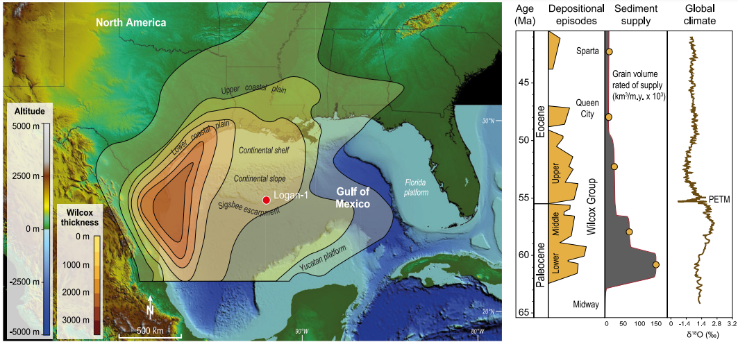
Topobathymetric elevation model of North America showing the Logan-1 well location (drilled in 2011 on Walker Ridge Block 969, ID WR 969 ST0 #1) and present main geographic features. Depositional context during the Paleocene-Eocene transition is represented by Wilcox Group thickness and key tectono-stratigraphic events in the Gulf of Mexico sediment routing system. PETM; Palaeocene–Eocene Thermal Maximum. Vimpere et al. (2023).

Examination of palynomorphs and calcareous nanofossils identified the Palaeocene–Eocene Thermal Maximum interval as being present between  8181 and 8001 m within the Logan-1 core, and the  Palaeocene-Eocene boundary as lying between the NP9 and NP10-0 horizons of the calcareous nannofossil assemblage. The carbon-isotope excursion can also be identified within the core, at 8196–8001 m, with an onset 15 m below the Palaeocene-Eocene boundary, and no hiatus in sediment deposition. This pattern has been observed at a variety of locations, and suggests a link between the onset of the Palaeocene–Eocene Thermal Maximum and late Palaeocene volcanism on the e North Atlantic volcanic province, the Caribbean, and mid-ocean ridge areas. The main body interval of the carbon-isotope excursion is found between  8196 and 8108 m, and the recovery phase between 8108 and 8101 m. This gives a Palaeocene–Eocene Thermal Maximum deposit with a thickness of 195 m, making it the thickest Palaeocene–Eocene Thermal Maximum deposit yet discovered. This contrasts with other well cores sunk in the Gulf of Mexico, in which the Palaeocene–Eocene Thermal Maximum sequence has been truncated. A marked increase in the abundance of Dinoflagellate cyst Apectodinium spp. was observed at 8169 m, while glauconite concentrations increased at 8172 m. Both of these are thought to represent sediments having become condensed, and a shift in the shoreline to landward, caused by deepening sealevels associated with the global temperature rise. 

Carbon isotope, glauconite concentration, chronostratigraphic, and lithostratigraphic data and correlations with Gulf of Mexico standard stratigraphy for the section studied in the Logan-1 well (drilled in 2011 on Walker Ridge Block 969, ID WR 969 ST0 #1). δ13Corg measurements and three-point averages are illustrated by the circles and the curve, respectively. GR, gamma ray; Sh, shale; Slt, silt; Snd, sand; YS, Yoakum Shale; CIE, carbon isotope excursion; PETM, Palaeocene–Eocene Thermal Maximum. Nannofossils: Bomolithus aquilus, Discoaster araneus, Discoaster mahmoudii, Discoaster diastypus, Fasciculithus tympaniformis, Rhomboaster cuspis, Rhomboaster bitrifida, Tribrachiatus bramlettei, Discoaster mahmoudii, Coccolithus bownii, Bomolithus supremus, Tribrachiatus bramlettei, Thomsonipollis, Fasciculithus richardii, Caycedoae megastypus, Discoaster multiradiatus, Fasciculithus lillianiae, Fasciculithus richardii, Discoaster acutus. Vimpere et al. (2023).

These results suggest that, in this part of the Gulf of Mexico, sedimentation rates were significantly increased during the Palaeocene–Eocene Thermal Maximum. If the Palaeocene–Eocene Thermal Maximum is assumed to have lasted 170 000 years, then this part of the Gulf of Mexico apparently had an average sedimentation rate of 1.15 m per 1000 years during this interval. The main body of the event comprises 88 m of sediment, thought to have been laid down in 80 000 years, giving a sedimentation rate of 1.1 m per 1000 years, while the recovery period is represented by 107 m of sediment laid down in 118 000 years, giving a sedimentation rate of 1.18 m per 1000 years, although distinguishing the main body from the recovery period is difficult, leading to a substantial margin of error in these calculations.

The Yoakum Shale is considered to represent a maximum flooding surface, created when the Palaeocene–Eocene Thermal Maximum caused the shoreline to retreat by 150 m. In the submarine deposits of the Gulf Coastal Plain this corresponds with a drop in the amount of terrestrial sedimentary material arriving, and the formation of an number of submarine canyons, most notably the Yoakum Canyon off the coast of Texas. These canyons tended to funnel sediments down into the ocean basin, bypassing much of the continental shelf, which became starved of sediment. The sediments of the shelf show a higher proportion of marine palynomorphs (which settle out of the water column) than terrestrial palynomorphs (which are carried out to sea with sediment) during this interval, and are also enriched in glauconite (which only forms in marine settings) relative to the rest of the sediment column. 

Palaeographic map of the northern Gulf of Mexico showing evolution of the depositional systems throughout the Paleocene–Eocene Thermal Maximum. Vimpere et al. (2023).

It could be presumed that the heating and increase in sealevel associated with the Palaeocene–Eocene Thermal Maximum led to the transgression onto the shores of the Gulf of Mexicoby itself, however Vimpere et al.'s findings suggest that this was at least in part due to subsidance of the coastal margins associated with the formation of the submarine canyons, although there is not sufficient data to make an absolute assessment of the influence of the two phenomena.

During the Early Eocene, uplift associated with the second pulse of the Laramide Orgeny forced the waterways carrying sediments into the Gulf of Mexico to shift towards the southwest. This is recorded in the Upper Wilcox deposits, where several major fluvio-deltaic systems are rejuvinated. This in turn led to stabilization of the system, with less wandering by channels, enabling sediments to build up and prograde out over the shelf margin. This prograding of the delta sediments is matched by the development of a sandy apron in the deep sea basin, probably formed as the prograding sediments reached the head of the submarine canyons.

Schematic representation of the evolution of the sediment-routing system of North America throughout the Palaeocene–Eocene Thermal Maximum. Increased channel mobility and floodplain reworking led to preferential transport of clays into the basin (i.e., Yoakum Shale) through bypass of the shelf within submarine canyons. Upper Wilcox corresponds to resuming of preferential transport of coarse material into basin-floor aprons due to progradation of deltaic sands onto the shelf and the mud removal by waves. Vimpere et al. (2023).

Within the Logan-1 drill core the Yoakum Shale is overlain by a series of sandy beds which reach from the top of the Yoakum at 8120 m up to 8007 m. This is thought to be linked to the development of a more extreme climate, which switched periodically between intense drought phases and intervals of heavy precipitation. This created periodic heavy flows within the river basins, washing out to see accumulated sands, derived from rocks uplifted by the Laramide Orogeny. The inshore environment is also likely to have suffered an increase in storm and wave action, washing sediments from the delta lobes down into the deep ocean basin. 

Vimpere et al. were able to use a multi-disciplinary approach to locate the Palaeocene-Eocene boundary, Palaeocene–Eocene Thermal Maximum, and the associated carbon isotope excursion, in sediments about 400 km away from the nearest coast. The carbon isotope excursion here is 195 m thick, and confirmed to represent the Palaeocene–Eocene Thermal Maximum by palynological and microfossil analysis, making it the longest Palaeocene–Eocene Thermal Maximum section known. This implies that sedimentation rates in this part of the basin were extremely high during this interval, which in turn implies a strong sedimentological response to the changing hydrological conditions associated with the Palaeocene–Eocene Thermal Maximum. Since other fan deposits of equivalent age are known at many locations around the world, it is reasonable to assume that this was a global, rather than a regional, response to the Palaeocene–Eocene Thermal Maximum.

See also...
Follow Sciency Thoughts on Facebook.

Follow Sciency Thoughts on Twitter.


Saturday, 20 February 2021

British Geological Survey announces plans to join Arctic drilling program.

The British Geological Survey has announced plabs to be part of a joint expedition of the International Ocean Discovery Program, focused on the Arctic Ocean, a key location in global climate change, in a press release issued on 18 February 2021. Despite its global importance, the Arctic Ocean is the last major region on Earth where the long-term climate history remains poorly known. International Ocean Discovery Program Expedition 377 'Arctic Ocean Paleoceanography', will represent a step-change in reconstructing the detailed history of climate change in the central Arctic Ocean over the last 50 million years. A joint expedition, it will involve expertise from the European Consortium for Ocean Research Drilling, the Swedish Polar Research Secretariat and Arctic Marine Solutions and is planned to take place in August and September 2022.

 
Helicopter view of three vessels during International Ocean Discovery Program Expedition 302: Arctic Coring Expedition in 2004. Per Frejvall/Arctic Marine Solutions.

The Arctic Ocean is a very sensitive and important region for global climate change, and is unique in comparison to the other oceans on Earth. Due to complex feedback processes (collectively known as 'Arctic amplification'), the Arctic is both a contributor to climate change and a region that is most affected by global warming.

Major advances in understanding were achieved in 2004 when the successful completion of International Ocean Discovery Program Expedition 302: Arctic Coring Expedition, also implemented by  the European Consortium for Ocean Research Drilling, marked the start of a new era in Arctic climate exploration.

The Arctic Ocean Paleoceanography expedition will explore a critical time interval, spanning the period when prominent changes in global climate took place during the transition from the early Cainozoic Greenhouse world to the late Cainozoic Icehouse world.

An international team of scientists will collect about 900 m of sediment cores at two sites along the Lomonosov Ridge.

 
Arctic Coring Expedition 302 drilling site in Lomonosov Ridge, Arctic Ocean. Immonen et al. (2009).

Kristen St. John, Arctic Ocean Paleoceanography Co-chief Scientist, said: 'We anticipate that the sedimentary record that the Arctic Ocean Paleoceanography expedition is targeting will provide critical puzzle pieces enabling the scientific community to better understand the drivers, feedbacks, consequences, and varying rates of Cainozoic climate change at both regional and global scales.'

A unique and challenging expedition, a fleet composed of a scientific drillship supported by two icebreakers will be used to make drilling possible in this permanently ice-covered region.

Such a multi-vessel approach was employed by the European Consortium for Ocean Research Drilling for the first time during the Arctic Coring Expedition Expedition in 2004.

The expedition will last for about seven weeks offshore and will be followed by intensive investigation and sampling of the cores onshore to unlock their climate secrets.

The British Geological Survey will help to lead the implementation of the expedition through its role as the co-ordinator of the European Consortium for Ocean Research Drilling Science Operator, in close collaboration with  the Swedish Polar Research Secretariat and Arctic Marine Solutions.  

'British Geological Survey staff are excited to be part of this ambitious International Ocean Discovery Program expedition that will see us manage, co-ordinate and support an international team of scientists through our role as the coordinator of the European Consortium for Ocean Research Drilling Science Operator,' said David McInroy, a geologist with the British Geological Survey. 'Our role is very much to support the team’s efforts to uncover and understand the history of climate change in the central Arctic Ocean over the last 50 million years. We will provide expedition management and coring oversight, and work with our partners to provide facilities and services for the curation, databasing, archiving and analysis of collected cores and samples, and downhole logging services.'

See also...


Follow Sciency Thoughts on Facebook.

Follow Sciency Thoughts on Twitter.


Friday, 24 August 2018

Offshore oil prospecting returns to The Gambia.

Australian oil exploration company Far Ltd. has announced plans to commence exploratory drilling for oil in the Samo Prospect, off the coast of The Gambia, West Africa, following a series of seismic surveys off in the area. The drilling intends to target Albian (late Early Cretaceous) sandstones thought likely to hold a reservoir of oil laid down in a deep sedimentary basin, and follows a series of successful exploratory well drillings in the SNB field in Senegalese waters, to the north of the site.

 A2 and A5 prospects (which were acquired by Far in February this year) and leads showing Samo-1 well location. Far Ltd.

A previous exploration well dug in Gambian waters by Chevron in 1979 targeted what was thought to be a Turonian (Late Cretaceous) carbonate platform likely to host oil, however this well proved to be dry, and is now thought to have encountered material eroded from the reef, rather than the reef itself. There was renewed interest in the area in the late 1980s and early 1990s, with further seismic prospecting carried out, but this was abandoned following the 1994 coup which replaced the government of Dawda Jawara with that of Yahya Jammeh. The Jammeh regime was removed in 2017, following an election in 2016 which was won by the current president, Adama Barrow (Jammah did not initially recognise the result of this election, but eventually stood down following international pressure), and interest in prospecting in Gambian waters was quickly resumed.

 Representation of the rocks of the A1 prospect off the Gambian coast (to the west of the area where Far intend drilling, showing the location of the Jammah-1 well drilled by Chevron in 1979, and a proposed new drilling site from 2013, labled Alhamdulilah. African Petroleum Corporation Limited.
 
Far believe there are likely to be two hydrocarbon layers reachable by the well, an upper reservoir of liquid rich natural gas and a lower oil layer. The target area forms part of the wider Mauritania-Senegal-Guinea-Bissau-Conakry Basin, which is thought likely to contain a series of deepwater Jurassic and Cretaceous hydrocarbon reservoirs, with Fae already drilling in Senegalese waters and planning to do so in Guinea Bissau in the future.

Seismic depth section through the Samo prospect showing geological interpretation with reservoir intervals which are proven at SNE. Far Ltd.

See also...

https://sciencythoughts.blogspot.com/2016/07/militant-group-claims-to-have-blown-up.htmlhttps://sciencythoughts.blogspot.com/2015/07/pipeline-explosion-kills-at-least.html
https://sciencythoughts.blogspot.com/2015/03/crude-oil-spill-in-bayelsa-state.htmlhttps://sciencythoughts.blogspot.com/2014/07/exxon-mobile-facility-in-akwa-ibom.html
https://sciencythoughts.blogspot.com/2014/06/oil-tanker-hijacked-off-coast-of-togo.htmlhttps://sciencythoughts.blogspot.com/2013/07/gas-and-oil-leak-at-taylor-creek-in.html
Follow Sciency Thoughts on Facebook.

Wednesday, 21 February 2018

Worker killed in accident on oil rig in Gulf of Mexico.

A worker on an oil rig in the Gulf of Mexico was has died after an accident in the West Cameron 215 Block off the coast of Louisiana. The as yet unidentified worker was injured while replacing fire-suppression equipment, at about 10.30 am, local time, on Saturday 17 February 2018, and subsequently died of those injuries on Tuesday 20 February. There are not thought to have been any other injuries in the incident, nor has any oil or other substance been released into the environment on the platform, which is operated by Energy Resource Technology, a Texas-based subsidiary of Talos Energy. The incident is being investigated by the Bureau of Safety and Environmental Enforcement.

The approximate location of the Energy Resource Technology operated platform where a worker died on 20 February 2018. Bureau of Safety and Environmental Enforcement.

Energy Resource Technology last had a fatality on one of their platforms in October 2013, though the company was fined $4.2 million for breaches of offshore safety and environmental regulations in 2016, and placed on three years probation for felony charges relating to those breaches. Oil companies operating in the Gulf of Mexico are currently bound by strict environmental and safety regulations introduced in the wake of the Deepwater Horizon explosion, which killed eleven workers and led to a major environmental disaster. Incoming president Donald Trump promised to cut many of these regulations before his inauguration in January 2017, though he has yet to take any such action.

See also...

http://sciencythoughts.blogspot.co.uk/2016/05/massive-oil-spill-off-lousiana-coast.htmlhttp://sciencythoughts.blogspot.co.uk/2015/04/four-confirmed-fatalities-following.html
http://sciencythoughts.blogspot.co.uk/2013/07/burning-gas-rig-off-coast-of-louisiana.htmlhttp://sciencythoughts.blogspot.co.uk/2012/11/two-feared-dead-after-explosion-on-oil.html
http://sciencythoughts.blogspot.co.uk/2012/03/how-deepwater-horizon-oil-spill.htmlhttp://sciencythoughts.blogspot.co.uk/2012/03/bp-hopes-to-have-reached-settlement.html
Follow Sciency Thoughts on Facebook.

Monday, 29 August 2016

Using zircon uranium-lead geochronology to understand the origins of the Miocene Sanya Formation beneath the South China Sea.

The Miocene Shanya Formation forms part of the geological sequence in the Yinggehai Basin, which underlies part of the northwestern South China Sea. The formation is 2950 m thick at its maximum, and is known to host a number of hydrocarbon reserves, making it of great interest to exploration geologists. The formation comprises shallow marine sedimentary deposits formed by the deposition of material washed from nearby terrestrial environments, however, like many offshore deposits, the processes that led to the formation of the Shanya Formation are poorly understood, making it hard to make predictions about where hydrocarbons might be found within these beds.

In a paper published in the journal Acta Geologica Sinica in February 2016, Wang Ce of the State Key Laboratory of Isotope Geochemistry at the Guangzhou Institute of Geochemistry and the University of the Chinese Academy of Sciences, Liang Xinquan, also of the State Key Laboratory of Isotope Geochemistry at the Guangzhou Institute of Geochemistry, and Fu Jiangang, Jiang Ying and Dong Chaoge, again of the State Key Laboratory of Isotope Geochemistry at the Guangzhou Institute of Geochemistry and the University of the Chinese Academy of Sciences, describe the results of a study in which zircon uranium-lead geochronology was used to develop an understanding of the origins of sedimentary material in the Shanya Formation.

Zircon is a mineral formed by the crystallization of cooling lavas. When it forms it often contains trace amounts of uranium, which decays into (amongst other things) lead at a known rate. Since lead (which has a much lower melting point) will not have been present in the original lava, it is possible to calculate the age of a zircon crystal from the ratio between these elements.

 A ziron crystal, about 250 µm in length. Wikipedia.

This has obvious uses for the dating of igneous rocks, but can also be useful in sedimentary geology, since it enables geochemists to link zircons found in sedimentary rocks to their sources (i.e. the igneous rocks from which they were eroded before being deposited in the sedimentary strata).

Wang et al. collected zircons from sandstones attributed to the Sanya Formation from drill cores in the northern, northeaster and eastern parts of the Yinggehai Basin. The first sample (from the north) yielded zircon uranium-lead dates with a very wide range of dates, though the most abundant were 274, 432 and 957 million years old, with smaller peaks in abundance at 793, 1966 and 2481. The second site (from the northeast) yielded a similar range of dates, with the commonest dates being 156 and 428 million years old and smaller peaks at 41, 239 and 733 million years old. The third site (the one in the east) produced zircons with a smaller range of dates, being much younger, with peaks at 99 and 238 million years old.

The youngest zircons present, the 41 million-year-old crystals in the second sample, are approximately the right age to be associated with melting and exhumation during a period of motion on the Red River Fault Zone, which runs through Yunnan Province and Vietnam, and which is a fault within the Yangtze Block that accommodates movement by the Indo-Australian Plate.

The zircons aged 99 and 156 million years old, found in the second and third drill cores, are consistent with the formation of the Yanshanian Granites on Hainan Island in the Late Jurassic-Cretaceous.

Zircons with dates of 230-250 million years old, again found in the second and third samples, are likely to have originated during the collision of the Indochina and Yangtze Blocks, and could have come from a wide range of sources in South China, Vietnam or Hainan Island.

Samples dating to about 430 million years ago, found in the first and second samples, are thought likely to be associated with the Caledonian Orogen, when the ancient continents of Laurentia, Baltica and Avalonia collided during the closure of the Iapetus Ocean; grains of this age are common in South China, but very rare on Hainan.

Grains 700-1000 million years old, again found in the first and second samples only, are likely to have formed during the Jinningian Movement, part of the breakup of the ancient supercontinent of Rodinia, and originated on the Yangtze Block.

Zircons 1966 and 2481 million years old, found only in the first sample, are likely to have formed during the origin of the Yangtze block.

Thus zircons in the sediments from the first and second drill cores are dominated by grains that originated from the Yangtze Block to the north (i.e. mainland China), while the third sample appears to contain mostly zircons that originated on Hainan Island, a source which also provided a significant minority of the material in the second sample.

Possible provenance directions of the Lower Miocene Sanya Formation in the Yinngehai Basin. Wang et al. (2016).

See also...

http://sciencythoughts.blogspot.co.uk/2016/08/significant-new-gold-deposits.htmlSignificant new gold deposits discovered on the Jiaodong Peninsula in Shandong Province, China.                                           The Jiaodong Peninsula of Shandong Province in northeast China...
http://sciencythoughts.blogspot.co.uk/2016/04/assessing-impact-of-land-reclamation-in.htmlAssessing the impact of land reclamation in the Spratly Islands.                                      The Spratly Islands are a widely distibuted archipelago of over 750 coral reefs, atols and islands in the South China Sea. Ownership of the islands is disputed between surrounding nations, with China, Taiwan, Thailand, Vietnam, Malaysia, the Philippines and...
http://sciencythoughts.blogspot.co.uk/2016/03/predicting-eruptions-in-monogenetic.htmlPredicting eruptions in monogenetic volcanic fields.                                                        Seismic activity and fumerol (gas) emissions are well established as predictors of eruptions on stratovolcanoes (volcanic mountains which undergo repeated eruptions), but predicting eruptions in...
Follow Sciency Thoughts on Facebook.

Friday, 13 May 2016

Massive oil spill off the Lousiana Coast.

The U.S. Bureau of Safety and Environmental Enforcement has reported that 2100 barrels (333 900 litres) of crude oil has been released from a the Shell-operated Brutus Platform, located 156 km off the coast of Louisiana in the Gulf of Mexico. The oil has reportedly formed a slick 21 km in length and 3 km in width, and was first spotted by a Shell helicopter pilot, leading to operations on the platform to be halted while the cause of the leak is identified and repaired.

Oil slick off the coast of Louisiana. Rick Wilkin/Reuters.

The Brutus Platform is a processing rig receiving oil from other platforms on the Glider Oil Field and piping it to onshore facilities. This means that it is easily shut down following an incident of this kind, unlike a drilling rig which can release oil after a complete shutdown if pressure from buried oil deposits continues to force it up pipelines. However this does mean that production of oil from the Glider Field is likely to have to be severely curtailed while the problem is dealt with.

See also...

http://sciencythoughts.blogspot.co.uk/2015/04/four-confirmed-fatalities-following.htmlFour confirmed fatalities following fire on Mexican oil platform.                                      Four people are confirmed to have died following a fire on the Abkatun Permanente Oil Platform in the Gulf of Mexico on Wednesday 1 April 2015. Between 16 and 45 further people are reported to have sustained injuries (accounts from different sources vary), with two...
http://sciencythoughts.blogspot.co.uk/2013/07/burning-gas-rig-off-coast-of-louisiana.htmlBurning gas rig off the coast of Louisiana.  An oil and gas rig 95 km off the coast off Louisiana which has been burning for a day has begun to collapse into the Gulf of Mexico. The Walter Oil & Gas owned Hercules 265 jack-up rig (an oil rig that can be...
http://sciencythoughts.blogspot.co.uk/2012/11/two-feared-dead-after-explosion-on-oil.htmlTwo feared dead after explosion on oil rig in Gulf of Mexico.                                               Two workers are feared dead after an explosion on an oil rig in the Gulf of Mexico on Friday 16 November 2012. The men, described as Philippine nationals...
Follow Sciency Thoughts on Facebook.
 

Saturday, 5 December 2015

Multiple incidents on oil platforms as the Caspian Sea is battered by storms.

Serious incidents have taken place on at least three oil and gas platforms on the Caspian Sea, as the area has been buffeted by storms bringing high winds and eight meter waves. In the worst incident a rig operated by the Azerbaijani state oil producer, SOCAR, is on fire with 42 of the 63 workers evacuated and the fate of the remaining 11 unclear. This incident is believed to have occurred following the failure of a gas riser (section of pipeline used to transport gas from the seafloor to the surface) at about 6.00 pm local tine on Friday 4 December 2014, with the entire of the platform now apparently burning freely. Two fire fighting boats and a diving vessel have been deployed to help with the rescue operation at this platform.

Burning hydrocarbons platform on the Caspian Sea on 4 December 2015. TREND.

Three workers are missing from a second SOCAR platform after a cabin was swept overboard in high winds early on the morning of Saturday 5 December, following the partial collapse of an accommodation module. In a third incident a former drilling vessel, the Gurban Abasov, which was being used as a floating accommodation block at the BP owned Chirag Platform has reportedly lost three of its anchors and been evacuated and moved away from the platform, which is currently shut down for maintenance work.

The Caspian coast of Azerbaijan is notorious for its high winds and severe winter storms, driven by the cold Khazri winds that sweep through the area from Central Asia. In El Niño years, such as 2015, this is joined by higher levels of warming over the southern Caspian, leading to higher levels of evaporation and therefore rainfall, as well as more storm fronts as the cool Khazri winds collide with warm air masses over the southern Caspian.

Storm on the southern Caspian Sea on 4 December 2015. Oil and Gas People.

The El Niño is the warm phase of a long-term climatic oscillation affecting the southern Pacific, which can influence the climate around the world. The onset of El Niño conditions is marked by a sharp rise in temperature and pressure over the southern Indian Ocean, which then moves eastward over the southern Pacific. This pulls rainfall with it, leading to higher rainfall over the Pacific and lower rainfall over South Asia. This reduced rainfall during the already hot and dry summer leads to soaring temperatures in southern Asia, followed by a rise in rainfall that often causes flooding in the Americas and sometimes Africa. Worryingly climatic predictions for the next century suggest that global warming could lead to more frequent and severe El Niño conditions, extreme weather conditions a common occurrence.

See also..

http://sciencythoughts.blogspot.co.uk/2013/08/gas-rig-on-fire-in-caspian-sea.htmlGas rig on fire in Caspian Sea.                       A gas rig belonging to the State Oil Company of Azerbaijan (SOCAR) has been burning since around midnight local time between Saturday 17 and Sunday 18 August 2013 (about 7.00 pm on Saturday 17 August GMT). The No 90 Exploration Well, roughly 80 km...
Follow Sciency Thoughts on Facebook.


Saturday, 14 February 2015

Five dead and four missing following explosion on oil production vessel off coast of Brazil.

Five workers are known to have died and another four are missing following an explosion on an oil and gas production vessel, about 40 km off the coast of Espírito Santo State in Brazil on Wednesday 11 February 2015. Seventeen other workers have been treated for injuries following the incident, two of whom are described as having 'grave' burn injuries. It is thought unlikely that any of the missing men are alive. The vessel has been named as the FPSO Cidade de São Mateus, which has been leased from the Norwegian company BW Offshore Ltd by the Brazilian state-owned company Petrobras. Seventy four workers were on the vessel at the time of the incident, sixty five of which were evacuated shortly after the incident. The dead have been identified as four Brazilian nationals and one Indian, all of those missing a understood to be Brazilians.

Archive picture of the FPSO Cidade de São Mateus. AFP/Getty Images.

The vessel is understood to have been producing both oil and natural gas at the time of the incident, which was caused by a leak from a gas pipeline. Production is believed to have been shut off safely, with no danger of continuing leaks causing an environmental problem. The hull of the vessel is reportedly intact, and has been towed into the port of Vitoria, where it is under investigation be a team of specialists.

Prior to the incident the vessel produced around 2.25 million cubic meters of gas and 350 cubic meters of oil per day, about 3% of Petrobras's total gas output and 1% of the company's total oil output. The oil and gas was then piped ashore via undersea pipelines.

The incident comes at a bad time for Petrobras, which has been embroiled in a corruption scandal during the past year, with three former senior executives facing criminal charges, over a dozen more having been arrested and questioned and the resignations of the former Chief Executive Officer and five other top executives having been forced.

See also...

Families evacuated after Trinidad oil leak.
Several families have been forced to evacuate their homes after an oil well in Penal on southwest Trinidad began leaking at about 11 pm local time on Saturday 26 July 2014. Resident in the area have described being woken by a loud noise that sounded like an...


Oil Spill hits Trinidad Beaches.
Beaches in South Trinidad were closed by authorities after being covered by a thick layer of crude oil on 18 December 2013. Local fishermen have also been prevented from putting to sea by the event, putting livelihoods at risk, and residents have complained...


Chevron & Ecuadorian government seek to use arbitration to settle Amazon damages case.
Oil extraction began in Ecuador in 1878, with a number of foreign companies operating in the country ever since. Texas-based oil...


Follow Sciency Thoughts on Facebook.