Showing posts with label Greenland Ice-sheet. Show all posts

Thursday, 17 March 2022

Dating the Hiawatha Impact Structure.

The Hiawatha Impact Structure is an approximately 31 km wide geomorphological structure beneath the Hiawatha Glacier in northwestern Greenland, which has been interpreted as an impact structure on the basis of the structure revealed by airborne radar surveys (a relatively flat, circular depression with an elevated rim and a subtle central uplift), structures in the bedrock along the ice margin, which strike tangentially to the subglacial rim, and the presence of shocked quartz and other impact-related grains in glaciofluvial sediments derived from the largest river draining the structure.

Dating this structure has proved to be difficult. It lies on the surface of the highly metamorphosed 1.95– to 1.75–billion-year-old Ellesmere-Inglefield Mobile Belt, and overlain by the Hiawatha Glacier, which is part of the 2.6 million-year-old Greenland Ice Shelf. This gives a maximum possible age of 1.75 billion years, but, due to the constantly moving nature of the glacier, no minimum age. Impact structures have a fairly constant width-to-depth ratio, so it can be predicted that when it formed the 31 km wide Hiawatha Structure would have had a depth of about 800 m when newly formed. Today it has a depth of about 320 m, implying a loss of about 480 m via erosion since the structure first formed. Estimates of the rate of erosion in subglacial environments vary between 10 m and 10 km per million years, giving the Hiawatha Structure an age of somewhere between 50 thousand and 50 million years. It has also been suggested that the anomalous radiostratigraphy of the ice of Hiawatha Glacier compared to the rest of the Greenland Ice Sheet may be a sign that the impact occurred after the formation of the glacier, making it less than 2.6 million years old.

In a paper published in the journal Science Advances on 9 March 2022, a team of scientists led by Gavin Kenny of the Department of Geosciences at the Swedish Museum of Natural History, William Hyde of the Globe Institute at the University of Copenhagen, Michael Storey of the Quadlab at the Natural History Museum of Denmark, and Adam Garde of the Geological Survey of Denmark and Greenland, present the results of a study which aimed to find a date for the Hiawatha Impact using argon-argon dating of impact-related glaciofluvial sands and uranium-lead analysis of shocked zircons from glaciofluvial clasts of impact melt rock.

Argon-argon dating relies on determining the ratio of radioactive argon⁴⁰ to non-radioactive argon³⁹ within minerals from igneous or metamorphic rock (in this case impact melts) to determine how long ago the mineral cooled sufficiently to crystallise. The ratio of argon⁴⁰ to argon³⁹ is constant in the atmosphere, and this ratio will be preserved in a mineral at the time of crystallisation. No further argon³⁹ will enter the mineral from this point, but argon⁴⁰ is produced by the decay of radioactive potassium⁴⁰, and increases in the mineral at a steady rate, providing a clock which can be used to date the mineral.

Zircons are minerals formed by the crystallisation of cooling igneous (or in this case, impact) melts. When they form, they often contain trace amounts of uranium, which decays into (amongst other things) lead at a known rate. Since lead will not have been present in the original crystal, it is possible to calculate the age of a zircon crystal from the ratio between these elements.

Kenny et al. used a sample of well-sorted, fine-grained sand (HW21-2016) collected from a floodplain about 300 m from the terminus of the Hiawatha Glacier, and about 5 km from the Hiawatha Structure. Examination of satellite and aerial images shows that the section of floodplain material from which the sample was collected did not begin to build up until 2010, making Kenny et al. confident that it does contain material which has been washed along current sub-glacial waterways, and therefore does originate from the Hiawatha Structure.

 
Location and geomorphological setting of Hiawatha Glacier, northwest Greenland. (A) Regional view of northwest Greenland. (B) Bedrock topography mapshowing the Hiawatha structure, and sampling locations of glaciofluvial sediment for argon⁴⁰/argon³⁹ analysis (HW21-2016) and clasts of impact melt rock for zircon uranium/lead analysis (HW19-01 and HW19-05). Bed topography based on NASA and Alfred Wegener Institute airborne radar-sounding data. Samples HW19-01 and HW19-05 are from the same location on a wide riverbank 4 km downstream of the terminus of Hiawatha Glacier. White line represents the present-day margin of the Greenland Ice Sheet. Kenny et al. (2022).

In addition to the sand samples, Kenny et al. selected on two pebble-sized clasts (HW19-01 and HW19-05) obtained from a wide riverbank roughly 4 km downstream from the terminus of Hiawatha Glacier and less than 10 km from the edge of the Hiawatha structure. Both are clast-rich impact melt rocks with a dark grey, aphanitic, hemicrystalline melt matrix dominated by lath-like plagioclase feldspar microlites, that are thought likely to have reached the location where they were found via subglacial and glaciofluvial transport. Portions of both these pebbles were crushed an zircons extracted for analysis.

 
Images of impact melt rocks from the Hiawatha structure. (A) Feldspathic microlitic matrix with clasts of toasted quartz (qtz) and checkerboard feldspars (fsp). (B) Lightly toasted quartz fragment with two sets of PDFs that are considered unequivocal evidence of shock metamorphism. (C) Checkerboard feldspar. (D) Petrographic context of a granular and porous zircon (zr) grain in the feldspathic (fsp) matrix of impact melt rock, with accessory biotite (bt), ilmenite (ilm), and altered cordierite (crd). In contrast to zircon grains like this one that were in direct contact with the impact melt, zircon grains within clasts in impact melt rock do not display porous and granular textures. BSE, backscattered electrons; PPL, plane-polarized light; XPL, cross-polarized light. Kenny et al. (2022).

The sand grains extracted from the floodplain close to the glacier edge were examined visually to look for signs of impact melting. Four types of grains were identified within the sample. The first, and most abundant group, making up 40% of the sample, have a greenish gray, yellow, or dark organic-rich matrix with feldspathic microspherulites about 10 to 50 μm across and fragments of quartz and feldspar. The second most abundant grain type, making up 20% of the sample, have a non-crystalline, glassy, or commonly schlieric matrix and mineral fragments. The third most abundant grain type, making up 12% of the sample have a hemicrystalline, presumably feldspathic matrix and numerous mineral fragments. Finally, 6% of the grains have a dark, hemicrystalline, presumably feldspathic matrix and microlites presumably of pyroxene and ilmenite. Another 20% of the sample have overlapping features between these groups or are dark without distinct features. Also included in the study was a grain of pale, ellipsoidal to spherical silica ooids with nuclei of quartz fragments.

Stepwise argon⁴⁰/argon³⁹ analysis of these sand grains produced a range of readings, which is consistent with minerals from older episodes of melting being included within an impact melt, with 29 of the samples producing more than one age (consistent with partial melting and recrystallization of a mineral grain), of which 23 produced a younger age of 58.5 million years. Since no younger age was produced by any grain within the sample, Kenny et al. take this as the most probable age of the impact melt, making the impact a Late (but not Terminal) Palaeocene event. 

Fifteen unshocked zircons were selected from the two pebble-sized clasts, and subjected to uranium/lead analysis, most of which produced ages clustering around 1915 million years old, with the youngest being about 1485 million years old and the oldest about 2300 million years old. This is consistent with the age of intrusive felsic rocks in the area, supporting the hypothesis that the melts are of local origin. The altered zircons within the sample provided a range of ages between 1915 and 57.99 million years old, with the majority clustered at the minimum end of this range.

Unshocked zircons from the two pebble clasts collected about 10 km downstream of the Hiawatha Glacier give uranium/lead ages consistent with those of intrusive felsic rocks which outcrop at a number of sites around the crater, and which are therefore likely also to outcrop beneath it. Shocked zircons from the same material produce uranium/lead ages of about 58 million years. Argon⁴⁰/argon³⁹ analysis of sand particles from closer to the glacier yield a similar age. All of these samples appear to have been washed out from beneath the Hiawatha Glacier by a river which cuts through the rim of the Hiawatha Impact Structure. The simplest explanation for this is that the impact which caused this structure occurred in the Late Palaeocene. 

When the Hiawatha Impact Structure was first discovered it was thought likely to be less than 2.6 million years old; i.e. younger than the ice sheet which covers it. It has even been proposed that it might be as young as 12 900 years old, linking the impact to the onset of the Younger Dryas glacial episode. Kenny et al.'s findings suggest that the impact structure is much older than this, long predating glacier formation in Greenland.

Modelling of the original shape of the Hiawatha Impact Structure suggests that it has suffered about 500 m of vertical erosion since it was formed 58 million years ago, a much lower rate of erosion than has been predicted for subglacial features. This potentially has profound implications for the interpretation of other features beneath the Greenland Ice Sheet, although Kenny et al. are cautious of placing to much emphasis on this result without drill-core data to confirm the current interpretation of the structure of the feature. However, if this is correct then it means that a number of other features beneath the ice sheet are likely to be much older than previously thought, including a substantial river system currently thought to be subglacial in origin, but which might instead represent a long-standing morphological feature.

 
Geological map of Inglefield Land and Prudhoe Land, northwest Greenland. Previously published zircon uranium/lead ages for bedrock samples are shown in black text, and the age of unshocked zircon in clasts of impact melt rock sampled 4 km downstream from the terminus of Hiawatha Glacier (present study) is shown in green text. The dominant age of unshocked zircon in the impact melt rock samples (1915 ± 8 million years) is indistinguishable from the zircon uranium/lead ages of three felsic igneous intrusions in the vicinity of Hiawatha Glacier (bold text), supporting a local origin for the clasts of impact melt rock. Kenny et al. (2022).

Numerous pebble-sized charcoal fragments, many with cellular structures indicative of Conifer wood, have been found in the outwash of the Hiawatha Glacier. These have previously been taken as evidence of an Early Pleistocene forest system in Greenland, but the new date for the Hiawatha Impact Crater suggests that, if these are related to the impact event, then they must also be Palaeocene in origin. This actually fits well with our understanding of the Palaeocene Arctic, with Conifer fossils known from several Arctic sites.

The anomalous radiostratigraphy of the ice of Hiawatha Glacier compared to the rest of the Greenland Ice Sheet has been invoked as evidence for a young age for the impact structure beneath the glacier. If the glacier is in fact much younger than the impact structure, then an alternative explanation for the radiostratigraphy is needed. Kenny et al. suggest that this might have been caused by water flowing into the crater beneath the ice sheet and then building up until it escaped catastrophically. Alternatively, a collapse of the Nares Strait Ice Bridge in the Early Pleistocene could have disrupted ice structures in northwest Greenland.

The boundary between the Palaeocene and the Eocene, 55.93 million years ago, is marked by a global carbon isotope excursion, and the onset of a period of rapid warming that led to the Palaeocene-Eocene Thermal Maximum. This is close to the age of the Hiawatha Impact Structure, but not identical, and is better explained by massive flood basalt volcanism associated with the opening of the northeast Atlantic about 56 million years ago. There was also a significant lava flow outburst in Greenland in the Palaeocene, but this has been dated to 62 million years ago, older than the Hiawatha Impact Structure, and therefore unrelated to it. A number of spherule beds have of Palaeocene age have previously been discovered in western Greenland and on the northeastern coast of the United States, but these are now thought to be of volcanic origin, rather than impact related.

However, the Marquez Impact Structure in Texas has been dated to 58.3 million years ago, which is a very close match with the Hiawatha Impact Structure, suggesting that a link between the two is quite possible. The coincident age of two large impact structures may imply that other impacts happened at the same time, and that evidence of these is either undiscovered or has been lost. The timing of the Hiawatha and Marquez impacts does coincide with the end of the Late Palaeocene Carbon Isotope Maximum, a sudden increase in the proportion of carbon¹³ and a concurrent episode of global cooling, which ended abruptly at about 58 million years ago, when carbon¹³ levels dropped sharply and the Earth began a long-term warming trend. The absence of a distinct ejecta layer associated with the Hiawatha Impact makes it impossible to date this event with sufficient precision to link it to this shift, but Kenny et al. do note that the shift in carbon isotope ratios was far more sudden than is usually observed. The Chicxulub Impact has been linked to a major shift in carbon isotope ratios, but this, much larger, event is also known to have caused major disruption to the biosphere, which is generally assumed to be the cause of the carbon isotope shift. No known shift in the biosphere has been recorded which can be associated with the Hiawatha Impact, and no impact other than the Chicxulub event is known to have had any measurable influence on the Earth's biosphere, but this does not rule out the possibility that an impact such as the Hiawatha event could have caused changes to the biosphere which have not been recorded.

See also...


Follow Sciency Thoughts on Facebook.

Follow Sciency Thoughts on Twitter.


Monday, 5 August 2019

Greenland loses 12.5 billion tons of ice in a single day.

The Greenland Ice Sheet is calculated to have lost a total of 12.5 billion tons of water on Wednesday 31 July 2019, the highest ice loss ever recorded in Greenland in a single day; the last time a comparable loss was recorded was in 2012, when 10 billion tons was lost in a single day, something which was at the time thought to be a once in 250 year event at the time, and comes as part of a total calculated loss of about 197 billion tons of ice in the whole of July, roughly enough to raise global sea levels by about 0.5 mm.

A lake on top of floating ice in the Ilulissat Icefjord on 30 July 2019. Sean Gallup/Getty Images.

The Greenland Ice Sheet contains a total of about 2 850 000 cubic kilometres (about 2 850 000 gigatonnes) of ice, enough to raise global sealevels by about 7.2 m should it all melt. Sea level rise is only caused by the melting of ice on land, since sea-ice is already displacing water, nevertheless, should all the ice currently locked up in glaciers on land (most of which is in Antarctica) melt, then the sealevel would rise by about 70 m, which would have a severe impact on Human civilisation. 

Sea also...

https://sciencythoughts.blogspot.com/2019/03/possible-second-large-impact-crater.htmlhttps://sciencythoughts.blogspot.com/2019/03/discovery-of-large-impact-crater.html
https://sciencythoughts.blogspot.com/2018/11/glacial-flour-creates-dust-storm-in.htmlhttps://sciencythoughts.blogspot.com/2015/05/groundwater-systems-beneath-mcmurdo-dry.html
https://sciencythoughts.blogspot.com/2014/01/the-end-of-little-ice-age.htmlhttps://sciencythoughts.blogspot.com/2013/11/massive-iceberg-breaks-away-from-pine.html
Follow Sciency Thoughts on Facebook.

Sunday, 31 March 2019

Possible second large impact crater beneath the Greenland Ice Sheet.

The discovery of large impact craters is now a rare event in even the most remote locations on Earth, and it is highly unlikely that any such structures larger than about 6 km in diameter are left to be discovered exposed on the Earth's surface. However such structures are not always exposed at the surface, and large impact craters are still sometimes discovered beneath desert sands, shallow seas or polar ice sheets. One such discovery was announced in a paper published in the journal Science Advances on 14 November 2018, by a team of scientists led by Kurt Kjær of the Centre for GeoGenetics at the Natural History Museum of Denmark at the University of Copenhagen, who described a 31 km diameter impact crater beneath the Hiawatha Glacier in northwest Greenland.

In a paper published in the journal Geophysical Research Letters on 11 February 2019, Joseph MacGregor of the Cryospheric Sciences Laboratory at NASA's Goddard Space Flight Center, William Bottke of the Department of Space Studies at the Southwest Research Institute, Mark Fahnestock of the Geophysical Institute at the University of Alaska Fairbanks, Jeremy Harbeck, also of the Cryospheric Sciences Laboratory at NASA's Goddard Space Flight Center, and of ADNET Systems, Inc., Kurt Kjær of the Centre for GeoGenetics at the Natural History Museum of Denmark at the University of Copenhagen, John Paden of the Center for Remote Sensing of Ice Sheets at the University of Kansas, and Michael Studinger, again of the Cryospheric Sciences Laboratory at NASA's Goddard Space Flight Center, describe a possible second large impact crater beneath the Greenland Ice Sheet.

MacGregor et al. examined commercial satellite data from the ArcticDEM Polar Geospatial Center, as well as aerogeophysical surveys and satellite data produced by NASA over the past 25 years. Using this data they identify a structure roughly 183 to the southeast of the Hiawatha Crater, which they provisionally name the Peterson Crater, in honour of the eminent Scottish glaciologist Stan Paterson, who helped to survey the area during the 1953–1954 British North Greenland Expedition. The structure is approximately 36.5 km in diameter and is covered by up to 2180 m of ice. It has a maximum depth of 160 m, from the highest point on the rim to the lowest point in its basin, with an inner ring of peaks 23 km in diameter (inner rings of peaks are common in larger impact structures).

(a) Hillshaded ArcticDEM surface elevation across northwestern Greenland, showing both the Hiawatha impact crater along the ice margin and the presently identified structure farther inland to the southeast. Horizontal lines across the panel are mosaicking artifacts. Magenta arrows indicate location of both structures. Locations of 1953–1954 British North Greenland Expedition (BNGE) traverse stations, 1959–1967 Camp Century station, and 1995 Humboldt Glacier shallow ice core sites. (b) Map of Greenland with black box showing location of panels (a) and (c). (c) Gridded subglacial topography across northwestern Greenland. MacGregor et al. (2019).

Based upon ice cores measurements in the region, which enable the dating of reflective surfaces within the ice, MacGregor et al. conclude that the Paterson Crater is at least 79 000 years old. They also note that, given the crater's size, it must have had an original depth in excess of 1km, and that for this to have eroded down to the current profile would have taken at least 100 000 years. This in turn suggests that the structure is somewhat older than the Hiawatha Crater, which has a minimum age of about 11 700 years (though it is probably older than this), and which is much less eroded, ruling out the possibility of the two craters having originated from a double impact (where a single large object broke up as it entered the atmosphere and hit the ground in two pieces).

Finding two large impact craters within 183 km with separate origins at first seems somewhat unlikely, indeed MacGregor et al. calculate that the odds against  a crater-forming object hitting the ground within 183 km of any given point within 1.5 million years is 2.1 in 10 000. However, whilst this seems somewhat unlikely, MacGregor et al. also calculate that given a random distribution of impacts on Earth, and the amount of available stable terrain in which craters can be preserved, the Earth's surface should contain 1-2 craters of this size that lie within 183 km of one another by random chance, making the discovery significant, but less statistically implausible.

See also...

http://sciencythoughts.blogspot.com/2019/03/discovery-of-large-impact-crater.htmlhttps://sciencythoughts.blogspot.com/2019/03/investigating-meteoroid-impact-on-moon.html
https://sciencythoughts.blogspot.com/2019/01/could-microbes-from-earth-have-reached.htmlhttps://sciencythoughts.blogspot.com/2018/11/glacial-flour-creates-dust-storm-in.html
https://sciencythoughts.blogspot.com/2018/09/understanding-formation-of-coesite-in.htmlhttps://sciencythoughts.blogspot.com/2017/09/understanding-deposition-of-suevites-in.html
Follow Sciency Thoughts on Facebook. 

Friday, 2 November 2018

Glacial flour creates dust storm in Greenland.

Dust storms have been reported in Greenland for over a century, particularly at high altitudes, but the source the dust in such storms has not always been clear. For a long time this dust was thought to have come from dried lake-beds, river valleys or coastal areas, but in the last decade it has been realised that the major source of this dust is glaciers, which grind fine silt from rocks as they flow. However proving this theory has been difficult, as these dust storms are infrequent, and their origin has not been observed.

Satellite image of dust being blown from a glacier in Greenland on 29 September 2018. Earth Observatory/NASA.

Then on 29 September 2018 the European Space Agency’s Sentinel-2 Satellite observed and NASA’s Terra Satellite both observed glacial dust being blown from a stream valley about 130 km to the northwest of the village of Ittoqqortoomiit on the east coast of Greenland. The stream carries water from glaciers higher in the valley to the Scoresby Sound and on to the sea. In September a low pressure system passing across the region caused temperatures to fall, temporarily halting melting from the glaciers, and causing the stream to stop flowing. Over the next few days the valley dried out, and then rising winds on 29 September began to raise dust from the stream valley, something which persisted for several days.

The approximate location of the 29 September Greenland dust storm. Google Maps.

See also...

https://sciencythoughts.blogspot.com/2012/08/large-earthquake-near-jan-mayen-island.htmlhttps://sciencythoughts.blogspot.com/2012/07/huge-iceberg-breaks-away-from-peterman.html
https://sciencythoughts.blogspot.com/2012/02/were-string-of-volcanic-eruptions.htmlhttps://sciencythoughts.blogspot.com/2011/07/greenpeace-activists-occupy-offices-of.html
Follow Sciency Thoughts on Facebook.

Saturday, 21 July 2012

Huge iceberg breaks away from Peterman Glacier, Greenland.

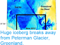
On 16 July 2012 NASA's Aqua Satellite observed an iceberg measuring 120 km² (roughly 1.5 times the area of Manhattan Island or the Isle of Sheppey) the calving away from the Petermann Glacier in northern Greenland. This is not the largest iceberg ever seen calving away from Petermann, one twice this size was produced in 2010, but it is pretty large, and is part of an ongoing trend that has seen the size of the glacier greatly diminished. 

False-colour satellite image of the new iceberg. Washington Post/University of Delaware.

The Petermann Glacier is a 70 × 15 km³ floating ice tongue connecting the Greenland Ice-sheet to the Arctic Ocean, along the Petermann Fjord. Like all glaciers it ebbs and flows over time. The 2010 calving event reduced the glacier's area by about 25%, and the 2012 event shrinks it to its smallest for 150 years.

The location of the Petermann Glacier. BBC/NASA.

The exact relationship between glacial calving and global temperatures in complicated, and glaciologists are (rightly) reluctant to relate any particular event to global warming. A glacier shrinking to its smallest for 150 years is not evidence that the climate has changed notably from 150 years ago, particularly as the growth and shrinkage of glaciers appears to be a cyclical event. However if the overwhelming majority of the worlds glaciers appear to be retreating at the same time, as is currently the case, then this is cause for alarm.

Melting ice in the Arctic is often linked to global sea-level rise, however this only applies to the melting of ice on-land, such as the Greenland Ice-sheet. The melting of floating glaciers such as Petermann has no effect on sea-levels, as the floating sea-ice displaces an equivalent amount of water to that produced when it melts.


Follow Sciency Thoughts on Facebook.