Showing posts with label Somali Plate. Show all posts

Sunday, 25 January 2026

Magnitude 5.4 Earthquake on the coast of Tanzania.

The United States Geological Survey recorded a Magnitude 5.4 Earthquake at a depth of 10 km, on the coast of Tanzania, roughly 200 km to the south of Dar es Salaam, slightly after 8.10 pm local time (slightly after 5.10 pm GMT) on Tuesday 20 January 2026. There are no reports of any damage or casualties associated with this event, although it is likely to have been felt locally.

The approximate location of the 20 January 2026 Tanzania Earthquake. USGS.

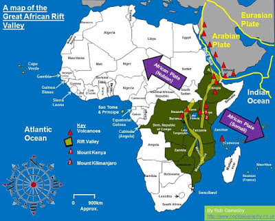
The western Tanzania lies within the the of the Great Rift Valley, which is slowly splitting the African Plate in two along a line from the Red Sea through Ethiopia, and which includes the great lakes and volcanoes of east-central Africa. This has the potential to open into a new ocean over the next few tens of millions of years, splitting Africa into two new, smaller, continents; Nubia to the west and Somalia to the east.

Movement on the African Rift Valley, with associated volcanoes. Rob Gamesby/Cool Geography.

To the southeast, the island of Madagascar has been moving away from Africa since the Jurassic, forming a series of spreading centres across the Mozambique Channel, which both continue to push the island to the east and exert pressure on the southeastern coast of Africa, contributing to Earthquake activity in the region. 

See also...

Saturday, 4 January 2025

Magnitude 5.8 Earthquake in the Afar Region of Ethiopia linked to activity on Mount Dafan.

The Ethiopian Geological Institute has reported a Magnitude 5.8 Earthquake at a depth of 10.0 km, in the Awash Fentale Woreda (District) of the Afar Region of Ethiopia, about 150 km to the northeast of Addis Ababa, slightly after 4.50 am local time (slightly after 0.50 am GMT) on Saturday 4 January 2025. There are no reports of any damage or injuries arising from this quake, but it was felt as far away as Addis Ababa, and it is possible that some minor damage has occurred.

The approximate location of the 4 January 2024 Ethiopian Earthquake. USGS.

This is the latest in a series of Earthquakes in the Central Ethiopia, which began in the third week of December 2024. Clusters of Earthquakes are concerning in northern or central Ethiopia, as the area is volcanic, and seismic movements can be linked to magma moving into chambers beneath volcanoes from deeper in the Earth, which in turn can be a predictor of future volcanic eruptions. On this occasion the Ethiopian Geological Institute has suggested that the Earthquakes may be linked to a fissure eruption on Mount Dafan, a shield volcanoe in the Dulacha Woreda, which opened on 2 January producing a sustained jet of steam and hot water. Residents of the area have been evacuated as a precaution against a future, larger eruption.

A vent which opened on Mount Dafan in the Dulacha Woreda of Ethiopia on 3 January 2024, producing a sustained jet of steam and hot water. Ethiopian Geological Institute/Facebook.

The deserts of Northern Ethiopia and Southern Eritrea are extremely volcanically active, with dozens of volcanoes fed by an emerging divergent margin along the East African Rift. The African Plate is slowly splitting apart along the Ethiopian Rift and the East African Rift to the south (which is splitting the Nubian Plate to the West from the Somali Plate to the East). Arabia was a part of Africa till about thirty million years ago, when it was split away by the opening of the Red Sea Rift (part of the same rift system), and in time the Ethiopian and East African Rifts are likely to split Africa into a number of new landmasses. This rifting exerts pressure on the rocks around the margin of the sea, slowly pushing them apart, not smoothly but in fits and starts as the pressure overcomes the tendency of the rocks to stick together, creating shocks that we experience as Earthquakes.

Rifting in East Africa. The Danakil Microplate is the red triangle to the east of the Afar depression at the southern end of the Red Sea. Università degli Studi di Firenze.

See also...

Thursday, 7 September 2023

Magnitude 5.2 Earthquake in the Singida Region of central Tanzania.

The United States Geological Survey recorded a Magnitude 5.2 Earthquake at a depth of 10 km, roughly 39 km to the southeast of the town of Ikungi in the Singida Region of northern Tanzania, slightly after 6.40 pm local time (slightly after 3.40 pm GMT) on Wednesday 6 September 2023. There are no reports of any damage or casualties associated with this event (nor would any be expected with an event of this size), but people have reported feeling it locally.

The approximate location of the 5 September 2023 Singida Earthquake. USGS.

Western Tanzania lies within the of the Great Rift Valley, which is slowly splitting the African Plate in two along a line from the Red Sea through Ethiopia, and which includes the great lakes and volcanoes of east-central Africa. This has the potential to open into a new ocean over the next few tens of millions of years, splitting Africa into two new, smaller, continents; Nubia to the west and Somalia to the east.

Movement on the African Rift Valley, with associated volcanoes. Rob Gamesby/Cool Geography.

See also...


Follow Sciency Thoughts on Facebook.

Follow Sciency Thoughts on Twitter.


Wednesday, 2 August 2023

Magnitude 5.6 Earthquake to the south of Massawa, Eritrea.

The United States Geological Survey recorded a Magnitude 5.6 Earthquake at a depth of 10.0 km, roughly 42 km to the south of the city of Massawa in central Eritrea, at about 8.15 pm local time (about 5.15 pm GMT) on Tuesday 1 August 2023. There are no reports of any damage or injuries from this quake, but people have reported feeling the event in Asmara, the capitol of Eritrea, as well as in Tigray Province, Ethiopia.

The approximate location of the 1 August 2023 Eritrea Earthquake. USGS.

The deserts of Northern Ethiopia and Eritrea are extremely volcanically active, with dozens of volcanoes fed by an emerging divergent margin along the East African Rift; the volcano Erta Ale is on the Ethiopian Rift, the boundary between the Nubian Plate and the Danakil Microplate. The African Plate is slowly splitting apart along the Ethiopian Rift and the East African Rift to the south (which is splitting the Nubian Plate to the West from the Somali Plate to the East). Arabia was a part of Africa till about thirty million years ago, when it was split away by the opening of the Red Sea Rift (part of the same rift system), and in time the Ethiopian and East African Rifts are likely to split Africa into a number of new landmasses. This rifting exerts pressure on the rocks around the margin of the sea, slowly pushing them apart, not smoothly but in fits and starts as the pressure overcomes the tendency of the rocks to stick together, creating shocks that we experience as Earthquakes.

Rifting in East Africa. The Danakil Microplate is the red triangle to the east of the Afar depression at the southern end of the Red Sea. Università degli Studi di Firenze.

See also...

Follow Sciency Thoughts on Facebook.

Follow Sciency Thoughts on Twitter.


Sunday, 11 June 2023

Magnitude 4.4 Earthquake shakes Johannesburg, South Africa

The South African Council for Geosciences recorded a Magnitude 4.4 Earthquake beneath the city of Boksburg, East Rand urban conurbation of Gauteng Province, South Africa, slightly before 2.40 am local time (slightly before 0.40 am GMT) on Sunday 11 June 2023. There are no reports of any damage or casualties associated with this event, though many people reported feeling it between Pretoria, Kimberley, and the Eswatini border.  
The approximate location of the 11 May 2023 Boksburg Earthquake. USGS.

Earthquakes of any size are relatively rare in South Africa and because of this rarity it is hard to make precise judgements about the cause of quakes in South Africa, due to a paucity of data. Northwestern South Africa is close the southern end of the Great Rift Valley exits the continent and passes out under the Indian Ocean on the coast of Mozambique. The Great Rift Valley is slowly splitting the African Plate in two allow a line from the Red Sea through Ethiopia, and which includes the great lakes and volcanoes of east-central Africa. This has the potential to open into a new ocean over the next few tens of millions of years, splitting Africa into two new, smaller, continents; Nubia to the west and Somalia to the east.

Movement on the African Rift Valley, with associated volcanoes. Rob Gamesby/Cool Geography.

Earthquakes can also sometimes be triggered by mining activity, and settling movements at old mine sites, and the location of the Boksburg mine is close to the East Rand Proprietary Mine, from which gold was excavated between its founding in 1893 and closure in 2008. A Magnitude 4.4 event would be exceptionally large for a mine-related Earthquake, but the East Rand Mine is no ordinary mine site, it was once the deepest mine in South Africa (and therefore the deepest mine in the world, the world's six deepest mines all being in South Africa). The East Rand Mine reached a depth of 3.585 km by the time it closed, a depth which has been surpassed only by four other mines; the Savuku Gold Mine in Carletonville, Gauteng Province, which reached 3.7 km in depth by the time of its closure in 2017; the TauTona Mine, also in Carletonville, which reached 3.9 km deep by the time it closed in 2018, and the Mponeng Gold Mine, in Mponeng, Gauteng Province, which is 4.0 km deep and still active.

See also...

Follow Sciency Thoughts on Facebook.

Follow Sciency Thoughts on Twitter


Monday, 20 March 2023

Possible eruption on Mount Nyamulagira, Democratic Republic of Congo.

Scientists at the Goma Volcanological Observatory have reported seeing bright lights consistent with an eruption on the summit of Mount Nyamulagira, a 3058 m high shield volcano in the Virungu Mountains of eastern Democratic Republic of Congo, about 25 km to the north of Lake Kivu. This was accompanied by seismic activity beneath the volcano, which is often indicative of magma moving into chambers prior to an eruption. Mount Nyamalugira, which lies in North Kivu Province, is often considered to be Central Africa's most active volcano, having erupted more than 40 times since 1885. Due to the highly active nature of the volcano it presents little threat to human life, because nobody chooses to live near it, though concerns have occasionally been raised about the threat it presents to wildlife in the Viruga National Park.

The approximate location of Mount Nyamulagira. Google Maps.

Mount Nyamulagira lies on the Eastern Branch of the East African Rift, which is slowly splitting the African Plate in two along a line from the Red Sea through Ethiopia, and which includes the great lakes and volcanoes of east-central Africa. This has the potential to open into a new ocean over the next few tens of millions of years, splitting Africa into two new, smaller, continents; Nubia to the west and Somalia to the east.

Movement on the African Rift Valley, with associated volcanoes. Rob Gamesby/Cool Geography.

See also...

Follow Sciency Thoughts on Facebook.

Follow Sciency Thoughts on Twitter.