Thursday, 3 April 2014

A new species of Bush Frog from central Vietnam.

Bush Frogs (Rhacophoridae) are found throughout tropical areas of Africa and Asia. They are tree-dwelling frogs that seldom venture down to the ground, their eggs being laid in a foamy construct produced by the male Frogs which is known as a phytotelm, which is typically suspended above a source of open water, the tadpoles emerging within the phytotelm and dropping into the water. Some conspicuous Tree Frogs belong within this group, including the Old World Flying Frogs.

In a paper published in the journal Zootaxa on 2 April 2014, a team of scientist led by Jodi Rowley of the Australian Museum Research Institute describe a new species of Bush Frog from Ngoc Linh Nature Reserve in Kon Tum Province in central Vietnam.

The new species is placed in the genus Gracixalus, which is found in China and Southeast Asia, and given the specific name lumarius, meaning 'of thorns', a reference to the numerous thorny tubercles on the dorsal side (back) of the Frog; Rowley et al. suggest that in English it should be referred to as the Thorny Tree Frog.

The Thorny Tree Frog, Gracixalus lumaris. Male specimen. Rowley et al. (2014).

Gracixalus lumaris is described from four adult and one juvenile specimens, as well as a cluster of eggs found with one of the specimens. The male specimens range from 38.9 mm to 41.6 mm in length, the female is 36.3 mm long, and the juvenile 25.5 mm. The frogs have a distinctive colouration, with a yellow dorsal side covered in white, thorny tubercles, mottled yellow and pink flanks and a pink underside.

The first specimen discovered was a male found in the water-filled hole in a tree, with a cluster of eggs on the tree wall above the hole. The Frogs were all found in montane Bamboo and evergreen forest, away from any obvious source of open water, such as streams or ponds, suggesting that this species has adapted to use pools within trees as a source of water in which to breed.

The tree hole in which the first specimen of Gracixalus lumaris was located, along with its phyptotelm and eggs. Rowley et al. (2014).

See also...


Follow Sciency Thoughts on Facebook.

Wednesday, 2 April 2014

Magnitude 8.2 Earthquake off the coast of northern Chile.

The United States Geological Survey recorded a Magnitude 8.2 Earthquake at a depth of 20.1 km roughly 70 km off the coast of northern Chile and 95 km to the northeast of the city of Iquique, slightly after 6.45 pm local time (slightly after 11.45 pm GMT) on Tuesday 1 April 2014. This is an extremely large and dangerous event, which the USGS estimates has a 7% chance of causing over 1000 casualties; at the time of writing 6 people are known to have died as a result of this event, and countries around the southern Pacific remain on tsunami alert.


Chilean firefighters tackle a blaze caused by the 1 April 2014 Iquique Earthquake. Aldo Solimano/Getty Images.

Chile is located on the west coast of South America, which is also the convergent margin between the Nazca and South American Plates. The Nazca Plate is being subducted beneath the South American Plate and is sinking beneath the South American Plate. This is not a smooth process, the rocks of the two plates continuously stick together then, as the pressure builds up, break apart again, causing Earthquakes. As the Nazca Plate sinks deeper it is partially melted by the friction and the heat of the Earth's interior. Some of the melted material then rises up through the overlying South American Plate as magma, fueling the volcanoes of the Chilean Andes.


The approximate location of the 1 April 2014 Iquique Earthquake. Google Maps.


The subduction of the Nazca Plate beneath the South American Plate, and how it causes Earthquakes and volcanoes. Pacific Earthquake Engineering Research Center.

Earthquakes along subductive margins are particularly prone to causing tsunamis, since these often occur when the overlying plate has stuck to the underlying plate, being pulled out of shape by its movement.. Eventually the pressure builds up tp far and the overlying plate snaps back, causing an Earthquake and a tsunami. There have been reports of waves of up to 2.5 m in height reaching the Chilean coast after the 1 April 2014 Earthquake, prompting evacuations along much of the coast of Chile and neighbouring nations.

Simplified graphic showing tsunami generation along a convergent margin. NASA/JPL/CalTech.

See also...

 Series of major Earthquakes shakes northeast Chile.

 Magnitude 4.2 Earthquake in northern Chile.

 Magnitude 5.5 Earthquake in northeast Chile.

Follow Sciency Thoughts on Facebook.

The cause of the end-Permian extinction.

The Earth has been dominated by multi-cellular life forms (animals, plants etc.) for a little over half a billion years, but life has not had it easy throughout all of this time, it has been hit by a number of mass extinction events, during each of which a large proportion of the life-forms existent went suddenly extinct. The best known of these is the extinction event at the end of the Cretaceous, which included the extinction of the non-avian dinosaurs and other large Mesozoic animals, but the biggest extinction event occurred at the end of the Permian, when roughly 96% of all marine and 70% of all terrestrial life was wiped out. The end-Permian extinction is sometimes known as the Great Extinction or the Great Dying.

The cause of the end-Permian extinction has been for several years linked to extensive volcanism in the Siberian Traps, which is thought to have led to a runaway greenhouse effect, causing rapid global warming and ocean anoxia, which in turn led to the dying out of first the majority of marine life, and then, as the carbon cycle broke down, the extinction of the majority of life on land. However the amount of carbon dioxide likely to have been released by the Siberian Traps volcanism seems unlikely to have been sufficiently high to cause global warming on the scale seen at the end of the Permian, which has led scientists to seek another source of CO₂. To this end it has been proposed that extensive coal deposits existed beneath Siberia at the time of the volcanism, and that these were destroyed in a series of raging fires, further raising atmospheric CO₂ levels. However even this model struggles to create the level of global warming seen at the end of the Permian, and furthermore is difficult to see how such fires could have burned for the lengths of time over which the warming occurred.

The extent of the Siberian Traps volcanism. MIT.

In a paper published in the Proceedings of the National Academy of Sciences of the United States of America on 31 March 2014, a team of scientists led by Daniel Rothman of the Lorenz Center and Department of Earth, Atmospheric, and Planetary Sciences at the Massachusetts Institute of Technology describe the results of a study of carbon isotope data on two rock sequences dating from the end of the Permian, and propose a new hypothesis for the extinction based upon this.

Rothman et al. studies rocks from Meishan in Sichuan Province, China and Gartnerkofel in the Carnic Alps of Austria. In both places they found that the proportion of isotopically heavy 'inorganic' carbon rose sharply compared to the proportion of isotopically light 'organic' carbon in the rocks as the end of the Permian was reached (biological organisms preferentially use isotopically light carbon, hence such carbon is often referred to as 'organic', and sudden changes in the proportion of heavy and light carbon isotopes are generally assumed to be linked to the activities of such organisms). 

The sudden release of carbon from coal deposits in Siberia would be expected to produce mainly isotopically light carbon, as this would have been used preferentially by the plants which went on to form the coal, but instead the reverse seemed to be happening; as the rocks neared the end of the Permian, the proportion of isotopically light 'organic' carbon fell, requiring a different explanation for the origin of the carbon.

Rothman et al. further note that methanogenesis in Bacteria (a process by which some bacteria can respire carbon dioxide, producing methane as a waste product, thereby surviving without free oxygen) has recently been theorized to have arisen first in Clostridia-type Bacteria in the Middle Ordovician, and spread to the widespread Archean group Methanosarcina some time since then by horizontal gene transfer (a process by which distantly related bacterial groups are able to exchange genes, sometimes known as 'bacterial sex', but in many ways more akin to trade).

A colony of Methanosarcina-type Archeans. Daily Tech/KRLE

Rothman et al. carried out a phylogenetic analysis of Methanosarcina-type Archeans, from which they derived a molecular clock which suggested the group had undergone a major evolutionary radiation at the end of the Permian. They therefore suggest that this would have been the time at which they acquired the methanogenic genes.

In order to carry out methanogenesis, micro-organisms need a supply of nickel, which is used as a catalyst in the reaction. The rocks from Meishan show a spike in nickel levels towards the end of the Permian, which Rothman et al. suggest may have derived from the Siberian Traps volcanism.

They therefore theorize that towards the end of the Permian the Methanosarcina-type Archeans, acquired the genes for metabolizing carbon dioxide into methane, a far more powerful greenhouse gas. At the same time the Siberian Traps volcanism was supplying a ready supply of both carbon dioxide and nickel, allowing the group to undergo a major expansion. This led to a dramatic increase in the amount of methane in the atmosphere, leading to the runaway greenhouse effect that caused the mass extinction. Like all organisms, the Methanosarcina-type Archeans preferentially used isotopically lighter 'organic' carbon in their biological processes, leading to a reduction in the proportion of isotopically light CO₂ in the atmosphere, and therefore (eventually) the rock record (limestone is formed from a carbon dioxide dissolved in the sea, but not from methane).

See also...


Follow Sciency Thoughts on Facebook.

Asteroid 2009 FD passes the Earth.

Asteroid 2009 FD passed the Earth at a distance of roughly 15 100 000 km (a little over 39 times the average distance between the Earth and the Moon) at about 9.10 am GMT on Tuesday 1 April 2014. There was no danger of the asteroid hitting us, though were it to do so it would be likely to cause severe problems. 2009 FD is calculated to be 472 m in diameter, and an object of this size would be expected to punch straight through the Earth's atmosphere, impacting directly into the ground, an impact which would result in an explosion over 17 650 times as large as that caused by the Hiroshima bomb, creating a crater over 7 km in diameter and climatic effects that could last for decades.

Image of 2009 FD captured by the Very Large Telescope on 1 January 2014. The elongate structures are actually stationary stars, they appear drawn out as the telescope was tracking the asteroid during a shot with a long exposure time. European Southern Observatory.

2009 FD was discovered by the Observatorio AstronĂ³mico de La Sagra in southern Spain on 16 March 2009. The designation 2009 FD implies that it was the fourth object (object D) discovered in the second half of March 2009 (period 2009 F).

2009 FD has an 1.25 year orbital period and an eccentric orbit that takes it from 0.59 AU from the Sun (i.e. 59% of the average distance at which the Earth orbits the Sun, inside the orbit of Venus) to 1.75 AU from the Sun (i.e. 127% of the average distance at which the Earth orbits the Sun, outside the orbit of Mars). It is therefore classed as an Apollo Group Asteroid (an asteroid that is on average further from the Sun than the Earth, but which does get closer).

The calculated orbit of 2009 FD. JPL Small Body Database Browser.

This short orbital period and Earth-crossing orbital path means that 2009 FD makes frequent close passes of the Earth, the most recent having occurred on 24 October 2010, and the next being predicted for 29 October 2015. It also makes frequent close approaches to the planets Venus and Mars, the most recent of which occurred on 3 August 2013, when 2009 FD came within 11 600 000 km of Mars, and the next is predicted to happen on 6 May 2017, when 2009 FD will come within 10 810 000 km of Mars. These close encounters with planets raise the possibility of 2009 FD being nudged onto a slightly different course by tidal energy, making its long-term danger to the Earth harder to predict.

The large size and frequent close proximity to Earth of 2009 FD have made it a subject of considerable interest to astronomers, with its future trajectory being calculated for several centuries ahead, calculations that have been updated several times following detailed observations of the asteroid. In January 2011 it was estimated by JPL that there was a 1 in 435 chance of 2009 FD impacting the Earth in 2185, though this possibility has now been ruled out. There is currently considered to be a 1 in 667 change that 2009 will impact the Earth on 30 March 2190.

See also...


Follow Sciency Thoughts on Facebook.

Eruption on Mount Karymsky produces 2.1 km ash column.

Mount Karymsky, a stratovolcano (cone-shaped volcano) on the Kamchatka Peninsula considered to be Russia's most active volcano, underwent a series of eruptions on Monday 31 March 2014, the largest of which produced a 2.1 km high ash column that drifted 50 km to the southeast, according to the Kamchatka Volcanic Eruption Response Team, which has issued a warning to aviation. The volcano has undergone a series of eruptions since the beginning of March, having been relatively quiet throughout February. It's previous eruptive cycle lasted from December 2013 into January this year. Despite frequent major eruptions Karymsky presents little threat to human life, due to its remote location on the sparsely populated Kamchatka Peninsula.

Archive photograph of a small eruption on Mount Karymsky. Alexander Belousov.

The Kamchatka Peninsula lies on the eastern edge of the Okhotsk Plate, close to its margin with the Pacific and North American Plates. The Pacific Plate is being subducted along the margin, and as it does so it passes under the southern part of the Kamchatka Peninsula, and as it does so is partially melted by the friction and the heat of the Earth's interior. Some of the melted material then rises through the overlying Okhotsk Plate as magma and fueling the volcanoes of southern Kamchatka.

The approximate location of Mount Karymsky. Google Maps.

See also...


Follow Sciency Thoughts on Facebook.

Tuesday, 1 April 2014

Novel burrows from the Miocene of Mizoram State, northeast India.

The fossil record comprises not just the physical remains of organisms that have lived and died in past eras of the Earth's history, but also numerous traces left by these organisms. The study of these traces, ichnology, can reveal important data about past ecosystems even where the identity of the trace maker is unknown, as different organisms will often produce similar burrows in response to similar environmental challenges.

In a paper published in the journal PLoS One on 18 October 2013, Raghavendra Tiwari and Chinmoy Rajkonwar of the Department of Geology at Mizoram University and Satish Patel of the Department of Geology at the Maharaja Sayajirao University of Baroda describe a series of novel burrows from the earl-middle Miocene Bhuban Formation at Aizawl in Mizoram State in northeastern India.

The burrows are placed in the ichnogenus Funalichnus (trace fossils are often named in the same way as body fossils, although these names reflect only similarity of form, not an implied relationship between the trace-makers), which has previously been used to name similar burrows from the Late Cretaceous of the Bohemian Basin in the Czech Republic, and given the specific name bhubani, which is derived from the formation in which it was found.

Funalichnus bhubani is a vertical or nearly vertical burrow, straight, unbranching and smooth with an oval profile, split into a number of cylindrical segments oblique to the long axis. The lower part of the burrow tapers rather than stopping abruptly. The burrows are considerably larger than similar burrows previously seen in the Bohemian Basin (and named Funalichnus strangulatus) reaching 120-200 mm in length and 10-36 mm in diameter, whereas the largest Bohemian trace was only 51 mm in length.

Funalichnus bhubani  specimens from the from the Bhuban Formation at Aizawl in Mizoram State. Tiwari et al. (2013).

The burrows were found in a grey, fine-to-medium grained sandstone which was heavily bioturbated with numerous other, better studied, burrows, as well as ripple marks, cross bedding and other sedimentary structures. This is interpreted as having a shifting, unconsolidated sandbed near to a shore.

See also...


Follow Sciency Thoughts on Facebook.

Eruption on Mount Urbinas.

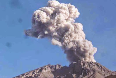
Mount Urbinas, a small but highly active volcano in the southern Peruvian Andes, generally considered to be Peru's most active volcano, erupted at 7.42 am local time (1.42 pm GMT) on Monday 31 March 2014, according to the Geophysical Institute of Arequipa, producing an ash column rising 1000 m above the volcano's summit, and leading to the evacuation of the village of Querapi, which is 5 km from Urbinas. The volcano began to show signs of activity in September 2013, after several years of inactivity, but this is the first major eruption since then.

The ash column above Urbinas as seen at 7.44 am local time on 31 March 2014. Observatorio vulcanolĂ³gico del Ingemmet.

The volcanoes of the Peruvian Andes, and of South America in general, are fueled by the subduction of the Nazca Plate beneath the South American Plate. The Nazca Plate underlies a large chunk of the eastern Pacific Ocean, and is being subducted along Peru-Chile Trench to the west of South America. As it sinks into the Earth, the Nazca Plate passes under South America, where it is heated by friction with the overlying South American Plate and by the heat of the planet's interior. This causes the Nazca Plate to partially melt, and some of this melted material then rises through the South American Plate as magma, fueling the volcanoes of the Andes. The motion of one plate beneath another is not a smooth process, and the Nazca and South American Plates frequently stick together, then break apart as the pressure builds up, triggering frequent Earthquakes along the western coast of South America, and sometimes further inland.

The approximate location of Mount Urbinas. Google Maps.

See also


Follow Sciency Thoughts on Facebook.