Thursday, 15 November 2012

Building an artificial Coral Reef on Pulau Weh, Indonesia.

Coral reefs are important marine ecosystems and vital economic resources to coastal communities across the tropics. However Corals in almost all areas have been dying back, due to pollution, rising sea temperatures, increased tropical cyclones and invasive species, such as the Crown of Thorns Starfish. This has led to a number of attempts to recreate reefs in areas where they have died back, however most of these have been expensive and have failed to involve and gain the support of local people, due to a reliance on imported technology and expertise, and most have not succeeded in the long term, either due to a failure to address the problems that caused the original reef die-back, or due to larger-scale climatic or environmental problems that were hard to predict.

In a paper published in the journal Oryx on 4 October 2012, a team of scientists led by Nur Fadli of the Centre for Marine and Fisheries Studies at Syiah Kuala University describe the results of an attempt to artificially re-create a Coral Reef by local communities on Pulau Weh, an island off the northern tip of Sumatra in Indonesia.

The location of the artificial reef on Pulau Weh. Fadli et al. (2012).

The project was run by local resident Pak Dodent and members of staff of Rubiah Tirta Divers, using grants from funds to help rebuild local communities after the 2004 tsunami, which had devastated the original reef. The artificial reef comprised 2690 concrete modules, each 1.25 m², each made up of nine round blocks with sloping sides and a section of plastic piping at the top. These were surrounded by four oblong blocks, also with sloping sides, and each with four sections of plastic tubing on top. Each of these modules took 40 person/hours to install, at a total cost of IDR 440 000 (US$45). The project provided three months employment for three people. 

Diagram of a single reef module. Fadli et al. (2012).


Fragments of Coral were attached to the upright pipes, and the blocks were scrubbed to prevent competition from other organisms. Periodic maintenance was also carried out, righting overturned blocks, re-attaching or replacing Coral fragments that had become detached etc.

Individual block with attached Coral. Fadli et al. (2012).

Average Coral cover on the artificial reef blocks was 24% in the first year, rising to 64% in the third year. The modules were quickly colonized by additional species of Coral, including some classed as Near Threatened and Vulnerable on the IUCN Red List. The artificial reefs also succeeded in attracting Fish, with 29 species recorded across 250 m² of artificial reef, including some pelagic predators. 

In addition the project was successful in attracting tourists, both local and international, and received considerable support from the local community, suggesting that it was perceived as beneficial.

Top, a new reef module. Middle, a three-year-old module with a diverse range of corals. Bottom, reef fish around an artificial reef module. Fadli et al. (2012).

Unfortunately in the third year of the project the area suffered a sharp rise in sea temperatures, leading to a Coral bleaching event (an event in which the Corals respond to environmental stress by rejecting their symbiotic algae), which killed almost all of the Corals on both the artificial reefs and nearby natural reefs.

However the project did demonstrate that community-lead reef restoration schemes such as this have genuine potential. The 2004 tsunami lead to a large amount of funds becoming available in the region for community projects, but did not damage reefs in many places, so this project was fairly unique. Fadli et al. note that in excess of US$200 million has been spent on various artificial reef projects around the world, which has resulted in less than 1 km² of new reef being created. The Pulau Weh project cost a total of US$8500, and created 325 m² of new reef, whilst creating jobs for local people, and without the need for expensive outside technology or expertise. This suggests that similar projects have the potential to be more successful than traditional approaches to reef rebuilding, and that such projects should form a key part of future reef management and restoration. 


Follow Sciency Thoughts on Facebook.

Wednesday, 14 November 2012

A new Ceratosaurian Theropod from the Early Cretaceous of Spain.

The Ceratosaurians were a diverse group of Theropod Dinosaurs abundant in the Mid-to-Late Jurassic and the Late Cretaceous, but uncommon in intervening period. This suggests that they either underwent to periods of ecological success, with an interval between in which they were marginalized, or that they were successful throughout the Cretaceous but that their fossils have not been discovered. They are better known from the southern hemisphere, but not absent from the north.

In a paper published in the journal Acta Palaeontologica Polonica on 23 October 2012, Bárbara Sánchez-Hernández and Mike Benton of the School of Earth Sciences at the University of Bristol describe a new species of Ceratosaurian from the Early Cretaceous of central Spain. The skeleton is partial and fragmentary, having been exposed during the ploughing of a field.

The new Dinosaur is named Camarillasaurus cirugedae, meaning Cirugeda's Camarillas-reptile; it was found by farmer Pedro Cirugeda Buj on his farm at Camarillas. The specimen comprises a partial tooth, some ribs, several vertebrae, part of the hip and leg-bones.

The tooth of Camarillasaurus cirugedae. Shown in (A) labial-lateral view, (B) lateral view, and (C) Cross sectional view, with (D, E, F) shading to show broken areas (grey) and wear facets (white). Sánchez-Hernández & Benton (2012).

Cervical (neck) vertebrae in (A) right lateral, (B) posterior?, (C) anterior? and (D) ventral views.  Scale bar is 5 mm. Sánchez-Hernández & Benton (2012).

Presacral (lower back) vertebrae in (A) anterior, (B) left lateral and (C) posterior views. Possible neural spine tips in (D) posterior? and (E) transverse? views. (F) Rib. (G) Detail of proximal end of rib. Scale bars are 10 mm (A, B, C, G), 20 mm (D, E) and 100 mm (F). Sánchez-Hernández & Benton (2012).

Dorsal vertebrae.  Sánchez-Hernández & Benton (2012).

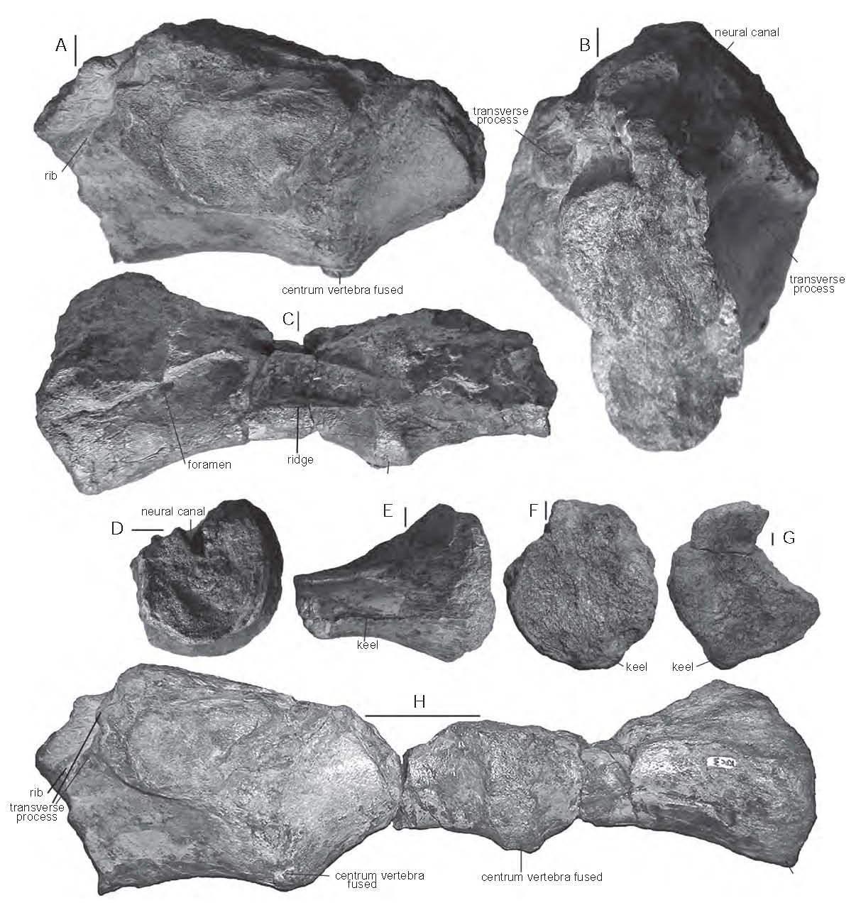
Sacrum (part of hip joint) in (A) left lateral and (B) anterior views. Fused centra (also part of hip joint) in (C) right lateral and (D) anterior views. Incomplete centrum in (E) lateral and (F) anterior? views. (G) Incomplete centrum in ventral view. (H) Sacrum and fused centra in  lateral view. Scale bars are 10 mm, except (H) which is 40 mm. Sánchez-Hernández & Benton (2012).

Caudal vertebrae. Sánchez-Hernández & Benton (2012).

Haemal arches (muscle supporting processes on the underside of the tail vertebrae). Sánchez-Hernández & Benton (2012).

Fragmentary scapulocoracoid (part of the hip joint) in medial (A & B), posterior (C) and anterior (D) views. arrow points to ridges that might indicate a muscle insertion, or tooth marks. Scale bars are 10 mm. Sánchez-Hernández & Benton (2012).

Top: Right sternal plate (part of the rib cage) in (A) lateral and (B) ventral view. Bottom: Left sternal plate in (C) lateral and (D) ventral views. Scale bars are 10 mm. Sánchez-Hernández & Benton (2012).

Proximal portion of the right tibia in (A) lateral, (B) medial, (C) anterior, (D) posterior, (E) proximal and (F) distal views. (G) Detail of the tibial foramen area, in lateral view. Scale bars are 10 mm. Sánchez-Hernández & Benton (2012).

See also A new Therizinosauroid Dinosaur from the Early Cretaceous of UtahNew species of Dromaeosaur from the Early Cretaceous of UtahPolice seize Dinosaur from New York warehouseKelmayisaurus petrolicus reconsidered and Dinosaurs on Sciency thoughts YouTube.

Follow Sciency Thoughts on Facebook.

Sunday, 11 November 2012

Northern Myanmar shaken by series of Earthquakes.

On Sunday 11 November 2012, slightly after 7.40 am local time (slightly after 1.10 am, GMT) the United States Geological Survey recorded a Magnitude 6.8 Earthquake at a depth of 9.8 km in northern Myanmar (Burma), 117 km north of Mandalay. This is a very large Earthquake at a shallow depth in a rapidly industrializing area of an underdeveloped nation, an extremely dangerous combination of factors; the United States Geological Survey estimate that a quake on this scale in this area would have a 97% chance of leading to fatalities. Were this not bad enough, the quake have been followed, at the time of writing (8.00 pm, GMT), by at least 4 further quakes in excess of Magnitude 5, which would normally be considered serious events in themselves.

Map showing the distribution of quakes in Myanmar on 11 November 2012. The largest square represents the initial, and biggest, quake, the red square the most recent. The red line is the margin between the Indian Plate (to the west) and the Eurasian Plate (to the East). USGS.

The extent of damage on the ground is not yet clear, but there appear to have been a considerable number of casualties. Several ancient monuments, including at least one monastery, are said to have collapsed, as is a bridge being constructed over the River Irrawaddy, and several mines (the area produces gold and precious minerals). It is unclear if the extent of the damage will be revealed by the government of Myanmar once it is known; the country has a history of extreme secretiveness, and while it claims to be in a process of reforming after years of military dictatorship, many journalists trying to contact the country after todays events report government officials would only talk to them on condition of anonymity.

The remains of a bridge being constructed over the Irrawaddy near Shwebo, which collapsed as a result of the 11 November 2012 Earthquakes. It is thought that at least two workers on the bridge were killed by the collapse. Associated Press.

Badly damaged pagoda at Ma La. Reuters.

Northern Myanmar is an area fairly prone to Earthquakes. It lies close to the margin between the Indian and Eurasian Plates, and suffers tectonic stresses due to the northward movement of the Indian Plate, which is driving into the Eurasian Plate at a rate of about 30 mm per year, causing uplift in the Himalayan Mountains, the Tibetan Plateaux, the mountains of Central Asia, and the bordering hills that separate Myanmar from India and China.


Follow Sciency Thoughts on Facebook.

Iceberg damage in an Antarctic Clam.

The large Clam Laternula elliptica is found in coastal waters across the Southern Ocean, around the tip of Patagonia and all around the coast of Antarctica. It is considered a keystone species in Antarctic ecosystems, forming an appreciable percentage of the total biomass. It lives infaunally, buried in mud at depths of up to 50 cm, and filtering food from the water column. It faces few predators due to an absence Antarctic animals capable of digging it out, though it is known to be targeted by a type of Fish, Trematomus hansoni, which bites off its siphons.

In a paper published in the journal PLoS One on 28 September 2012, a team of scientists led by Elizabeth Harper of the Department of Earth Sciences at the University of Cambridge discuss the results of a study into damage to the shells of Laternula elliptica, which suggests that iceberg scour is a major source of damage to these animals.

The team sampled Clams from seven sites around Antarctica, and analyzed the shells of living animals for damage and repair, looking for signs of predation or chemical dissolution as well as physical damage. All of the Clams were sampled at depths to great for them to be damaged by storm or tidal turbation.

Map showing the locations from which the Clams were excavated. Harper et al. (2012).

Harper et al. found shells showing signs of recovery from severe crushing at all sites, despite the fact that the Antarctic lacks any known predator which attacks Clams in this way, and the Clams being recovered from sites not targeted by trawl-fishers. The incidence of damaged Clams varied greatly with from 1.7% to 74.2% of the Clams showing signs of having been crushed at different sites.

Typical undamaged Laturnula elliptica shells. Scale bar is 10 mm. Harper et al. (2012).

Laturnula elliptica shells showing signs of damage and repair. Scale bars are 10 mm. Harper et al. (2012).

The damage was most frequent at sited where scouring of the seafloor by icebergs was common, and rarest where permanent pack ice makes scouring by free-floating icebergs unlikely. Clams have been observed being excavated by such scouring and being forced to rebury themselves, suggesting that this scouring was the source of the damage. Harper et al. also noted that Clams in shallower water have thicker shells than those in deeper water, and while the genetics of the Clams is not understood, suggest this is most likely to be as a result of the Clams reacting to their environment by secreting more or less shell, rather than strains of Clams with different shell-thicknesses and depth-preferences being present at numerous sites around Antarctica.

See also The evolution of Galeommatoid BivalvesSymbiosis and the success of Galeommatoid Bivalves, The biology of pumice raftsA new species of Scallop from Western Australia and Marine Invertebrates on Sciency Thoughts YouTube.

Follow Sciency Thoughts on Facebook.

Earthquake in eastern Kentucky.

On Saturday 10 November 2012, slightly before 12.10 pm local time (slightly before 5.10 pm, GMT), the United States Geological Survey recorded a Magnitude 4.3 Earthquake 19.9 km beneath eastern Kentucky. This is not a particularly large quake, and is in a fairly sparsely populated area, but the United States Geological Survey estimate there is a 24% chance of a quake of this size in this area causing at least one fatality. This quake does not appear to have caused any damage or casualties, but it was felt up to 240 km away by residents of seven states. 

Location of the 10 November 2012 quake. Google Maps.

The American Midwest is not an area generally associated with Earthquakes, but has in fact suffered some of North Americas largest and most destructive events. This is due to the New Madrid Fault Zone, and ancient area of tectonic activity dating back to the breakup of the Rodinian Supercontinent in the Neoproterozoic, about 750 million years ago. The area is underlain by the Reelfoot Rift, a potential ocean that started to open during the Rodinian breakup but never developed. The rocks of the fault zone were drawn apart over an area that runs from Illinois to Mississippi, and suffered a number of volcanic intrusions. 750 million years later these structures are deeply buried by more modern sediments, but are also prone to movement again. North America is being squeezed by the expansion of the Atlantic Ocean to the east and the subduction of parts of the ancient Farallon Plate to the west. This necessitates some movement within the continent to relieve the stress, and the New Madrid Fault Zone provides an area of pre-existing weakness where this can happen.

The ancient rift structure beneath the New Madrid Fault Zone. Geological Survey of Alabama.


Follow Sciency Thoughts on Facebook.

Saturday, 10 November 2012

A fossil Cricket in Miocene amber.

The Dominican Republic hosts three sites noted for the production of exceptionally clear amber with numerous preserved Insects, together regarded as a fossil Lagarstätte. The amber is thought to be the preserved resin of an extinct tropical tree, Hymenaea protera, a type of Legume. The sites are Oligocene to Miocene in age, on average about 25 million years old.

In a paper published in the journal ZooKeys on 22 October 2012, Sam Heads of the Illinois Natural History Survey and the Department of Entomology at the University of Illinois at Urbana-ChampaignDavid Penney of the Faculty of Life Sciences at the University of Manchester and David Green of the Department of Geology at the Amgueddfa CymruNational Museum Wales describe a new species of Cricket from Early Miocene amber from the Dominican Republic.

The new Cricket is placed in the genus Proanaxipha, which has previously been used to describe two other species of Cricket from Miocene Dominican amber (though Heads et al. regard one of these as somewhat unreliable), and is given the specific name madgesuttonae in honour of Madge Sutton. It is a 5.97 mm male Insect, differing from previously described Crickets of the genus Proanaxipha in the fine structure of its wings.

Proanaxipha madgesuttonae in (1) dorsal and (2) ventral views. Heads et al. (2012).


Follow Sciency Thoughts on Facebook.

A new species of Mayfly from western Ecuador.

Mayflies are an ancient group of insects related to the Dragonflies and Damselflies. They have a long aquatic larval stage followed by a short flying adult phase, which typically does not feed, simply emerging from the water, mating, and laying eggs at a new site. This adult form, called the imago may survive from a few hour to a few days, depending on the species.

In a paper published in the journal Zootaxa on 11 September 2012, Wills Flowers of the Estación Experimental Tropical Pichilingue at the Instituto Nacional Autónimo de Investigaciones de Agropecuaria describes a new species of Mayfly from the coastal mountains of western Equador.

The new species is placed in the genus Atopophlebia, and given the specific name pitculya, after a mythical being in the mythology of the Cayapas people of northwestern Ecuador, that is believed to live in rivers and streams and paint its body with yellow dye; the insects are yellowish in colour.


Atopophlebia pitculya, adult male. Flowers (2012).

The nymphs (immature insects were found living in ephemeral pools and streams and in damp leaf-litter in places where their pools were seasonal. Adults used in the description of the species were artificially raised from these nymphs. The adult male flies average 5.8 mm in length and the females 11.6 mm. Both are yellowish tan in colour. The male nymph is considerably larger than the adult, comparable with the female in size.

Map showing the known distribution of Atopophlebia pitculya (solid stars) and related species; A. fortunensis (open stars), A. obrienorum (solid circle), A. yarinacocha (solid square) and A. flowersi (open circles). None of these spcies is found on both sides of the Andes, suggesting that original continuous populations were divided by the Andean Orogeny (formation of the Andes Mountains) and have subsequently evolved into new species. Flowers (2012).

Pool inhabited by nymphs. Manabí Provinced, Ecuador. Flowers (2012).


 Follow Sciency Thoughts on Facebook.