
Natural Resources Canada recorded
a series of three Earthquakes at a depth of 10 km about 200 km off the west coast of British Columbia on 21/22 October 2018, with the first occurring slightly before 10.40 pm local time on Sunday 21 October (slightly before 5.40 am on Monday 22 October GMT), and having a Magnitude of 6.5 , the second occurring slightly after 11.15 pm local time (slightly after 6.15 am GMT), and having a Magnitude of 6.8, and the third occurring slightly after 11.20 pm local time (slightly after 6.20 am GMT) and having a Magnitude of 6.5. These events were felt along much of the coast of British Columbia and Washington State, but there are no reports of any damage or casualties.

The approximate location of the 21/22 October 2018 British Columbia Earthquakes. USGS.
Vancouver
Island is located on the western margin of the North American Plate,
close to the Challenger Trench, along which the Explorer and Juan de
Fuca Plate are being subducted. These are two remnant parts of the
ancient Farallon Plate, which formerly underlay part of the eastern
Pacific, and which has now been largely subducted beneath North America.
The Explorer an Juan de Fuca Plates pass under the North American Plate
as they sink into the Earth, but this is not a smooth process, with the
plates constantly sticking together then breaking apart as the tectonic
stresses build up.
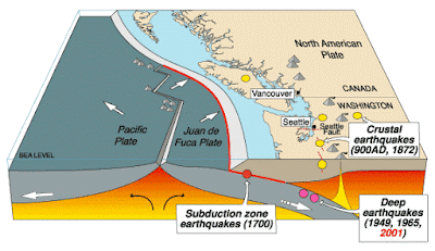
The subduction of the Juan de Fuca Plate beneath North America. United States Geological Survey.
On this occasion the Earthquake occurred on the northern part of the Juan de Fuca Plate, close to the Juan de Fuca Ridge. The
Juan de Fuca ridge marks the extensional margin between the Juan de
Fuca Plate and the Pacific Plate. The Juan de Fuca Plate is thought to
be a remnant of an ancient plate known as the Farallon Plate, a once
vast plate now largely subducted beneath the North American Plate. There
are three remnants of this plate remaining off the west coast of the
US; the Juan de Fuca Plate, the Gorda Plate to the south and the
Explorer Plate to the north. The Juan de Fuca Ridge was once part of the
longer Farallon Ridge, which ran along the eastern margin of the
Farallon Ridge before it was fractured into three parts.
Spreading on the Juan de Fuca Ridge, and its relationship to the volcanoes of the North American west coast. Wikimedia Commons.
Witness reports can help geologists to understand the processes going on
in Earthquakes and the structures in the rocks that cause them. If you
felt any of these quakes you can report it to Natural Resources Canada here.
See also...


Follow Sciency Thoughts on Facebook.