Sunday, 26 November 2017

Xylocopa sarawatica: A new species of Large Carpenter Bee from Saudi Arabia.

Large Carpenter Bees, Xylocopa spp., are large Bees resembling Bumble Bees, Bombini, though they can generally be told apart by inspection of the abdomen, which tends to be glossier and less furry in Large Carpenter Bees. The name Carpenter Bee (which they share with Small Carpenter Bees, ceratina spp.)  Comes from their habit of building nests in tough plant material, such as dead wood or Bamboo, though there are some ground nesting species. Most Large Carpenter Bees are solitary, though some species have a simple form of sociality, with females remaining in the nests of their mothers and sharing resources. Two different mating patterns are found within this group, with some species having large-headed, large-eyed males that actively hunt females to mate with, while others have small-headed males which release pheromones to attract females.

In a paper published in the journal ZooKeys on 23 November 2017, Michael Engel of the Division of Entomology at the Natural History Museum of the University of Kansas, the Department of Ecology & Evolutionary Biology, also at the University of Kansas, and the Division of Invertebrate Zoology at the American Museum of Natural History, Abdulaziz Alqarni of the Department of Plant Protection at King Saud University, Mohamed Shebl, also of the Department of Plant Protection at King Saud University, and the Department of Plant Protection at the Suez Canal University, Javaid Iqbal, again of the Department of Plant Protection at King Saud University, and of the Department of Entomology at the Muhammad Nawaz Shareef University of Agriculture, and Ismael Hinojosa-Díaz, of the Departamento de Zoología at the Universidad Nacional Autónoma de México, describe a new species of Large Carpenter Bee from the Sarawat Mountains of southwest Saudi Arabia.

The new species is named Xylocopa sarawatica, where 'sarawatica' in reference to the Sarawat Mountains, where it was discovered. Females of this species reach 14.8-17.0 mm in length, with the only male measured being 14.9 mm long. Both sexes are black or dark brown and covered in fur, which is again black over much of the body, though the fur on the upper part of the thorax is yellow.

Xylocopa sarawatica, female specimen. Engel et al. (2017).

See also...

http://sciencythoughts.blogspot.co.uk/2017/10/bombus-trophonius-new-species-of-bumble.htmlhttp://sciencythoughts.blogspot.co.uk/2017/01/endothermy-in-ivory-palms.html
http://sciencythoughts.blogspot.co.uk/2016/10/ceropegia-sandersonii-flower-mimicking.htmlhttp://sciencythoughts.blogspot.co.uk/2016/10/fossil-bees-nests-from-taung-child.html
http://sciencythoughts.blogspot.co.uk/2016/01/townsendiella-ensifera-new-species-of.htmlhttp://sciencythoughts.blogspot.co.uk/2014/07/nest-cells-of-leafcutter-bees-from.html
Follow Sciency Thoughts on Facebook.

Saturday, 25 November 2017

Family of eleven made homeless by landslide in Sarawak, Malaysian Borneo.

A family of eleven has been made homeless following a landslide which destroyed their home on Thursday 23 November 2017. The incident happened slightly after 2.15 am local time, at Jalan Melekun in the Kapit Division, and also damaged three other properties, though fortunately nobody was hurt as the family were away at the time. The incident is reported to have happened after heavy rainfall in the area.

The scene of the 23 November 2017 Kapit landslide. The Star.

The incident is reported to have happened after heavy rainfall in the area. Landslides are a common problem after severe weather events, as excess pore water pressure can overcome cohesion in soil and sediments, allowing them to flow like liquids. Malaysia has become increasingly landslip-prone in recent years due to extensive deforestation, which leaves soil exposed to heavy tropical rainfall. Concerns have also been raised about the large number of construction sites on steep hillslopes in urban areas, where workers are particularly vulnerable to landslip events during the Monsoon Seasons.

The approximate location of the 23 November 2017 Kapit landslide. Google Maps.

Sarawak has two distinct Monsoon Seasons, with a Northeast Monsoon driven by winds from  the South China Sea that lasts from November to February and a Southwest Monsoon driven by winds from the southern Indian Ocean from March to October. Such a double Monsoon Season is common close to the equator, where the Sun is highest overhead around the equinoxes and lowest on the horizons around the solstices, making the solstices the coolest part of the year and the equinoxes the hottest.
 
 The winds that drive the Northeast and Southwest Monsoons in Southeast Asia. Mynewshub.
 
Monsoons are tropical sea breezes triggered by heating of the land during the warmer part of the year (summer). Both the land and sea are warmed by the Sun, but the land has a lower ability to absorb heat, radiating it back so that the air above landmasses becomes significantly warmer than that over the sea, causing the air above the land to rise and drawing in water from over the sea; since this has also been warmed it carries a high evaporated water content, and brings with it heavy rainfall. In the tropical dry season the situation is reversed, as the air over the land cools more rapidly with the seasons, leading to warmer air over the sea, and thus breezes moving from the shore to the sea (where air is rising more rapidly) and a drying of the climate.
 
  Diagrammatic representation of wind and rainfall patterns in a tropical monsoon climate. Geosciences/University of Arizona.
 
See also...

http://sciencythoughts.blogspot.co.uk/2015/12/magnitude-60-earthquake-on-coast-of.htmlhttp://sciencythoughts.blogspot.co.uk/2015/06/casualties-confirmed-following.html
http://sciencythoughts.blogspot.co.uk/2014/08/mapping-deforestation-on-borneo.htmlhttp://sciencythoughts.blogspot.co.uk/2014/06/investigation-underway-after-natural.html
http://sciencythoughts.blogspot.co.uk/2014/06/two-killed-by-landslide-in-sabah-state.htmlhttp://sciencythoughts.blogspot.co.uk/2013/09/family-has-close-escape-as-landslide.html
Follow Sciency Thoughts on Facebook.

Asteroid 2017 VC14 passes the Earth.

Asteroid 2017 VC14 passed by the Earth at a distance of about 483 000 km (1.25 times the average distance between the Earth and the Moon,  or 0.32% of the distance between the Earth and the Sun), at about 1.45 am GMT on Saturday 18 November 2017. There was no danger of the asteroid hitting us, though were it to do so it would not have presented a significant threat. 2017 VC14 has an estimated equivalent diameter of 3-12 m (i.e. it is estimated that a spherical object with the same volume would be 3-12 m in diameter), and an object of this size would be expected to explode in an airburst (an explosion caused by superheating from friction with the Earth's atmosphere, which is greater than that caused by simply falling, due to the orbital momentum of the asteroid) in the atmosphere more than 28 km above the ground, with only fragmentary material reaching the Earth's surface.

The calculated orbit of 2017 VC14. Minor Planet Center.

2017 VC14 was discovered on 15 November 2017 (three days before its closest approach to the Earth) by the University of Arizona's Mt. Lemmon Survey at the Steward Observatory on Mount Lemmon in the Catalina Mountains north of Tucson. The designation 2017 VC14 implies that the asteroid was the 353rd object (object C14) discovered in the first half of November 2017 (period 2017 V). 

2017 VC14 has a 1104 day orbital period and an eccentric orbit tilted at an angle of 2.50° to the plane of the Solar System, which takes it from 0.89 AU from the Sun (i.e. 89% of he average distance at which the Earth orbits the Sun) to 3.28 AU from the Sun (i.e. 328% of the average distance at which the Earth orbits the Sun, more than twice the distance at which the planet Mars orbits). It is therefore classed as an Apollo Group Asteroid (an asteroid that is on average further from the Sun than the Earth, but which does get closer). This means that 2017 VC14 has occasional close encounters with the Earth, which it last came close to in November 2014, and is next predicted to pass in October 2020.

See also...

http://sciencythoughts.blogspot.co.uk/2017/11/fireball-over-saitama-prefecture-japan.htmlhttp://sciencythoughts.blogspot.co.uk/2017/11/asteroid-2017-vn13-passes-earth.html
http://sciencythoughts.blogspot.co.uk/2017/11/asteroid-2017-vv12-passes-earth.htmlhttp://sciencythoughts.blogspot.co.uk/2017/11/asteroid-2017-vf14-passes-earth.html
http://sciencythoughts.blogspot.co.uk/2017/11/asteroid-2017-wd-passes-earth.htmlhttp://sciencythoughts.blogspot.co.uk/2017/11/the-leonid-meteors.html
Follow Sciency Thoughts on Facebook.

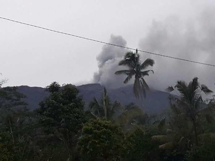
Flights to and from Bali cancelled following eruption on Mount Agung.

Several airlines have cancelled all flights to and from the island of Bali following an eruption on Mount Agung, a volcano on the eastern part of the island, on Tuesday 21 November 2017, which produced an ash column that rose 1.5 km above the 3 km summit of the mountain. Volcanic ash is extremely hazardous to aircraft in a number of ways. At its most obvious it is opaque, both visually and to radar. Then it is abrasive, ash particles physically scour aircraft, damaging components and frosting windows. However the ash is most dangerous when it is sucked into jet engines, here the high temperatures can melt the tiny silica particles, forming volcanic glass which then clogs engine. When this happens the only hope the aircraft has is to dive sharply, in the hope that cold air passing through the engine during the descent will cause the glass to shatter, allowing the engine to be restarted. Obviously this is a procedure that pilots try to avoid having to perform.

 An ash column over Mount Agung, Bali, earlier this week. Baliberkarya.

Mount Agung became active in September this year, for the first time in over fifty years. This activity has caused considerable concern on the island, as when it last erupted in  1963-4, when it produced ash columns reaching 10 km above its 3 km high summit and lava flows that reached 7 km from the volcano, as well as triggering a series of lahars and pyroclastic flows that killed over 200 people, making people on the island very cautious about any future eruptions.

The approximate location of Mount Agung. Google Maps.

The Indo-Australian Plate, which underlies the Indian Ocean to the south of Java, Bali and Lombok, is being subducted beneath the Sunda Plate, a breakaway part of the Eurasian Plate which underlies the islands and neighbouring Sumatra, along the Sunda Trench, passing under the islands, where friction between the two plates can cause Earthquakes. As the Indo-Australian Plate sinks further into the Earth it is partially melted and some of the melted material rises through the overlying Sunda Plate as magma, fuelling the volcanoes of Java and neighbouring islands.

 Subduction along the Sunda Trench beneath Java, Bali and Lombok. Earth Observatory of Singapore.

See also...

http://sciencythoughts.blogspot.co.uk/2017/09/thousands-evacuated-from-area-around.htmlhttp://sciencythoughts.blogspot.co.uk/2017/03/magnitude-55-earthquake-beneath.html
http://sciencythoughts.blogspot.co.uk/2017/02/magnitude-46-earthquake-to-south-of.htmlhttp://sciencythoughts.blogspot.co.uk/2017/02/landslides-kill-twelve-on-northern-bali.html
http://sciencythoughts.blogspot.co.uk/2015/11/flights-cancelled-to-and-from-lombok.htmlhttp://sciencythoughts.blogspot.co.uk/2012/09/large-earthquake-to-south-of-east-java.html
Follow Sciency Thoughts on Facebook.

Determining the origin of the Yabroud Rockshelter obsidian scraper.

The Middle and Late Palaeolithic stone tool industries of Europe and the Middle East are associated with both Anatomically Modern Humans and Neanderthals, both of which groups appeared to have mastered the heat-treatment of rock for manufacturing tools and the production of sophisticated adhesives for use in toolmaking. However there are thought to have been cogitative differences between the groups, with the claim often made that Modern Humans maintained long-distance social networks, which enabled them to obtain materials over distances of hundreds of kilometres, while Neanderthals lacked this ability, and were obliged to rely on materials sourced from their immediate environment for tool-making. However this is harder to verify than it at first seem, as most such claims are based upon physical examination of chert and quartzite tools, which is useful when determining the origin of objects from a few kilometres away but less so for objects from further away; for example connecting an object with an outcrop 300 km away would require ruling out every other outcrop in an area of 280 000 km², an area larger than that of France.

In a paper published in the Journal of Archaeological Science: Reports in June 2017, Ellery Frahm of the Yale Initiative for the Study of Ancient Pyrotechnology at Yale University and Thomas Hauck of the Institute for Prehistory at the University of Cologne, describe the results of a study of an obsidian scrapper from the Yabroud Rockshelter in southern Syria, made with the aim of determining the object's origin.

Obsidian, or volcanic glass, is extremely rare in Palaeolithic assemblages, and has qualities both for the tool-maker and the archaeologist which other materials lack. Importantly, from an archaeological point of view, the volcanic origin of obsidian means that material from each source tends to have a unique chemical 'fingerprint' which enables obsidian items to be very precisely connected to their points of origin. In the Middle East, obsidian tool-use became common in the Neolithic, with the effect that archaeologists have studied source-outcrops extensively, and built up a database of sources which can be used to pinpoint the origin of most such objects very precisely.

The Yabroud Rockshelter lies in the Skifta Valley of southern Syria, close to the town of Yabroud and about 60 km to the northeast of Damascus. This site was first excavated in the 1930s by German archaeologist Alfred Rust, who found three distinct sequences; Rockshelter I, which produced Early Palaeolithic Material, Rockshelter II, which procuced Middle and Late Palaeolithic material, and Rockshelter III, which produced Epipalaeolithic (End Palaeolithic) objects. 

Location of Yabroud Rockshelter II in the Skifta Valley of Syria. DigitalGlobe/Frahm & Hauck (2017).

The obsidian scraper comes from Layer 4 of the Rockshelter II sequence, which is associated with the transition between the Middle and Late Palaeolithic, and which has also produced over 800 chert artifacts (tools, cores, flakes, shatter), which have been variously attributed to the Ahmarian and Levantine Aurignacian industries, and dated to between 41 000 and 32 000 years ago, around about the time that the last Neanderthals were vanishing in the area.

The obsidian scraper was identified by Rust as being of non-local origin, since there is no plausible origin of such material in the area, though he was unable to give a point of origin for it, since the techniques to analyse the chemical origins of obsidian did not exist in his time. The best suggestion he was able to make was that it might have come from the Eṣ-Ṣafā basalt flows, over 100 km to the southeast, which he had never visited and did not know whether they produced obsidian.

The tool itself is a round scraper roughly 28 x 25 x 10 mm, which shows signs of having been retouched numerous times, and  which had probably reached the end of its useful life when it was discarded.

(a) The obsidian tool from YR2. (b) The corresponding illustration of Rust in its original (incorrect) orientation. Note that features around the perimeter are somewhat exaggerated in this illustration. (c) A new illustration of the tool in its correct orientation. Frahm & Hauck (2017).

Frahm and Hauck used a Thermo Scientific Niton XL3t 950 GOLDD instrument to produce an X-ray fluoresce spectrum of several different parts of the scraper, a technique which enables chemical analysis of an object without removing any material from it. This was compared to a reference collection of samples of Middle Eastern obsidian, using the relative abundances of the elements Rubidium, Strontium, Zirconium, and Iron. This method produced a very good match to obsidian from the Kömürcü outcrops on the eastern slopes of the Göllü Dağ volcanic complex in central Anatolia, roughly 500 km  to the northeast in a straight line, and 700 away avoiding crossing the sea or any other significant obstacles.

The dating of Level 4 at the Yabroud Rockshelter makes the obsidian scraper roughly contemporary with some obsidian flakes from the Shanidar Cave in northern Iraq, which have been connected to the Nemrut Dağ volcano in southeastern Turkey, a distance of 450 km, suggesting that such long-range transportation of artifacts was common in Middle East at this time. The Shanidar Cave is also noted for the presence of several Neanderthal skeletons, which has led to suggestions that Neanderthals may have been using obsidian artifacts from distant sources, though in fact the skeletons come from a different layer to the obsidian chips, so no such connection can be made and the identity of the tool-makers remains unknown.

Southwest Asian obsidian sources (triangles) and Upper Palaeolithic sites with obsidian (squares). The purple line denotes the least-cost path on the modern landscape between Göllü Dağ and the Yabroud Rockshelter. It is 710 km in length, revealing the minimum transport distance on the ground. The dark blue line between Nemrut Dağ and Shanidar Cave denotes the least-cost path, which is 450 km long. United States' National Geophysical Data Center/Frahm & Hauck (2017).

The presence of obsidian objects at locations remote from their sources does not, however, imply direct and international transportation of objects over long distances in the way that modern trade networks operate. More likely these objects were passed from individual to individual and community to community over several generations before reaching their eventual resting places. Nevertheless this long range transport of artifacts would have presented distinct advantages to the communities practising it, providing access to materials outside the immediate area, which could have become essential survival tools in difficult times.

See also...

http://sciencythoughts.blogspot.co.uk/2016/11/evidence-of-heat-treatment-during.htmlhttp://sciencythoughts.blogspot.co.uk/2016/03/middle-palaeolithic-stone-tools-from.html
http://sciencythoughts.blogspot.co.uk/2015/08/evidence-of-cereal-cultivation-by-sea.htmlhttp://sciencythoughts.blogspot.co.uk/2014/10/acheulian-and-levallois-technologies.html
http://sciencythoughts.blogspot.co.uk/2014/10/stone-tools-from-middle-to-late.htmlhttp://sciencythoughts.blogspot.co.uk/2013/10/toolmaking-in-northeastern-thar-desert.html
Follow Sciency Thoughts on Facebook.

Friday, 24 November 2017

Fireball over Saitama Prefecture, Japan.

Witnesses across much of Japan, have reported seeing a bight fireball meteor at about 9.30 pm on Tuesday 21 November 2017. The object appears to have burnt up in the atmosphere somewhere over the city of Kawagoe in Saitama Prefecture, and has been described as burning with a bluish tinge, which may indicate that the body had a high magnesium content. A fireball is defined as a meteor (shooting star) brighter than the planet Venus. These are typically caused by pieces of rock burning up in the atmosphere, but can be the result of man-made space-junk burning up on re-entry.

Short clip of the 21 November 2017 Siatama meteor. SonotoCo.

Objects of this size probably enter the Earth's atmosphere several times a year, though unless they do so over populated areas they are unlikely to be noticed. They are officially described as fireballs if they produce a light brighter than the planet Venus. It is possible, though unlikely, that this object will have produced meteorites that reached the surface (an object visible in the sky is a meteor, a rock that falls from the sky and can be physically held and examined is a meteorite), though most meteorites come from larger objects that penetrate further into the atmosphere before exploding, and therefore have a better chance of producing fragments that reach the surface.

See also...

http://sciencythoughts.blogspot.co.uk/2017/11/the-leonid-meteors.htmlhttp://sciencythoughts.blogspot.co.uk/2017/11/fragments-of-metorite-found-in-british.html
http://sciencythoughts.blogspot.co.uk/2017/11/southern-taurids-to-peak-on-saturday-4.htmlhttp://sciencythoughts.blogspot.co.uk/2017/10/meteorite-hits-shop-in-paarl-western.html
https://blogger.googleusercontent.com/img/b/R29vZ2xl/AVvXsEj5vRGL23VUwGOzTlIcFF0PclL6qKkXM8TCsg5mkXLvU0oSPCP46xnaEF3hpFRkk9NtNxORSGJwE9EPC5IoG34s9qH3P1nzryu9ouS6y2B9FgqPpLuirR_wJAX7O4LaT0cv53CBwpB2k5U/s200/Fireball+over+Long+Island%252C+New+York..pnghttp://sciencythoughts.blogspot.co.uk/2017/10/the-orionid-metoer-shower.html
Follow Sciency Thoughts on Facebook.

Thursday, 23 November 2017

Teucrium teresianum: A new species of Germander from Málaga, southern Spain.

Germanders, Teucrium spp., are flowering herbs or small shrubs in the Mint Family, Lamiaceae. About 250 species are known, the majority of them from the Mediterranean region, though they are found in similar climates around the world. Many species are cultivated, either as ornamentals or for the aromatic oils they produce. The genus has a fossil record dating back to the Oligocene, with the earliest specimens known from Western Siberia.

In a paper published in the Nordic Journal of Botany on 6 October 2016, Gabriel Blanca of the Departamento de Botánica at the Universidad de Granada, Miguel Cueto of the Departamento de Biología y Geología at the Universidad de Almería, and Julián Fuentes of Granada, describe a new species of Germander from Málaga Province in southern Spain.

The new species is named Teucrium teresianum, in honour of Teresa Navarro of the University of Málaga. It is a perennial herb reaching 10-30 cm in height, with a woody base with purple stems dark green leaves. It produces white flowers produced in May and June. It was found forming thickets on rocky and pebbly slopes in the sierras of Ojén, Blanca, and las Nieves, at altitudes of between 200 and 1900 m above sea level.

Teucrium teresianum. (A) habit, (B) flowering spike. Blanca et al. (2017).

See also...
http://sciencythoughts.blogspot.co.uk/2017/11/erysimum-damirliense-new-species-of.htmlhttp://sciencythoughts.blogspot.co.uk/2017/08/argyrella-richardsiae-new-species-of.html
http://sciencythoughts.blogspot.co.uk/2017/06/sedum-danjoense-new-species-of.htmlhttp://sciencythoughts.blogspot.co.uk/2017/02/impatiens-bokorensis-new-species-of.html
http://sciencythoughts.blogspot.co.uk/2017/01/habenaria-yookuaaensis-new-species-of.htmlhttp://sciencythoughts.blogspot.co.uk/2016/12/understanding-worlds-highest-vascular.html
Follow Sciency Thoughts on Facebook.