Showing posts with label Palaeoanthropology. Show all posts

Sunday, 24 August 2025

Hominin remains from the Late Pliocene of Ledi-Geraru, Ethiopia.

The genera Homo and Paranthropus are common in the fossil record from about 2.0 million years ago. Both are thought to have derived from an earlier Australopithecus ancestor, with the most likely ancestor for the genus Homo generally thought to be Australopithecus afarensis. However, Australopithecus afarensis is not known after 2.95 million years ago, with Hominid fossils being rare over the intervening interval, spanning the latest Pliocene and earliest Pleistocene. Examples of Paranthropus have recently been described from 2.7 million-year-old deposits in the Omo-Turkana Basin of Ethiopia and Nyayanga in Kenya, and the 2.66 million-year-old deposits at Laetoli in Tanzania, while a jawbone attributed to the genus Homo has been found at Ledi-Geraru in Ethiopia which has been dated to 2.78 million years ago, pushing the presence of both these 'Pleistocene' genera back into the latest Pliocene, while a new species of Australopithecus, Australopithecus garhi, has recently been described from 2.5 million-year-old (earliest Pleistocene) deposits in the Afar region of Ethiopia.

In a paper published in the journal Nature on 13 August 2025, a team of scientists led by Brian Villmoare of the Department of Anthropology at the University of Nevada Las Vegas describe a series of recent Hominin finds made by the Ledi-Geraru Research Project in the Afar Basin of Ethiopia.

The Ledi-Geraru sites are located at the northern end of the palaeoanthropological sites of the Afar Basin, and has produced the only known evidence of the genus Australopithecus surviving after 2.95 million years ago, as well as the earliest evidence for the appearance of the genus Homo. Paranthropus has not been found in this area, but it is unclear whether this represents a genuine absence. The two sites of Ledi-Geraru, Lee Adoyta and Asboli are to the west of the Awash River, in an area cut through by the Mille and Geraru rivers and their tributaries. The deposits here are between 2.5 and 3.0 million years old, and have been dated by Argon-Argon radioisotope stratigraphy of volcanic layers, as well as magnitostratigraphy.

Map of the Ledi-Geraru Research Project area. (a) The  Ledi-Geraru Research Project area (yellow star) is located towards the northern  extent of palaeontological sites (red circles) in the Afar depression, Afar Region,  Ethiopia. (b) Within the Ledi-Geraru project area, the Lee Adoyta and Asboli fossil  sites are located approximately 12.5 km apart. Villmoare et al. (2025).

Argon-Argon dating relies on determining the ratio of radioactive Argon⁴⁰ to non-radioactive Argon³⁹ within minerals from igneous or metamorphic rock (in this case volcanic ash) to determine how long ago the mineral cooled sufficiently to crystallise. The ratio of Argon⁴⁰ to Argon³⁹ is constant in the atmosphere, and this ratio will be preserved in a mineral at the time of crystallisation. No further Argon³⁹ will enter the mineral from this point, but Argon⁴⁰ is produced by the decay of radioactive Potassium⁴⁰, and increases in the mineral at a steady rate, providing a clock which can be used to date the mineral.

Magnitostratigraphy uses traces of ancient magnetic fields preserved in iron minerals in rocks to trace ancient pole reversals; the poles only have two possible orientations (north pole in the north/south pole in the south or south pole in the north/north pole in the south) and these occasionally flip, with the poles exchanging positions. Pole reversals happen more-or-less at random, with periods between reversals occurring at intervals ranching from tens of thousands to millions of years, and reflected across the globe. This creates a pattern of magnetic reversals in sedimentary rocks that can be matched in different rocks across the globe.

The first specimen described by Villmoare et al. comes from the Gurumaha Sedimentary Package, which outcrops in narrow fault-bounded exposures in the central Lee Adoyta basin and in drag-faulted blocks adjacent to basalt ridges  bounding the basin to the east. This sedimentary package is cut through by the Gurumaha Tuff, which has been dated to 2.782 million years before the present. This is the unit which previously produced specimen LD 350, a 2.78 million-year-old mandible which is the oldest fossil assigned to the genus Homo

The specimen derived from this unit, LD 302-23, is a third right lower premolar found 22 m to the southwest and 7 m bellow specimen LD 350, but still above the Gurumaha Tuff layer. This tooth measures 11.5 mm in length and 10.5 mm in width, and has a fragment of enamel missing from its lingual corner, being otherwise well-preserved. The shape of the premolar is consistent with that seen in some examples from Australopithecus afarensis, but the pattern of cusps is quite different to anything seen in any member of the genus, making it unlikely that this tooth came from an Australopithecus. It also falls within the size range of both species of Paranthropus, but is quite different in shape. Third premolars from early members of the genus Homo are quite variable, but clearly differ from both those of Australopithecus and Paranthropus. Since this tooth falls within the size and shape variation found in these early Homo specimens, Villmoare et al. assign it to the genus Homo

New Hominin dentition from the Ledi-Geraru Research project. Right, from top: LD 302-23 P₃,  LD 750 P₄, AS 100 M¹ and AS 100 M².  Left, images show the LD 760 assemblage  (top, from left: maxillary molar, I², I¹, maxillary canine; bottom, mandibular molars). Villmoare et al. (2025).

The second specimen described, LD 750-115670, is an isolated lower fourth premolar, found at the base of an 8 m exposure of fossiliferous mudstones and sandstones at site LD 750. This site is located stratigraphically between the 2.63 million-year-old Lee Adoyta Tuffs and the 2.59 million-year-old Giddi Sands Tuff. 

The tooth crown is unworn, with all cusps preserved, although the root is broken off, giving a maximum root height of about 2 mm. The lack of wear may imply that the tooth was unerupted at the time of death. The tooth is 12.4 mm long and 11.4 mm wide, placing it at the upper end of the size range for Australopithecus afarensis or Australopithecus africanus, and too large for Australopithecus anamensis. No lower jaw or teeth are known for Australopithecus garhi, but the specimen is within a plausible size range for the species. It also falls within the size range of both Paranthropus species, but again is quite different in shape. It does resemble several fourth premolars attributed to early Homo, though Villmoare et al. note that these attributions are provisional, and that it is difficult to distinguish between early Homo and Australopithecus fourth premolars. Since this tooth lacks any distinctively Homo features, Villmoare et al. provisionally assign it to aff. Australopithecus sp..

A set of five associated lower molars were discovered at a site identified as LD 760, a flat sandy area approximately below the 2.63 million-year-old Lee Adoyta Tuffs. These are worn, with dentine exposed on their outer cusps, and wide for their lengths, giving them a squarish profile. Notably, the third molar is larger than the second molar, and the second molar is larger than the first, the first and second molars a relatively square, and the first and second molars lack a seventh cusp, all traits compatible with Australopithecus afarensis, but not early Homo. However, these teeth also differ from those of Australopithecus afarensis in several ways; they do not taper towards the rear, and lack a distinctive bilobate buccal contour. 

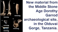
LD 760 molars compared to Australopithecus afarensis. Left molars from Ledi-Geraru specimen LD 760 (left) and Hadar specimen A.L. 400-1 (right). Measurements in mm of the LD 760 molars (length × width): LM1: 13.3 × 13.4, LM2: 14.5 × 14.6, LM3: 14.0 (estimated) × 15.7, RM1: 13.2 × 13.1, RM2: 14.8 × 15.2. Specimens are oriented with their buccal surfaces to the left and mesial surfaces up. Villmoare et al. (2025).

A partial upper molar was also recovered from this locality. This preserves the lingual grove of the tooth, which appears to be quite distinct. In the upper molars of Australopithecus garhi this groove is indistinct. Furthermore, the upper molars of Australopithecus garhi has a greatly reduced hypercone cusp, which leads the protocone cusp to take on a triangular shape. The hypercone is absent in the LD 760 specimen, but the protocone is present, and shows no sign of modification due to a reduced hypercone. However, the sample size for Australopithecus gahri is small, so this cannot be ruled out as a natural variation within the species.

Also found at the LD760 site were a right maxillary (upper) canine, a complete left maxillary lateral incisor and a left fragmentary maxillary central incisor. Thecanine (LD 760-115979) is well  preserved, lacking only the tip of the root. This has mesial and distal interproximal contact facets (wear marks caused by contact between teeth), with the interproximal contact facet having a matching distal interproximal contact facet on the second incisor. This means that the second incisor and canine were in contact, something typical of the the genus Homo, and unlike the situation in many Australopithecus specimens (including the Australopithecus gahri maxilla BOU-VP-12/130) where these two teeth are separated by a diastema (this trait is variable in Australopithecus afarensis, which may-or-may not have a diastema, so this could conceivably also be the case in Australopithecus gahri). The canine is also notably large, towards the upper end of the size range seen in Australopithecus (and much larger than anything seen in Paranthropus).

Comparative maxillary canine morphology. (a) Lingual (left) and  labial (right) views of the Ledi-Geraru LD 760-115979 canine (left) with Hadar Australopithecus afarensis specimens A.L. 763-1 (middle) and A.L. 333x-3 (right). Note that the  LD 760 canine is a right canine, whereas the Australopithecus afarensis canines are from the  left and are mirrored in these images. (b)–(d) LD 760-115979 ((b) shown in lingual view) contrasted with Hadar Australopithecus afarensis specimen A.L. 199-1 ((c) right canine  shown; distal to the upper right) and Bouri Australopithecus garhi specimen BOU-VP-12/130  (d) left canine, mirrored; distal is to the right). Note the simple mesial–distal  chisel-like wear pattern on the LD 760 canine (b) in contrast to the complex  multi-faceted wear pattern of Australopithecus afarensis (c) and the broad curved basin on the  distal side of the Australopithecus garhi upper canine ((d) this is seen on both left and right  canines). Images are oriented differently to emphasise the distinctive relevant morphology. Images in (b)–(d) are not to scale. Vallmoare et al. (2025).

The canine of Australopithecus gahri has a unique structure, with a shallow distal basin reminiscent of a talon which is contiguous with a wide wear furrow which runs along the entire post-canine dental row, something not seen in any other Hominin, and absent in the LD 760 canine. Morphologically, this tooth resembles those of Australopithecus afarensis, however, it has different wear patterns. In Australopithecus afarensis wear is mostly seen on the distal crest, whereas in the the LD 760 canine it is predominantly on the apex, suggesting a difference in diet and/or lifestyle.

The LD 760 individual clearly does not belong to Paranthropus, and is not morphologically consistent with any described species of Australopithecus. However, since it resembles Australopithecus afarensis more closely than anything else, Vallmoare et al. refer it to Australopithecus sp. indet.

The final specimens discussed come from the Giddi Sands unit in the Asboli region. These were found immediately below the 2.593 million-year-old Giddi Sands Tuff, and comprise a partial upper left first molar, and two fragments of an upper left second molar, which can be assembled to form a whole crown. They show little wear, and are close in shape to those of Australopithecus afarensis, although they lack the pronounced lingual occlusocervical sloping and general 'puffy' appearance of the molars of that species. They closely resemble the molars of early Homo specimens such as the 2.3 million-year-old specimen from the Busidima Formation at Hadar, or the 2.5-2.4 million-year-old specimen from Mille-Logya. It is quite different in form from the molars of Australopithecus gahri, and is small compared to the molars of either Australopithecus gahri or Paranthropus

Vallmoare et al. believe that although the Ledi-Geraru material is very limited, it provides clear evidence that both Australopithecus and Homo were present during the 3.0-2.5 million years ago interval, suggesting that multiple non-robust Hominin lineages were present in East Africa before 2.5 million years ago. 

The molar fragments from Asboli sufficiently resemble the Homo specimens from Hadar and Mille-Logya that Vallmoare et al. are confident that they represent the same species. However, they predate the older of these specimens (Mille-Logya) by at least 150 000 years. This adds to the evidence for an early appearance of Homo as Ledi-Geraru previously established by the LD 350-1 mandible, as does the LD 302-23 premolar which Vallmoare et al. describe from the Gurumaha sedimentary package.

The LD 750 and LD 760 material both come from the Lee Adoyta sedimentary package, although they are separated by 24 m of strata and the 2.63 million-year-old Lee Adoyta Tuffs. Nevertheless, both appear to represent a single species of Australopithecus (an assumption based in part upon the unlikelyhood of two similar species of Austrlopithecus coexisting in the same area). 

Vallmoare et al. consider four potential explanations for this material. Firstly, they might represent a late surviving population of Australopithecus afarensis (approximately 350 000 younger than the current youngest member of the species, from the Kada Hadar 2 Submember at Hadar). Secondly, they may represent an unknown species of Australopithecus ancestral to Paranthropus; the presence of Homo in this region implies that the Homo and Paranthropus lineages had diversified by this time, but Paranthropus itself appears to be absent. However, the oldest currently accepted member of the genus coming from about 2.7 million years ago from Nyayanga in Kenya and 2.66 million years ago from the Upper Ndolanya Beds at Laetoli in Tanzania, which makes this scenario less likely. Thirdly, they may represent earlier examples of Australopithecus gahri, which have not yet developed the distinctive features of the 2.5 million-year-old specimen BOU-VP-12/130, although the lack of similarities makes this unlikely. Finally, these specimens represent a new, as yet undescribed, species of Australopithecus.

Villmoare et al. conclude that were at least three species of Hominins present in the Afar Region between 3.0 and 2.5 million years ago, Australopithecus gahri, an unknown species of Homo, and an unknown species of Australopithecus. At the same time, Australopithecus africanus was still present in South Africa, and Paranthropus had already appeared in Kenya, Tanzania, and southern Ethiopia. The Ledi-Geraru environment was drier and more open than was typical for Australopithecus, very much the sort of environment associated with appearance and proliferation of the genus Homo, suggesting that, at least locally, Australopithecus may have been able to adjust to these more open environments, at least for a while.

See also...

Tuesday, 6 August 2024

Using a multivariate analysis of the teeth of Sahelanthropus tchadensis to assess its status as a Hominin.

During the twentieth century palaeoanthropologists searching for the origin of the Hominins became convinced that the group has an East African origin. However, in 2001 scientists from the working on Upper Miocene deposits in the Toros Menalla region of Chad uncovered a group of possible Hominin fossils which they assigned to a new species, Sahelanthropus tchadensis, and which included a nearly complete, is distorted, cranium as well as a mandible and some isolated teeth.

Cranium TM 266-01-060-1, nicknamed Toumai, the holotype of Sahelanthropus tchadensis. Smithsonian Human Origins Program.

If correctly interpreted as a Hominin, then Sahelanthropus tchadensis would be the oldest known member of the group. As such the discovery has been subjected to a considerable amount of scrutiny, particularly as the original specimens had been subject to considerable taphonomic (post-mortem) alteration. One of the problems with the original material was that it was had to interpret the position of the foramen magnum (the whole in the skull through which the brain is connected to the central nervous system) because of distortion of the skull. This is important, because in (upright) Hominins it is located roughly in the centre of the bottom of the skull, while in Apes it is typically towards the back of the skull. A virtual reconstruction of the cranium of Sahelanthropus tchadensis has suggested that the foramen magnum would have been on the base. 

Sahelanthropus tchadensis also has a shorter, more vertical face, reduced canines and a related lack of a honing complex (a gap between the lower canine and the first premolar, into which the upper canine fits, allowing the two canines to rub together and sharpen, or 'hone' one-another), and a downward facing lip on the nuchal crest at the rear of the skull, all of which are Hominin traits. However, it also has a small, Ape-like neurocranium, as well as having a size and number of tooth-roots consistent with an Ape, presenting a mosaic of features consistant with an very early Hominin, or possibly an Ape closely related to the earliest Hominins.

Different analyses of a femur and two ulnae found at the same location as the cranium have suggested both that Sahelanthropus tchadensis was either habitually bipedal, or not habitually bipedal, and that it probably spent at least some of its time in the trees. Since a cladistic analysis has recovered Sahelanthropus tchadensis as a Hominin, this raises at least the possibility that Hominins were habitually walking on two legs 7 million years ago.

One aspect of Sahelanthropus tchadensis which has not been studied extensively is its dentition, despite a number of teeth and tooth fragments being available. In a paper published in the South African Journal of Science on 31 July 2024, Walter Neves, Leticia Valota, and Clovis Monteiro of the Institute of Advanced Studies at the University of São Paulo, present the results of a morphometric analysis which compared the upper posterior dentition of Sahelanthropus tchadensis to that of living Apes and fossil Plio-Pleistocene Hominins.

The upper posterior teeth were chosen as these were the teeth for which the mesiodistal and buccolingual diameters could be determined in Sahelanthropus tchadensis. These were compared to a selection of teeth from Pan troglodytes (Chimpanzees), as well as the Hominins Orrorin tugenensisArdipithecus ramidusAustralopithecus afarensisAustralopithecus africanusParanthropus boiseiParanthropus robustusHomo habilis, and Homo erectus.

For each tooth the ratio between the mesiodistal and buccolingual diameters (length and width) was calculated, and these were plotted on a distribution map. The teeth fell into approximately three groups on this map, one comprising modern Chimpanzees, one comprising the 'Robust Autralopithecines' Paranthropus boisei and Paranthropus robustus, and one containing all other Hominins.

Distribution of the species and specimens included in the study along the morphospace defined by principal component 1 (PC1) x principal component 2 (PC2). Neves et al. (2024).

The teeth of Sahelanthropus tchadensis fell within the non-Robust Hominin cluster, plotting closest to Ardipithecus ramidus, a Miocene-Pliocene species with a large number of known specimens, which again has some Ape-like characteristics, but which is generally accepted as a Hominin by palaeoanthropologists today. Neves et al. interpret this as supporting the hypothesis that Sahelanthropus tchadensis is a Hominin rather than an Ape.

See also...

Sunday, 5 November 2023

Evidence for shoes in the Middle Stone Age of the Cape Coast, South Africa.

The appearance of clothing is considered to be one of the key stages in the development of Modern Humans, and the development of footwear, a complex form of clothing, is in itself an important technological leap. However, the exact time when footwear first appeared is unknown, with the first foot-coverings presumed to have been made of perishable materials unlikely to have survived. In the absence of preserved footwear, ichnology (the study of tracks and traces) provides the most plausible technique for detecting the first use of footwear among Hominins.

The oldest known shoes in the archaeological record are sandals made of woven Sagebrush bark from Oregon in the United States, the oldest of which have been dated to between 10 500 and 9200 years old. Also from the United States, a variety of sandals, moccasins, and slip-on footwear have been uncovered in Missouri, dating from between 8000 and 1000 years ago. The oldest shoe from Eurasia is a leather wrap-around shoe from southeastern Armenia, dated to between 5600 and 5400 years ago. Also from Eurasia, ‘Ötzi the Iceman' a frozen natural mummy found in the High Alps on the border between Austria and Italy, dated to more than 5000 years old, had a complete set of clothing, including complex footwear made from Bear-skin, Deer hide, and tree bark. A pair of Cow-hide sandals from Israel has also been dated to more than 5000 years ago.

Hominin trackways are known from many sites around the world, and can be identified by features such as the alignment and shape of the hallux, relative digit lengths, and the presence of a prominent medial longitudinal arch. However, these identifying features are based upon the assumption that the track-maker was unshod, and it is unlikely that all would be present were they to have been wearing some form of foot-covering. Thus, unsurprisingly, the majority of known Hominin tracks are considered to have been made by unshod tracemakers, although a few exceptions are known.

The oldest apparently shod Human tracks in the Americas are in Jaguar Cave, Tennessee, which are thought to be about 5000 years old. In Europe such traces include traces associated with a Magdalenian (Upper Palaeolithic) tool assemblage in Fontanet Cave, France, which appear to have been made by an individual wearing a soft shoe or sock. Also in France, Cussac Cave, footprints associated with a Gravettian assemblage and dated to between 38 000 and 31 000 years ago lack any digit impressions, despite these being present on both Human handprints and Bear footprints within the same cave, leading to the possibility that the trace-makers may have been shod.

Footprints without digit impressions are also known from a third site in France, Le Rozel, although these are about 80 000 years old, implying that the trace-makers were Neanderthals rather than Modern Humans. Possible evidence for footwear use by Neanderthals comes from Theopetra Cave in Greece, where a mixture of shod and unshod traces appears to have been left by a group of children around 130 000 years ago.

In South Africa, a number of possible footwear traces have been found on the Cape Coast, an area noted for its excellent Pleistocene tracks, including one trace which appears to show a clear sandal-imprint.

The use of clothing is thought to have been developed by Hominins inhabiting cool environments during Pleistocene cold spells, although the perishable nature of the material from which such cloths are likely to have been made, makes it unlikely that any preserved material will ever be found. Instead, tools used for the processing of skins, leather, and textiles are used as proxies for the materials themselves. This begins with the appearance of scrapers presumed to have been used for the preparation of skins, shortly followed by bone awls, needles and eyed needles, which imply the manufacture of increasingly complex clothing. Based upon this, it has been calculated that the first simple clothing probably appeared around 800 000 years ago, long before the emergence of Modern Humans, with several different Hominin species probably manufacturing and wearing cloths, with the possibility that footwear appeared at the same time. Molecular clock analysis suggests that Body Lice probably diverged from Head Lice between 170 000 and 80 000 years ago, by which time is is assumed that Humans were habitually wearing cloths all the time.

The Contrebandiers Cave site in Morocco, which has been dated to between 120 000 and 90 000 years ago, has yielded a variety of bone tools thought to have been used for the processing of leather and furs, but for the most part Pleistocene sites with evidence for tools likely to have been used in clothing manufacture and tracks made by Hominins are restricted to two areas, Western Europe and the Cape Coast of South Africa.

Such tools in Europe are known from the Middle Palaeolithic of southwestern France, with the oldest dating to about 51 400 years ago, and other examples between 48 000 and 41 000 years ago. These tools were presumably made by Neanderthals, and include lissoirs, tools which can be used to process hides, giving a smooth, tough, and reasonably impermeable finish (although not the same as modern commercially produced leathers).

The oldest sites in South Africa yielding tools which could have been made for making cloths are at Klasies River and Blombos Cave on the Cape Coast, with the Klasies River site dated to about 100 000 years ago and Blombos Cave mostly to about 80 000 years ago, although one awl, made from the bone of a Bird, was dated to at least 125 000 years ago.

Although these tools are taken as the earliest tools which are clearly associated with clothing manufacture, in both Europe and South Africa earlier stone tools could have been used to cut or pierce hides during the manufacture of simple garments, as could sharpened shell tools known from the Cape Coast. However, the fact that the oldest surviving footwear was made from woven Sagebrush rather than leather does suggest that caution should be applied when judging what ancient populations would have seen as suitable materials for making footwear.

It has also been suggested that wearing shoes might affect the way in which the foot develops, something which has been implied for a set of Human remains from Tianyuan in China dated to about 50 000 years ago, although the phalanges of the foot are seldom well preserved, limiting the number of instances in which this method can be applied.

Another Upper Palaeolithic site at Sunghir, in northern Russia, yielded a buried individual with remnant body decoration implying leggings or boots, as well as having extremely gracile lateral phalanges, something thought to be associated with habitual shoe wearing. This was particularly surprising as all Upper Palaeolithic Hominin tracks from Eurasia appear to have been made by barefoot trace-makers.

The relationship between footwear and foot morphology is complicated. Individuals who minimise their use of footwear are thought to have stronger foot muscles, and fewer pathologies of the feet, but this would be unlikely to result in any detectable skeletal difference between someone who never wore shoes and someone who occasionally did so, or even somebody who habitually wore very lightweight shoes.

In a paper published in the journal Ichnos on 28 August 2023, Charles Helm of the African Centre for Coastal Palaeoscience at Nelson Mandela University, Martin Lockley, also of the African Centre for Coastal Palaeoscience at Nelson Mandela University, and of the Dinosaur Trackers Research Group at the University of Colorado Denver, Hayley Cawthra, again of the African Centre for Coastal Palaeoscience at Nelson Mandela University, and of the Minerals and Energy Unit at the South African Council for Geoscience, Jan De Vynck, again of the African Centre for Coastal Palaeoscience at Nelson Mandela University, and of the Evolutionary Studies Institute at the University of the Witwatersrand, Mark Dixon, again of the African Centre for Coastal Palaeoscience at Nelson Mandela University, Renée Rust, again of the African Centre for Coastal Palaeoscience at Nelson Mandela University, and of the School of Geography, Archaeology and Environmental Studies at the University of the Witwatersrand, Willo Stear and Monique Van Tonder, once again of the African Centre for Coastal Palaeoscience at Nelson Mandela University, and Bernhard Zipfel, also of the Evolutionary Studies Institute at the University of the Witwatersrand, describe three Middle Stone Age sites on South Africa’s Cape Coast where tracks appear to have been made by Hominins wearing shoes, and discuss ways in which future studies of this topic could be approached.

Map of the Cape Coast of South Africa, showing Cenozoic deposits and places mentioned in the text. Helm et al. (2023).

Scientists from the African Centre for Coastal Palaeoscience have been studying the trace fossils of the Cape Coast since 2007. Here, a 350 km section of coast has frequent coastal aeolianites (wind-blown sand deposits) which have been buried by subsequent similar deposits than set with a carbonate cement, preserving a record of the people and animals which moved over them during the Middle Stone Age. As well as trackways left by Hominins, these studies revealed imprints left by Crocodiles, Giraffe, breeding Sea Turtles and very large Tortoises, none of which have left skeletal remains in the area.

The Cape Coast region has a remarkably rich archaeological record, tracing the appearance and development of numerous stages considered key steps on the way to Modern Human behaviour, including personal adornments, jewellery, the heat treatment of stone tools, art, and the use of abstract symbols. Palaeoclimatic studies of the same region indicate that the coastal plains upon which these deposits were laid down went through a cycle of exposure and inundation throughout the Pleistocene, which probably helped to maintain an ideal Hominin environment in the region. 

Prior to this project, Hominin tracks had previously been discovered at Langebaan on the west coast of South Africa, and Nahoon on the east coast of the country. Extensive study of the Cape Coast has produced four new track localities, and while another probable set of tracks has recently been identified at Langebaan. Combined with a set of tracks on an ancient lakebed in the Nefud Desert of Saudi Arabia, this represents the entire global inventory of tracks more than 46 000 years old which are attributed to Modern Humans.

All of the Hominin tracks on the Cape Coast are within the aeolianites of the Waenhuiskrans Formation, which together with the cemented foreshore, shoreface and lagoon deposits of the Klein Brak Formation, comprise the Bredasdorp Group. These deposits have been dated to between 400 000 and 36 000 years old, although the majority belong to Marine Isotope Stage 5, making them between 130 000 and 80 000 years old. To the east of Robberg, the correlate of the Waenhuiskrans Formation is the Nahoon Formation, which forms part of the Algoa Group. These Pleistocene aeolianites split readily along their bedding planes, so that tracks are often exposed on fallen blocks on the coast. Thes blocks are ephemeral, quickly being eroded away by the action of the waves.

Due to this ephemeral nature, tracks needed to be recorded quickly when exposed. This was done by recording their locality with a GPS unit and taking numerous photographs, which were then used to build photogrammetric models. Exposed trackways and footprints were also measured for track length, track width, track depth, pace length, stride length, and thickness of foresets, and individual footprints were examined for evidence of strap attachment points. 

In addition, studies were made of newly created tracks on sandy surfaces on the Cape Coast, with varying levels of moisture, slope, and firmness, and a variety of shoe types, including shoes with an open soft sole, an open hard sole, a closed soft sole and a closed hard sole. The best match for the fossil footprints was made by using an open hard soled shoe on soft, moist sand.

Shoe designs for this study were based upon shoes made by examples of sandals made by San peoples of southern Africa from the collections of the Blombos Museum of Archaeology in South Africa and Zambezi Heritage Museum in Namibia. The shoe which gave the closest results to the preserves footprints was based upon two such sandals, and was made from two layers of Cow-hide glued together, and laced by piercing three holes through this sole, one between the big toe and the adjacent digit, and two about half way along the length of the shoe, one at each side. The laces were made from the same Cow-hide as the upper part of the shoe, and were threaded through the holes and knotted underneath, protruding below, although in the museum examples prolonged use had levelled out the knots with the base of the sole. These sandals proved easy to attach to the foot.

Helm et al. present details of three footprint-bearing sites on the Cape Coast, these being, from west to east, Kleinkrantz, Goukamma, and Woody Cape.

At Kleinkrantz a slab measing 55 cm x 55 cm and 20 cm thick with apparent footprints on its upper surface, was found lying on a modern coast dune beneath a vegetated slope, which in turn lies beneath a cliff with an exposure of the Waenhuiskrans Formation. There was no sign of a recent rockfall, and samples taken from the Waenhuiskrans Formation in this area have been dated to between 148 000 and 79 000 years old.

(A) The Kleinkrantz site in the Garden Route National Park; scale bar is 10 cm. (B) Photogrammetry colour mesh of the Kleinkrantz site, using 48 images. Photos were taken average 36.4 cm from the surface. The reprojection error is 0.39 pix. Vertical and horizontal scales are in metres. Arrows indicate possible strap attachment point impressions. Helm et al. (2023).

This slab has two similar depressions, one in front of the other, each with crisp three crisp and well-defined margins, two straight parallel, the third near semicircular. One of these appears to have been a double impression, with a slightly narrower impression overlying an slightly wider one. The wider of these is 9 cm wide, the narrower 7 cm, while the single impression is 8 cm wide. Both features are at least 16 cm long. The narrowest impression also has three depressions within it consistent with the position of the strap knots on the experimental sandal.

Two other possible track prints are also present, although these are more amorphous, and were apparently made by a person travelling in a different direction, though again possible strap-attachment knot impressions are present. 

The second site lies within the Goukamma Nature Reserve, between Sedgefield and Knysna, where the Waenhuiskrans Formation has been dated to between 136 000 and 79 000 years old, although recent dates obtained suggest parts of the formation may be as young as 73 000 years old. Here a fallen slab has three footprints with crisp margins and no signs of digits, one of which particularly resembles the imprint of a shod foot. This print measures 11.5 cm in length and 6 cm in width.

(A) The Goukamma surface; scale bar = 10 cm. (B) Angled view of the Goukamma site; scale bar is 10 cm. (C) Photogrammetry colour mesh of the Goukamma site, using 59 images. Photos were taken average 29.9 cm from the surface. The reprojection error is 0.39 pix. Vertical and horizontal scales are in metres. Helm et al. (2023).

The third site, Woody Cape, is situated in the coastal portion of the Addo Elephant National Park. Here a detached slab from the Nahoon Formation shows a trackway comprising four footprints, one of which is partial. The prints are 10-12 cm long and 5-6 cm wide, with a pace length of 19 cm. Raised areas to the left of each print imply some downslope movement.

Photogrammetry colour mesh of the Woody Cape site, using 37 images. Photos were taken average 29.2 cm from the surface. The reprojection error is 0.57 pix. Vertical and horizontal scales are in metres. Helm et al. (2023).

Helm et al. also attempted to recreate a trackway similar to the Pleistocene examples, using a hard-soled sandal based upon museum specimens, on a modern, moist, soft, level dune surface. This produced footprints with slight out-toeing about 26 cm in length, with a width of 11.5 cm and a pace length of 63 cm. The front and back margins of the prints were semicircular, the sides parallel. Strap attachment marks can be seen.

Photogrammetry colour mesh of the neoichnological trackway (level surface, hard-soled sandal, soft substrate) using 63 images. Photos were taken average 37 cm from the surface. The reprojection error is 2.07 pix. Vertical and horizontal scales are in metres. Helm et al. (2023).

Helm et al. accept that the evidence they provide cannot be seen as irrefutable, however, the presence of similar tracks at three separate sites, combined with the recreation of similar prints with a pair of modern sandals based upon a historic design, does strongly suggest that similar sandals were being worn by Humans in the area more than 70 000 years ago. All three sets of footprints appear to have been made by trackmakers smaller than modern adult Humans, suggesting that they were either adults of smaller stature, or children.

A pair of sandals on exhibit in the Blombos Museum of Archaeology in Still Bay, viewed from above (A), and below (B), showing strap attachment points; scale bars are 10 cm. Helm et al. (2023).

The tracks of bare feet are distinctive, due to the presence of digits and the raised arch of the foot. The impression likely to have been made by a shoe of unknown design is less easy to predict, but it is likely to have followed the general plan of a Hominin footprint, i.e. twice as long as wide, and soft foot-coverings may still preserve the presence of an arch, and rounded front and back margins. It is also quite likely that the front portion of the print will be wider than the rear portion, and that the curve of the front and back parts of the foot will be different. Trackways will reflect the fact that Hominins are bipeds with a narrow stride. In some cases, distinctive traces may be made by the footwear, such as attachment marks from straps.

A pair of sandals on exhibit in the Zambezi Heritage Museum in Katima Mulilo, Namibia, viewed from above (A), and below (B), showing strap attachment points; scale bars are 10 cm. Helm et al. (2023).

Previous attempts to recreate impressions likely to have been made by ancient footwear mostly concentrated on the use of soft leather shoes by persons walking over clay substrates. These studies found that shod tracks were typically longer and narrower than unshod tracks, and that this became more exaggerated as the substrate got moister and the footprints deeper. Shod footprints were also typically simpler than unshod ones, most obviously in the lack of toe-prints. 

These findings may have some implications for studies being carried out on the Cape Coast of South Africa, where some footprints have been considered questionable due to their apparently elongate shape.

Historic sandals in the collections of museums shed light on the appearance of shoes within the region in the recent past, and therefore possibly those that might have been used by people in the remote past armed with similar resources and environmental challenges. These sandals are remarkably symmetrical, with little difference between the width of the front and rear portions of the shoe. The pair from the Zambezi Heritage Museum in Namibia are believed to have been made from Buffalo hide in the 1920s.

The San people who made these sandals are known to have used a variety of Animal skins, with different groups using specific hides, including Eland, Hartebeest, and Wildebeest, while other Animals, such as Gemsbok, were avoided by all groups. Furthermore, different types of sandals were made for different purposes, including special shoes for seniors, shoes for uphill travel, and running sandals with a hook under the toe giving extra purchase when running over soft sand (possibly in imitation of the foot of an Ostrich, the fastest bipedal Animal present in the region).

A pair of ‘running sandals’ in the Fourie Collection in Museum Africa, accession number MM40-69-2416; scale bar is 10 cm. Justine Wintjes in Helm et al. (2023).

Rock art in Southern Africa also provides a record of the use of footwear in the region, albeit one that only stretches back a few thousand years. The artwork at Baviaanskloof in Eastern Cape Province is thought to be about 2000 years old, and includes a 21 cm high figure interpreted as a shaman, naked apart of a pair of laced sandals and a kaross (cloak made from Animal skin). The fact that a largely naked figure is wearing elaborate sandals suggests that these were important items to the people of the region.

(A) A male figure, apparently with footwear and shoelaces (magnified in inset), in a San pictograph from Baviaanskloof.  (B) Rock art of footwear that appears to depict shoelaces, Baviaanskloof. Helm et al. (2023).

In total, four figures with footwear are present within at Baviaanskloof, two of which have identifiable laces. Sandals can also be seen in the rock art of the western US, where Pueblo petroglyphs made between 1000 and 1200 AD also depict footwear.

Helm et al. note that the identification of tracks made by Hominins with footwear can be difficult, and suggest a set of criteria which may make this easier for future researchers. Firstly, any trackway examined should be of sufficient length for the study to be useful. Secondly, Hominins are bipedal, with a narrow gait, and any track made by them should reflect this. Thirdly, Hominin footprints are roughly twice as long as wide, regardless of footwear. Fourthly, Hominin tracks tend to have rounded fronts and backs. Fifthly, any trackway analysed for the presence of footwear should be of sufficient quality, with crisp margins. Sixthly, shod footprints will lack the diagnostic features of unshod footprints, such as digit marks. Finally, the footprints may have diagnostic features associated with the footwear, such as strap attachment points.

See also...

Follow Sciency Thoughts on Facebook.

Follow Sciency Thoughts on Twitter.


Monday, 3 July 2023

La Roche-Cotard Cave Art confidently assigned to Neanderthal artists.

Since the 1980s an increasing body of material has been assigned to cultural expression by the Neanderthal people, although symbolic material produced by Neanderthal artists remains extremely rare. This material includes a number of carved bones and rocks, a variety of modified shells, and a selection of feathers and Raptor claws apparently modified for use as personal ornamentation. A number of pigments are known to have been used by Neanderthals, although these potentially have other uses than pigmentation, making their purpose hard to assess. Other artefacts are less easy to interpret, such as the 'Mask of la Roche-Cotard', thought to be about 75 000-years-old, a piece of flint which may have been shaped to resemble a face, with a bone pushed through in a way that might represent eyes, or the Bruniquel Cave construction, where, in a large chamber located more than 300 meters from the entrance, many stalagmites have been deliberately broken and placed on the ground to form a large oval structure, around 170 000 years ago. A variety of other symbolic behaviours are associated with Neanderthals, including ritual burials, although many of these are difficult to interpret. What is clear, however, is that Neanderthals did engage in symbolic behaviour, and that the expression of this changed considerably over time.

The 'Mask of la Roche-Cotard', a 75 000-year-old Neanderthal artefact in the collection of the Museé de l'Homme in Paris. Thilo Parg/Wikimedia Commons.

A variety of engraved markings, clearly different to functional cut marks, have been found on rocks, bones, shells, and other items from Middle Palaeolithic sites in Europe and the Middle East. The engraved phalanx of a Giant Deer has been found at an archaeological site Einhornhoehle in Germany, in a level dated to more than 47 000 years ago. A phalanx and eight talons of an Eagle, with cut marks, evidence of burning, and traces of ochre, alongside Mousterian tools, and Neanderthal bones was found at Krapina I in Croatia. (the Mousterian industry is closely associated with Neanderthals in Europe, where it appeared about 160 000 years ago and vanished about 40 000 years ago). One of the Neanderthal bones at Krapina I, a frontal (forehead) has 35 cut marks upon it. A set of Bird bones from Fumane Cave in Italy, dated to between 44 800 and 42 200 years ago show signs of having been cut with a flint blade in a way intended to facilitate the intact removal of large feathers, while in the same cave a fossil shell covered with ochre was recovered from a Mousterian layer. At the Zaskalnaya VI Neanderthal site in eastern Crimea a Raven bone was found with a series of parallel, equidistant notches cut along its main axis. The Los Aviones Mousterian Site, in the Murcia region of southern Spain, has produced marine shells modified in several ways, including shells with perforated umbos and shells showing signs of having been coloured with haematite. Other artificially coloured shells have been found at Anton Cave, also in Murcia. At Quneitra in the Golan Heights, where Neanderthals and Modern Humans are thought to have had a long period of co-existence, a Levallois flint core, 8 cm in length has been found which has been engraved with a pattern of straight parallel lines and semi-circular concentric lines, which are apparently entirely decorative in function. At Gorham’s cave, Gibraltar, a layer containing Mousterian material covered a cave floor carved with geometric designs. The Ardales, Maltravieso and La Pasiega sites, all in Spain, all have markings made on cave walls with a red pigment, which are overlain by a calcite flowstone cement, from which uranium-thorium dates have been obtained which imply Neanderthal artists. However, this has been disputed, dates being a common problem with material thought to be of Neanderthal origins, with most of the material described being identified as Neanderthal by its association with Mousterian tools rather than directly dated.

The La Roche-Cotard Cave in central France was revealed by quarrying in 1846, and excavated by the then owner of the site, François d’Achon in 1912, revealing a number of Mousterian artefacts. Subsequent excavations in the 1970s and from 2008 onwards, have found three additional archaeological sites close to this cave. The sites are numbered in the order they were discovered, with the original cave been LRC I, an open air site at the foot of a nearby cliff being LRC II (which produced the 'Mask of la Roche-Cotard'), a small rockshelter being LRC III, and a smaller cave and associated trench being LRC IV. All of these sites have produced Moustrian artefacts, apart from LRC II, which produced only the enigmatic 'Mask'.

During the 1970s and modern campaigns it was observed that the walls of cave LRC I are marked by finger flutings (gouges into soft rock made with fingers), and in places spotted with red ochre. The walls also have a range of other markings, including scratch marks attributed to Animal claws, smooth patches thought to have been cause by rubbing, again probably by an Animal, percussion marks left by metal tools, presumably in 1912, and a single piece of graffiti, known to date from 1992. 

In a paper published in the journal PLoS One on 21 June 2023, a team of scientists led by Jean-Claude Marquet of the Laboratoire Archéologie etTerritoires and GéoHydrosytèmes COntinentaux at the Université de Tours, formally describe the fingermarks in the LRC 1 cave as intentional engravings, and provide dating evidence which indicates the makers must have been Neanderthals.

The cave is located on a 100 m high plateau in the Touraine Region, which is covered by crop-fields and woodland, and made up of Cretaceous marine sedimentary rock. The Loire Valley cuts through the plateau, to a depth of about 50 m, with the La Roche-Cotard site on the northern side of this valley. The cave, LRC I, is cut into Upper Turonian (Late Cretaceous) soft, sometimes crumbly, sandy yellow limestone. The top of the plateau is covered by a thin layer of silty sand, about a metre thick, which accumulated as a wind-blown deposit during the last glacial. The bedrock is not generally visible on the sides of the plateau, except where it has been exposed by Human activity, having been covered over by solifluction or runoff. The cave appears to have been repeatedly flooded by the River Loire, which is also likely to have been at least partially responsible for its dissolution. While in the Holocene, all of the La Roche-Cotard sites were covered by sediments until these were removed by Human activities in the nineteenth and twentieth centuries, in the Late Pleistocene the River Loire was closer to the base of the slope, and would have rapidly removed such sediments, keeping the area accessible to both Animal and Human inhabitants of the region. During the early Holocene, the river shifted its course to the other side of the valley, and sediment began to accumulate, covering the area until much of it was removed in the 1840s to use as building materials for the construction of the Loire Valley Railway.

Location and map of La Roche-Cotard. (A) and (B) Geographical and geological location of La Roche-Cotard. (C) Map of the main Mousterian sites in central-west France. Marquet et al. (2023).

The La Roche-Cotard Cav is about 33 m deep, running southeast-to-northwest, with four main chambers; the Mousterian Gallery, the Lemmings Chamber, the Pillar Chamber and the Hyena Chamber. It may have extended further back in the past; the rear of the Hyena Chamber having collapsed at some point. The soft rock from which the cave is made also contains large slabs and knobs of harder, silicified sediment, which appear to have lent some structural strength; the ceiling of the cave is a silicified layer (the Langeais Hardground), which marks the base of the e Coniacian Epoch.

La Roche-Cotard site. (A) Map of La Roche-Cotard with its four loci: LRC I, LRC II, LRC III and LRC IV. In blue: location of anthropogenic marks. (B) Profiles of slope sections (red lines in (A)) with location of sediments extracted in 1846. Marquet et al. (2023).

The cave opens into the Mousterian Gallery, which has a quartzite sandstone floor, 49.2 m above the Nivellement Général de la France (general levelling of France), and a ceiling 51 m above the same, made from silicified biocalcarenite. at the west end of this chamber a passage 2 m high and 1.5 m wide leads to the Lemmings Chamber. This has two small openings to the outside on its eastern side, and a large passage leading to the Pillar Chamber at its northwest. This chamber has a large central pillar, and a large quartzite slab which forms an extensive platform several tens of centimetres above the floor of the chamber. This has been broken at the north end of the chamber, though a section is still attached to the north wall; this part of the chamber still contains a considerable amount of sediment. The Hyena Chamber can be reached from the Pillar Chamber via a narrow, sinuous passage.

Description of La Roche-Cotard Cave (locus LRC I). (A) Lithological map of the cave floor. (B) XY section in the Pillar and Lemmings Chambers (location in (A)). The elevation of the ground surface increases steeply from the entrance to the Lemmings Chamber, and then only very slightly from southeast to northwest till the Hyena Chamber (1.5 m). 95% of the sediments that occupied a large part of the cave were removed during the 1912 excavation. Layers to the southeast: Middle layer (b), Upper layer (a), Disturbed layer (r). Layers to the northwest: Compact clayey layer with tuff gravel with bone fragments and coprolites (3). Sandy layer with soft reddish clay pebbles (4). Disturbed layers: (1), (2) and (r). The three arrows show the place of the overhang (50.75 m Nivellement Général de la France) extending from the entrance of the cave to the Pillar Chamber. Marquet et al. (2023).

Methodical exploration of the La Roche-Cotard sites began in 2008. Remains attributed of large, medium, and small Vertebrates were uncovered on several levels, and studied systematically, although a palynological analysis was not possible, as the environment comprised porous sediments through which well-oxygenated water had been able to percolate. The location of any lithic remains and faunal remains greater than 2 cm were carefully mapped; sediment samples were then sieved for smaller faunal remains.

Most of the sediment from the LRC I cave was removed in 2012, but sufficient was left within the Pillar Chamber to establish a stratigraphic sequence, with a sandy layer with soft reddish clay pebbles filling a small natural funnel formed in the tuff by water at the base, over which was a compact clay layer with tuff gravel, bone fragments, coprolites, and then two modern, disturbed layers, although none of these can be correlated to any sedimentary unit identified elsewhere. The area in front of the cave entrance produced a very sandy Lower Layer, overlain by a Middle Layer consisting primarily of silt from overflowing of the Loire, and an Upper Layer formed of gelifracts (sloping beds leaning against a rock face) and aeolian sand.

Outside of the cave, five sedimentary units were found across the area. The lowest layer is mainly composed of tuff blocks separated by voids filled with sandy reddish clay, with areas of brown to greenish-yellow, fine silty sand with largely subordinate clay; this layer is thought to be largely derived from weathering of the underlying rocks. The layer above this consists of sandy to silty brown to greyish layers, which are only slightly or not at all carbonated, thought to have been laid down as bottom deposits within the River Loire, at a time when its meandering covered the sites. The third layer consists of a light brown carbonated matrix, with abundant frost-fractured quarzitic sandstone slabs and a few sandy blocks, thought to be a mixture of material that has moved downslope in a landslip. The penultimate layer is brown and texturally selected. It is made up of slightly carbonated fine-grained sand and silt, and its upper limit is tilted toward the south; this layer is thought to comprise aeolian material blown in during a Pleistocene dry phase. Finally, the uppermost layer, which presumably extended everywhere on the slope before 1846, consists of brown to greyish, very heterometric sedimentary layers composed of a dominant silty sand matrix with variable abundance of flint and limestone fragments, thought to be the result of Holocene soil formation, with perioding inclusions of runoff material from the slopes above.

Much of the sediment that filled the cave was removed by François d’Achon in 1912, but sufficient remained for Marquet et al. to develop a stratigraphy for the cave interior. The conduit connecting the Lemmings Chamber to the exterior still contains an undisturbed sequence, comprising two layers, the lower of which Marquet et al. equate to the river sediment layer found outside the cave, and the upper the landslip material which overlies this. In the main cave entrance two niches are again filled with river sediment, while in front of the entrance more of this sediment is covered by a large block of fallen limestone. Some smaller tunnels above the cave were found to be filled with the soil which forms the uppermost layer elsewhere, and a trench excavated above the cave entrance found the same, while a cave excavated below the entrance found a more complete stratigraphic sequence.

Lithostratigraphy and geometric distribution of the superficial deposits outside the cave. (A). Block diagram with loci positions and in particular the sub-loci LRC I-a to d. The stratigraphy of the layers intersected by LRC II (B), LRC III (C) and LRC IV (D). For each locus, the stratigraphic units (U5/red, U4/blue, U3/brown, U2/orange, U1/green) and their vertical extension is indicated. Each unit comprises several layers. Marquet et al. (2023).

Based upon this, Marquet et al. conclude that, at some point after the cave was formed, it was entered by the river, which filled it to a height of at least 60 cm. Some time after the waters receded, the entrance the entrance of the cave was sealed by a landslip, with subsequent Pleistocene and Holocene sedimentary layers forming over this, probably forming a layer about 10 m thick before quarrying began in the 1840s.

Location of undisturbed deposits near the LRC I cave entrance. The map locates the two orthophotos in the centre of the figure. The entrance of the cave, on the left orthophoto, is underlined in black. The dashed horizontal line corresponds to the altitude of the overhang to the pillar room as well as to the lower limit of the ceiling of the cave entrance. Below, the LRC II photograph shows only the upper part of the stratigraphy of this locus, marking the period when sediments began to deposit on the slope. On the left, LRCI-a shows the middle and upper layers inside and outside the cave. Bottom right, LRCI-b  also illustrates the same middle layer as found in LRCI-niches 1 and 2, but inside the cave entrance. LRCI-c shows the location of sediment remnants trapped in ancient and small galleries created by erosion in the hard cretaceous stone, belonging to the deposit which completed the sealing of the entrance. LRCI-d shows sediments very similar to those of LRCI-c which continued to accumulate for some time after the cave was closed. Altitudes are given to clarify the location of these different sections. The lower view of LRC I-niche 2 is from 1975. Marquet et al. (2023).

François d’Achon's 1912 excavations recovered a considerable amount of large- and medium-sized Animal remains within the cave, but their locations were not recorded. The more recent excavations also found significant amounts of such remains, principally at the LRC III and LRC IV sites, the locations and stratigraphic placement of which were carefully recorded. Some of the bones from all four locations show signs of Human activity, including cut marks, burning, and modification for use as tools. Most of the remains appear to have come from Animals that would have occupied the area during temperate phases, such as Bison and Aurochs, Equids and Red Deer. A sequence of predators could also be established, with the area first being used by Cave Lions and Bears, then by Humans, and lastly by Hyenas. In some places an upper faunal layer, comprising cold-period species, such as Marmot and Reindeer, was present. Remains of smaller Vertebrates, including Mammals, Fish, Amphibians, Birds, and Reptiles, were recovered by sieving sediments. 

All four sites also produced Human-manufactured tools. All of these belonged to the Mousterian lithic assemblage, with no later material found. François d’Achon uncovered two assemblages of lithic artefacts within the cave LRC I, although all of these have subsequently been lost, with only a single photograph and some drawings surviving to the present day. The tools are made from Lower Turonian flint, which is available in the form of pebbles in the river terraces. The items documented include a number of Mousterian bifaces in the top part of the lower layer in a corner of the Pillar Chamber, and debetage (flakes) apparently produced using a Levallois technique (the progressive removal of flakes from a prepared core by striking with a percussive tool), within upper part of the lower layer close to the cave entrance, beneath a stone structure which d’Achon believed was a fireplace. Marquet et al. uncovered another Mousterian biface in the South Pillar Chamber, d in the remnants of an unidentified layer. They also found some thin elongated flakes in the lower layer of the Mousterian, at a depth below that to which d’Achon had excavated. Another blade was found on the top of the lower layer within the Pillar Chamber, though this is difficult to place stratigraphically.

Map showing the location of lithic industry discoveries. The two brown zones 1 and 2 locate François d’Achon’s discoveries (1. typical Mousterian with Levallois flaking, surmounted by the Mousterian of Acheulean tradition, 2. typical Mousterian with Levallois flaking). The three green zones locate recent discoveries (3, 4 and 5. Typical Mousterian with Levallois debitage). Marquet et al. (2023).

Levallois flakes were also found at the LRC II site, in the same layer as the 'Mask of La Roche-Cotard', at the LRC III site, below a layer of faunal remains apparently gnawed by Hyenas, which in turn was below a layer with the remains of Arctic Lemmings, and Narrow-headed Voles (both Arctic-adapted Rodents), neither of which layers produced any tools. At LRC IV, more Levallois flakes were found associated with the bones of cool temperate large Mammal remains, and overlain by a layer containing the remains of Arctic Lemmings, but no tools.

The Mousterian industries of La Roche-Cotard discovered in 1912. Mousterian of Acheulean Tradition bifaces discovered in 1912. Marquet et al. (2023).

Thus all of the lithic items which can be placed within a stratigraphic context (i.e. everything but the items from the Pillar Chamber, clearly comes from the same deposit, which records a warm period followed by a glaciation, and all of the items belong to the Moustrian technology, which is clearly associated with Neanderthals in Europe. None of these items show any sign of having been transported by water. 

Traceology of the broken biface and of the small blade discovered in 2009. (A) Broken triangular flint biface discovered not deeply in the sediment accumulated in a window of the chert layer. It shows significant rounding of its distal part (1, 2, 3), creating a dull, abrupt edge most probably produced by transverse contact with mineral matter. The other edges of this implement do not display such characteristics. (B) Second stone implement, made on a blade, used to process mineral matter and hide. Three zones of use are identified: the first suggests hide processing (1). The second and third use-areas present features which indicate scraping soft, abrasive, mineral matter (2, 3). Marquet et al. (2023).

A variety of markings are present on the walls of the La Roche-Cotard Cave. Some of these marks are clearly the result of Human activity, but others can be attributed to Animals, such as Bears or Badgers, or chemical processes, such as surface dissolution, disintegration, dehydration, and concretion formation. Markings made by the claws of Animals typically have a characteristic spacing and incision angle, depending on the type of Animal involved, whereas Human markings are much more variable, and include spatially organized elongated marks and patterns of dots unlike anything any Animal will make. Such marks are found on a 13 m-long section of the northeast wall of the Pillar Chamber. The marks are aranged in distinct geometric patterns, which are grouped together to make a series of distinct panels linked by groups of smaller marks. A linear discrimination analysis of the width, incision angle and depth of 116 marks revealed two statistically distinct groups: 32 with features consistent with claw marks, while the remaining 84 appeared to be of Human origin. This was based upon the assumption that Animal claws will make shallow marks with a v-shaped profile, while a finger or finger-shaped tool with make deeper, often u-shaped marks (this was confirmed experimentally on a section of similar tuffaceous limestone intentionally uncovered close to the cave). The Human-made markings were aranged in eight separate panels, apparently reflecting two separate aproches to art-making,, with the six panels being similar, and probably made with fingers, while the two were distinct, and apparently made with a tool, although it was not possible to identify the type of tool used.

Approach used to measure traces. The first four images show the Triangular Panel (TRI), the Rectangular Panel (REC), the bear scratched area (CLA) and finally the Circular Panel (CIR); at the bottom of each picture, the cross-sections made with CloudCompare on the photogrammetries. Four cross-sections were made on the Triangular Panel, T1 to T4 and six on the circular, C1 to C6. Only T1 and C6 are presented below each panel. The cross-sections on the Rectangular Panel have too little relief to allow measurements. The measurements of the width and the angle of incision of the line were carried out using the CloudCompare application and the depth was calculated using a simple mathematical formula: depth equals width over 2 times the tangent (incision angle/2). The same method was used for the scratched space because of the multiple crossings of the traces on the wall. The following five photos show experimental traces made to hypothesise which tool or tools might have been used to make the tracings of the Rectangular Panel. Among the 7 tools that were used for this experiment, only five panels are shown: WOOA traced with an antler point, WOOV with a wood point, FLIN with a flint point, BONE with a bone point and FING with a finger positioned flat. In each image the location of the cross-sections that have been made can be seen; only one is presented below the photo. The iron point tracings were less interesting and the finger positioned on edge was used very little as blood was easily lost when the finger passed over the very aggressive surface of the wall. On these 5 panels, all measurements were made directly on the sections that appear on the sections made. All the scales are in metres. Marquet et al. (2023).

All of the panels are found on a section of wall showing a thin layer of chemically altered material, above a horizontal overhang attributed to the pooling of water (which would have eroded the cave wall at the base). Below the overhang the wall has numerous niches attributed to dissolution, but no signs of any intentional markings. The altered surface has two layers, the outer of which comprises grains of sand and fragments of shell in a clay matrix, while to inner is very similar to the underlying tuffaceous limestone. This coating is missing in many places, having apparently been rubbed off by the actions of Animals or eroded away by dripping water.

Photograph of the north wall of the Pillar Chamber. (1) Coniacian quarzitic sandstone; (2) and (3) Graphic entities; (4) and (5) tuff wall still covered with a light brown film showing local removal of some of the film due to erosion. The six traces (5) are due to a metal tool used by the excavators in 1912; (6) tuff wall with the brown film removed; (7) overhang; (8) small decarbonation recesses; (9) chert layer; (10) yellow Turonian tuff; (11) cavity filled with compact red decarbonation clay; (12) modern sedimentary layer covering the compact layer. Marquet et al. (2023).

The first six panels (panels a-f) appear to have been made with fingers alone, and have an average height 1.5-1.7 m above the presumed level of the floor at the time when they were made. Most of the finger markings are thought to have been made with a finger laid flat, but some seem to have been made with the side of a finger. The seventh panel (panel g) is at a height of 1.8 m, placing it just below the ceiling of the cave; the wall here does not have an altered covering, while the limestone matrix is rich in quartz and fossil fragments. The eighth panel (panel h) is only a metre high, and comprises a series of puncture marks apparently made with a tool.

Spatial organisation of the marked panels in the Pillar Chamber. (A) View of the Pillar Chamber from the entrance, showing the location of panels with markings. Sections and ridges of the ceiling are indicated by red lines. Numbered panels are indicated by blue areas or arrows. The horizontal grey area on the ground is at the altitude (50.05 m Nivellement Général de la France) of the top of the very compact layer 3, in front of the last five digital trace panels. (B) Orthophoto of the north-west and north-east walls of the Pillar Chamber, with the location of the panels with plots. The dashed line represents the probable ground level. (a) Entrance Panel; (b) Fossil Panel; (c) Linear Panel; (d) Undulated Panel; (e) Circular Panel; (f) Triangular Panel; (g) Rectangular Panel; (h) Dotted Panel. Marquet et al. (2023).

The nature of the wall-coating, with a thin, easily-removed layer over a more resilient surface, has a major impact on the form of the finger markings, which are quite different from similar markings made on a clay surface; it would have been easy for the mark-makers to remove the surface layer, exposing the underlying matrix, which would have given the images a smooth appearance when they were made, with the markings having clear, well-defined boundaries, which have since been blurred by the processes of water condensation, drip erosion, and even air circulation.

The closest panel to the entrance, known as the Entrance Panel, or panel a, comprises a set of 36 finger traces made on a flat panel measuring roughly 50 cm by 50 cm. These traces run from top right to bottom left, and are roughly parallel, varying in length from 5 cm to just under 10 cm, and being about 1.5 cm wide. The marks are well defined at the top of the panel, becoming fainter towards the bottom. Some Animal scratches are present on the right part of the panel. The alteration layer is thin on the wall surrounding this panel, possibly due to its position close to the chamber entrance.

Panel a. (panel in entrance of Pillar Chamber). From top to bottom, photograph and survey of the ancient anthropic traces in black and animal traces in blue, numbering of the anthropic traces. The clear traces are in continuous line, when the trace is deep the line is thicker. Traces that are more difficult to read are dashed. Marquet et al. (2023).

The next panel in, known as the Fossil Panel, or panel b, is about 80 cm long, and has a set of eight well defined finger traces above, and 21 fainter finger traces below. All of these traces are aligned obliquely, sloping either to the right or the left. There are also a large number of circular or nearly circular puncture marks, arranged in three groups, 19 on the right, six on the left, and twelve associated with a large Bivalve fossil, Bimorphoceramus turonensis. Another, isolated, elongate finger mark is associated with this fossil. A single Animal mark, made by four claws, is present on this panel. The whole panel appears to have been constructed around the Bivalve fossil.

Panel b. (panel of the fossil). From top to bottom, photograph and survey of ancient anthropic traces in black, animal traces in blue, surface of the fossil section in green, numbering of the traces. The clear traces are in continuous line, when the trace is deep the line is thicker. Traces that are more difficult to read are dashed. Marquet et al. (2023).

The third panel, known as the Linear Panel, or panel c, is 150 cm long and only 50 cm high. The top right side of this panel has a motif of four finger traces descending to the left at 45°, while below and to the left of this an apparent continuation has the same motif but the marks of only three fingers, and below and to the left of that, another continuation also has only three finger-marks. Each of these motifs is about 20 cm in length. At the top, and to the right, of these markings are a group of 13 puncture marks.  On the left hand side of the panel are 34 lines, most of which are horizontal and arranged into groups. The uppermost three of these are about 40 cm in length, the rest 10-15 cm, There are very few puncture marks on this part of the panel, but in the bottom left hand corner are four v-shaped marks.

The Linear Panel. The limits of the finger flutings are shown in black. When the edges are well cut, the line is thicker. When the line is not clearly legible, the line is dashed. Animal tracks are in blue. Marquet et al. (2023).

The next panel is identified as the Undulating Panel, or panel d. This panel is 70 cm long and 50 cm high, and largely covered by 84 linear finger traces, from 10 cm to 33 cm in length. Shorter lines are typically grouped together, and sometimes associated with dots. A few isolated dots can also be found. Three of the longer lines appear to run from left to right, and have a double undulation. Above and to the left of these are two subparallel traces, one of these starts at its highest point, the other is harder to delineate as it appears to widen. Next to these are two groups of finger traces, apparently orientated towards a wavy line. Two further long lines appear to give a boundary to this structure. This panel seems to be more intentionally composed than the earlier panels.

The Undulated Panel. The survey gives the traces numbering. The arrows indicate the direction of the passage of the finger. Marquet et al. (2023).

The next panel is known as the Circular Panel, or panel e, and is 50 cm wide and 60 cm high. It comprises two separate sets of marks, on the left a set of seventeen finger tracings and on the right a set of 31 dots. The lines predominantly run from top to bottom, but curve outwards around a central empty spane, clearly forming a deliberate pattern. A set of outer markings may relate to this, while underneath is another long horizontal line, with two closely associated short vertical lines. This panel is very close to the Undulating Panel, and the two may have been intended to form a single entity.

The Circular Panel. The survey gives the numbering of the traces. The arrows indicate the direction of the traces. The alteration of the central lower part is very strong and worrying. Marquet et al. (2023).

The next panel is known as the Triangular Panel, or panel f, and is 60 cm wide by 50 cm tall. This panel has 25 parallel finger flutings running from top to bottom, and parallel to one another. ranging from 8 cm to 32 cm in length, with the longest at the right side of the panel. The panel forms an inverted isosceles triangle, with its base at the top, and is located above the entrance of a large, regular alcove. The main vertex of this triangle is emphasised by a piece of chert embedded in the wall at its lowest point.

The Triangular Panel. The survey gives the numbering of the traces. The green zone corresponds to the surface of the break of a natural cylinder of chert in its natural place. Marquet et al. (2023).

The seventh panel, known as the Rectangular Panel, or panel g, is 30 cm long and 25 cm high, and covered by 22 elongate traces made with a flat tool or the side of a finger, giving them a v-shaped profile, and seven elongate traces mage with the flat of a finger, giving them a u-shaped profile. All of these traces are between 6 cm and 20 cm in length, and all are verticle and sub-parallel, giving the whole a slight fan-shape.

The Rectangular Panel (panel g). Top, photograph of the Rectangular Panel in oblique light from the right. Bottom, sketch of the survey of the ancient anthropic traces of the panel and numbering. The continuous lines depict finger traces, the long dashed lines depict finger traces that are difficult to recognise. The short dashed lines are the lines of the pointed base of the V-section of most traces that are not made with the flat finger. Dotted lines are the ridge lines between two parallel V-section traces. Marquet et al. (2023).

The final panel, identified as the Dotted Panel, or panel h, and is a metre long and 60 cm high, and has 110 dot-shaped traces, mostly 12-15 mm in diameter, although some are more oval, reaching 20-25 cm in length, or elongated, up to 8 cm. In addition there are a series of oblique lines 3-12 cm in length in the lower part of the panel. There are also a series of marks apparently made with a metal tool, probably during the original excavation of the cave in 1912, as well as a large number of Animal traces; both of these might have destroyed other traces on this panel. 

The Dotted Panel. The survey gives the numbering of the traces. Animal marks are in blue. Traces 13 to 15 and 27 to 35 are modern anthropic traces made with metal tool. Marquet et al. (2023).

The La Roche-Cotard Cave and associated area was once clearly occupied by a group of Humans, who have left lithic artefacts of a Moustrian technology at all sites, within a coeval sedimentary deposit. There are no further signs of Human occupation until the nineteenth century. There are also engravings on the walls of the Pillar Chamber of the cave, which seem likely to have been made by the same people, although there is no direct evidence to support this. 

Marquet et al. set about dating these carvings using optically stimulated luminescence dating, which can reveal the date at which a sample was last exposed to light; this potentially gives the date when an object is buried, but can be reset if an object is subsequently exposed, making it unreliable on its own, but providing a plausible test for radiometric dating results. At La Roche-Cotard it was possible to target sediments inside the cave entrance, in two niches in the cave entrance and around the cave entrance, as well as two complete stratigraphic sequences at sites LRC I-II and LRC IV, in order to try to estimate when the cave was sealed. In addition radiocarbon dating was carried out on nineteen bone fragments collected from all four sites.

Some of the bone samples yielded 'non-finite' radiocarbon dates, which essentially means that they are older than 45 000 years old, and outside the range of carbon dating, while the remainder produced dates clustered around 40 000 years ago; such dates are also regarded with caution, as this is at the limit of the techniques range, where dates are often unreliable; such results are quite often returned for material which is considerably older. Due to this, Marquet et al. did not use these dates in their reconstructed timeline for the habitation of the area, relying entirely on optically stimulated luminescence dating.

The sediments at La Roche-Cotard show signs of having been well-bleached by sunlight before their burial, making them particularly suitable for optically stimulated luminescence dating. The sedimentary unit within which all the tools which could be placed within a sequence (i.e. all the tools except those from the Pillar Chamber) were found was dated to between about 99 000 and about 45 000 years old. Within the cave (LRC I), the tools were covered by a sediment layer which could be dated to between 68 400 and 63 200 years old, while the layer containing the tools at the nearby LRC II is dated to 97 500 years ago, and the layers above this produced dates of 95 600 and 88 500 years before the present. At LRC III, the tools were found within the base of a layer dated to about 65 000 years ago, whilt the LRC IV tools are covered by a layer dated to 79 400 years before the present. 

The sediments of the Loire Valley at La Roche-Cotard include intercalated fluvial deposits and landslip gelifracts, dating from between Marine Isotope Stage 5c (roughly 96 000-87 000 years ago) and Marine Isotope Stage 5a (roughly 82 000-71 000 years ago), which probably represent the alternating stadials (cold periods, when the water would have been low) and interstadials (warm periods, when the water would have been high). Only a small number of stone tools found implies that this site was only intermittently occupied by the toolmakers over this period. This probably reflects the fluctuating climate, and limited amount of workable stone in the area.

The chronology of the La Roche-Cotard Cave (LRC I) over this period is not well understood, but Marquet et al. were able to directly date the layer of river silt which had been deposited within the cave, overlying Moustrian tools. This flooding is calculated to have begun about 70 000 years ago, presumably ending any Human occupation of the cave. The sediment partially blocked the entrance to the cave, leaving an entrance only about 70 cm high (inconvenient, but not impossible for a Human to enter), but did not reach the bottom of the engravings on the cave wall, leaving the possibility that they could have been made after the waters receided, by members of a much later Human population. No tools were found on top of the silt layer, making it unlikely that it was occupied by Humans post-flood, but bones of large Mammals with marks indicating predation by Hyenas were, suggesting that the cave did remain open.

The cave appears to have finally been sealed by a combination of wind-blown sediments and a landslip during the Last Glacial interval. with complete closure achieved by 51 000 years ago. Modern Humans are not known in Western Europe before 45 000 years ago, which means that any engraving left in a cave in Western Europe before 51 000 years ago must have been left their by a Neanderthal artist. 

The artwork is organised onto a set of discrete panels, on the longest wall of the cave complex, excluding the entrance way. The first six of these panels appear to show a form of progression, with the images becoming more complex and organised deeper into the cave, with the complexity of the patterns apparently showing a degree of planning and intent, something which implies a complex thought process. However, the designs are entirely abstract, with no direct figurative images, something La Roche-Cotard has in common with other Neanderthal sites in Europe and the Middle East, and indeed Modern Human sites in Africa. The abstract nature of this art makes it impossible to tell if it has a symbolic meaning, but it does add to a growing body of knowledge about the capabilities of Neanderthals for artistic expression. 

See also...

Follow Sciency Thoughts on Facebook.

Follow Sciency Thoughts on Twitter.