Monday, 2 April 2018

Magnitude 5.0 Earthquake in Badakhshan Province, Afghanistan.

The United States Geological Survey recorded a Magnitude 5.0 Earthquake at a depth of 238.7 km in Badakshan Province, Afghanistan, at about 11.15 pm local time (about 6.45 pm GMT) on Friday 30 March 2018. Quakes at this depth are seldom dangerous, but are often felt over a wide area, and this one was reportedly felt across eastern Afghanistan, western Tajikistan, northern Pakistan and in Jammu and Kashmir State, India.

The approximate location of the 30 March 2018 Badakshan Earthquake. USGS.

Eastern Afghanistan lies close to the boundary between the Indian and Eurasian tectonic plates, which runs through northern Afghanistan. The Indian Plate is moving northward relative to the Eurasian Plate, causing folding and uplift along this boundary, which has led to the formation of the Hindu Kush Mountains of Afghanistan, the Himalayas and the other mountain ranges of Central Asia., and which makes the nations in this boundary zone prone to Earthquakes.

 Plate boundaries and movements beneath southern Pakistan, Iran and the Arabian Sea. University of Southampton.

Witness accounts of Earthquakes can help geologists to understand these events, and the structures that cause them. The international non-profit organisation Earthquake Report is interested in hearing from people who may have felt this event; if you felt this quake then you can report it to Earthquake Report here.
 
See also...
 
http://sciencythoughts.blogspot.co.uk/2017/12/collapse-at-coal-mine-kills-five-in.htmlhttp://sciencythoughts.blogspot.co.uk/2017/10/magnitude-52-earthquake-in-badakhshan.html
http://sciencythoughts.blogspot.co.uk/2015/11/fatalities-confirmed-following.htmlhttp://sciencythoughts.blogspot.co.uk/2015/10/hundreds-known-to-have-died-following.html
http://sciencythoughts.blogspot.co.uk/2015/04/afghanistan-landslide-kills-at-least-52.htmlhttp://sciencythoughts.blogspot.co.uk/2014/09/magnitude-53-earthquake-in-badakshan.html
Follow Sciency Thoughts on Facebook.

Sunday, 1 April 2018

Fifteen oil workers killed in Kuwait bus collision.

Fifteen oil workers have been killed in a head-on collision between two buses in southern Kuwait on Sunday 1 April 2018. The dead are reported to include seven Indian nationals, five Egyptians and three Pakistanis. A further two Indians and a Kuwaiti have been rushed to a local hospital following the incident, with one of the Indians described as being in a critical condition. Fire fighters are still trying to release another four people from the wreckage; it is unclear what their condition is at this time. All of those in the accident were employees of Burgan Drilling, a private contractor carrying out work for the state-owned Kuwait Oil Company in the Burgan Oil Field.

The remains of a bus involved in a head-on collision in southern Kuwait on 1 April 2018. Khaleej Times/Instagram.

Kuwait is heavily reliant on the labour of migrant workers, who make up about two thirds of the population. Like other nations in the region, it has come under heavy criticism over the poor treatment of such workers in the past, though unlike most of its neighbours it does appear to have taken some steps to remedy this, introducing a minimum wage for migrant workers (US$440 per month), prosecuting individuals and companies accused of mistreating migrant employees, and allowing foreign human rights organisations to monitor the situation from within the country.

See also...

http://sciencythoughts.blogspot.co.uk/2018/01/magnitude-46-earthquake-in-diyala.htmlhttp://sciencythoughts.blogspot.co.uk/2017/12/millitant-group-claims-to-have-blown-up.html
http://sciencythoughts.blogspot.co.uk/2017/12/magnitude-49-earthquake-in-tehran.htmlhttp://sciencythoughts.blogspot.co.uk/2017/12/magnitude-59-earthquake-in-kerman.html
http://sciencythoughts.blogspot.co.uk/2017/11/teenager-missing-after-flash-flood-in.htmlhttp://sciencythoughts.blogspot.co.uk/2017/11/magnitude-73-earthquake-in-kermanshah.html
Follow Sciency Thoughts on Facebook.

Explosion at Pakistan coal mine kills four.

Four miners have been killed and another two injured in an accident at a coal mine in the Jhelum District of Punjab Province, Pakistan on Saturday 31 March 2018. The incident, which happened late in the evening, at an Ali Mines operated site, is reported to have occurred when an explosion in the mine triggered a roof collapse.

The approximate location of the 31 March 2018 Punjab mine accident. Google Maps.

Coal is formed when buried organic material, principally wood, in heated and pressurised, forcing off hydrogen and oxygen (i.e. water) and leaving more-or-less pure carbon. Methane is formed by the decay of organic material within the coal. There is typically little pore-space within coal, but the methane can be trapped in a liquid form under pressure. Some countries have started to extract this gas as a fuel in its own right. When this pressure is released suddenly, as by mining activity, then the methane turns back to a gas, expanding rapidly causing, an explosion. This is a bit like the pressure being released on a carbonated drink; the term 'explosion' does not necessarily imply fire in this context, although as methane is flammable this is quite likely. 

See also...

http://sciencythoughts.blogspot.co.uk/2017/09/six-killed-in-landslip-at-quarry-in.htmlhttp://sciencythoughts.blogspot.co.uk/2017/08/magnitude-46-earthquake-near-rawalpindi.html
http://sciencythoughts.blogspot.co.uk/2017/02/magnitude-63-earthquake-on-coast-of.htmlhttp://sciencythoughts.blogspot.co.uk/2016/10/magnitude-54-earthquake-in-khyber.html
http://sciencythoughts.blogspot.co.uk/2016/04/flash-floods-and-landslides-kill-at.htmlhttp://sciencythoughts.blogspot.co.uk/2016/03/flooding-and-landslides-kill-over-30.html
Follow Sciency Thoughts on Facebook.

Comet C/2015 O1 (PANSTARRS) makes its closest approach to the Earth.

Comet C/2015 O1 (PANSTARRS) makes its closest approach to the Earth on Thursday 5 April 2018 reaching a distance of 3.23 AU from the Earth (3.23 times as far from us as the Sun, or 483 687 000 km). At this distance the comet will not be naked eye visible, having a magnitude of 14.34, which means it would require a good telescope to observe it, and then preferably in the Northern Hemisphere, as it is currently in the constellation of Bootes, which cannot be seen clearly from to far south of the Equator.

 Comet C/2015 O1 (PANSTARRS), imaged on 19 February 2018. Comet is small object at centre of image with a faint tail. The elongate objects are stars, with the elongation being caused by the long exposure needed to take the photograph. Line crossing image is a satelite. Roland Fichtl/Seiichi Yoshida.


C/2015 O1 (PANSTARRS) was discovered on 19 July 2015 by the University of Hawaii's PANSTARRS telescope. The name C/2015 O1 (PANSTARRS) implies that it is a non-periodic comet (C/) (all comets are, strictly speaking, periodic since they all orbit the Sun, but those with periods longer than 200 years are considered to be non-periodic), that it was the first comet (comet 1) discovered in the second half of July 2015 (period 2015 O) and that it was discovered by the PANSTARRS telescope.

The orbit of C/2015 O1 (PANSTARRS) at its closest to the Earth. Heavens Above.

C/2015 O1 (PANSTARRS) has an estimated orbital period of 7 181 700 years and a highly eccentric orbit tilted at an angle of 127.2° to the plain of the Solar System, that brings it to 3.73 AU from the Sun at perihelion (373% of the distance between the Earth and the Sun, considerably outside the orbit of Mars); to 74 442 AU from the Sun at aphelion (74 442 times as far from the Sun as the Earth or 2550 times as far from the Sun as the planet Neptune), reaching the central part of the Oort Cloud.

See also...

http://sciencythoughts.blogspot.co.uk/2018/01/comet-c2016-t3-panstarrs-makes-its.htmlhttp://sciencythoughts.blogspot.co.uk/2018/01/comet-74psmirnova-chernykh-reaches.html
http://sciencythoughts.blogspot.co.uk/2018/01/comet-c2016-a1-panstarrs-makes-its.htmlhttp://sciencythoughts.blogspot.co.uk/2018/01/comet-c2017-t1-heinze-makes-closest.html
http://sciencythoughts.blogspot.co.uk/2017/12/comet-c2016-r2-panstarrs-makes-closest.htmlhttp://sciencythoughts.blogspot.co.uk/2017/10/asteroid-a2017-u1-passes-earth.html
Follow Sciency Thoughts on Facebook.

Spanish skiers killed by Avalanche in Switzerland.

Three Spanish skiers have died and two more have been admitted to hospital with injuries following an Avalanche in the Swiss canton of Valais on Saturday 31 March 2018. The party were apparently trying to cross the Aletsch Glacier near Fiesch when they were hit by the event. Rescue efforts were hampered by snow and poor visibility on the day of the event, with the bodies not being discovered until the following morning.

The Aletsch Glacier in Canton Valais, Switzerland, the largest glacier in the Alps. Google Maps.

Avalanches are caused by the mechanical failure of snowpacks; essentially when the weight of the snow above a certain point exceeds the carrying capacity of the snow at that point to support its weight. This can happen for two reasons, because more snow falls upslope, causing the weight to rise, or because snow begins to melt downslope, causing the carrying capacity to fall. Avalanches may also be triggered by other events, such as Earthquakes or rockfalls. Contrary to what is often seen in films and on television, avalanches are not usually triggered by loud noises. Because snow forms layers, with each layer typically occurring due to a different snowfall, and having different physical properties, multiple avalanches can occur at the same spot, with the failure of a weaker layer losing to the loss of the snow above it, but other layers below left in place - to potentially fail later.

 Diagrammatic representation of an avalanche, showing how layering of snow contributes to these events. Expedition Earth.

The Alps have seen a number of avalanche related incidents this winter, largely due to high levels of snowfall. This is, in turn caused by warmer conditions over the Atlantic, which leads to higher rates of evaporation over the ocean, and therefore higher rates of precipitation over Europe, which falls as snow in cooler regions such as the Alps, where the moist air meets cold air fromt the east.  

See also...

http://sciencythoughts.blogspot.co.uk/2018/03/avalanche-feared-to-have-killed-four.htmlhttp://sciencythoughts.blogspot.co.uk/2018/02/father-and-daughter-killed-by-avalanche.html
http://sciencythoughts.blogspot.co.uk/2017/12/avalanches-kill-three-in-switzerland.htmlhttp://sciencythoughts.blogspot.co.uk/2017/08/eight-missing-after-landslide-in.html
http://sciencythoughts.blogspot.co.uk/2014/11/at-least-four-killed-by-landslides-in.htmlhttp://sciencythoughts.blogspot.co.uk/2012/02/zurich-shaken-by-mild-earthquake.html
Follow Sciency Thoughts on Facebook.

Flooding kills at least four as Cyclone Josie sweeps past Fiji.

Four people are known to have died and one is still missing on Viti Levu Island, after Cyclone Josie passed to the south of Fiji on 1 April 2018. A 55-year old man has been found dead in Lautoka, a woman in Ba and two people in Nadi, where a 19-year-old man was seen to be swept away by floodwaters and has not yet been located. The area around Nadi has been particularly badly hit, with most of the town affected by flooding. The area received very little warning of the storm, which formed overnight around 120 km to the west of Kadavu Island, then passed to the south of the islands.

Flooding in the town of Nadi on Viti Levuiti Island, Fiji, after Cyclone Josie passed to the south on 1 April 2018. 9 News Australia/Facebook.

Tropical storms are caused by solar energy heating the air above the oceans, which causes the air to rise leading to an inrush of air. If this happens over a large enough area the inrushing air will start to circulate, as the rotation of the Earth causes the winds closer to the equator to move eastwards compared to those further away (the Coriolis Effect). This leads to tropical storms rotating clockwise in the southern hemisphere and anticlockwise in the northern hemisphere.These storms tend to grow in strength as they move across the ocean and lose it as they pass over land (this is not completely true: many tropical storms peter out without reaching land due to wider atmospheric patterns), since the land tends to absorb solar energy while the sea reflects it.

 The passage of Cyclone Gita till 6.00 am GMT on Sunday 1 April 2018  (thick line) with its predicted future path (thin line, circles represent the margin of error on the predictions). Colours indicate the strength of the storm. Tropical Storm Risk.

The low pressure above tropical storms causes water to rise there by ~1 cm for every millibar drop in pressure, leading to a storm surge that can overwhelm low-lying coastal areas, while at the same time the heat leads to high levels of evaporation from the sea - and subsequently high levels of rainfall. This can cause additional flooding on land, as well as landslides, which are are a common problem after severe weather events, as excess pore water pressure can overcome cohesion in soil and sediments, allowing them to flow like liquids. Approximately 90% of all landslides are caused by heavy rainfall.

See also...

http://sciencythoughts.blogspot.co.uk/2018/03/magnitude-58-earthquake-in-solomon.htmlhttp://sciencythoughts.blogspot.co.uk/2018/02/cyclone-gita-reaches-new-zealand.html
http://sciencythoughts.blogspot.co.uk/2017/11/magnitude-68-earthquake-between-tonga.htmlhttp://sciencythoughts.blogspot.co.uk/2017/10/eruptions-on-mount-tinakula.html
http://sciencythoughts.blogspot.co.uk/2017/09/island-evacuated-after-volcanic.htmlhttp://sciencythoughts.blogspot.co.uk/2017/03/cyclone-debbie-makes-landfall-in.html
Follow Sciency Thoughts on Facebook.

Poaching in the Kakum Conservation Area of Ghana.

Tropical forests have come under unprecedented threat in recent decades, with wildlife populations threatened by both the felling of forests and hunting. To remedy this, many countries have introduced protected areas such as national parks within areas of tropical forests, within which the hunting or harvesting of wild animals and plants is strictly controlled or completely forbidden. Unfortunately, such schemes are typically imposed by central governments without any input from local communities that have lived in, and extracted resources from, these forests for centuries or more. This can mean that such communities suddenly find traditional sources of income and sustenance are suddenly forbidden, whereas any income from the new reserves typically goes into central government coffers, creating an sense of alienation, and a subsequent reluctance to cooperate with park schemes.

In a paper published in the Journal of Threatened Taxa on 26 February 2018, Edward Debrah Wiafe of the Department of Environmental and Natural Resources Management at the Presbyterian University College in Akropong-Akuapem, Ghana, presents the results of a 13 month study of poaching in the Kakum Conservation Area of southern Ghana.

The Kakum Conservation Area comprises the Kakum National Park, with an area of 210 square kilometres, and the Assin Attandanso Resource Reserve, covering 150 square kilometres. These were originally created during the colonial period (1931 and 1937 respectively), in order to protect the watershed that supplied the Cape Coast region, and to provide a source of timber. Establishing forest parks for the benefit of the timber industry might seem slightly contradictory, but in Britain, the colonial power in Ghana at the time, all natural forests vanished centuries ago, and with timber coming from managed and protected woodlands harvested on a rotational basis, with trees being left to grow for decades unmolested; unprotected areas tend to be rapidly converted to arable production, which produces a crop every year. The forests at Kakum were home to a number of local communities, which relied on the forests to provide them with resources through hunting and gathering, and occasionally some artisanal gold and clay mining, but little timber harvesting is thought to have occurred before the forest parks were created.

A raised walkway in the Kakum National Park; a popular attraction with tourists that provides a useful source of hard currency. Nicola Chiappi/Wikimedia Commons.

Today the area is protected by Wildlife Protection Rangers armed with G.P.S. units, compasses, grid maps and riffles, who enforce strict rules prohibiting anybody from hunting any animal or removing any plant from the reserve without express written permission, effectively making all hunting illegal. The reserve is home to a number of protected Mammals and Birds including African Elephant, Loxodonta africana, Maxwell’s Duiker, Philantomba maxwellii, Black Duiker, Cephalophus niger, Bongo, Tragelaphus eurycerus, Lowe’s Monkey, Cercopithecus lowei, Olive Colobus, Procolobus verus, Black and White Colobus, Colobus vellerosus, and Yellowbilled Turaco, Tauraco macrorhynchus. It is also home to 53 Human communities, who are now reliant on subsistance farming.

Wiafe collected data on arrests made by Wildlife Protection patrols between November 2012 and November 2013, including the number of arrests, the time of poaching equipment they were using and the numbers and types of animals they were caught with.

In November 2012 the patrols arrested two poachers, armed with snares and shotguns, and in possession of one Maxwell’s Duiker, 27 Rats and two live Pangolins. In December 2012 three poachers were arrested, armed with shotguns and in possession of ne Maxwell’s Duiker and two Pangolins.

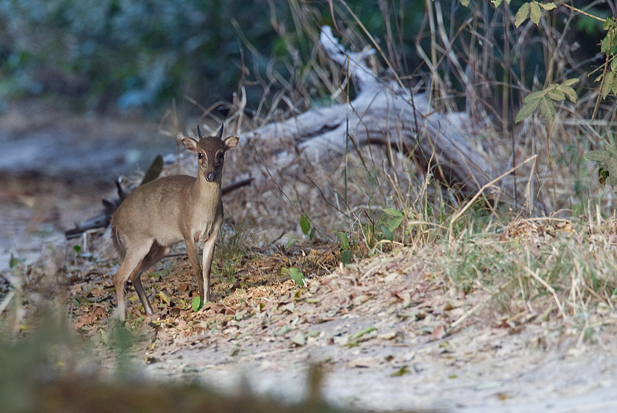
A Maxwell’s Duiker, Philantomba maxwellii, considered to be Least Concern under the terms of the International Union for the Conservation of Nature's Red List of Threatened Species and hunted by poachers in the Kakum Conservation Area of Ghana. Paul Cools/iNaturalist/ICUN Red List.

In January 2013 the patrols arrested one poacher, armed with a shotgun, and in possession of two Maxwell's Duiker, one Lowe's Monkey, and one Spot-nosed Monkey. In February one poacher was arrested, in possession of snares and two Maxwell's Duiker, one Royal Antelope, one Tree Squirrel and a Potto. In march 2013 a single poacher was apprehended, armed with a shotgun and in possession of one Maxwell's Duiker and one Lowe's Monkey. In April 2013 no poachers were arrested.

A Lowe's Monkey, Cercopithecus lowei, in the Mole Game Reserve in Ghana. This species is again considered to be of Least concern under the terms of the ICUN's Red List, and is hunted in the Kakum Conservation Area of Ghana. Peter Strong/Wikimedia Commons.

In May 2013 four poachers were arrested, armed with shotguns and in possession of five Maxwell's Duiker, two Royal Antelope, two Lowe's Monkeys, and one Spot Nosed Monkey. In June no poachers were apprehended again, while in July 2013 three poachers were arrested, in possession of shotguns and having killed two Maxwell's Duiker, one Lowe's Monkey and one Elephant.

African Elephant, Loxodonta africana, in the Kakum National Park. The species is considered to be Vulnerable under the terms of the ICUN's Red List. Kakum National Park.
 
In August 2013 the patrols arrested one poacher, armed with a shotgun and in possession of one Royal Antelope, one Flying Squirrel, one Lowe's Monkey, one Olive Colobus, and one live Pangolin. No poachers were apprehended in September or October 2013, while in November 2013 another single poacher was arrested, this time armed with a shotgun and and in possession of one Maxwell's Duiker, two Lowe's Monkeys and two live Pangolins.

A Long-tailed Pangolin, Uromanis tetradactyla, in the Kakum National Park. One of three Pangolin species in the area, all of which are considered to be Vulnerable under the terms of the ICUN's Red List. Lars Peterson.

During the time of the study 69 animals were recovered by Wildlife Protection Rangers in the Kakum National Park, including 29 Rodents, 19 Antelope, 13 Primates, seven Pangolins, and an Elephant. Of these eight belonged to species considered to be Vulnerable under the terms of the ICUN's Red List of Threatened Species (the Pangolins and the Elephant) one belonged to a species considered to be Near Threatened (the Olive Colebus), while the remainder belonged to species considered to be of Least Concern. This pattern did not vary notably from that in areas where hunting is not illegal.

The favoured weapon of the Poachers was clearly the shotgun, which Wiafe notes is the weapon most conservationists would prefer to see used, as it is a discriminating weapon which allows hunters to only take the animals they want, unlike snares which are more random. This is not always the case in protected reserves, as the sound of shotguns can attract the attention of patrols, however in this instance the hunters reported preferring shotguns as they enable them to target animals in the tree canopy. However the Wildlife Rangers also reported sometimes finding fencing around paths in the reserves, directing animals to snares outside the bounds of the protected area.

See also...

http://sciencythoughts.blogspot.co.uk/2018/03/cheirogaleus-grovesi-new-species-of.htmlhttp://sciencythoughts.blogspot.co.uk/2018/01/calculating-role-of-pleistocene-refugia.html
http://sciencythoughts.blogspot.co.uk/2017/11/image-of-elephant-human-conflict-wins.htmlhttp://sciencythoughts.blogspot.co.uk/2017/11/pongo-tapanuliensis-new-species-of.html
http://sciencythoughts.blogspot.co.uk/2017/10/elephants-kill-four-rohingya-refugees.htmlhttp://sciencythoughts.blogspot.co.uk/2017/10/unsustainable-chocolate-production.html
Follow Sciency Thoughts on Facebook.