Friday, 8 April 2022

Magnitude 6.0 Eathquake to the west of Efate Island, Vanuatu.

The United States Geological Survey recorded a Magnitude 6.0 Earthquake at a depth of 23.6 km, about 54 km to the west of Efate Island, Vanuatu, slightly after 3.05 am local time on Tuesday 5 April 2022 (slightly after 4.05 pm  on Monday 4 April, GMT). There are no reports of any damage or casualties associated with this event, though people reported feeling it on several of Vanuatu's islands. 

 
The approximate location of the 5 April 2022 Vanuatu Earthquake. USGS.

Vanuatu is located on the southwestern fringe of the Pacific Plate, close to its boundary with the Australian Plate, which is being subducted along the New Hebrides Trench, to the west of the islands. The subducting Australian Plate passes under the islands of Vanuatu as it sinks into the Earth, causing Earthquakes as the plates stick together then break apart as the pressure builds up. As the plate sinks further it is partially melted by the heat of the friction combined with that of the Earth's interior. Some of the melted material then rises through the overlying Pacific Plate, fuelling the volcanoes of Vanuatu.

See also...


Follow Sciency Thoughts on Facebook.

Follow Sciency Thoughts on Twitter.


The Cabeço da Amoreira burial: An Early Modern Era West African buried in a Mesolithic shell midden in Portugal.

The Tagus and Sado valleys of central Portugal contain numerous shell middens, dating back to the Late Mesolithic, roughly 6500 to 5000 years ago. As well as depositories for waste shells, these sites were used as burial grounds by the people who made them. A number of these sites were excavated by archaeologists in the 1930s, producing a series of sets of Human remains, buried within the middens without grave goods. One site, Cabeço da Amoreira at Muge in the Tagus Valley yielded an individual noted at the time as being both notably taller and better preserved than others recovered from such sites. More recently, scientists working on a database of Mesolithic European genomes have begun to sequence individuals from these Mesolithic Portuguese sites, including the Cabeço da Amoreira individual, in the process of which they found that this individual was not closely related to other individuals from Mesolithic burials in Portugal, or elsewhere in Europe, but rather appeared to be of African descent.

In a paper published in the Journal of Archaeological Science: Reports on 21 February 2022, Rita Peyroteo-Stjerna of Human Evolution at Uppsala University and the Centro de Arqueologia da Universidade de Lisboa, Luciana Simões, also of Human Evolution at Uppsala University, Ricardo Fernandes of the Department of Archaeology at the Max Planck Institute for the Science of Human History, the School of Archaeology at the University of Oxford, and the Faculty of Arts at Masaryk University, independent researcher Gonçalo Lopes, and Torsten Günther and Mattias Jakobsson, again of Human Evolution at Uppsala University, present the results of the follow up study which used multiple lines of enquiry to determine the origin of the Cabeço da Amoreira individual.

 
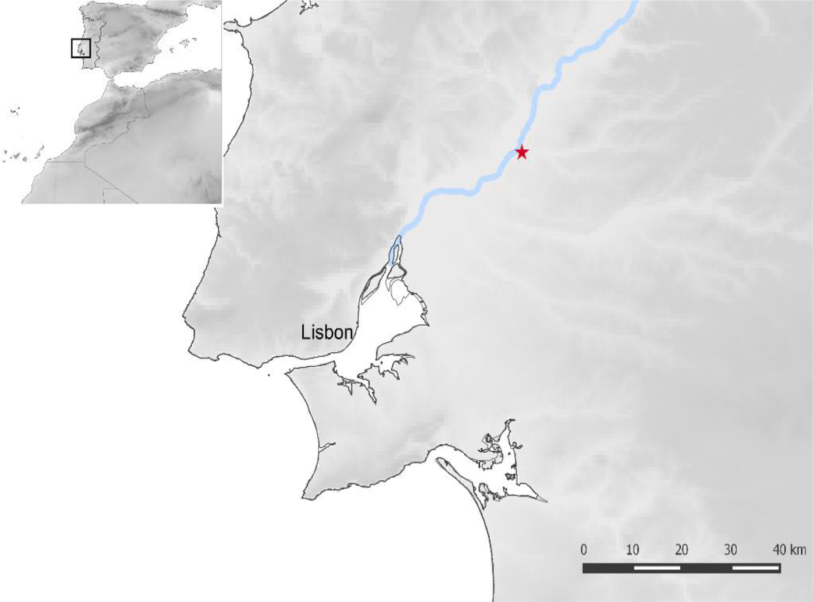
Location of Cabeço da Amoreira shell midden (indicated by the star), Muge, Tagus valley, Portugal. Peyroteo-Stjerna et al. (2022).

Radiocarbon dating of material from the Cabeço da Amoreira site, including bone, charcoal and shells, have produced dates of between 6500 and 5000 BC, consistent with a Mesolithic origin for the site, however, radiocarbon dating of collagen from the individual buried at the site yielded dates between 1529 and 1763 AD, and probably between 1631 and 1793, consistent with an Early Modern origin. 

Relationships between Early Modern Europe and Africa were dominated by the trans-Atlantic slave trade, which saw millions of people taken from Africa and shipped to European colonies in the New World, and to a lesser extent Europe itself. Portugal is estimated to have directly imported 2-3000 African slaves per year between the fifteenth and nineteenth centuries. Most of these remained enslaved their whole lives, though some were freed and able to live relatively independent lives, albeit very much at the bottom of the social scale. 

Because mitochondrial DNA is found in the mitochondria, organelles outside the cell nucleus, it is passed directly from mother to child without being sexually recombined each generation, enabling precise estimations of when individuals shared common ancestors, at least through the female line; this is known as the female haplogroup. It is also possible to trace direct ancestry through the male line, using DNA from the Y chromosome, which is passed directly from father to son without sexual recombination; this is known as the male haplogroup. Since everyone has mitochondria, it is possible to determine the female haplogroup of all Humans, but generally only males have a Y chromosome and can be assigned to a male haplogroup.

Genetic analysis of the Cabeço da Amoreira individual established that he had a Y chromosome, indicating that he was male. It was also possible to determine both his male haplogroup. He was found to belong to the E1b1a male haplogroup, which is the most widespread in sub-Saharan Africa, being commonly found in Nigeria, Congo, Cameroon, Gabon, Guinea-Bissau, and among Bantu-speakers in Southern Africa.

A principle component analysis based upon his entire recoverable genome revealed that Cabeço da Amoreira man showed a greater genomic similarity to West Africans than to other populations, and in particular, to people of Gambian or Mandinka origin. 

 
(A) Principal component analysis. Worldwide modern populations (circles coloured according to continent) and Cabeço da Amoreira man projected as a yellow, red outlined diamond. (B) Geographic distribution of the genetic affinity of the studied individual with modern African populations, measured by outgroup-f₃. The two highest f₃ scores are depicted with diamonds. Peyroteo-Stjerna et al. (2022).

Peyroteo-Stjerna et al. next looked for alleles (gene variants) associated with sub-Saharan populations, finding that Cabeço da Amoreira man had a number of alleles which would further support an African origin, notably the FY*B allele, which is associated with resilience to Malaria, and a number of skin pigmentation alleles, namely MFSD12 rs10424065; DDB1 rs11230664; OCA2 rs1800404; SLC45A2 rs16891982; and HERC2 rs6497271, which are more commonly associated with sub-Saharan African populations than with Europeans (skin pigmentation is complicated, genetically speaking, and it is not possible to directly determine someone's exact skin tone from their genome at the current time, but it is possible to associate allele abundances with specific populations). Cabeço da Amoreira man also lacked the alleles for lactase persistence (i.e. retaining the ability to digest milk into adult life), sugesting that he was lactose intolerant, something more common in Africans than Europeans.

A stable isotope analysis for carbon and oxygen isotopes, based upon bone collagen from Cabeço da Amoreira man, suggested that when he was growing up his diet comprised largely C₄ Plants, supplemented with seafood. A diet of C₄ Plants is not at all typical for Portugal (or elsewhere in Europe) in the Early Modern period, although it would have been common in parts of West Africa, notably the Sahel Region (which reaches the coast in the Senegambia region and southern Mauritania), where the principal crops for the time would have been Sorghum and Millet, both of which are C₄ Plants. Further south, in the West African forest zone, the principal crops were Rice (a C₄ Plant) in the west and a more mixed vegecultural diet (also based around C₄ Plants) in the east. Therefore, the C₄ Plant component of Cabeço da Amoreira man's diet makes it likely that he came from the Sahel region, and the seafood component further ties him to the Senegambia and Mauritania region.

 
Estimated area of origin of Cabeço da Amoreira man (mug019) in West Africa and place of burial in Portugal. Traditional plant food-producing systems in West Africa. Peyroteo-Stjerna et al. (2022).

Around 35 000 slaves were brought to Portugal from Africa between 1514 and 1866. Records of these movements are fairly complete after 1750, but older records are somewhat patchy, making the origin of Cabeço da Amoreira man difficult to reconstruct in this way. However, it is known that slaves were brought to Portugal from predominantly from Guinea-Bissau and The Gambia, with smaller numbers arriving from the Cape Verde islands, Princes Island and São Tomé, Bance Island (Sierra Leone), the Gold Coast (Ghana), Senegal and Whydah (on the coast of modern Benin). 

Most slaves in Portugal during this period would have been baptised as Christians, and buried in Christian burial grounds. However, there are records of slaves being buried in other ways, including by roadsides, in wastelands or in Olive groves. The Church generally kept good records of births, deaths, marriages, and baptisms during this period, for all social classes including slaves, which offered some hope of discovering the identity of Cabeço da Amoreira man. Peyroteo-Stjerna et al. were able to identify two deaths of interest in the Cabeço da Amoreira area in the seventeenth century, the first of an unnamed slave on 5 May 1633, for whom no burial location is listed, and the second of the murder of a man named João at Arneiro da Amoreira on 1 November 1676; João is described as being brown skinned, which may indicate that he was of mixed origins, but he was buried in a churchyard, so presumably was not Cabeço da Amoreira man.

One notable feature of the Cabeço da Amoreira burial is that the body does not appear to have been buried hastily, but rather laying upon a bed of sand which had been used to line the grave, something not seen in Mesolithic shell midden burials (the difference was noted at the time of excavation, but the significance of this, understandably, was not realised).This implies that the burial at this location was planned and carefully executed, rather than being the hurried disposal of the body of a slave or murder victim.

Shell midden burials, both ancient and modern, are known from the Senegambia region, and are still sometimes practiced among Serer fishermen in the Saloum Delta. Here, some families maintain temporary settlements on islands deep within the delta, which are used for four-to-five months each year, when shellfish are harvested. Since these sites are essentially located on shifting sandbanks, the shell middens that build up their form stable hardgrounds, which can be used for purposed such as supporting structures and burying anyone who dies while the temporary villages are in use.

 
Modern cemetery on a shell midden, at Fadiouth in the Saloum Delta, Senegal. Hardy et al. (2015).

This does not unequivocally tie the Cabeço da Amoreira burial to the Senegambia region, but does create a plausible scenario in which members of a community transplanted to Portugal, who had practiced shell midden burials in their homeland, might have chosen to recreate the practice in their new environment.

See also...


Follow Sciency Thoughts on Facebook.

Follow Sciency Thoughts on Twitter.


Tuesday, 5 April 2022

Covidifructus multicarpellatus: A multicarpellate fruit from the Late Cretaceous of South Bohemia.

The earliest Flowering Plants are thought likely to have produced flowers with several carpels (ovule-bearing female reproductive organs) free from each other, a state still seen in Plants such as Lotuses and Roses. However, most modern Flowering Plants have flowers with several fused carpels, typically three in Monocotylodons and two to five in Eudicotids. This is thought to have been a key adaptation in Flowering Plants, allowing more efficient pollination and seed/fruit dispersal, which arose multiple times in different lineages early in the history of the Flowering Plants. Although most modern (and fossil) Flowering Plants have fused carpels, plants with more than five carpels in a single whorl are rare, despite having evolved numerous times in different Plant groups, suggesting the advantages of such an arrangement are limited. Today this condition can be seen in some Water Lilies, Water Plantains, Poppies, and several other lineages. Examples are known in the fossil record as well, including Monetianthus mirus, a Water Lily from the Early Cretaceous of Portugal, Carpestella lacunata, probably a member of an extinct group closely related to Water Lilies, from the Early Cretaceous of North America, and Elsemaria kokubunii, probably a member of the Dilleniaceae, a group of woody shrubs with a largely tropical distribution, from the Late Cretaceous of Japan.

In a paper published in the journal Palaeontologica Electronica on 14 January 2022, Zuzana Heřmanová of the National Museum in Prague, Jana Čepičková of the Institute of Geology and Palaeontology at Charles University, Jiří Kvaček, also of the National Museum in Prague, and Maria von Balthazar and Jürg Schönenberger of the Department of Botany and Biodiversity Research at the University of Vienna, describe a new multicarpellate fruit from the Late Cretaceous of South Bohemia.

The specimen comes from the Klikov Formation (Late Turonian–Santonian) at the Zliv-Řídká Blana Quarry, a typical Laurasian Late Cretaceous site which has produced fossils of Plant reproductive organs, leaves, and wood belonging to the Normapolles (an extinct group related to Oaks and Beeches), Proteales (Proteas), Laurales (Laurels), Ericales (Heathers), as well as Insects and the coprolites of larger Animals. It is a charcoalified and 3-dimensionally preserved specimen representing a 10-carpellate syncarpous gynoecium.

The new species is named Covidifructus multicarpellatus, where 'Covidifructus' refers to the Covid-19 pandemic, which provided the authors with the time to work on the project, and 'multicarpellatus' refers to the multicarpellate nature of the specimen. The specimen has 10 carpels in radial symmetry, each of which has a single locule (cavity) holding a large oblong ovule or seed. Lines of dehiscence (i.e. lines along which the body would be expected to split open) are located on the median-dorsal side of each carpel.

 
Covidifructus multicarpellatus; specimen No. NMP F3200; scale bars equal 100 μm in all figures. (A) Small premature capsular fruit in lateral view, semi-globose in overall shape; SEM. (B) Fruit seen in apical view; note preformed dorsal lines of fruit dehiscence; SEM. (C) Close-up of fruit apex showing styles and stigmatic areas (asterisks); note irregular closure of ovary in the very centre; SEM. (D) MicroCT volume rendering, lateral view, showing 10 elongate seeds (green), one seed per carpel. (E) MicroCT volume rendering, apical view, showing regular arrangement of carpels and seeds. (F) Detail of central ovary closure (dashed line); note that some of the carpel flanks (arrowheads) do not extend to the very centre of the closure zone; SEM. Heřmanová et al. (2022).

Heřmanová et al. compared Covidifructus multicarpellatus to a range of extant and fossil multicarpellate fruit-bearing Plants. It does not appear to be closely related to either Monetianthus mirus or Carpestella lacunata. It does appear to resemble illustrations of Elsemaria kokubunii somewhat, although Heřmanová et al. disagree with the original description of this fossil, a single permineralized fruit from the Late Cretaceous of Japan, given by Harufumi Nishida in 1994. If Heřmanová et al.'s interpretation of that fossil is correct, then Covidifructus multicarpellatus and Elsemaria kokubuniii are likely to be related, and both to be members of the Dilleniaceae, but re-examination of the original material of Elsemaria kokubuniii would be needed before this can be confirmed.

See also...


Online courses in Palaeontology. 

Follow Sciency Thoughts on Facebook.

Follow Sciency Thoughts on Twitter.


Sunday, 3 April 2022

Lassa Fever reported in Togo, West Africa.

The World Health Organisation was notified of an outbreak of Lassa fever in Togo following the confirmation of a case on 26 February 2022. Active case finding, and contact tracing has been conducted following the confirmation. The risk of transmission for this outbreak is assessed as low at the national and regional level given the experience of national authorities with past outbreaks and the cross-border communication with neighbouring countries.

On 26 February 2022, the national authorities in Togo notified the World Health Organization of an outbreak of Lassa fever after a 35-year-old female patient, from the town of Takpamba in the Oti-South District of the Savanes Region was laboratory confirmed as having been infected with the disease.  The town borders Ghana and is located 96 kilometres from Dapaong, the capital city of the Savanes Region. The patient had previously lived in a village in the Save Commune in Benin, four kilometres from the Nigerian border, and arrived in Takpamba on 4 February prior to the onset of symptoms.  

On 11 February, the patient developed symptoms including fever, abdominal pain and cough, and consulted the local health care facility on 14 February.  Following three days of oral treatment and no improvement, the case was taken to another health centre where she was hospitalised for 24 hours and was later referred to a hospital where she was managed as an outpatient. On 22 February, the patient returned to the previously visited hospital following persistence of symptoms as well as having developed vomiting and bloody diarrhoea. As a result of her clinical picture, Lassa Fever was suspected, and the individual was isolated and notified to the health authorities.  A sample was taken for laboratory analysis at the National Institute of Hygiene, Togo, and tested positive for Lassa Fever on 26 February. The patient died the same day, and a safe and dignified burial was performed.

A total of 26 contacts were identified from two health districts of the Savanes Region, including 10 health care workers, one of whom was symptomatic and isolated. The symptomatic health care worker was exposed through direct contact with the case but upon testing was negative for Lassa Fever.  As of 23 March, all contacts have completed the follow-up period, and none developed Lassa Fever. No outbreak has been reported from Benin or Ghana associated with this reported outbreak in Togo, however, there is an ongoing outbreak in Nigeria.

 
Confirmed case of Lassa fever in Togo, bordering Ghana and Benin. World Health Organization.

Lassa fever is caused by the Lassa Virus, a member of the Arenavirida Virus family, single stranded RNA Viruses which cause a range of illnesses in animals and Humans, including Lujo Fever (a haemorrhagic disease endemic to southern Africa), Lymphocytic Choriomeningitis (a form of Meningitis) and Whitewater Arroyo Fever (a haemorrhagic disease endemic to the southwestern United States). It is an acute Viral haemorrhagic fever that is primarily transmitted to Humans through direct or indirect contact with food or household items contaminated with the urine or faeces of infected Rodents of the genus Mastomys. Though to a lesser extent, person-to-person infections can occur during the acute febrile phase through virus particles present in blood and bodily fluids of the infected person. This includes transmission in the health care facility and laboratory; thus, health care workers should be among the risk groups targeted for prevention. Overall, the case fatality ratio is around 15% among hospitalized patients with severe presentation. 

The incubation period of Lassa Fever ranges from 6 to 21 days. The onset of the disease, when symptomatic, is gradual, starting with fever, general weakness, and malaise. After a few days, headache, sore throat, muscle pain, chest pain, nausea, vomiting, diarrhoea, cough, and abdominal pain may follow. In severe cases, facial swelling, fluid in the lung cavity, bleeding from the mouth, nose, vagina or gastrointestinal tract and low blood pressure may develop.  

The antiviral drug, Ribavirin has been given as treatment for Lassa Fever in recent years, however, recent systematic reviews showed there is no strong evidence about the efficacy of Ribavirin treatment on the outcome of patients with Lassa Fever as well as optimal dosing regimens, highlighting the need for further research, particularly in the form of randomized clinical trials. Therefore, if the decision is to use Ribavirin, it should be made under clinical trial protocol to evaluate safety and efficacy of the drug and the dosage. There is currently no approved vaccine for Lassa Fever, however, optimized supportive care provided as early as possible with rehydration and symptomatic treatment can increase the chance of survival.

Lassa Fever is endemic in West Africa with cases frequently reported from Benin, Ghana, Guinea, Liberia, Mali, Nigeria and Sierra Leone. Togo is affected to a lesser extent, however, since 2016, outbreaks and sporadic cases have been reported in the country every few years.  Notable Lassa Fever outbreaks have occurred in Togo in 2016, 2017, and the most recent was in January 2019 when two imported cases from Nigeria were reported in the Central and Kara regions of Togo. No further cases were identified, and the Ministry of Health declared an end to the outbreak in February 2019.  

Outbreaks of Lassa fever in Togo have involved importation and exportation of cases at various times to nearby countries requiring the need for cross-border communication. In both endemic regions and areas with sporadic cases in West Africa, the majority of cases are reported during the dry season from December to April.

See also...


Follow Sciency Thoughts on Facebook.

Follow Sciency Thoughts on Twitter. 


Benthodytes jiaolongi: A new species of deep-sea Sea Cucumber from the Western Pacific.

Sea Cucumbers (Holothuroidea) are a class of Echinoderms that have become elongated and worm-like, effectively becoming secondarily bilaterally symmetrical. Like all Echinoderms they have a calcareous exoskeleton, but this is greatly reduced, typically only occurring as ossicles within the epidermis. The muscle structure of Sea Cucumbers is instead supported by a layer of modified collagen that can be stiffened or relaxed at will, allowing for a more flexible body than that of other Echinoderms. The Family Psychropotidae currently comprises 37 species of deep-sea Sea Cucumbers, which are elongated and flattened to facilitate swiming, and typically have a large tail-appendage of uncertain purpose. Although the Psychropotidae were first discovered during the H.M.S. Challenger Expedition of 1872–1876, the group are relatively understudied, and phylogenetic relationships within the family poorly understood.

In a paper published in the journal ZooKeys on 9 March 2022, Chuan Yu of the School of Oceanography at Shanghai Jiao Tong University, and the Key Laboratory of Marine Ecosystem Dynamics at the Second Institute of Oceanography of the Ministry of Natural Resources, Dongsheng Zhang, also of the School of Oceanography at Shanghai Jiao Tong University, and the Key Laboratory of Marine Ecosystem Dynamics at the Second Institute of Oceanography of the Ministry of Natural Resources, and of the Southern Marine Science and Engineering Guangdong Laboratory, Ruiyan Zhang, again of the School of Oceanography at Shanghai Jiao Tong University, and Chunsheng Wang, once again of the School of Oceanography at Shanghai Jiao Tong University, and the Key Laboratory of Marine Ecosystem Dynamics at the Second Institute of Oceanography of the Ministry of Natural Resources, the Southern Marine Science and Engineering Guangdong Laboratory, and of the State Key Laboratory of Satellite Ocean Environment Dynamics of the Ministry of Natural Resources, describe a new species of Psychropotid Sea Cucumber from the Western Pacific.

The new species is described from four specimens collected from the Weijia Guyot and Kyushu-Palau Ridge by the Jiaolong Human Operated Vehicle. The new species is placed in the genus Benthodytes , and given the specific name jiaolongi, in reference to the vehicle used to recover the specimens.

 
Benthodytes jiaolongi specimen (RSIO6017101, paratype) in situ on the Kyushu-Palau Ridge. Yu et al. (2022).

Benthodytes jiaolongi is a red-to-violet elongated and subcylindrical Sea Cucumber reaching about 25 cm in length. It has eighteen tentacles surrounding its mouth, and two rows of midventral tube feet. 

Benthodytes jiaolongi. (A) Dorsal view, (B) ventral view. Yu et al. (2022).

See also...


Follow Sciency Thoughts on Facebook.

Follow Sciency Thoughts on Twitter. 


Understanding the unexpected volcanoes of Pluto.

Pluto is the largest body in the Kuiper Belt, with a diameter of 2377 km and a density which suggests a structure comprising about 300 km of water-rich ice overlaying a rocky core. It is not predicted to have high levels of internal radiogenic heating, and, while it is thought that the moon Charon was formed in a collision event, any residual heating from this event, or subsequent tidal interactions, should have dissipated billions of years ago. Surface temperatures on Pluto range between 35 and 60K (between -238 and -213°C). The surface pressure on Pluto is about 10 μbar, precluding the existence of any form of liquid there. At the temperatures and pressures found on the surface of Pluto water should be an immobile bedrock. Adding sufficient amounts of ammonia to water can lower its freezing point by about 100 degrees, and other substances could conceivably lower it slightly further, but depressing the freezing point of water enough for it to retain any fluidity on the surface of Pluto is highly unlikely. Nevertheless, when the New Horizons space probe visited the dwarf planet in 2015, it found abundant signs of resurfacing, which are difficult to explain without the presence of liquid water beneath the surface of Pluto.

In a paper published in the journal Nature Communications on 29 March 2021, a team of scientists led by Kelsi Singer of the Southwest Research Institute discuss the possibility of cryovolcanism (ice volcanoes) as an explanation for the observed features on the surface of Pluto.

Singer et al. examine an area to the southwest of the Sputnik Planitia ice sheet (an ancient impact basin with a diameter of about 1000 km), which they view as a possible volcanic terrain. The most prominent features of this region are a series of large rises or mounds of material separated by broad depressions, the two largest of which form annular features with deep central depressions, and are named Wright Mons and Picard Mons. Wright Mons stands roughly 4-5 km high, and has a diameter of about 150 km, giving it a volume of roughly 24 000 km³, while Picard Mons appears to be about 7 km high, and to have a diameter of about 225 km.

 
Panchromatic basemap mosaic of the putative cryovolcanic terrains; dashed red curve indicates the transition from directly sunlit terrain to haze-lit terrain. Simple cylindrical projection. Image shown with north up, and the lighting direction is indicated here with the large arrow at the upper left. Singer et al. (2022).

Wright Mons is surrounded, and partially covered, by a hummocky terrain, which has a typical wavelength of 6-12 km, but reaches up to 20 km between hummocks in places. The hummocks are generally interconnected rather than singular, and have flattened or rounded tops. In the images the northern flank of Wright Mons, and the plain to the north of the mountain, appear to be smoother and less hummocky, but Singer et al. suggest that this is probably an artifact of the lighting direction. The hummocks appear to have no preferred direction with regard to the summit, and closer examination shows smaller structures, such as boulders, blocks, slabs, and ridges, with scales of 1-2 km, superimposed on top of the hummocks.

 
Features of Wright Mons and the surrounding terrain. (a) Wright Mons region with features labelled, (b) high-resolution topography for Wright Mons, (c) zoom of region with smaller dome named Coleman Mons (label 'D'), undulating, hummocky terrain on the flanks of Wright Mons and the superposed smaller-scale (1–2 km) ridges or boulders, (d) topographic profile of Wright Mons and adjacent rise as shown by the line A to A’ in panel (a). All images are from the New Horizons observations on a simple cylindrical projection. The large arrow in the upper left of panel a indicates the direction of incoming sunlight. Figure shown with north up. Singer et al. (2022).

The slopes of the flanks of Wright Mons average about 3-5°, but reach 10° in places. The mountain has a central depression roughly 40-50 km across and about 4 km deep (i.e. taking it down to the level of the surrounding terrain). The central depression of Picard Mons appears to be larger still, with a more u-shaped profile. The structure of these bodies is unlike anything seen in terrestrial or Martian volcanoes, with the central caldera(?) taking up a third of the structure's area and being as deep as the mountain is tall. The inner slopes of the crater appear to have the same hummocky profile as the outer slopes, with no collapse terraces, or similar structures, as might be expected on a volcano in the Inner Solar System. The northern and southern faces of Wright Mons, and the nearby ridge of the Medial Montes all appear to have similar profiles, with a steeper northern face and a more shallowly inclined southern face, both of which are covered by hummocks.

 If the interior depressions of Wright and Picard montes are collapse structures, formed within formerly dome-shaped structures, then they would represent a loss of about half the mountains' total masses, which seems highly implausible. 

 
Topographic profile comparison. (a) Mauna Loa (subaerial portion only) compared with Wright Mons (roughly N-S through the feature), upper panel is without vertical exaggeration, and lower panel is shown at 10× vertical exaggeration. Mauna Lau continues for approximately 6 km below the ocean surface. This figure illustrates how Wright Mons is very dissimilar to Mauna Loa and that if Wright was originally more similar to a shield volcano it would have had to have lost more than 50% of its volume from the central region in order to attain its current appearance. (b) Martian shield volcanos from the Tharsis region provide additional examples of large volcanos, some with more advanced caldera collapse. Several of these also show signs of later embayment, thus they also may not represent the full original height of the features. The more typical collapse terraces can be seen in the Martian calderas. Note that none of these examples are scaled for gravity, they are shown at their original scales. Singer et al. (2022).

A few other depressions of varying size are scattered across the area around Wright and Picard montes. These are generally not circular in shape, which rules out an impact origin. Some of these structures may be related to collapse at fault faces, while others might be depressions between areas of uplift.

No vents or fractures from which effusive material might escape can be seen in this landscape, not any sign of flow through which the presence of such structure might be inferred, although this might be an artefact of the resolution of the images (234–315 m per pixel), which prevents the detection of small structures. Nor are there any signs of explosive eruptions, such as fall deposit patterns (either radial or directional), or steeper cones. The extent of this terrain is unclear, as it continues southward until it disappears within a low-light haze. The absence of any cratering on or around Wright Mons gives it a maximum age of 1-2 billion years, and potentially considerably younger.

Methane, nitrogen, and water ice have all been observed on the surface of Pluto, in high-volume, concentrated deposits, so Singer et al. consider whether these might make up the structures of Wright and Picard montes, and the surrounding terrain. Data provided by the Linear Etalon Imaging Spectral Array instrument on New Horizons suggests that nitrogen- and methane-rich complexes of nitrogen, methane, and carbon monoxide cover much of the surface of Pluto. These are likely to sublimate and redeposit on a seasonal cycle (which on Pluto implies a 248 Earth year cycle), or a multi-million-year cycle determined by obliquity/precession cycles. In darker areas with low albedos these volatiles are either not being deposited, or not being retained, with the upshot that these areas are dominated by the non-volatile water ice 'bedrock'. Such areas include the dark equatorial band of Pluto, as well as the terrain around Wright and Picard montes. In this later area, deeper areas are dark, implying water ice, whereas higher elevations are more reddish, suggesting the presence of methane ice. This is probably a thin layer of snow, with the bulk of the structures composed of water ice. The area shows a very different topographic profile to the 'bladed terrain' found at high altitudes close to Pluto's equator, which is thought to be formed by the condensation and sublimation of thick methane deposits.

 
Comparison of Bladed Terrain and Wright Mons region. (a) The bladed terrain deposits form one of the highest elevation areas on Pluto (on the far eastern side of the hemisphere observed by New Horizons during closest approach) and are hypothesized to be a sprawling, concentrated deposit of methane ice, with the bladed texture forming due to sublimation of methane. It may also exist in large areas on the 'ar side' of Pluto that was only observed at low resolution by New Horizons. (b) Although Wright Mons has several different scales and styles of textures, it is not covered by the distinctive blades that characterize the bladed terrain. The longitude and latitude extents are as follows: panels (a) approximately 220–243°E and approximately 10–26°N; panel (b) approximately 165–175°E and approximately 19–26°S. The large arrows in the upper left indicate the approximate direction of the incoming light. Singer et al. (2022).

Patches of nitrogen ice can also be seen in the area around Wright and Picard montes, both in thin layers on the peaks, similar to the distribution of methane, and in depressions where it has apparently pooled. Although conditions on Pluto are cold enough to make water ice an immobile bedrock, nitrogen here is much closer to its melting point, and therefore likely to be capable of some sort of glacier-like plastic flow, which means that nitrogen ice is unlikely to be able to form tall topographic features.

 
Colour information for the Wright Mons region. Darker/lower albedo, redder patches exist primarily on north-facing slopes but there are also more subtle differences in albedo and redness across the region. The region labelled 'A' represents a redder unit transition to less red units at lower elevation (described in the text and methods). The longitude and latitude extents of the image are approximately 160–182°E and 13–31°S. Singer et al. (2022).

For these reasons, Singer et al. assume that the bulk of the Wright and Picard montes structures, and the surrounding topographic features, are composed of water ice, although these is a potential for other materials to have played a role in their formation and evolution. Notably, ammonia has been detected in areas in Pluto's Northern Hemisphere where cryofluids are thought to have erupted through extensional fractures. No ammonia has been detected in the study area, but its presence could potentially be masked by the presence of methane ice. There are also some darker areas on some north-facing slopes, which may indicate the presence of tholins (disordered and insoluble carbon-rich macromolecular materials).

The ices of the Wright Mons region have a slightly reddish tinge to them, indicating the presence of methane, while the terrain to the north is significantly redder, and that to the west is much less red. This may indicate that these regions are of different ages, having been emplaced at different times, from varying source reservoirs, although their precise age-relationship is impossible to determine.

Singer et al. note a number of features which they  believe indicate suggest the study area was not formed by the erosion of an older, elevated terrain. The area around Wright and Picard montes represents a large area of terrain lacking in craters, suggesting that the area was resurfaced in a single or series of events rather than as a consequence of gradual evolution. The distinct hummocky pattern seen in this terrain covers both the plains and the raised topographic features, and is unlike anything seen elsewhere on Pluto. The raised topographic features of the region are variable in elevation, whereas topographic features made from similar materials and exposed to the same conditions tend to erode down to similar heights.

Examination of the available data leads Singer et al. to conclude that Wright Mons, and probably also Picard Mons, formed by the merging of multiple separate rises into a single structure, and that it shares a structure essentially similar to the other topographic features of the area. They note that a smaller dome-like feature, named Coleman Mons, may provide an example of the emplacement of how such structures form. This dome is about 25 km in diameter and 1.5 km high, a structure which could be achieved by water or water-ammonia ice being deposited around a central vent, but would be beyond the ductile strength of softer ices such as nitrogen or methane.

Smaller dome-like feature named Coleman mons. (a) Topography overlain on base image of feature, (b) base image alone, (c) topography alone, (d) perspective view of dome and pit with no vertical exaggeration, (e) view inside the pit, (f) topographic profiles as shown in panels (a)-(c) with 3× vertical exaggeration. Singer et al. (2022).

The hummocky profile of the flanks of Wright Mons and the surrounding terrain suggests some form of viscous flow is occurring. Singer et al. suggest three different possibilities for the formation of these features, namely; the (1) creation of individual small volcanic domes, the (2) viscous extrusion of rapidly cooled lavas analogous to pillow lavas, or the (3) compression of viscous material with a frozen skin analogous to pahoehoe, viscous pressure ridges, or funiscular terrain on Enceladus.

The formation of ridges from pillow-lava like extrusions would require lava ice to be extruded at similar rates and for similar durations, both on the flanks of Wright Mons and on the surrounding plains. Such an even rate of extrusion across a varied terrain seems highly unlikely, and is at odds with observations of volcano behaviour both on Earth and elsewhere in the Solar System. It is possible that the hummocks were formed first, and then uplifted, but this would require an implausibly large mass of material being emplaced from below. Likewise, if the hummocks are contractional or compressional features, then this would imply a high-viscosity layer 8-13 km thick, which is in itself implausible, as well as a force capable of compressing such a layer, for which no obvious cause exists.

In addition, the extrusion of material to the surface to form any of these features would require a system of deep fractures through which the material could escape. Such structures have been seen elsewhere on the surface of Pluto, but not within the subject area, with the only possible fractures being along the large scarp which separates the Wright region from the plateau to the west, and another possible scarp further to the northwest, although other fractures could be hidden beneath extruded material on the surface.

None of the conventional models used to explain the emplacement of volcanic terrains on Earth and other Solar System bodies examined to date appears to fit well with the observed features on Pluto. Furthermore, the features of the area around Wright Mons appear to be quite different from anything seen elsewhere in the Solar System. No obvious vent regions can be seen, and though the surface does appear to be subject to viscous flow, no indication of directionality can be observed, making it difficult to explain the formation of the topology of the region. However, the constructs are compatible with a cryovolcanic origin, fuelled from multiple subsurface sources where the sources are below the constructs. 

The low surface temperature on Pluto, combined with the low predicted heat flux within the Dwarf Planet's interior, makes it very hard to account for the mobilization of subsurface fluid comprised largely of water, but the relative youth of the terrain suggests that a heat-source must be available. While in itself apparently unlikely, such an unexplained heat-source is would help to explain other areas of Pluto with young surfaces comprised of volatile ices, such as Sputnik Planitia.

See also...


Follow Sciency Thoughts on Facebook.

Follow Sciency Thoughts on Twitter. 


Friday, 1 April 2022

Epidendrum alejandrinae: A new species of Orchid from the high Andean forests of central Peru.

The tropical forests of the high Andes form one of the world's biodiversity hotspots, with the forests located in the eastern cordillera of the Peruvian Andes being particularly rich in endemic species. These unique ecosystems are threatened by Human activities such as agriculture and mining, and are considered to be particularly at risk from climate change. This is particularly true of high-altitude forests dominated by trees and shrubs of the genera Polylepis, Gynoxys, and Escallonia, which are noted for their high biodiversity but which have become highly fragmented.

The Huancavelica region is considered to be poorly explored, botanically speaking, but is considered to be a hotspot for Orchid diversity, with an estimated 200 species within the 50 km² of the Amaru-Huachocolpa-Chihuana Cloud Forest Regional Conservation Area. Epidendroid Orchids, Epidendroideae, are the largest subfamily of Orchids, with over 15 000 described species, more than all other Orchid groups combined. The majority of these species are epiphytic (live on other plants, typically in the canopy of rainforest trees), though terrestrial forms are known. The group is found across the globe, with the exception of the polar regions, the deserts of Africa, Arabia and Australia, and the southern part of South America. The genus Epidendrum, which gives its name to the group, is one of the most speciose Orchid genera, with an estimated 480 described species in Peru alone, found at altitudes ranging from sealevel to 4200 m.

In a paper published in the journal Phytotaxa on 29 March 2022, Harold Rusbelth Quispe-Melgar of the Programa de Investigación de Ecología y Biodiversidad at Asociación ANDINUS, and the Universidad Continental, Yashira Stefani Llacua-Tineo of the Facultad de Ciencias Forestales y del Ambiente at the Universidad Nacional del Centro del Perú, Fressia Nathalie Ames-Martínez, also of the Programa de Investigación de Ecología y Biodiversidad at Asociación ANDINUS, and the Universidad Continental, David Huayta, also of the Facultad de Ciencias Forestales y del Ambiente at the Universidad Nacional del Centro del Perú, Katherine Lucero Lagones Poma of the Facultad de Ciencias Forestales at the Universidad Nacional Agraria La Molina, and Eric Hágsater of Herbario AMO, describe a new species of Epidendrum from Peru, in a high Andean forest dominated by trees of the genus Polylepis (a type of Rosid reaching 15-20 m tall, found at mid-high altitudes in the tropical Andes) in the Huancavelica region of Peru.

The new species is named Epidendrum alejandrinae, in honour of the late Alejandrina Melgar Sotomayor (1957-2020), mother of Harold Rusbelth Quispe-Melgar, for her great passion for plants and their flowers. It is described from a single specimen found growing as an epiphyte on a tree of the genus Gynoxys (a type of Asterid widely distributed in South America) at an altitude of 3900 m, in an area of woodland surrounded by a matrix of grassland, near the Judas lagoon, in the middle Mantaro river basin, approximately 20 km from the Amaru-Huachocolpa-Chihuana Cloud Forest RCA.

 
Epidendrum alejandrinae. (A), (B) Habit and complete plant. (C). Flowers. (D), (E) Habitat. Katherine Lucero Lagones Poma & Harold Rusbelth Quispe-Melgar in Quispe-Melgar et al. (2022).

Epidendrum alejandrinae is an epiphytic Orchid, forming clusters of pendant herbaceous Plants, growing from short, rhizomatous roots. The whole plant has a length of about 30 cm. Leaves are lance-shaped, green, 8-12 cm long and 1-1.6 cm wide. Flowers are green, and born in clusters of 15-25, of which at most about 10 will be open at any one time. These are born on bracts 8-10 mm long, with the whole inflorescence being roughly 8-12.5 cm long. Flowering has been observed in August.

See also...


Follow Sciency Thoughts on Facebook.

Follow Sciency Thoughts on Twitter.