Friday, 31 August 2012

New species of Treesnakes from the Comoras.

The Tree Snakes of the Comoros Islands have traditionally been clasified as being members of a single species, Lycodryas sanctijohannis, or the Saint John's Treesnake, despite considerable differences between the Snakes on different Islands.

In a paper published in the journal PLoS One on 24 August 2012, Oliver Hawlitschek of the Zoologische Staatssammlung Munchen, Zoltan Nagy of the Joint Experimental Molecular Unit at the Royal Belgian Institute of Natural Sciences, and Frank Glaw, also of the Zoologische Staatssammlung Munchen, redescribe the Treesnakes of the Comoros, coming to the conclusion that there are in fact two species of snakes in the islands, each of which should be subdivided into two subspecies, and none of which should be described as Lycodryas sanctijohannis.

The generic name Lycodryas is used for Treesnakes from the islands of the southwest Indian Ocean. The species sanctijohannis was descibed in 1879, based upon a specimen from Mayote Island, however Hawlitschek et al. discovered that a specimen in the British Museum of Natural History described in 1858 as Dipsadoboa maculata, and misidentified as coming from Central America, was in fact a Treesnake from Anjouan, and belonged to the same species as the specimen described as Lycodryas sanctijohannis. Under the complex and somewhat legalistic rules of Taxonomy, the earliest name given to a species is presumed to have precedence, even if the description is very poor. The Mayote Treesnake clearly does not belong in the genus Disadoboa, a group of New World Treesnakes only distantly related to the Snakes of the Comoros, but the specific name maculata is still the earliest name given to a Mayote Treesnake, so the correct name from these snakes should be Lycodryus maculata.

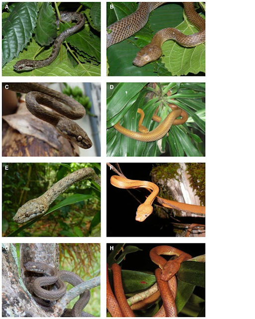
Hawlitschek et al. concluded that the Treesnakes of Mayote and Anjouan belonged to the same species, but were sufficiently different both genetically and morphologically to justify their placement in different subspecies. The Snakes of Anjouan are therefore described as Lycodryas maculata maculata, and the Snakes of Mayote as Lycodryas maculata comorensis. The Snakes of Grand Comoro and Moheli were judged to be sufficiently diffrent to be placed in a different species, named Lycodryus cococola, from Cocos (Coconut) and Cola (Inhabiting), making this the Coconut Treesnake (although the pun probably was intended). Snakes from Grand Comoro are described as Lycodryus cococola cococola and those from Moheli as Lycodrus cococola innocens, meaning inocent; the inhabitants of Moheli being particularly affraid of the snake, and prones to persecuting it, despite the snake being harmless and inoffensive.

Map showing this distribution of Treesnakes in the Comoros. Hawlitschek et al. (2012).

Treesnakes of the Comoros. (A) Male Lycodrus maculata maculata from Anjouan. (B) Female Lycodrus maculata maculata from Anjouan. (C) Male Lycodryus maculata comorens from Mayote. (D) Female Lycodryus maculata comorens from Mayote. (E) Male Lycodrus cococola innocens from Mohile. (F) Female Lycodrus cococola innocens from Mohile. (G) Male Lycodrus cococola cococola from Grand Comoro. (H) Female Lycodrus cococola cococola from Grand Comoro. Hawlitschek et al. (2012).


Massive Earthquake to the east of the Philippines.

On Friday 31 August 2012, slightly after 8.45 pm local time (slightly after 12.45 pm, GMT), the United States Geological Survey recorded an Earthquake roughly 100 km east of Samar Island in the Philippines as measuring 7.6 on the Richter Scale, at a depth of 34.9 km. This is an extremely large quake and is likely to cause considerable problems throughout the Philippines, and potentially neighbouring countries. No reports of any damage or casualties have emerged yet, but the USGS estimate such a quake in this location will have a 35% chance of causing at least one fatality. The NOAA Tsunami Centre issued a tsunami alert for the Philippines, Japan, Indonesia, Taiwan, Papua New Guinea, Hawaii,Guam, Yap and the Northern Mariana Islands, though this has now been lifted for some of these areas.

Map showing the areas that suffered the worst shaking. Areas within the greenish circle are likely to have suffered damage to buildings. USGS.

The geology of the Philippines is complex, with the majority of the islands located on the east of the Sunda Plate. To the east of this lies the Philippine Sea plate, which is being subducted beneath the Sunda Plate; further east, in the Mariana Islands, the Pacific  Plate is being subducted beneath the Philippine Sea Plate. 

The 31 August 2012 quake appears to have happened on the Philippine Trench, where the Philippine Sea Plate is being subducted beneath the Sunda Plate. Quakes on such margins are not uncommon, as tectonic plates do not sink smoothly past one-another, but rather stick then break apart. This presents a high risk of tsunami generation on subductive margins, as the overlying plate can stick to the underlying plate and be drawn back like a bow-string, until the pressure causes the rocks to rift sharply, and the plate margin snaps back suddenly.

Cartoon animation showing how a tsunami can be genrated on a subduction zone. EarthScope.

Follow Sciency Thoughts on Facebook.
 

Large Earthquake near Jan Mayen Island.

On Thursday 30 August, slightly before 1.45 pm local time (which is the same as GMT), the United States Geological Survey recorded an Earthquake measuring 6.8 on the Richter Scale at a depth of 9.9 km, on the Mid-Atlantic Ridge, roughly 400 km east of Greenland. This is a large Earthquake and could cause considerable problems in an inhabited area, though it is unlikely to have done so in the remote North Atlantic, where the only inhabited place likely to have felt shaking would be Jan Mayen Island, 100 km southeast of the quake's center, where the Norwegian Armed Forces and the Norwegian Meteorological Institute both maintain bases, the island's population occasionally rising as high as 35. This quake was followed after about eight minutes by another quake roughly 5 km southeast of Jan Mayen, this time measuring 5.2 on the Richter Scale, at a depth of 12.3 km.

Map showing the locations of the first (A) and second (B) quakes on 30 August 2012. Google Maps.

The Mid-Atlantic Ridge is a divergent plate margin running the length of the Atlantic from north to south, and separating North and South America to the west from Eurasia and Africa to the east. The Atlantic is spreading at an average rate of 25 mm per year, with new seafloor being produced along the rift volcanically, i.e. by basaltic magma erupting from below. In places this produces volcanic activity above the waves, in the Azores, on Iceland and on Jan Mayen Island itself, where the Beerenberg Volcano is the most northerly active volcano on the planet.


Follow Sciency Thoughts on Facebook.
Two Earthquakes beneath the English Channel.


On Tuesday 28 August 2012 a few seconds before 5.25 pm British Summertime (a few seconds before 4.25 pm, GMT) the British Geological Survey recorded an Earth tremmor beneath the English Channel, roughly 40 km northeast of Dieppe, or 100 km south of Folkestone, at a depth of 10 km and measuring 2.3 on the Richter Scale. On Wednesday 29 August, slightly after 1.10 pm British Summertime (slightly after 12.10 pm, GMT) the BGS recorded a second quake, this one roughly 85 km north of Dieppe, at a depth of 10 km and measuring 2.2 on the Richter Scale. None of these events is likely to have caused any damage or injuries, and, since they occured a significant distance offshore, it is likely that nobody noticed them occuring at all.

The location of the 28 August Earthquake. BGS.

This brings the total number of quakes recorded beneath the Channel this week to three; a quake was recorded off the Dorset Coast on Sunday 26 August. It is possible that these events are connected, though it will probably never be possible to tell, as too few quakes occur beneath the Channel for geologists to build up a very detailed understanding of the tectonic stresses there.

The Channel region is subject to tectonic stresses from a number of different sources, and most quakes are probably the result of a combination of more than one of these. Europe is being pushed to the east by the expansion of the Atlantic Ocean, and to the north by the impact of Africa from the south. The Channel is also affected by lesser spreading centers beneath the North Sea, the Rhine Valley and the Bay of Biscay. Finally much of northern and upland Europe was covered by thick glacial ice until about 10 000 years ago, pushing the rocks of the lithosphere down into the underlying mantle. This ice is now gone, and the rocks are slowly sprining back up again, causing the occasional Earthquake in the process.

Thursday, 30 August 2012

New species of Mold found growing on Brazil Nuts in the Amazon Basin.

Molds of the genus Aspergilus are considered major economic pests due to their production of aflatoxins, highly carcininogenic compounds that can cause liver cancers in humans and animals. Several hundred species have been described since the genus was first described in 1725, and there are probably far more undescribed species, since these Molds typically only come to the attention of scientists when they infect commercial crops.

In a paper published in the journal PLoS One on 27 August 2012, A team of scientists led by Marta Taniwaki of the Centro de Ciencia e Qualidade de Alimentos at the Instituto de Tecnologia de Alimentos in Sao Paulo, Brazil announce the discovery of a new species of Aspergilus Mold found growing on Briazil Nuts in the Amazon Basin.

The new species is named Aspergillus bertholletius, as it was found growing exclusively on Brazil Nut trees (Bertholletia excelsa), and in soil close to the trees. It was described as a new species based upon gene sequancing and the shape of colonies growing in petri-dishes.

(a) Colonies of Aspergillus bertholletius growing in a petri-dish. (b, c, d) The fruiting bodies of Aspergillus bertholletius. Scale bar is 10 µm. (d) Spores of Aspergillus bertholletius. Scale bar is 5 µm. Taniwaki et al. (2012).

Aspergillus infections can have serious implications for commercial crops, due to the dangers of aflatoxins. Brazil Nuts are a major crop for the Amazon region, so Aspergillus bertholletus potentially has serious implications for the region. During the study 290 samples of Brazil Nuts and 28 soil samples were inspected. 15 of these Nut samples and one soil sample were found to be infected. However at one market in the Amazon region 46% of the Nuts inspected proved to be infected, suggesting that this Mold could have very significant localized implications.


Follow Sciency Thoughts on Facebook.
 

Small Earthquake on Islay, Argyle and Bute.

On Monday 27 August, slightly before 2.00 pm British Summertime (slightly before 1.00 pm GMT), the British Geological Survey recorded a small Earthquake 8 km beneath the Rhinns of Islay Peninsula, to the west of Loch Indaal on the Island of Islay in the Southern Hebrides, measuring 1.6 on the Richter Scale. Such a small tremor os highly unlikely to have caused any damage or casualties, and quite often will pass completely unnoticed, although on this occasion some people on the island reportedly did feel the quake.

Map showing the location of the 27 August Earthquake. BGS.

The UK is not close to any tectonic plate margins, so major Earthquakes are an unusual occurrence, but small quakes are not infrequent, and become more common as one travels north and west in the country, making the west coast of Scotland Britain's most Earthquake-prone area (which is possibly why people there are more likely to notice small tremors, and realize what they are).

The precise cause of quakes in the UK is seldom possible to determine, as the country is subject to tectonic stresses from a number of different sources, and most quakes are probably a result of a combination of these. The strongest source of stress in Scotland is probably glacial rebound; much of the north of the UK was covered by thick ice until about 10 000 years ago, pushing the rocks of the lithosphere down into the underlying mantle. Now this ice has gone and the rocks are slowly rebounding, causing the occasional small Earthquake in the process. The country is also being pushed to the east by the expansion of the Atlantic Ocean (along with the rest of Eurasia) and to the north by the impact of Africa into Europe from the south. There are also lesser spreading centers beneath the North Sea, Rhine Valley and Bay of Biscay, all of which exert tectonic pressure on the UK to some extent.


Follow Sciency Thoughts on Facebook.

New species of Asian Coral Snake from western India.

Coral Snakes are large, highly venomous, and often colourful Snakes, traits that tend to make sure that people notice them, even though they spend much of their time buried either in shallow burrows or in leaf litter. Unlike some other venomous Snakes, Coral Snakes do not tend to strike then withdraw and wait, but rather to hand on and try to work the venom in with a form of chewing motion. Fortunately their preferred prey is made up of small birds and mammals, and they will generally try to withdraw from any confrontation with humans.
 
In a paper published in the journal Zootaxa on 24 August 2012, a team of scientists led by Eric Smith of the Department of Biology at the University of Texas at Arlington describe a new species of Asian Coral Snake from the west of India.
 
The new species is named Calliophis castoe, in hounour of Todd Castoe, a noted herpetologist specialising in the study of snakes. The new species is named on the basis of modern specimens collected in Maharashtra and Goa States, as well as a specimen in the collection of the Bombay Natural History Society in the 1880s in Karnataka State and misidentified as Calliophis nigrescens (a species not found in Karnataka).

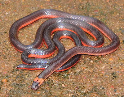
Calliophis castoe, Castoe's Coral Snake, Dichole, Goa. Smith et al. (2012).

Calliophis castoe is a 536-540 mm brownish Snake; the underside is reddish, and a red stripe extends across the back of the head. The snake was found in semi-evergreen or evergreen forests with high annual precipitation at altitudes of up to 715 m. Local people in the areas where the study was carried out informed the researchers that the snakes were extremely common.

Map showing the areas where Calliophis castoe was found. Smith et al. (2012).

 
Forest at Amboli in Maharashtra State, where Calliophis castoe was first discovered. Smith et al. (2012).

See also The Kandyan House Gecko; not extinct after all, Velvet Geckos and Broad-headed Snakes; understanding the population structure of a favoured prey item in order to protect an endangered predator, New species of Girdled Lizard from the Democratic Republic of Congo, New species of Semiaquatic Spectacled Lizard from southern Peru and Reptiles on Sciency Thoughts YouTube.

Follow Sciency Thoughts on Facebook.
 

Tuesday, 28 August 2012

Large Earthquake off the south coast of El Salvador.

On Sunday 26  August 2012, slightly after 10.35 pm local time (slightly after 4.35 am on Monday 27 August, GMT), an Earthquake occurred roughly 100 km off the south coast of El Salvador, which the United States Geological Survey recorded as measuring 7.3 on the Richter Scale, at a depth of 20.3 km. This is a substantial quake, and quite shallow, so even though it is some way offshore , the USGS estimate that there is a 35% chance of this quake leading to fatalities. The Pacific Tsunami Warning Center issued a warning for this quake, but the wave generated was apparently only 20 cm high when it reached Central America; unlikely to have caused anyone serious problems.
 

Map showing the location of the 26 August quake, and the areas worst hit by shaking. The quake would have been felt by most people inside the outermost circle, and there is a risk of damage to buildings within the next circle, which touches the coast of El Salvador. USGS.
 
 
This quake was followed by a large number of aftershocks, some of which exceeded magnitude 5.0, adding to the hazard caused by this event.
 
Map showing recent seismic activity off the south coast of El Salvador. Each square represents a separate quake, with larger quakes represented by larger squares. The yellow squares occurred earlier in the week, the red square is the most recent event. The red line is the Middle American Trench. USGS.
 
El Salvador, and neighbouring Central American states, lies on the Caribbean Plate. To the south of Central America the Coccos Plate, which underlies an area of the east Pacific, is being subducted beneath the Caribbean Plate along the Middle American Trench. As the Coccos Plate is drawn under Central America is causes friction (Earthquakes), which combined with the heat of the planets interior, slightly melts the plate, producing liquid magma, some of which then rises through the overlying Caribbean Plate, fuelling the volcanoes of Central America.
 
 
Follow Sciency Thoughts on Facebook.


Monday, 27 August 2012

Earthquake off the Dorset Coast.

On Sunday 26 August 2012 slightly after 7.35 pm British Summertime (slightly after 8.35 GMT), the British Geological Survey recorded an Earthquake of the coast of Dorset, on the southern English coast, roughly 13 km south of Weymouth at a depth if about 9 km, and measuring 2.0 on the Richter Scale. An Earthquake this small is highly unlikely to have caused any damage, and may not even have been notticed by anyone; or, if it was felt it may not have been recognised as an Earthquake.

Map showing the location of the August 26 Earthquake. BGS.

The precice cause of Earthquakes in the UK can be hard to deternmine; the country is not near any active plate margins, but it is subject to some extent to stresses caused by the expansion of the Atlantic Ocean, which is pushing Europe to the east, and the impact of Africa into Europe from the south. The British Isles are also affected to some extent by lesser areas of extension beneath the North Sea, the Rhine Valley and the Bay of Biscay. Then there is glacial rebound; the north of Brtiain was covered by ice hundreds of meters thick until about 10 000 years ago. This pushed the rocks of the British lithosphere down into the underlying mantle, rocks that are slowly rebounding now the ice has gone. Finally a quake in this area could have been caused by a submarine landslip, or even an underwater explosion, though the Portland Coastguard have no record of any known explosions in the Channel at this time.

Witness accounts of Earthquakes can help geologists to understand their causes; if you felt this quake you can report it to the BGS here. The BGS would also be interested in hearing from people who were in the area but did not feel the quake, which is also useful information.

See also Monmouth Beach, Lyme, closed due to danger of landslips, Woman killed by rockfall on Dorset beach, Earthquake in the Channel Islands, Earthquake beneath the English Channel and Earthquakes on Sciency Thoughts YouTube.

Follow Sciency Thoughts on Facebook.
 

Earthquake swarm strikes southern California.

On Saturday 25 August 2012, at 8.30 am local time (3.30 pm GMT) southeastern California suffered three magnitude 2.5 Earthquakes within the space of a few minutes, the beginning of a swarm of quakes that would persist for several days, with several quakes exceeding magnitude 5.0 on Sunday 26 August. No casualties have been reported, but considerable damage to homes and businesses has been reported around the town of Brawly, where a hospital was also evacuated after repeated power outages.

Map showing southern California and adjacent states of Mexico and the United States. USGS.

The quakes occurred in an area known as the Brawly Seismic Zone, which lies between the Imperial and San Andreas Faults. The Imperial Fault is an extension of the East Pacific Rise, an area of sea-floor spreading that separates the Pacific from the Cocos and Nazca Plates, which runs under the Gulf of California as far north as Imperial County California. The San Andreas Fault is a transform fault which runs under most of the length of the state of California, separating the northward moving Pacific Plate on the west from the southward moving North American Plate to the east.

The Brawly Fault Zone seems to go through periodic bursts of activity, producing swarms of quakes that go on for a number of days, before settling down again. The most recent episodes were in 2005 and 1981; there were a number of episodes in the 1960s and 1970s. The nature of the swarms is not well understood, but it is thought that the Zone is beginning to undergo a process of extension.

Map showing the plate margins underlying the east Pacific and southern North America. Bangor University.

See also Los Angeles Shaken by Earthquake, Earthquake in the Gulf of California, Oaxaca region of Mexico struck by second major Earthquake, Mexico Shaken by major Earthquake and Earthquakes on Sciency Thoughts YouTube.

Follow Sciency Thoughts on Facebook.
 

The Christmas Island Blue Crab recognized as a distinct species.

Christmas Island in the eastern Indian Ocean is noted for its distinctive Crab fauna, most notably the abundant Red Land Crab, Gecarcoidea natalis. Another distinctive form on the island is the Blue Crab, which has generally been regarded as a colour variation on the widespread Discoplax hirtipes, which is found from the Andaman and Nicobar Islands in the west to Hawaii in the east. This lives in burrows beside freshwater pools and streams. 

In a paper published in The Raffles Bulletin of Zoology on 29 February 2012, Peter Ng of the Tropical Marine Science Institute and Raffles Museum of Biodiversity Research at the Department of Biological Sciences at the National University of Singapore, and Peter Davie of the Queensland Museum, formally describe the Christmas Island Blue Crab as a separate species, as a result of a genetic study of the Crabs. 

The Christmas Island Land Crab. Ng & Davie (2012).

The new species is named as Discoplax celeste, celeste implying sky, or heavens, in reference to the sky-blue colour of the Crabs. It is essentially similar to Discoplax hirtipes in form and behavior, and develops its distinctive colouration only as an adult.

Colouration during the growth of Discoplax celeste. (A) juvenile (7.9 × 7.1 mm); (B) female (15.9 × 14.1 mm); (C) female (22.3 × 19.0 mm); (D) female (27.5 × 23.5 mm); (E) female (39.0 × 34.0 mm); (F) male (44.4 × 38.7 mm); (G) female (42.4 × 35.8 mm); (H) female (47.1 × 39.2 mm). Ng & Davie (2012).

Individuals with the purplish-brown with orange claws colouration of Discoplax hirtipes from Sumatra and the Nicobar Islands are also found on Christmas Island. Genetic sampling of these individuals suggested that they were closely related to the Crabs of Sumatra, not greatly surprising as Sumatra is the closest landmass to Christmas Island. Ng & Davie refer to these Crabs as Discoplax aff. hirtipes, on the basis that they suspect that these are likely to be a separate species from the Pacific Crabs.

Discoplax celeste (top) and Discoplax aff. hirtipes (bottom) from Waterfall Bay on Christmas Island. Both about 80 mm in diameter. Ng & Davie (2012).

The recognition of the Blue Crabs as a separate species is important, as these Crabs are increasingly at risk on Christmas Island, due to habitat destruction and invasive species. Recent fieldwork on the island has found very few juvenile specimens, which suggests the Crabs could be in serious difficulties. Recognition of the Blue Crabs as a separate species should (hopefully) ensure better protection for them.


Follow Sciency Thoughts on Facebook.

Sunday, 26 August 2012

Seismic activity beneath Mount Sotará, Columbia.

The Observatorio Vulcanológico and Sismológico de Popayán reported a sharp rise in seismic activity under Mount Sotará in southeast Columbia this month, with 110 Earth tremors of magnitudes between 0.2 and 1.6 at depths of 2-6 km, within 5 km of the summit between the 8th and 14th of August 2012. Such quakes can be the result of magma moving into chambers beneath a volcano, which in turn may be a prelude to an eruption. 

Areal photograph of Mount Sotará taken in December 2007. The 'smoke' around the crater is probably just low cloud. Observatorio Vulcanológico and Sismológico de Popayán.

Mount Sotará is a stratovolcano (cone-shaped volcano made up of layers of ash and lava) slightly over 4400 m high. It has not erupted in recorded history, although it has produced fumaroles (gas emissions), and a complex of hot springs to the southeast is thought to be associated with the volcano.

Like other volcanoes along the west coast of South America, Mount Sotará is fueled by the subduction of the Nazca Plate (which underlies the southeastern Pacific Ocean) beneath the South American Plate. As the Nazca Plate passes under South America it is partially melted by the friction and the heat of the planet's interior. Some of this melted material then rises through the South American Plate, feeding the volcanoes of the Andes.


Follow Sciency Thoughts on Facebook.

Ants in the diet of a Cambodian Pitcher Plant.

Pitcher Plants, or Monkey-cups, are carnivorous plants that trap Insects inside a deep, fluid-filled trap, where their bodies are then digested, providing valuable nutrients for the plants, which are thereby able to survive on very nutrient-poor soils. They are not a true taxonomic group, with different groups of Pitcher Plants apparently having evolved separately from Flypaper Trap Plants, which trap and digest Insects using sticky secretions from their leaves (Flypaper Trap Plants are also polyphyletic; they have evolved separately a number of times).

Pitcher Plants of the genus Nepenthes are found across southern Asia, Indonesia, New Caledonia and Australia, as well as in the Seychelles and Madagascar. They are not thought to be closely related to any other group of Pitcher Plants. 

Previous studies of Plants in the genus Nepenthes have found that Ants form a major part of their diet, but have not looked closely into which Ants are being consumed, either because the remains are often two badly digested for taxonomic identification, or because the scientists involved lacked sufficient expertise in Ant taxonomy. 

In a paper published in the July 2012 edition of the Cambodian Journal of Natural History, Shingo Hosoishi and Sang-Hyung Park of the Institute of Tropical Agriculture at Kyushu University, Seike Yamane of the Department of Earth & Environmental Sciences at the Faculty of Science at Kagoshima University, and Kazuo Ogata, also of the Institute of Tropical Agriculture at Kyushu University present the results of a survey of Ants in the diet of Nepenthes bokorensis, a Pitcher Plant found only on Mount Bokor in southern Cambodia, living on sandy soils at altitudes of between 800 and 1080 m.

A specimen of Nepenthes bokorensis growing in the Phnom Bokor National Park. Don Pirot/Rutgers University.

Hosoishi et al. split a section of forest margin in the Phom Bokor National Park, at an altitude of 900 m,  into 3 transects, 0-5 m, 5-10m and 10-15 m from a forest edge. Each transect contained 10 Pitcher Plants, for a total of 30 individuals. Ants were collected from the traps of these pitcher plants in December 2012.

Ten species of Ant were collected, belonging to nine genera; eight from the transect nearest to the forest edge, ten from the middle transect and six from the outer transect. Species diversity did not significantly vary between the transects.

The most abundant species of Ant, making up 40% of the individuals collected was identified as Polyrhachis (Myrma) sp. These are large Ants, and may contribute significantly to the nutritional requirements of the Pitcher Plants.

Polyrhachis (Myrma) sp. The scale bar is 0.5 mm. Hosoishi et al. (2012).

The next most abundant species was Dolichoderus thoracicus, a widespread southeast Asian species often used as a biological pest-control agent (i.e. often introduced to new areas by humans), due its ability to keep down the numbers of some Insects considered agricultural pests. Dolichoderus thoracicus is highly adaptable, and can nest both on the ground and in the branches of trees.

Dolichoderus thoracicus. The scale bar is 0.5 mm. Hosoishi et al. (2012).

The third most abundant species was identified as Camponotus (Tanaemyrmex) sp., another large species, likely to make a significant contribution to the Pitcher Plant's diet.

Camponotus (Tanaemyrmex) sp., minor worker (there are larger castes of this Ant). The scale bar is 0.5 mm. Hosoishi et al. (2012).

Significant numbers of Ants belonging to the Cardiocondyla wroughtonii complex (complex implies scientists are uncertain of these Ants are all the same species, though they are clearly closely related). These are invasive introduced Ants from tropical Africa, and while they are not as harmful as some introduced Ant species, do appear to be spreading rapidly in southeast Asia. Hosoishi et al. suggest that if this Ant is equally vulnerable to other species of Pitcher Plant, then sampling these plants could be a good way to monitor their spread.

An Ant from the Cardiocondyla wroughtonii complex. The scale bar is 0.5 mm. Hosoishi et al. (2012).

See also New species of Ghost Ant named after Edward O. Wilson, and Evidence of fungal parasites modifying the behavior of ants from the Eocene Messel Shale.

Follow Sciency Thoughts on Facebook.

Saturday, 25 August 2012

A new species of Green Lacewing discovered on Flikr®.

Green Lacewings (Chrysopidae) are a globally distributed group of carnivorous flying Insects, ranging from 6 to 65 mm in length (though the larger forms are exclusively tropical). The main prey of many temperate species is Aphids, making them a popular form of biological control. Green Lacewings were formerly grouped with Brown Lacewings (Hemerobiidae) as 'Lacewings', but these groups are now thought not to be very closely related, with Green Lacewings most closely related to Osmylid Flies (Netwings), while the Brown Lacewings are more closely related to Dustywings (Coniopterygidae), Spongeflies (Sisyridae) and Mantisflies.

In May 2011 amateur naturalist and photographer Hock Ping Guek spotted an unfamiliar Green Lacewing close to the entrance of the Selangor State Park in Peninsular Malaysia, which he photographed. He then placed the images of on the photo-sharing website Flikr®, in the hope that somebody would be able to identify the Insect. The pictures were seen by Shaun Winterton of the California State Collection of Arthropods at the California Department of Food & Agriculture, who realized that this was a species new to science, and contacted Guek to see if he was able to obtain another specimen of the insect, which he was (this is pretty amazing, many tropical insects are known only from single specimens).

Hock Ping Guek's original photograph of the new Green Lacewing. Winterton et al. (2012).

In a paper published in the journal ZooKeys on 7 August 2012, Winterton, Guek and Stephen Brooks of the Department of Entomology at The Natural History Museum in London, formally describe the new Lacewing as Semachrysa jade, Jade's Green Lacewing, in honour of Winterton's daughter, based upon the new specimen obtained by Guek, and another specimen found in the Entomology Collection of The Natural History Museum in London, which was collected in Sabah State, Malaysian Borneo in 1981 (finding new species in museum collections is not unusual, many specimens are collected incidentally, by scientists studying other organisms).

The second specimen, from which the species Semachrysa jade was described. Winterton et al. (2012).

Semachrysa jade is a 15 mm Green Lacewing with a distinctive black marking on both wings. It was found in dense forrest 0.8 km south southwest of entrance of Selangor State Park in Peninsula Malaysia; the terrain where the Sabah specimen was collected is not recorded.

Map showing the location of the site where Guek collected his specimen. Google Maps.

The location of the site where Guek collected his specimen. Winterton et al. (2012).

Line drawing showing the distinctive markings on the wings of Semachrysa jadeAbbreviations: dcc, distal cubital cell; ig, inner gradate series; psc, pseudocubital vein; psm, pseudomedial vein; og; outer gradate series. Scale line: 1.0 mm. Winterton et al. (2012).

See also A new species of Antlion from ChinaSnakeflies in amber from the Early Cretaceous of northern Spain and New species of Owlfly from Morocco.

Follow Sciency Thoughts on Facebook.

Friday, 24 August 2012

Eruption on Ivan Grozny.

On 16 August 2012 the Itar-Tass news agency reported an eruption on the Ivan Grozny (Ivan the Terrible) volcano on Iturup Island in the Kuril Archipelago to the northeast of Hokkaido, producing ash-falls up to 25 km from the caldera. Ivan Grozny forms a caldera 3 × 3.5 km, open to the south. Their are several Holocene (less than 10 000 year old) lava domes to the northeast of this caldera, and a single large dome to the south, which is called the Grozny Dome (Terrible Dome). To the east lies a second volcano, Tebenkov, and south of this the Machekh Crater, which frequently produces fumaroles (gas emissions).

The location of Ivan Grozny. Google Maps.

The first recorded eruption on Ivan Grozny occurred in February 1968, when a small explosive eruption occurred. Similar events happened in 1970, January 1973 and May 1973. In 1989 a series of small eruptions lasted from May to August, triggering several lahars (mud flows), since when the volcano has been quiet.

The Kuril Archipelago runs from the northwestern tip of Hokkaido to the southern tip of the Kamtchatka Peninsula. It marks the southern margin of the Okhotsk Plate, which underlies the Sea of Okhotsk, the Kamchatka Peninsula, Sakhalin Island and Tōhoku and Hokkaidō in Japan. Along this southern margin the Pacific Plate is being subducted beneath the Okhotsk Plate in the Kuril Trench. As the Pacific Plate sinks under the Okhotsk Plate it is partial melted by the resultant friction and the heat of the Earth's interior. Some of the melted material then rises up through the overlying Okhotsk Plate as magma, fueling the volcanoes of the Kuril Archipelago.

Simple diagram showing the subduction of the Pacific Plate beneath the Okhotsk Plate along the Kuril Trench. Auburn University.


Follow Sciency Thoughts on Facebook.

Thursday, 23 August 2012

A new species of Toothcarp from Iran.

The Toothcarps of the genus Aphanius are the only Eurasian members of the Family Cyprinodontidae; all other members of the family are restricted to the Americas, where they are variously known as Pupfish, Flagfish and Killifish (the term Killifish is also used to describe a number of Fish in other families; some members of the genus Aphanius are also called Killifish). Toothcarp are small carnivorous fish found in rivers and ponds across southern Europe, North Africa and southwest Asia; they are not closely related to true Carp.

In a paper published in the journal ZooKeys on 17 August 2012, a team of scientists led by Azad Teimori of the Department of Earth and Environmental Sciences at Ludwig-Maximilians-University, and the Department of Biology at the Faculty of Sciences at Shahid-Bahonar University of Kerman, describe a new species of Toothcarp from Namak Lake basin in Markazi Province in north-central Iran.

The new species of Toothcarp was discovered during fieldwork in 2007 in a shallow pond in the Namak Lake basin, 5 km south east of the city of Arak. The pond was roughly  4 × 6 m, and fed by drainage from a natural spring. The water was warm (23℃), and semi-stagnant. The pool had a muddy bottom with some gravel and lacked vegetation; the surrounding area was dominated by Rushes and Bulrushes. The new Fish was the only species present, it was also found in a number of nearby springs.

The pool in which the new species of Toothcarp was discovered. Teimori et al. (2012).

The new species is named Aphanius arakensis, the Arak Toothcarp, it is a 22.5-38.5 mm fish that was identified as a probable new species on the basis of the distinctive male colouration (dark grey with blue bars, the females are grayish), and this was later confirmed on the basis of otolith (ear-bone) morphology and gene sequencing.

Aphanius arakensis. (Top) male. (Bottom) female. Teimori et al. (2012).

The number of species of Aphanius in Iran has increased rapidly in recent years, since it has been discovered that differences in male colouration usually reflect different species, suggesting that sexual selection is the major driver of speciation in the group here (and probably elsewhere). It is highly probable that more species will be described in the group in the near future.

Map showing the distribution of endemic Aphanius species in Iran. Teimori et al. (2012).


Follow Sciency Thoughts on Facebook.

Wednesday, 22 August 2012

A fossil Insect from the Late Devonian of Belgium.

The Insects are thought to have first emerged in the Silurian Period, over 416 million years ago, though fossil insects are very rare earlier than the Late Carboniferous, becoming more common after 345 million years ago. Whether this means that insects were rare in this interval, or simply were not preserved is unclear. Traditionally interpretation of the palaeontological record has suggested that the Insects underwent a major bout of diversification during the Late Carboniferous, but recent molecular studies have suggested that several groups of Insects might be older than this.

In a paper published in the journal Nature on 2 August 2012, a team of scientists led by Romain Garrouste of Entomologie at the Muséum national d’Histoire naturelle in Paris, describe the discovery of a complete fossil Insect from the Late Famennian (364.7-360.7 million years old, Late Devonian) Bois des Mouches Formation at Strud in Namur Province, Belgium.

Map showing the location where the new fossil was found. Google Maps.

The new fossil is named Strudiella devonica, the Devonian little fossil from Strud. It is an 8 mm long Arthropod with a body divided into head, thorax and abdomen with three pairs of legs on the thorax (the diagnostic features of an Insect). It also has a pair of long antennae, and mandibles (jaws) which suggest an omnivorous diet. Its bodyplan is more suggestive of a winged Insect than a non-winged Insect, however it lacks wings, suggesting that it might be a nymph of an Insect which underwent incomplete metamorphosis (such as a Dragonfly); in such Insects the larval form (nymph) resembles the adult, but lacks wings and is often aquatic.

Strudiella devonica (Top) Photograph. (Bottom) Interpretive drawing. White arrows
indicate legs visible on part. abd, abdomen; ant, antenna; h, head; md, mandible. Scale bar, 1mm. Garrouste et al. (2012).


Follow Sciency Thoughts on Facebook.

Tuesday, 21 August 2012

New species of Ghost Ant named after Edward O. Wilson.

Ghost Ants of the genus Tapinoma are small stingless ants with a worldwide distribution. There are over sixty described species, including the sun-loving European Erratic Ant (Tapinoma erraticum), the widespread pest species Tapinoma melanocephalum, and the North American Odorous House Ant. 

In a paper published in the journal ZooKeys on 30 July 2012, Mostafa Sharaf and Abdulrahman Aldawood of the Plant Protection Department of the College of Food and Agriculture Sciences at King Saud University, and Magdi ElHawagry of the Basic Sciences Department of the Community College at Al-Baha University, describe a new species of Ghost Ant from Dhi Ayn Archaeological Village in the Al Sarawat Mountains of Saudi Arabia.

The Dhi Ayn Archaeological Village in Al Bahah Province, where the new species of Ant was discovered. Brian Fisher in Sharaf et al. (2012).

The new species is named Tapinoma wilsoni, in honour of the celebrated ecologist, ant specialist and popular biology writer Edward O. Wilson of the Harvard University Museum of Comparative Zoology.  The species is described on the basis of 30 worker Ants captured during field-work in 2011. These are 1.56-1.84 mm Ants, yellow or brownish-yellow in colour and covered in fine hairs.

Tapinoma wilsoni in lateral view. Sharaf et al. (2012).

Tapinoma wilsoni in dorsal view. Sharaf et al. (2012).

Frontal view of the head of Tapinoma wilsoniSharaf et al. (2012).


Follow Sciency Thoughts on Facebook.

Water and Hydroxides in the Circumstellar Disk around HD 163296.

HD 163296 is a young Herbig Ae star (a star producing heat by gravitational collapse, which is expected will fuse Hydrogen in the future, but which has not reached this stage yet) slightly under 400 light years from Earth. It is surrounded by a fairly well documented circumstellar disk, which reaches slightly over 900 AU from the star (i.e. over 900 times as far from the star as Earth is from the Sun). Such disks around young stars are thought to provide the reserve of material from which planets form, making understanding the processes that go on within them important for understanding the formation of planets.

Hubble Space Telescope image of the disk around HD 163296. Grady et al. (2000).

In a paper published on the online arXiv database at Cornell University Library on 17 July 2012, and in the journal Astronomy & Astrophysics on 18 July 2012, a team of scientists led by Davide Fedele of the Max Planck Institut für Extraterrestrische Physik describe the discovery of a band of warm, gaseous, Water (H₂O) and Hydroxide (HO) molecules within the HD 163296 Circumstellar Disk, using the Spitzer Space Telescope.

The H₂O producing region was found to be 15-20 AU from the star, and to have a temperature of 200-300 K (-73.15 to 26.85 ℃). This would be to cold for gaseous water on Earth, but in space water sublimates directly from a solid to a gas, so this is less surprising. It is not clear if the molecules were being produced by the disk, or were being ejected from the star, which is known to produce microjets of material from its polar regions.


Follow Sciency Thoughts on Facebook.